mountainous terraces (Abdullah)

Bench terraces covered with small stones (Yémen)

المدرجات المغطاه بالأحجار

Description

Building terraces in steep areas for the purpose of reducing the slope, water harvesting and soil moisture conservation.

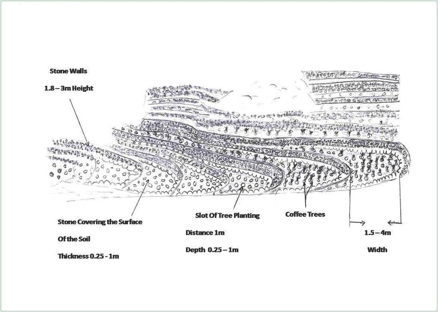
Cutting and collecting stones for the construction of terraces on steep slopes of the mountains, structural measure to reduce the length and angle of the slope and the speed of runoff. This makes it easier to harvest water and reserving deposits. A wall terraces is built of stones where the height of a wall should be increased height of 1.8 - 3 m, a width of 1.5 - 4.3 m and the length from 8 - 14 m to keep the accumulated deposits. The cutting stones are brought from distant places for the purpose of building the walls. These terraces are similar to mountain terraces but the top soil surface can be covered with stones to protect it from heavy rain storms and prevent sheet erosion that results from raindrops hitting the bare top soil surface. The stone layer, also prevents evaporation and maintains soil moisture. The stones are arranged in a layer of about 0.25 – 0.7 m thickness over the entire surface of the soil except where to put the coffee trees with an average diameter of 1 m. It is difficult to use equipment in the process of building the terraces due to severe slopes. Therefore it is a labor intensive process of manually building terraces. Due to the slow process of construction it requires a lot of time. However, building terraces on steep slopes can lead to increased erosion in the absence of well maintaining outlets that allow draining the excess water from one terrace to another, avoiding breaking of terraces' walls. In any case, terraces need regular maintenance to ensure the sustainability of this technology. The landscape of the region is mountainous, bench terraces which are used for crop production exist in slopes exceeding 60%. The texture of the soil is silty loam and the depth of the terraces is moderate to deep. Due to small holdings and steepness of the terraces, the local implements are used for land preparation. The climate in the region is arid to semi-arid and annual precipitation ranges between 200 and 450 mm. The major crop in this area is coffee, which is cultivated because of its high economic value on the market.

Lieu

Lieu: Bani Ismail- Manakha District, Sanaa governorate, Yémen

Nbr de sites de la Technologie analysés:

Géo-référence des sites sélectionnés
  • 43.62591, 15.17941

Diffusion de la Technologie: répartie uniformément sur une zone (approx. 0,1-1 km2)

Dans des zones protégées en permanence ?:

Date de mise en oeuvre: il y a plus de 50 ans (technologie traditionnelle)

Type d'introduction
Coffee plantation in the terraces (Abdullah)
mountain terraces

Classification de la Technologie

Principal objectif
  • améliorer la production
  • réduire, prévenir, restaurer les terres dégradées
  • préserver l'écosystème
  • protéger un bassin versant/ des zones situées en aval - en combinaison avec d'autres technologies
  • conserver/ améliorer la biodiversité
  • réduire les risques de catastrophes
  • s'adapter au changement et aux extrêmes climatiques et à leurs impacts
  • atténuer le changement climatique et ses impacts
  • créer un impact économique positif
  • créer un impact social positif
L'utilisation des terres

  • Terres cultivées
    • Plantations d’arbres ou de buissons: café, cultivé en plein champ
    Nombre de période de croissance par an: : 1
Approvisionnement en eau
  • pluvial
  • mixte: pluvial-irrigué
  • pleine irrigation

But relatif à la dégradation des terres
  • prévenir la dégradation des terres
  • réduire la dégradation des terres
  • restaurer/ réhabiliter des terres sévèrement dégradées
  • s'adapter à la dégradation des terres
  • non applicable
Dégradation des terres traité
  • érosion hydrique des sols - Wg: ravinement/ érosion en ravines
  • dégradation biologique - Bc: réduction de la couverture végétale
  • dégradation hydrique - Ha: aridification
Groupe de GDT
  • mesures en travers de la pente
  • récupération/ collecte de l'eau
  • dérivation et drainage de l'eau
Mesures de GDT
  • structures physiques - S1: Terrasses

Dessin technique

Spécifications techniques
Flat agricultural terraces covered with stones on the soil surface

Location: Bani Ismail. Sana'a governorate - Manakha district

Date: 5/3/2013

Technical knowledge required for field staff / advisors: high (Construction process needs skill and experience)

Technical knowledge required for land users: low (Has experience)

Main technical functions: control of raindrop splash, reduction of slope angle, reduction of slope length, increase / maintain water stored in soil, water harvesting / increase water supply, Reduce speed of runoff

Secondary technical functions: sediment retention / trapping, sediment harvesting

Terrace: bench level
Vertical interval between structures (m): 1.8 -3
Spacing between structures (m): 1.5 – 4.3
Height of bunds/banks/others (m): 1.8 -3
Width of bunds/banks/others (m): 1.5– 4.3
Length of bunds/banks/others (m): 8 - 14

Structural measure: The Coverage with stones
Width of bunds/banks/others (m): 1.5– 4.3
Length of bunds/banks/others (m): 8 - 14

Construction material (earth): Remove residuals of water erosion and refill the soil-eroded with soil

Construction material (stone): Construction of walls from the existing stones in the region

Slope (which determines the spacing indicated above): 66.7%

Lateral gradient along the structure: 0%

For water harvesting: the ratio between the area where the harvested water is applied and the total area from which water is collected is: 1:1
Author: AL Galal

Mise en œuvre et entretien : activités, intrants et coûts

Calcul des intrants et des coûts
  • Les coûts sont calculés :
  • Monnaie utilisée pour le calcul des coûts : dollars américains
  • Taux de change (en dollars américains - USD) : 1 USD = n.d.
  • Coût salarial moyen de la main-d'oeuvre par jour : 6.30
Facteurs les plus importants affectant les coûts
1- Collecting and transporting stones and arable soil manually as a result of the bad road accessibility. 2- Severe steep slopes
Activités de mise en place/ d'établissement
  1. Remove the spate deposits and filing the gullies with soil, then the top soil surface has to be leveled (Calendrier/ fréquence: Before the rain season)
  2. Collecting and transporting stones (Calendrier/ fréquence: Before the rain season)
  3. Building the walls of the terraces (Calendrier/ fréquence: Before the rain season)
  4. Cover the top soil surface of the earth with stones (Calendrier/ fréquence: Before the rain season)
Intrants et coûts de mise en place
Spécifiez les intrants Unité Quantité Coûts par unité (dollars américains) Coût total par intrant (dollars américains) % des coût supporté par les exploitants des terres
Main d'œuvre
Building terraces ha 1,0 42430,0 42430,0 11,0
Equipements
Tools ha 1,0 100,0 100,0 100,0
Coût total de mise en place de la Technologie 42'530.0
Coût total de mise en place de la Technologie en dollars américains (USD) 42'530.0
Activités récurrentes d'entretien
  1. Repair walls that were destroyed (Calendrier/ fréquence: annually after the rain season)
  2. Inverse the soil covered with stones (Calendrier/ fréquence: None)
Intrants et coûts de l'entretien
Spécifiez les intrants Unité Quantité Coûts par unité (dollars américains) Coût total par intrant (dollars américains) % des coût supporté par les exploitants des terres
Main d'œuvre
Repair walls that were destroyed ha 1,0 50,0 50,0 100,0
Inverse the soil covered with stones ha 1,0 186,0 186,0 100,0
Coût total d'entretien de la Technologie 236.0
Coût total d'entretien de la Technologie en dollars américains (USD) 236.0

Environnement naturel

Précipitations annuelles
  • < 250 mm
  • 251-500 mm
  • 501-750 mm
  • 751-1000 mm
  • 1001-1500 mm
  • 1501-2000 mm
  • 2001-3000 mm
  • 3001-4000 mm
  • > 4000 mm
Zones agro-climatiques
  • humide
  • subhumide
  • semi-aride
  • aride
Spécifications sur le climat
Thermal climate class: temperate
Pentes moyennes
  • plat (0-2 %)
  • faible (3-5%)
  • modéré (6-10%)
  • onduleux (11-15%)
  • vallonné (16-30%)
  • raide (31-60%)
  • très raide (>60%)
Reliefs
  • plateaux/ plaines
  • crêtes
  • flancs/ pentes de montagne
  • flancs/ pentes de colline
  • piémonts/ glacis (bas de pente)
  • fonds de vallée/bas-fonds
Zones altitudinales
  • 0-100 m
  • 101-500 m
  • 501-1000 m
  • 1001-1500 m
  • 1501-2000 m
  • 2001-2500 m
  • 2501-3000 m
  • 3001-4000 m
  • > 4000 m
La Technologie est appliquée dans
  • situations convexes
  • situations concaves
  • non pertinent
Profondeurs moyennes du sol
  • très superficiel (0-20 cm)
  • superficiel (21-50 cm)
  • modérément profond (51-80 cm)
  • profond (81-120 cm)
  • très profond (>120 cm)
Textures du sol (de la couche arable)
  • grossier/ léger (sablonneux)
  • moyen (limoneux)
  • fin/ lourd (argile)
Textures du sol (> 20 cm sous la surface)
  • grossier/ léger (sablonneux)
  • moyen (limoneux)
  • fin/ lourd (argile)
Matière organique de la couche arable
  • abondant (>3%)
  • moyen (1-3%)
  • faible (<1%)
Profondeur estimée de l’eau dans le sol
  • en surface
  • < 5 m
  • 5-50 m
  • > 50 m
Disponibilité de l’eau de surface
  • excès
  • bonne
  • moyenne
  • faible/ absente
Qualité de l’eau (non traitée)
  • eau potable
  • faiblement potable (traitement nécessaire)
  • uniquement pour usage agricole (irrigation)
  • eau inutilisable
La qualité de l'eau fait référence à:
La salinité de l'eau est-elle un problème ?
  • Oui
  • Non

Présence d'inondations
  • Oui
  • Non
Diversité des espèces
  • élevé
  • moyenne
  • faible
Diversité des habitats
  • élevé
  • moyenne
  • faible

Caractéristiques des exploitants des terres appliquant la Technologie

Orientation du système de production
  • subsistance (auto-approvisionnement)
  • exploitation mixte (de subsistance/ commerciale)
  • commercial/ de marché
Revenus hors exploitation
  • moins de 10% de tous les revenus
  • 10-50% de tous les revenus
  • > 50% de tous les revenus
Niveau relatif de richesse
  • très pauvre
  • pauvre
  • moyen
  • riche
  • très riche
Niveau de mécanisation
  • travail manuel
  • traction animale
  • mécanisé/ motorisé
Sédentaire ou nomade
  • Sédentaire
  • Semi-nomade
  • Nomade
Individus ou groupes
  • individu/ ménage
  • groupe/ communauté
  • coopérative
  • employé (entreprise, gouvernement)
Genre
  • femmes
  • hommes
Âge
  • enfants
  • jeunes
  • personnes d'âge moyen
  • personnes âgées
Superficie utilisée par ménage
  • < 0,5 ha
  • 0,5-1 ha
  • 1-2 ha
  • 2-5 ha
  • 5-15 ha
  • 15-50 ha
  • 50-100 ha
  • 100-500 ha
  • 500-1 000 ha
  • 1 000-10 000 ha
  • > 10 000 ha
Échelle
  • petite dimension
  • moyenne dimension
  • grande dimension
Propriété foncière
  • état
  • entreprise
  • communauté/ village
  • groupe
  • individu, sans titre de propriété
  • individu, avec titre de propriété
Droits d’utilisation des terres
  • accès libre (non organisé)
  • communautaire (organisé)
  • loué
  • individuel
Droits d’utilisation de l’eau
  • accès libre (non organisé)
  • communautaire (organisé)
  • loué
  • individuel
Accès aux services et aux infrastructures
santé

pauvre
x
bonne
éducation

pauvre
x
bonne
assistance technique

pauvre
x
bonne
emploi (par ex. hors exploitation)

pauvre
x
bonne
marchés

pauvre
x
bonne
énergie

pauvre
x
bonne
routes et transports

pauvre
x
bonne
eau potable et assainissement

pauvre
x
bonne
services financiers

pauvre
x
bonne

Impact

Impacts socio-économiques
Production agricole
en baisse
x
en augmentation

risque d'échec de la production
en augmentation
x
en baisse

surface de production (nouvelles terres cultivées/ utilisées)
en baisse
x
en augmentation

gestion des terres
entravé
x
simplifié

revenus agricoles
en baisse
x
en augmentation

charge de travail
en augmentation
x
en baisse

Growth of weeds competing for water
enabling
x
prvention


Due to coverage of the top surface of soil with stones

Impacts socioculturels
sécurité alimentaire/ autosuffisance
réduit
x
amélioré

connaissances sur la GDT/ dégradation des terres
réduit
x
amélioré

apaisement des conflits
détérioré
x
amélioré


As a result of not repair the damage occurring in some of the terraces and that lead to the damage of other terraces.

Impacts écologiques
récolte/ collecte de l'eau (ruissellement, rosée, neige, etc.)
réduit
x
amélioré

ruissellement de surface
en augmentation
x
en baisse

drainage de l'excès d'eau
réduit
x
amélioré

évaporation
en augmentation
x
en baisse

humidité du sol
en baisse
x
en augmentation

couverture du sol
réduit
x
amélioré

perte en sol
en augmentation
x
en baisse

encroûtement/ battance du sol
en augmentation
x
réduit

compaction du sol
en augmentation
x
réduit

soil fertility
decreased
x
increased

Impacts hors site
inondations en aval (indésirables)
en augmentation
x
réduit

envasement en aval
en augmentation
x
en baisse

Analyse coûts-bénéfices

Bénéfices par rapport aux coûts de mise en place
Rentabilité à court terme
très négative
x
très positive

Rentabilité à long terme
très négative
x
très positive

Bénéfices par rapport aux coûts d'entretien
Rentabilité à court terme
très négative
x
très positive

Rentabilité à long terme
très négative
x
très positive

Changement climatique

Changements climatiques progressifs
températures annuelles augmente

pas bien du tout
x
très bien
Extrêmes climatiques (catastrophes)
pluie torrentielle locale

pas bien du tout
x
très bien
sécheresse

pas bien du tout
x
très bien

Adoption et adaptation de la Technologie

Pourcentage d'exploitants des terres ayant adopté la Technologie dans la région
  • cas isolés/ expérimentaux
  • 1-10%
  • 11-50%
  • > 50%
Parmi tous ceux qui ont adopté la Technologie, combien d'entre eux l'ont fait spontanément, à savoir sans recevoir aucune incitation matérielle ou aucun paiement ?
  • 0-10%
  • 11-50%
  • 51-90%
  • 91-100%
Nombre de ménages et/ou superficie couverte
120 households covering 100 percent of the stated area
La Technologie a-t-elle été récemment modifiée pour s'adapter à l'évolution des conditions ?
  • Oui
  • Non
A quel changement ?
  • changements/ extrêmes climatiques
  • évolution des marchés
  • la disponibilité de la main-d'œuvre (par ex., en raison de migrations)

Conclusions et enseignements tirés

Points forts: point de vue de l'exploitant des terres
Points forts: point de vue du compilateur ou d'une autre personne-ressource clé
  • This ancient technology is original and appropriate to the local situation

    How can they be sustained / enhanced? Raise awareness among land users of the importance of maintaining the technology.
  • The sustainable cropping of the soil terraces on steep slopes prevent soil loss and degradation

    How can they be sustained / enhanced? Continue maintenance and appropriate land management
  • Increase soil moisture

    How can they be sustained / enhanced? Periodic maintenance
  • Reducing runoff and increasing water harvesting

    How can they be sustained / enhanced? Periodic maintenance
  • Improve soil fertility

    How can they be sustained / enhanced? Continue to add organic matter to increase soil fertility and conservation
Faiblesses/ inconvénients/ risques: point de vue de l'exploitant des terrescomment surmonter
Faiblesses/ inconvénients/ risques: point de vue du compilateur ou d'une autre personne-ressource clécomment surmonter
  • The high cost of rehabilitation and maintenance of the terraces by an individual user Strengthening cooperation and assistance in the rehabilitation and maintenance collectively by land users
  • High runoff may lead to the erosion of terraces Planting the upper part of higher slopes with trees or water breakers (controls) for water runoff to reduce the flow velocity, as well as periodic maintenance of watercourses and water outlets in the terraces
  • Cover the surface of the soil with stones may lead to soil compaction To avoid compaction due to covering soil with stones reduce the thickness of this layer

Références

Compilateur
  • ahmed algalal
Editors
Examinateur
  • David Streiff
  • Alexandra Gavilano
Date de mise en oeuvre: 30 avril 2013
Dernière mise à jour: 13 août 2019
Personnes-ressources
Description complète dans la base de données WOCAT
Données de GDT correspondantes
La documentation a été facilitée par
Institution Projet
Références clés
  • Technical study for construction and reclamation for terraces in some villages, Bani Ismail's uzlah, Manakhah district.2- Mid-monthly reports for implanting terraces construction in Bani Ismail's uzlah, Manakhah district.3- General Census of Population, Housing and Establishment (Census, 2004).4- Guide of agricultural climate in Yemen (Al Khorasani, 2005).: Social Fund for Development, Sana'a 976714496722- Social Fund for Development, Sana'a 97671449672 3-Central Bureau of Statistics4-Agricultural Research and Extension Authority, AREA
This work is licensed under Creative Commons Attribution-NonCommercial-ShareaAlike 4.0 International