Silt fences to trap sediment in areas affected by gully erosion
(Afrique du Sud)
Silt fences
Description
Silt fences together with brush packing were introduced to reduce sediment transport and restoration of gully erosion in the Potlake nature reserve, Limpopo Province, South Africa.
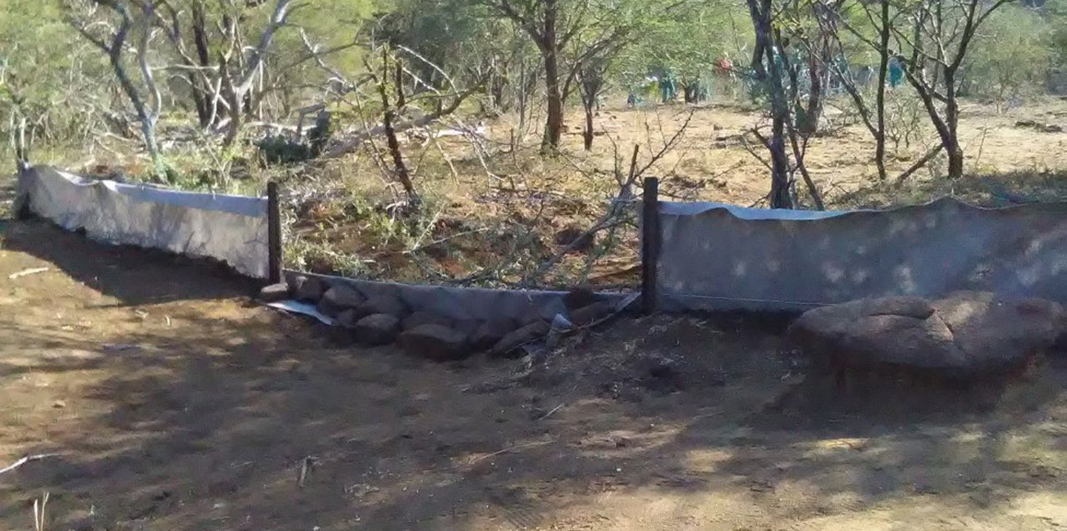
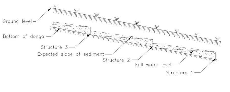
Silt fences, together with brush packing were introduced in the Potlake Game Reserve (2817 ha) in the Limpopo Province of South Africa to rehabilitate areas affected by serious rill and gully erosion. Due to overgrazing on highly erodible soils, gully headcuts are actively migrating upstream. Implementation of the technology leads to enhanced vegetation cover and reduced sediment transport in the gullies. Silt fences are temporary structures and are therefore placed closer together than permanent structures. The placing is such that the silt from the downstream structure builds up against the upstream structure to delay the perishing of the restoration materials. Vegetation must be established in the gully (donga) as soon as possible so that, when the materials decay after about ten years, the area will be restored. Altitudes vary from 1 174 m to 780 m above sea level. The reserve is located in a summer rainfall region and receives an average annual rainfall of 438 mm per year. Clayey duplex soils are prone to both natural and man-induced erosion. The vegetation comprises Central Bushveld vegetation units of the Savanna Biome. Savanna is characterized by a herbaceous layer (usually dominated by grasses) with a woody component. In Southern Africa, Bushveld is an apt description of the vegetation structure, as the vegetation most often does not comprise distinct shrub and tree layers. Instead, the shrubs and trees occur in a matrix with a grass-dominated herb layer. A number of large gullies exist along drainage lines on highly erodible soils. Some of the gullies are up to 1.5 m deep and 5 m wide. A total of around 200 m of silt fences were erected at selected sites in the reserve to retain sediment and to establish vegetation. The following steps were followed in the establishment of the silt fences:
1. Identification of priority sites to erect the silt fences - using Google Earth imagery and field surveys.
2. Acquisition of restoration material and training of local community members on the implementation of the technology (training by Mr. Buckle at that stage from the Department).
3. Levelling of the area where fences would be erected.
4. Construction of fences.
5. Brush packing (upstream of fence) stone packing (downstream in the gully).
Lieu
Lieu: Potlake nature reserve, Limpopo Province, Afrique du Sud
Nbr de sites de la Technologie analysés: 100-1000 sites
Géo-référence des sites sélectionnés
Diffusion de la Technologie: répartie uniformément sur une zone (approx. 1-10 km2)
Dans des zones protégées en permanence ?: Oui
Date de mise en oeuvre: il y a moins de 10 ans (récemment)
Type d'introduction
-
grâce à l'innovation d'exploitants des terres
-
dans le cadre d'un système traditionnel (> 50 ans)
-
au cours d'expérimentations / de recherches
-
par le biais de projets/ d'interventions extérieures
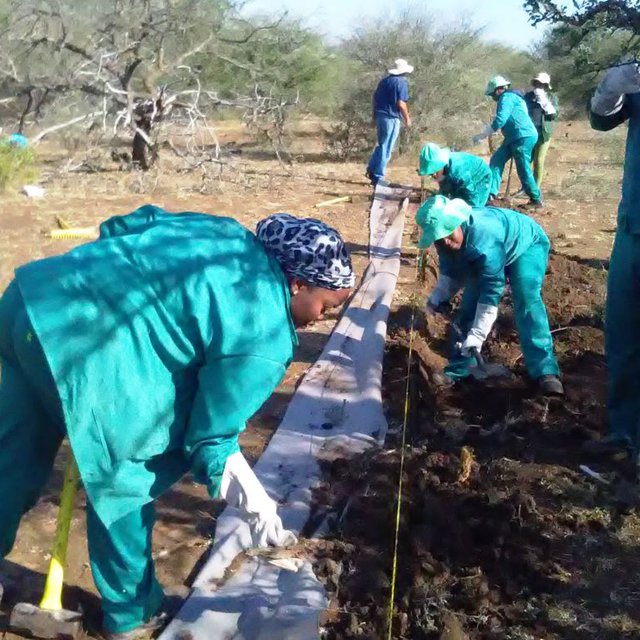
Workers busy erecting silt fences (Heinrich van Heerden)
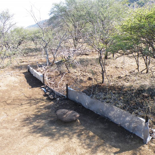
Completed silt fence (Heinrich van Heerden)
Classification de la Technologie
Principal objectif
-
améliorer la production
-
réduire, prévenir, restaurer les terres dégradées
-
préserver l'écosystème
-
protéger un bassin versant/ des zones situées en aval - en combinaison avec d'autres technologies
-
conserver/ améliorer la biodiversité
-
réduire les risques de catastrophes
-
s'adapter au changement et aux extrêmes climatiques et à leurs impacts
-
atténuer le changement climatique et ses impacts
-
créer un impact économique positif
-
créer un impact social positif
L'utilisation des terres
Les divers types d'utilisation des terres au sein du même unité de terrain: Non
-
Autre - Précisez: Protected area
Remarques: Potlake nature reserve
Approvisionnement en eau
-
pluvial
-
mixte: pluvial-irrigué
-
pleine irrigation
But relatif à la dégradation des terres
-
prévenir la dégradation des terres
-
réduire la dégradation des terres
-
restaurer/ réhabiliter des terres sévèrement dégradées
-
s'adapter à la dégradation des terres
-
non applicable
Dégradation des terres traité
-
érosion hydrique des sols - Wt: perte de la couche superficielle des sols (couche arable)/ érosion de surface, Wg: ravinement/ érosion en ravines
Groupe de GDT
-
Amélioration de la couverture végétale/ du sol
-
mesures en travers de la pente
Mesures de GDT
-
structures physiques - S6: Murs, barrières, palissades, clôtures
Dessin technique
Spécifications techniques
Silt fences are temporary structures and are therefore placed closer together than permanent structures. The placing is such that the silt from the downstream structure builds up against the upstream structure to delay the perishing of the restoration materials. Vegetation must be established in the gully (donga) as soon as possible so that, when the materials decay after about ten years, the area will be restored.
Author: Jan van Heerden
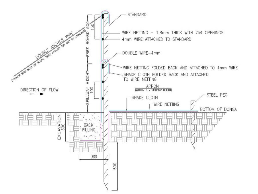
1. Dig a pit trench 300 mm × 300 mm from peg to peg over the entire width of the gully.
2. Drive iron standards (iron pole) in on the sides of the spillway length followed by more standards around 1.5 meters apart - ensure equal spacing between standards (standards must be driven in at least 500 mm deep - ensure that eyes (holes in standards) point upstream and that poles are in line with the others. Place apron on the ground from the excavation downstream. The width of the material must be three times the height of the overflow height and it must be at least 500 mm longer on both sides than the spillway length.
3. Span a 4 mm wire between the spillway poles on the total height of the structure. Tighten only manually and fasten on both sides of the two standards.
4. Drive in two anchor poles in line with the structure on both sides of the donga wall.
5. Saw off or cut heads of standards on the height of the structure’s height. Place anchor wires between two outer poles and anchor poles and tighten.
6. Thread 4 mm wire through on spillway height from side to side and bind to the two poles anchored to the anchor poles.
7. Also place wire between the spillway width poles and the end pole on the structure height and tighten.
8. Span wires from the spillway height wire on 100 mm to 150 mm distances apart, downwards until the last wire is at least 100 mm below the surface.
9. Place netting material (course plastic grid placed behind the filter material) on upstream side of the poles into the excavated pit trench and cut according to shape of the structure.
10. Place filter material flat in the pit trench and in front of the netting material on the upstream side of the poles and cut according to the shape of the structure. Tie the material to the structure with binding wire and fill the pit trench with soil.
11. Place netting material on the apron and tie it to the structure with binding wire and drive in T pegs at strategic places on downstream side.
12. The construction of the drop inlet is built in the same way as a weir structure as close as possible to the head of the donga. The gap between the structure and the donga head is filled with soil and must be filled again after the first rains. The spillway is made ±100 mm higher than the normal ground surface. The structure can be built to a maximum of 1 000 mm from the gully floor to the ground level.
13. Brush packing in front of the silt fence and stone packing downstream of the apron in the gully.
14. In order for silt fences to function more efficiently, it is recommended that that portion of the veld is fenced and withdrawn from grazing. Sowing of grasses or planting of common reed or vetiver grass can speed up the repair process considerably.
Author: Jan van Heerden
Mise en œuvre et entretien : activités, intrants et coûts
Calcul des intrants et des coûts
- Les coûts sont calculés : par entité de la Technologie (unité : silt fence volume, length: 6 to 8 meters)
- Monnaie utilisée pour le calcul des coûts : Rand
- Taux de change (en dollars américains - USD) : 1 USD = 16.0 Rand
- Coût salarial moyen de la main-d'oeuvre par jour : R200
Facteurs les plus importants affectant les coûts
1. Timing - during the raining season these areas could be inaccessible due to clayey soils and water in gullies.
2, Availability of labour.
Activités de mise en place/ d'établissement
-
Preparation of the site to be restored (Calendrier/ fréquence: Winter (outside raining season))
-
Installation of silt fences followed by brush and stone packing (Calendrier/ fréquence: Winter)
Intrants et coûts de mise en place (per silt fence)
| Spécifiez les intrants |
Unité |
Quantité |
Coûts par unité (Rand) |
Coût total par intrant (Rand) |
% des coût supporté par les exploitants des terres |
|
Main d'œuvre
|
| Unskilled labour (including transport) |
Per day |
6,0 |
280,0 |
1680,0 |
|
|
Equipements
|
| Power tools - electric power generator, angle grinder, hammer drill, |
Per day |
3,0 |
500,0 |
1500,0 |
|
| Measuring tape, wire tensioning tool, pole driver, heavy and light hammers, pick, spade, pliers and scissors |
Per day |
10,0 |
20,0 |
200,0 |
|
|
Matériaux de construction
|
| 4mm wire |
Per meter |
100,0 |
15,0 |
1500,0 |
|
| Standards |
Per piece |
6,0 |
90,0 |
540,0 |
|
| Netting |
Per meter |
15,0 |
90,0 |
1350,0 |
|
| Anchor poles |
Per piece |
6,0 |
10,0 |
60,0 |
|
| T pegs |
Per piece |
20,0 |
20,0 |
400,0 |
|
| Binding wire |
Per kg |
5,0 |
40,0 |
200,0 |
|
| Filter material (UV treated shade cloth - 80%) |
Per meter |
86,0 |
20,0 |
1720,0 |
|
| Coût total de mise en place de la Technologie |
9'150.0 |
|
| Coût total de mise en place de la Technologie en dollars américains (USD) |
571.88 |
|
Activités récurrentes d'entretien
-
Repair of fences after floods (Calendrier/ fréquence: After flooding event)
Intrants et coûts de l'entretien (per silt fence)
| Spécifiez les intrants |
Unité |
Quantité |
Coûts par unité (Rand) |
Coût total par intrant (Rand) |
% des coût supporté par les exploitants des terres |
|
Main d'œuvre
|
| Repair of fences |
Per day |
2,0 |
280,0 |
560,0 |
|
|
Equipements
|
| Pliers, hammers, wire tensioning tool, pick, spade, pliers and scissors |
Per day |
5,0 |
20,0 |
100,0 |
|
|
Matériaux de construction
|
| Binding wire and filter material |
Per meter |
4,0 |
150,0 |
600,0 |
|
| Coût total d'entretien de la Technologie |
1'260.0 |
|
| Coût total d'entretien de la Technologie en dollars américains (USD) |
78.75 |
|
Environnement naturel
Précipitations annuelles
-
< 250 mm
-
251-500 mm
-
501-750 mm
-
751-1000 mm
-
1001-1500 mm
-
1501-2000 mm
-
2001-3000 mm
-
3001-4000 mm
-
> 4000 mm
Zones agro-climatiques
-
humide
-
subhumide
-
semi-aride
-
aride
Spécifications sur le climat
Précipitations moyennes annuelles en mm : 438.0
Pentes moyennes
-
plat (0-2 %)
-
faible (3-5%)
-
modéré (6-10%)
-
onduleux (11-15%)
-
vallonné (16-30%)
-
raide (31-60%)
-
très raide (>60%)
Reliefs
-
plateaux/ plaines
-
crêtes
-
flancs/ pentes de montagne
-
flancs/ pentes de colline
-
piémonts/ glacis (bas de pente)
-
fonds de vallée/bas-fonds
Zones altitudinales
-
0-100 m
-
101-500 m
-
501-1000 m
-
1001-1500 m
-
1501-2000 m
-
2001-2500 m
-
2501-3000 m
-
3001-4000 m
-
> 4000 m
La Technologie est appliquée dans
-
situations convexes
-
situations concaves
-
non pertinent
Profondeurs moyennes du sol
-
très superficiel (0-20 cm)
-
superficiel (21-50 cm)
-
modérément profond (51-80 cm)
-
profond (81-120 cm)
-
très profond (>120 cm)
Textures du sol (de la couche arable)
-
grossier/ léger (sablonneux)
-
moyen (limoneux)
-
fin/ lourd (argile)
Textures du sol (> 20 cm sous la surface)
-
grossier/ léger (sablonneux)
-
moyen (limoneux)
-
fin/ lourd (argile)
Matière organique de la couche arable
-
abondant (>3%)
-
moyen (1-3%)
-
faible (<1%)
Profondeur estimée de l’eau dans le sol
-
en surface
-
< 5 m
-
5-50 m
-
> 50 m
Disponibilité de l’eau de surface
-
excès
-
bonne
-
moyenne
-
faible/ absente
Qualité de l’eau (non traitée)
-
eau potable
-
faiblement potable (traitement nécessaire)
-
uniquement pour usage agricole (irrigation)
-
eau inutilisable
La qualité de l'eau fait référence à: eaux souterraines
La salinité de l'eau est-elle un problème ?
Présence d'inondations
Caractéristiques des exploitants des terres appliquant la Technologie
Orientation du système de production
-
subsistance (auto-approvisionnement)
-
exploitation mixte (de subsistance/ commerciale)
-
commercial/ de marché
Revenus hors exploitation
-
moins de 10% de tous les revenus
-
10-50% de tous les revenus
-
> 50% de tous les revenus
Niveau relatif de richesse
-
très pauvre
-
pauvre
-
moyen
-
riche
-
très riche
Niveau de mécanisation
-
travail manuel
-
traction animale
-
mécanisé/ motorisé
Sédentaire ou nomade
-
Sédentaire
-
Semi-nomade
-
Nomade
-
Tourists
Individus ou groupes
-
individu/ ménage
-
groupe/ communauté
-
coopérative
-
employé (entreprise, gouvernement)
Âge
-
enfants
-
jeunes
-
personnes d'âge moyen
-
personnes âgées
Superficie utilisée par ménage
-
< 0,5 ha
-
0,5-1 ha
-
1-2 ha
-
2-5 ha
-
5-15 ha
-
15-50 ha
-
50-100 ha
-
100-500 ha
-
500-1 000 ha
-
1 000-10 000 ha
-
> 10 000 ha
Échelle
-
petite dimension
-
moyenne dimension
-
grande dimension
Propriété foncière
-
état
-
entreprise
-
communauté/ village
-
groupe
-
individu, sans titre de propriété
-
individu, avec titre de propriété
Droits d’utilisation des terres
-
accès libre (non organisé)
-
communautaire (organisé)
-
loué
-
individuel
-
State land
Droits d’utilisation de l’eau
-
accès libre (non organisé)
-
communautaire (organisé)
-
loué
-
individuel
-
State land
Accès aux services et aux infrastructures
emploi (par ex. hors exploitation)
eau potable et assainissement
Impact
Impacts socio-économiques
Impacts écologiques
humidité du sol
en baisse
en augmentation
perte en sol
en augmentation
en baisse
accumulation de sol
en baisse
en augmentation
Impacts hors site
envasement en aval
en augmentation
en baisse
Analyse coûts-bénéfices
Bénéfices par rapport aux coûts de mise en place
Rentabilité à court terme
très négative
très positive
Rentabilité à long terme
très négative
très positive
Bénéfices par rapport aux coûts d'entretien
Rentabilité à court terme
très négative
très positive
Rentabilité à long terme
très négative
très positive
Changement climatique
Extrêmes climatiques (catastrophes)
pas bien du tout
très bien
pas bien du tout
très bien
Adoption et adaptation de la Technologie
Pourcentage d'exploitants des terres ayant adopté la Technologie dans la région
-
cas isolés/ expérimentaux
-
1-10%
-
11-50%
-
> 50%
Parmi tous ceux qui ont adopté la Technologie, combien d'entre eux l'ont fait spontanément, à savoir sans recevoir aucune incitation matérielle ou aucun paiement ?
-
0-10%
-
11-50%
-
51-90%
-
91-100%
La Technologie a-t-elle été récemment modifiée pour s'adapter à l'évolution des conditions ?
A quel changement ?
-
changements/ extrêmes climatiques
-
évolution des marchés
-
la disponibilité de la main-d'œuvre (par ex., en raison de migrations)
Conclusions et enseignements tirés
Points forts: point de vue de l'exploitant des terres
-
Very important to stabilise landscapes.
-
Helps to improve the habitat for wildlife, biodiversity in the protected area.
Points forts: point de vue du compilateur ou d'une autre personne-ressource clé
-
Helps to improve the habitat for wildlife, biodiversity in the protected area.
Faiblesses/ inconvénients/ risques: point de vue de l'exploitant des terrescomment surmonter
-
Sensitive to floods
Timing of construction crucial - ready before the floods occur
Faiblesses/ inconvénients/ risques: point de vue du compilateur ou d'une autre personne-ressource clécomment surmonter
Références
Examinateur
-
William Critchley
-
Rima Mekdaschi Studer
Date de mise en oeuvre: 16 février 2022
Dernière mise à jour: 1 avril 2022
Personnes-ressources
-
Heinrich Van Heerden - Spécialiste GDT
Description complète dans la base de données WOCAT
Données de GDT correspondantes
La documentation a été facilitée par
Institution
Projet
- Working for Water (Natural Resource Management Programmes – DEA, South Africa)?
Références clés
-
Combating erosion with silt fences, Jan van Heerden, 2006, ISBN 1-919849-76-9: https://www.arc.agric.za/arc-iae/Documents/Publication%20List%20and%20Orderform.pdf
-
Five-year strategic plan for the Potlake Nature Reserve, Limpopo Province, South Africa: LEDET - no cost