Rainwater Harvesting for Olive Production
(Palestine)
Description
Microcatchment water harvesting captures, stores and allows safe overflow of excess surface runoff collected during heavy rainfall events. The intercepted and deep-infiltrated water enhances soil moisture at/around the microcatchment structure. This eventually boosts plant productivity in dry areas, mitigates land degradation, and benefits the local farming communities’ livelihoods
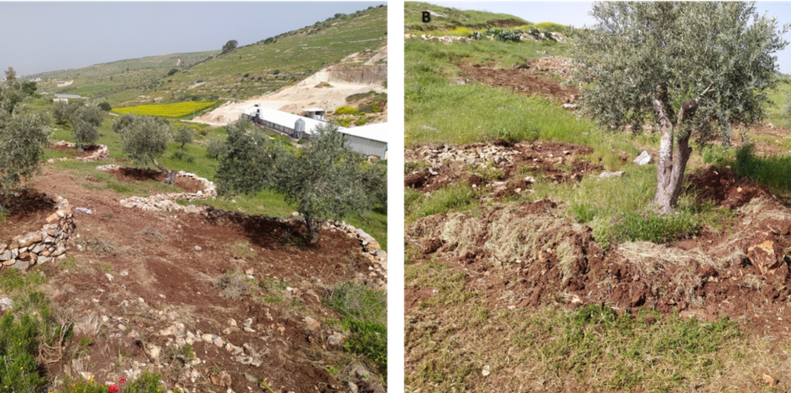
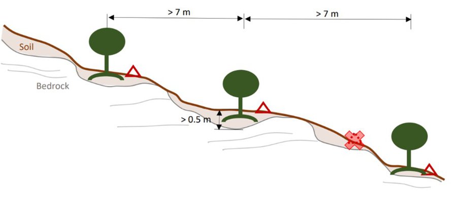
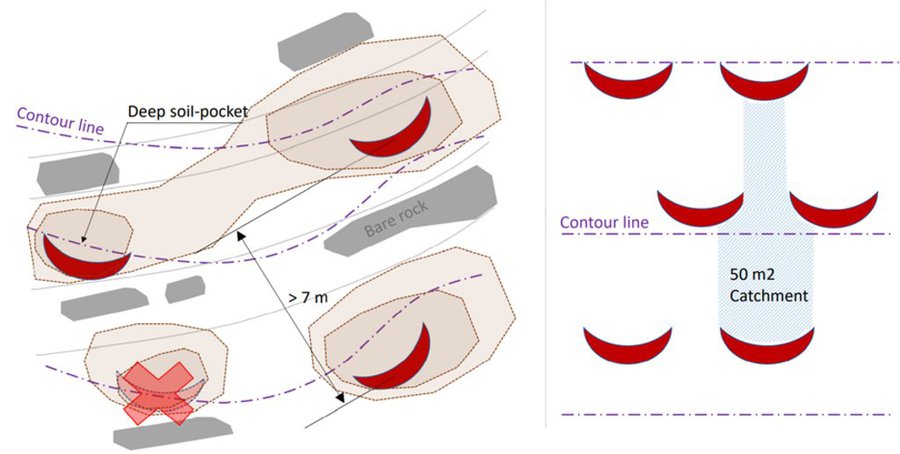
In Palestine, rainfed olives are traditionally cultivated within undulating landscapes with an average annual precipitation ranging between 400 and 700 mm. Olive trees are well known for their resilience to droughts. However, degraded and steeply sloping areas have limited water infiltration and storage capacity: a large proportion of rain forms surface runoff, further speeding up land degradation through erosion and the removal of fertile topsoil, leading to decreased soil health and productivity. The International Center of Agriculture Research in Dry Areas (ICARDA) among others, recognised these issues and superimposed microcatchment water harvesting structures on existing rainfed olive trees in marginal and degraded drylands of Palestine. This technique aims to improve yields by increasing soil moisture through capturing runoff and enhancing infiltration. Thereby, it also decreases the potential for land degradation through surface runoff. This has positive impacts on the local land users and land owners. These are often considered marginalised groups because they lack access to off-farm work and finance to invest in their farms. Additionally, these farmers are directly experiencing the negative impacts of climate change, such as more frequent droughts which can be linked to declining yields, and decreasing farm income. Depending on local climate, topographic and soil conditions, olive trees are usually spaced 5-10 meters apart to avoid competition for water.
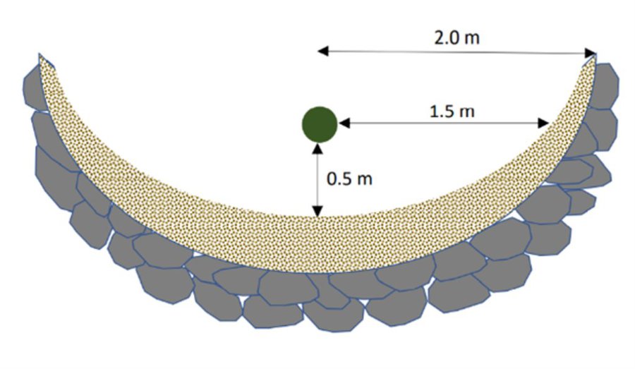
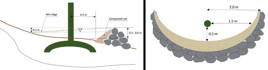
The land is first surveyed and then the microcatchment water harvesting structures (technically termed “semi-circular bunds”) are designed with the tips of the structures on the contour. They are constructed around 0.5 meters downslope of each olive tree in a semi-circle of around 4 meters diameter. The structures are created through stone foundation and bunds topped with a compacted soil layer. The height of the structures varies between 0.3 meters and 1.2 meters. As a first step, stones are placed and fixed in a semi-circular shape. Secondly, the soil inside the structure is slightly levelled. Thirdly, more stones are placed to heighten the bunds. Lastly, excavated and surround soil is put over the stones and thoroughly compacted. The estimation of establishment cost is 7 USD per meter of bund, implying a total cost of approximately 7000 USD per hectare.
The life-duration of the water harvesting system implemented in highly sloping areas, is estimated at 15 years with yearly maintenance cost estimated at 3 USD per tree – 300 USD per hectare. Without maintenance, the life-cycle of the system will be less.
Land users appreciate the technology because it improves their olive yields and thus income. They state that the topsoil maintained in situ, and the improved soil moisture, have positive effects on their harvest. Land users also acknowledge that implementing and maintaining increases the workload. Nevertheless, due to the local material requirements, the costs are low and thus perceived as positive.
Data presented in this documentation are partly made available under the project 'Testing and Out-scaling in situ Water Harvesting Technologies in Palestine' led by ICARDA in collaboration with the Applied Research Institute Jerusalem, Palestinian Ministry of Agriculture, and National Agricultural Research Centre in Palestine. The project is under the Food and Agriculture Organization of the United Nations (FAO) – a regional project “Implementing the 2030 Agenda for water efficiency/productivity and water sustainability in NENA countries” directly under the Regional Water Scarcity Initiative. The Swedish International Development Cooperation Agency funded the project.
Lieu
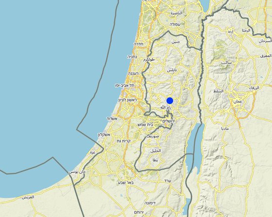
Lieu: Palestine
Nbr de sites de la Technologie analysés: site unique
Géo-référence des sites sélectionnés
Diffusion de la Technologie: répartie uniformément sur une zone (approx. 0,1-1 km2)
Dans des zones protégées en permanence ?: Non
Date de mise en oeuvre: 2021
Type d'introduction
-
grâce à l'innovation d'exploitants des terres
-
dans le cadre d'un système traditionnel (> 50 ans)
-
au cours d'expérimentations / de recherches
-
par le biais de projets/ d'interventions extérieures
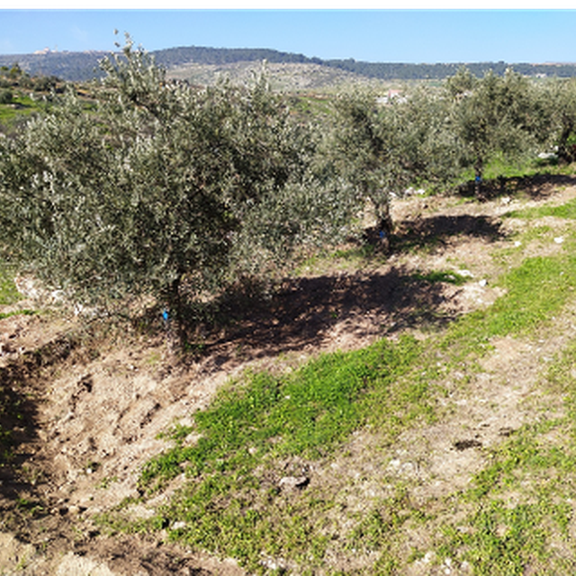
An older water harvesting structure (ARIJ)
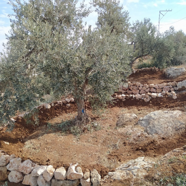
Freshly implemented water harvesting structure (ARIJ)
Classification de la Technologie
Principal objectif
-
améliorer la production
-
réduire, prévenir, restaurer les terres dégradées
-
préserver l'écosystème
-
protéger un bassin versant/ des zones situées en aval - en combinaison avec d'autres technologies
-
conserver/ améliorer la biodiversité
-
réduire les risques de catastrophes
-
s'adapter au changement et aux extrêmes climatiques et à leurs impacts
-
atténuer le changement climatique et ses impacts
-
créer un impact économique positif
-
créer un impact social positif
L'utilisation des terres
Les divers types d'utilisation des terres au sein du même unité de terrain: Non
-
Terres cultivées
- Plantations d’arbres ou de buissons: olive
Est-ce que les cultures intercalaires sont pratiquées? Non
Est-ce que la rotation des cultures est appliquée? Non
Approvisionnement en eau
-
pluvial
-
mixte: pluvial-irrigué
-
pleine irrigation
But relatif à la dégradation des terres
-
prévenir la dégradation des terres
-
réduire la dégradation des terres
-
restaurer/ réhabiliter des terres sévèrement dégradées
-
s'adapter à la dégradation des terres
-
non applicable
Dégradation des terres traité
-
érosion hydrique des sols - Wt: perte de la couche superficielle des sols (couche arable)/ érosion de surface, Wg: ravinement/ érosion en ravines, Wm: mouvements de masse/ glissements de terrain
-
érosion éolienne des sols - Et: perte de la couche superficielle des sols (couche arable)
Groupe de GDT
-
gestion des plantations forestières
-
mesures en travers de la pente
-
récupération/ collecte de l'eau
Mesures de GDT
-
structures physiques - S2: Diguettes, digues , S7: Collecte de l'eau/ approvisionnent en eau/ équipement d'irrigation
Dessin technique
Spécifications techniques
Microcatchment rainwater harvesting design, with detailed cross-sectional (left) and top (right) views; definition of dimensions
Microcatchment rainwater harvesting design in hillslope direction; definition of spacing constrained by the local ‘soil pocket’ hillslope pattern.
Microcatchment rainwater harvesting design from a top view; definition of minimum microcatchment areas contributing to the rainwater harvesting pits.
Microcatchment rainwater harvesting design, with detailed cross-sectional (left) and top (right) views; definition of dimensions.
Mise en œuvre et entretien : activités, intrants et coûts
Calcul des intrants et des coûts
- Les coûts sont calculés : par superficie de la Technologie (taille et unité de surface : 1 Hectare)
- Monnaie utilisée pour le calcul des coûts : dollars américains
- Taux de change (en dollars américains - USD) : 1 USD = n.d.
- Coût salarial moyen de la main-d'oeuvre par jour : n.d.
Facteurs les plus importants affectant les coûts
sans objet
Activités de mise en place/ d'établissement
-
Field survey for contours (Calendrier/ fréquence: None)
-
Place Stones (Calendrier/ fréquence: None)
-
Soil Removal (Calendrier/ fréquence: None)
-
Stone bund around tree (Calendrier/ fréquence: None)
-
Stone bund topped with excavated soil (Calendrier/ fréquence: None)
Coût total de mise en place (estimation)
7000,0
Activités récurrentes d'entretien
-
Incidental repairs (Calendrier/ fréquence: None)
Coût total d'entretien (estimation)
300,0
Environnement naturel
Précipitations annuelles
-
< 250 mm
-
251-500 mm
-
501-750 mm
-
751-1000 mm
-
1001-1500 mm
-
1501-2000 mm
-
2001-3000 mm
-
3001-4000 mm
-
> 4000 mm
Zones agro-climatiques
-
humide
-
subhumide
-
semi-aride
-
aride
Spécifications sur le climat
sans objet
Pentes moyennes
-
plat (0-2 %)
-
faible (3-5%)
-
modéré (6-10%)
-
onduleux (11-15%)
-
vallonné (16-30%)
-
raide (31-60%)
-
très raide (>60%)
Reliefs
-
plateaux/ plaines
-
crêtes
-
flancs/ pentes de montagne
-
flancs/ pentes de colline
-
piémonts/ glacis (bas de pente)
-
fonds de vallée/bas-fonds
Zones altitudinales
-
0-100 m
-
101-500 m
-
501-1000 m
-
1001-1500 m
-
1501-2000 m
-
2001-2500 m
-
2501-3000 m
-
3001-4000 m
-
> 4000 m
La Technologie est appliquée dans
-
situations convexes
-
situations concaves
-
non pertinent
Profondeurs moyennes du sol
-
très superficiel (0-20 cm)
-
superficiel (21-50 cm)
-
modérément profond (51-80 cm)
-
profond (81-120 cm)
-
très profond (>120 cm)
Textures du sol (de la couche arable)
-
grossier/ léger (sablonneux)
-
moyen (limoneux)
-
fin/ lourd (argile)
Textures du sol (> 20 cm sous la surface)
-
grossier/ léger (sablonneux)
-
moyen (limoneux)
-
fin/ lourd (argile)
Matière organique de la couche arable
-
abondant (>3%)
-
moyen (1-3%)
-
faible (<1%)
Profondeur estimée de l’eau dans le sol
-
en surface
-
< 5 m
-
5-50 m
-
> 50 m
Disponibilité de l’eau de surface
-
excès
-
bonne
-
moyenne
-
faible/ absente
Qualité de l’eau (non traitée)
-
eau potable
-
faiblement potable (traitement nécessaire)
-
uniquement pour usage agricole (irrigation)
-
eau inutilisable
La qualité de l'eau fait référence à: eaux de surface
La salinité de l'eau est-elle un problème ?
Présence d'inondations
Caractéristiques des exploitants des terres appliquant la Technologie
Orientation du système de production
-
subsistance (auto-approvisionnement)
-
exploitation mixte (de subsistance/ commerciale)
-
commercial/ de marché
Revenus hors exploitation
-
moins de 10% de tous les revenus
-
10-50% de tous les revenus
-
> 50% de tous les revenus
Niveau relatif de richesse
-
très pauvre
-
pauvre
-
moyen
-
riche
-
très riche
Niveau de mécanisation
-
travail manuel
-
traction animale
-
mécanisé/ motorisé
Sédentaire ou nomade
-
Sédentaire
-
Semi-nomade
-
Nomade
Individus ou groupes
-
individu/ ménage
-
groupe/ communauté
-
coopérative
-
employé (entreprise, gouvernement)
Âge
-
enfants
-
jeunes
-
personnes d'âge moyen
-
personnes âgées
Superficie utilisée par ménage
-
< 0,5 ha
-
0,5-1 ha
-
1-2 ha
-
2-5 ha
-
5-15 ha
-
15-50 ha
-
50-100 ha
-
100-500 ha
-
500-1 000 ha
-
1 000-10 000 ha
-
> 10 000 ha
Échelle
-
petite dimension
-
moyenne dimension
-
grande dimension
Propriété foncière
-
état
-
entreprise
-
communauté/ village
-
groupe
-
individu, sans titre de propriété
-
individu, avec titre de propriété
Droits d’utilisation des terres
-
accès libre (non organisé)
-
communautaire (organisé)
-
loué
-
individuel
Droits d’utilisation de l’eau
-
accès libre (non organisé)
-
communautaire (organisé)
-
loué
-
individuel
Accès aux services et aux infrastructures
emploi (par ex. hors exploitation)
eau potable et assainissement
Impact
Impacts socio-économiques
Production agricole
en baisse
en augmentation
qualité des cultures
en baisse
en augmentation
risque d'échec de la production
en augmentation
en baisse
Improved soil moisture provides resilience for droughts, reducing failure risk
gestion des terres
Not damaging the bunds may hinder land management
dépenses pour les intrants agricoles
en augmentation
en baisse
Inputs for repair and implementation is required
revenus agricoles
en baisse
en augmentation
Because soil moisture is increased, yield is as well and risk is decreased
charge de travail
en augmentation
en baisse
Building and repairing the bunds requires labour
Impacts socioculturels
sécurité alimentaire/ autosuffisance
connaissances sur la GDT/ dégradation des terres
Local farmers were included in the process, improving their knowledge
situation des groupes socialement et économiquement désavantagés (genre, âge, statut, ethnie, etc.)
Impacts écologiques
récolte/ collecte de l'eau (ruissellement, rosée, neige, etc.)
ruissellement de surface
en augmentation
en baisse
humidité du sol
en baisse
en augmentation
perte en sol
en augmentation
en baisse
accumulation de sol
en baisse
en augmentation
Impacts hors site
disponibilité de l’eau (nappes phréatiques, sources)
en baisse
en augmentation
inondations en aval (indésirables)
Analyse coûts-bénéfices
Bénéfices par rapport aux coûts de mise en place
Rentabilité à court terme
très négative
très positive
Rentabilité à long terme
très négative
très positive
Bénéfices par rapport aux coûts d'entretien
Rentabilité à court terme
très négative
très positive
Rentabilité à long terme
très négative
très positive
Changement climatique
Changements climatiques progressifs
précipitations annuelles décroît
pas bien du tout
très bien
Extrêmes climatiques (catastrophes)
pluie torrentielle locale
pas bien du tout
très bien
Adoption et adaptation de la Technologie
Pourcentage d'exploitants des terres ayant adopté la Technologie dans la région
-
cas isolés/ expérimentaux
-
1-10%
-
11-50%
-
> 50%
Parmi tous ceux qui ont adopté la Technologie, combien d'entre eux l'ont fait spontanément, à savoir sans recevoir aucune incitation matérielle ou aucun paiement ?
-
0-10%
-
11-50%
-
51-90%
-
91-100%
La Technologie a-t-elle été récemment modifiée pour s'adapter à l'évolution des conditions ?
A quel changement ?
-
changements/ extrêmes climatiques
-
évolution des marchés
-
la disponibilité de la main-d'œuvre (par ex., en raison de migrations)
Conclusions et enseignements tirés
Points forts: point de vue de l'exploitant des terres
-
Increased yield
-
Decreased land degradation
Points forts: point de vue du compilateur ou d'une autre personne-ressource clé
-
Reduced and reversed land degradation
-
Increased yield
Faiblesses/ inconvénients/ risques: point de vue de l'exploitant des terrescomment surmonter
-
Increases the workload
In the current state this cannot be overcome. However, alternative structures may be considered e.g., pre -fixed.
-
Limited availability of suitable stones
The purchase of stones or alternative materials such as wood or clay, or alternative structures such as pits.
Faiblesses/ inconvénients/ risques: point de vue du compilateur ou d'une autre personne-ressource clécomment surmonter
Références
Examinateur
-
William Critchley
-
Rima Mekdaschi Studer
Date de mise en oeuvre: 12 septembre 2022
Dernière mise à jour: 25 mai 2023
Personnes-ressources
-
Mira Haddad - Research Associate – Spatio-temporal assessment – Resilient Agrosilvopastoral Systems (RASP) – Restoration Initiative on Dryland Ecosystems (RIDE)
-
Stefan Strohmeier - Scientist, Soil and Water Conservation – Resilient Agrosilvopastoral Systems (RASP)
-
Vinay Nangia - Research Team Leader – Soils, Waters, and Agronomy
-
Boubaker Dhehibi - Senior Natural Resources Economist – Resilient Agrosilvopastoral Systems (RASP) – Social, Economic, and Policy Team (SEPT)
Description complète dans la base de données WOCAT
Données de GDT correspondantes
La documentation a été facilitée par
Institution
- International Center for Agricultural Research in the Dry Areas (ICARDA) - Liban
Projet
- ICARDA Institutional Knowledge Management Initiative
Références clés
-
Boubaker Dhehibi, Mira Haddad, Abdallah Alimari, Sameer Shadeed, Stefan Strohmeier, Issam Nofal, Anas Sayeh, Ibtisam I. O. AbuAlhaija, Mohammad Besharat, Imad Ghenma, Vinay Nangia. (6/3/2023). Potential Of Water Harvesting as a Strategic Tool for Resilience, Sustainable Livelihoods, and Drought Mitigation in the Olive Farming System in Palestine. Beirut, Lebanon: International Center for Agricultural Research in the Dry Areas (ICARDA).: https://hdl.handle.net/20.500.11766/68288