Cane and Bamboo Plantation to Sustain Raw Materials
(Bhoutan)
Ba Dang Pa Tshar Zuk Chong Bae Dhi Thoen Koed Yuen Ten Zho Ni (སྦ་དང་སྤ་ཚར་འཛུགས་སྐྱོང་འབད་དེ་ཐོན་སྐྱེད་ཡུན་བརྟན་བཟོ་ནི།)
Description
Cane and bamboo plantations are managed by land users and indigenous communities to sustain these valuable raw materials for making handicraft items. Tsharzo (bamboo craft), is one of the main sources of income for land users. Tsharzo makes use of cane and bamboo to weave products such as backpacks, baskets (for winnowing, for carrying fodder, fruits, shoots, etc.), and mats. These plantations are effective in conserving land and water.
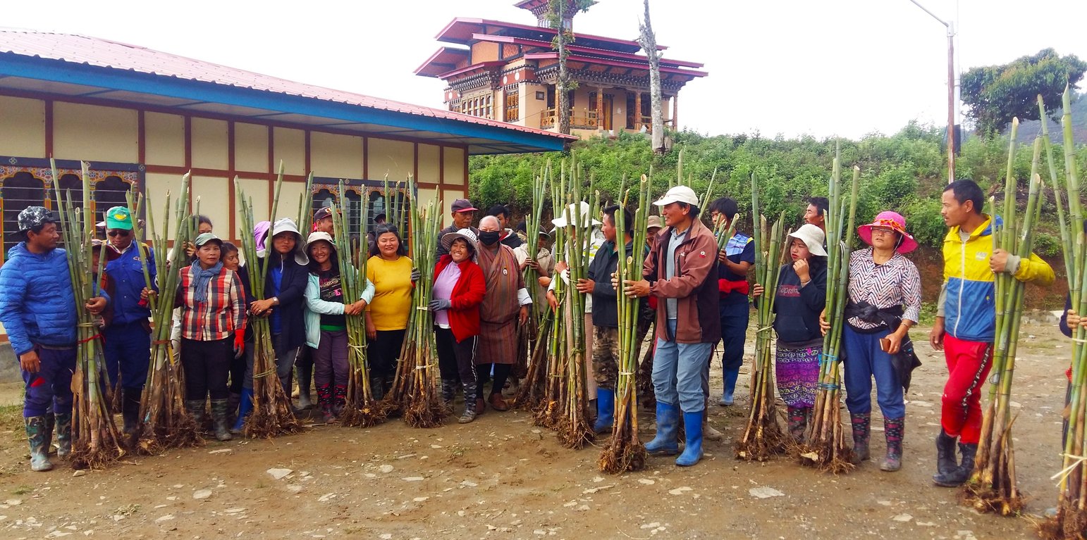
Tsharzo (bamboo craft), is one of the main sources of income, besides agriculture, for the land users of the Monpa community of Jangbi, Wangling, and Phrumzur in Trongsa. Tsharzo makes use of cane (“rattan”: Calamus spp.) and bamboo to weave products such as orongbhazib (backpacks), lapchu (hand baskets), chungchu (baskets), bechab (winnowing baskets), tsew (baskets to carry fodder, fruits, shoots etc.) and pari (mats). The technology of maintaining bamboo and cane plantations has been adopted by the land users to ensure a sustainable harvest of natural raw materials and to maintain germplasm for bamboo and cane. This helps to uphold ancestral arts and crafts skills, and to improve livelihoods.
Jangbi chiwog has 59 households (HH). The land users are members of Monpa Selwai Yoezer Tshogpa, a Community Forest Management Group which was formed to sustainably manage bamboo and cane resources, to preserve and promote age-old cane and bamboo handicraft skills and increase household income. The group is one of the most successful in promoting Tsharzo in the country. The group was formed under the United Nations Development Programme (UNDP) on 14 April 2000, and officially came into play in 2007, upon drafting bylaws. The bylaws were revised after the need for further improvement in the year 2018. The group received initial support from UNDP and Bhutan Orchids, a non-governmental organization (NGO). The government has given a total of 45 acres (18 ha) of land to the land users of Jangbi Chiwog to plant bamboo and cane. Out of the total, 15 acres (6 ha) are collectively managed as a nursery. About 10 acres (4 ha) are managed by each village as a plantation. The land users have planted three varieties of bamboo on the land.
The benefits of the technology include the establishment of dedicated germplasm for bamboo and cane, sustainable harvest of natural raw materials, conservation and promotion of ancestral arts and crafts skills, social cohesion through group formation, and employment opportunities.
Bamboo and cane plantations play a great role in preventing soil degradation. Bamboo and cane have extensive root systems that help prevent erosion, stabilize soil, and reduce landslide risks. They are excellent for revegetation as they quickly establish themselves. Bamboo is also an efficient carbon sink, absorbing significant amounts of carbon dioxide from the atmosphere. This helps mitigate climate change by reducing greenhouse gas concentrations. Bamboo and cane provide habitats for various organisms thereby increasing biodiversity. Products made from bamboo and cane are biodegradable, minimizing any potential environmental impact.
Lieu
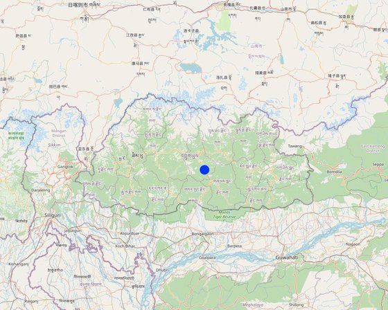
Lieu: Jangbi, Wangling and Phrumzur villages under Jangbi Chiwog, Langthel gewog, Trongsa Dzongkhag, Bhoutan
Nbr de sites de la Technologie analysés: site unique
Géo-référence des sites sélectionnés
Diffusion de la Technologie: répartie uniformément sur une zone (18.2 km²)
Dans des zones protégées en permanence ?: Oui
Date de mise en oeuvre: 2000
Type d'introduction
-
grâce à l'innovation d'exploitants des terres
-
dans le cadre d'un système traditionnel (> 50 ans)
-
au cours d'expérimentations / de recherches
-
par le biais de projets/ d'interventions extérieures
Bamboo planted in a farmer's field (Kuenzang Nima)
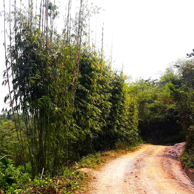
Bamboo planted along the farm roadside for stabilization and domestic use. (Haka Drukpa)
Classification de la Technologie
Principal objectif
-
améliorer la production
-
réduire, prévenir, restaurer les terres dégradées
-
préserver l'écosystème
-
protéger un bassin versant/ des zones situées en aval - en combinaison avec d'autres technologies
-
conserver/ améliorer la biodiversité
-
réduire les risques de catastrophes
-
s'adapter au changement et aux extrêmes climatiques et à leurs impacts
-
atténuer le changement climatique et ses impacts
-
créer un impact économique positif
-
créer un impact social positif
L'utilisation des terres
Les divers types d'utilisation des terres au sein du même unité de terrain: Non
Approvisionnement en eau
-
pluvial
-
mixte: pluvial-irrigué
-
pleine irrigation
But relatif à la dégradation des terres
-
prévenir la dégradation des terres
-
réduire la dégradation des terres
-
restaurer/ réhabiliter des terres sévèrement dégradées
-
s'adapter à la dégradation des terres
-
non applicable
Dégradation des terres traité
-
érosion hydrique des sols - Wt: perte de la couche superficielle des sols (couche arable)/ érosion de surface, Wg: ravinement/ érosion en ravines, Wm: mouvements de masse/ glissements de terrain
-
érosion éolienne des sols - Et: perte de la couche superficielle des sols (couche arable)
-
dégradation biologique - Bc: réduction de la couverture végétale, Bq: baisse de la quantité/ biomasse
Groupe de GDT
-
gestion des forêts naturelles et semi-naturelles
-
gestion des plantations forestières
Mesures de GDT
-
pratiques végétales - V1: Couverture d’arbres et d’arbustes
-
structures physiques - S6: Murs, barrières, palissades, clôtures
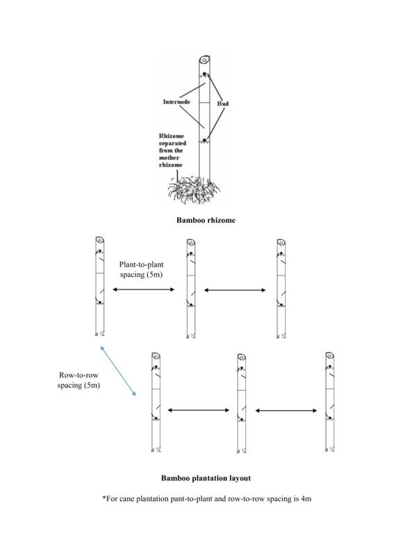
Dessin technique
Spécifications techniques
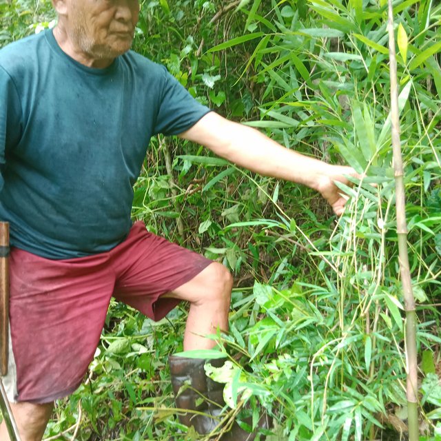
The bamboos thriving in the wild are documented in the community. They are an important source of raw materials for producing bamboo products.
Author: Tshering Yangzom
Mise en œuvre et entretien : activités, intrants et coûts
Calcul des intrants et des coûts
- Les coûts sont calculés : par superficie de la Technologie (taille et unité de surface : 45 acres; facteur de conversion pour un hectare : 1 ha = 45 acres = 18.2 ha)
- Monnaie utilisée pour le calcul des coûts : Nu.
- Taux de change (en dollars américains - USD) : 1 USD = 82.0 Nu.
- Coût salarial moyen de la main-d'oeuvre par jour : n.d.
Facteurs les plus importants affectant les coûts
sans objet
Activités de mise en place/ d'établissement
-
Attempted to commercialize bamboo and cane products through market exploration (contract) by a few households. (Calendrier/ fréquence: 2000)
-
Gewog and the Forest Office collaboratively explored funds to help the communities. (Calendrier/ fréquence: 2000)
-
Funds sourced from UNDP. The land users were sensitized. (Calendrier/ fréquence: 2000 (summer-during paddy season))
-
The land users were trained on plantations and product development. (Calendrier/ fréquence: 2000)
-
Land users (12 of them) were taken on an exposure tour to India. (Calendrier/ fréquence: 2000)
Coût total de mise en place (estimation)
2200000,0
Activités récurrentes d'entretien
n.a.
Coût total d'entretien (estimation)
20000,0
Environnement naturel
Précipitations annuelles
-
< 250 mm
-
251-500 mm
-
501-750 mm
-
751-1000 mm
-
1001-1500 mm
-
1501-2000 mm
-
2001-3000 mm
-
3001-4000 mm
-
> 4000 mm
Zones agro-climatiques
-
humide
-
subhumide
-
semi-aride
-
aride
Spécifications sur le climat
The rain estimate has been derived based on the agro-ecological zone (AEZ) the area falls under. Bhutan is divided into six AEZs (source: https://www.fao.org/3/ad103e/AD103E02.htm).
The site is about 1500 masl. It falls under Dry-Subtropical Zone. Bhutan has six AEZs. The wet sub-tropical zone is from 150 to 600 m, followed by the humid sub-tropical zone from 600 to 1,200 m. The dry sub-tropical zone starts at 1,200 m and extends to 1,800 m, followed by the warm temperate zone, which reaches 2,600 m. The cool temperate zone lies between 2,600 and 3,600 m and, finally, the alpine zone between 3,600 m and 4,600 m.
https://www.fao.org/3/ad103e/AD103E02.htm
Pentes moyennes
-
plat (0-2 %)
-
faible (3-5%)
-
modéré (6-10%)
-
onduleux (11-15%)
-
vallonné (16-30%)
-
raide (31-60%)
-
très raide (>60%)
Reliefs
-
plateaux/ plaines
-
crêtes
-
flancs/ pentes de montagne
-
flancs/ pentes de colline
-
piémonts/ glacis (bas de pente)
-
fonds de vallée/bas-fonds
Zones altitudinales
-
0-100 m
-
101-500 m
-
501-1000 m
-
1001-1500 m
-
1501-2000 m
-
2001-2500 m
-
2501-3000 m
-
3001-4000 m
-
> 4000 m
La Technologie est appliquée dans
-
situations convexes
-
situations concaves
-
non pertinent
Profondeurs moyennes du sol
-
très superficiel (0-20 cm)
-
superficiel (21-50 cm)
-
modérément profond (51-80 cm)
-
profond (81-120 cm)
-
très profond (>120 cm)
Textures du sol (de la couche arable)
-
grossier/ léger (sablonneux)
-
moyen (limoneux)
-
fin/ lourd (argile)
Textures du sol (> 20 cm sous la surface)
-
grossier/ léger (sablonneux)
-
moyen (limoneux)
-
fin/ lourd (argile)
Matière organique de la couche arable
-
abondant (>3%)
-
moyen (1-3%)
-
faible (<1%)
Profondeur estimée de l’eau dans le sol
-
en surface
-
< 5 m
-
5-50 m
-
> 50 m
Disponibilité de l’eau de surface
-
excès
-
bonne
-
moyenne
-
faible/ absente
Qualité de l’eau (non traitée)
-
eau potable
-
faiblement potable (traitement nécessaire)
-
uniquement pour usage agricole (irrigation)
-
eau inutilisable
La qualité de l'eau fait référence à: eaux de surface
La salinité de l'eau est-elle un problème ?
Présence d'inondations
Caractéristiques des exploitants des terres appliquant la Technologie
Orientation du système de production
-
subsistance (auto-approvisionnement)
-
exploitation mixte (de subsistance/ commerciale)
-
commercial/ de marché
Revenus hors exploitation
-
moins de 10% de tous les revenus
-
10-50% de tous les revenus
-
> 50% de tous les revenus
Niveau relatif de richesse
-
très pauvre
-
pauvre
-
moyen
-
riche
-
très riche
Niveau de mécanisation
-
travail manuel
-
traction animale
-
mécanisé/ motorisé
Sédentaire ou nomade
-
Sédentaire
-
Semi-nomade
-
Nomade
Individus ou groupes
-
individu/ ménage
-
groupe/ communauté
-
coopérative
-
employé (entreprise, gouvernement)
Âge
-
enfants
-
jeunes
-
personnes d'âge moyen
-
personnes âgées
Superficie utilisée par ménage
-
< 0,5 ha
-
0,5-1 ha
-
1-2 ha
-
2-5 ha
-
5-15 ha
-
15-50 ha
-
50-100 ha
-
100-500 ha
-
500-1 000 ha
-
1 000-10 000 ha
-
> 10 000 ha
Échelle
-
petite dimension
-
moyenne dimension
-
grande dimension
Propriété foncière
-
état
-
entreprise
-
communauté/ village
-
groupe
-
individu, sans titre de propriété
-
individu, avec titre de propriété
-
Family land
Droits d’utilisation des terres
-
accès libre (non organisé)
-
communautaire (organisé)
-
loué
-
individuel
Droits d’utilisation de l’eau
-
accès libre (non organisé)
-
communautaire (organisé)
-
loué
-
individuel
Accès aux services et aux infrastructures
emploi (par ex. hors exploitation)
eau potable et assainissement
Impact
Impacts socio-économiques
production forestière non ligneuse
en baisse
en augmentation
Quantité avant la GDT: 50 - 60 products in a year
Quantité après la GDT: 10 - 15 products in a year
The non-wood forest production has increased due to sustainable plantation, but the number of products developed using the raw materials has decreased. But again, the income has increased. In the earlier years, a household would earn about Nu.10000 by selling 50 - 60 products, whereas a household now earns a minimum of Nu. 25000 by selling 10 - 15 products due to higher prices of the products.
surface de production (nouvelles terres cultivées/ utilisées)
en baisse
en augmentation
Quantité avant la GDT: None
Quantité après la GDT: 18.2 ha
With the initiation of bamboo and cane germplasm, the production area has increased and the source of raw materials for the community is sustained. Before the land users were given 18.2 ha by the government, the land users collected cane and bamboo from the forest to make products.
gestion des terres
The bamboo and cane plantations have prevented soil erosion and stabilized the lands.
diversité des sources de revenus
en baisse
en augmentation
The income earned from products sold in the market adds to the annual income of the family.
Impacts socioculturels
sécurité alimentaire/ autosuffisance
The higher annual income generation from the sale of bamboo and cane products has assured food security in some ways.
situation sanitaire
Better income and diet have resulted in better health.
connaissances sur la GDT/ dégradation des terres
The role of plantations in mitigating land degradation is well-instilled in the land users. They now even carry out bamboo plantations along the peripheries of newly constructed roads to stabilize the soil faster.
apaisement des conflits
There is equity in the harvest of raw materials.
situation des groupes socialement et économiquement désavantagés (genre, âge, statut, ethnie, etc.)
The land users have been able to improve their livelihood through sustainable management of bamboo and cane and the sale of the finished products.
Impacts écologiques
couverture végétale
en baisse
en augmentation
The vegetation cover has increased due to the plantation.
biomasse/ au dessus du sol C
en baisse
en augmentation
The biomass has increased due to the increase in vegetation cover.
Analyse coûts-bénéfices
Bénéfices par rapport aux coûts de mise en place
Rentabilité à court terme
très négative
très positive
Rentabilité à long terme
très négative
très positive
Bénéfices par rapport aux coûts d'entretien
Rentabilité à court terme
très négative
très positive
Rentabilité à long terme
très négative
très positive
Changement climatique
Changements climatiques progressifs
températures annuelles augmente
pas bien du tout
très bien
Extrêmes climatiques (catastrophes)
pluie torrentielle locale
pas bien du tout
très bien
pas bien du tout
très bien
pas bien du tout
très bien
pas bien du tout
très bien
pas bien du tout
très bien
pas bien du tout
très bien
Adoption et adaptation de la Technologie
Pourcentage d'exploitants des terres ayant adopté la Technologie dans la région
-
cas isolés/ expérimentaux
-
1-10%
-
11-50%
-
> 50%
Parmi tous ceux qui ont adopté la Technologie, combien d'entre eux l'ont fait spontanément, à savoir sans recevoir aucune incitation matérielle ou aucun paiement ?
-
0-10%
-
11-50%
-
51-90%
-
91-100%
Nombre de ménages et/ou superficie couverte
59 HH are part of Monpa Selwai Yoezer Tshogpa
La Technologie a-t-elle été récemment modifiée pour s'adapter à l'évolution des conditions ?
A quel changement ?
-
changements/ extrêmes climatiques
-
évolution des marchés
-
la disponibilité de la main-d'œuvre (par ex., en raison de migrations)
Conclusions et enseignements tirés
Points forts: point de vue de l'exploitant des terres
-
Preserve and promote ancestral arts and crafts skills.
-
Maintain germplasm for bamboo and cane. The raw materials for future use are assured due to the establishment of a 45-acre germplasm.
-
Generate income through the sale of bamboo and cane products.
-
Sustainable harvest of natural raw materials
Points forts: point de vue du compilateur ou d'une autre personne-ressource clé
-
Higher vegetation cover.
-
Prevent land degradation (bamboo and cane have extensive root systems that help prevent erosion, stabilize soil, and reduce landslide risks).
-
Sustainable utilization of forest resources (bamboo and cane).
-
Diversify income sources of the land users.
-
Social cohesion through collaboration and coordination among the land users.
Faiblesses/ inconvénients/ risques: point de vue de l'exploitant des terrescomment surmonter
-
The identified germplasm area lacks suitable places for convenient plantations. The majority of the area is rugged terrain and steep.
Exclude the steep and rugged terrains. Explore and identify suitable and more convenient areas for plantation.
-
The wooden fencing poles surrounding the germplasm area are not durable (cannot withstand barbed wires for longer periods).
Replace the wooden fencing poles with steel posts or other durable materials.
-
No funds to scale up. For instance, the canes lost in the 2017 forest fire have not been re-generated like bamboo.
Additional funds are to be sought to scale up the plantation programs.
Faiblesses/ inconvénients/ risques: point de vue du compilateur ou d'une autre personne-ressource clécomment surmonter
-
No funds to scale up.
Provision of funds by relevant stakeholders.
-
Risk of fire.
The Department of Forests and Park Services had initiated Interagency Forest Fire Coordination Group (IFFCG) at Dzongkhag and Gewog level to mitigate fire with involvement of Dzongkhag, Gewogs and relevant agencies. The IFFCG is headed by Dasho Dzongda and the Dzongkhag disaster management committee in coordination with relevant agency are responsible for mitigation and preventing the fire and provide necessary support to the affected individual or community. Several awareness programs and hands on training on fire mitigation and prevention was also provided to the communities by the Department of Forests and Park Services.
Références
Examinateur
-
William Critchley
-
Rima Mekdaschi Studer
-
Joana Eichenberger
Date de mise en oeuvre: 17 juillet 2023
Dernière mise à jour: 30 mai 2024
Personnes-ressources
-
Sonam - exploitant des terres
-
Nagari - exploitant des terres
-
Chencho - exploitant des terres
-
Lethro - exploitant des terres
Description complète dans la base de données WOCAT
Données de GDT correspondantes
La documentation a été facilitée par
Institution
- National Soil Services Center, Department of Agric (National Soil Services Center, Department of Agric) - Bhoutan
Projet
- Strengthening national-level institutional and professional capacities of country Parties towards enhanced UNCCD monitoring and reporting – GEF 7 EA Umbrella II (GEF 7 UNCCD Enabling Activities_Umbrella II)
Liens vers des informations pertinentes disponibles en ligne