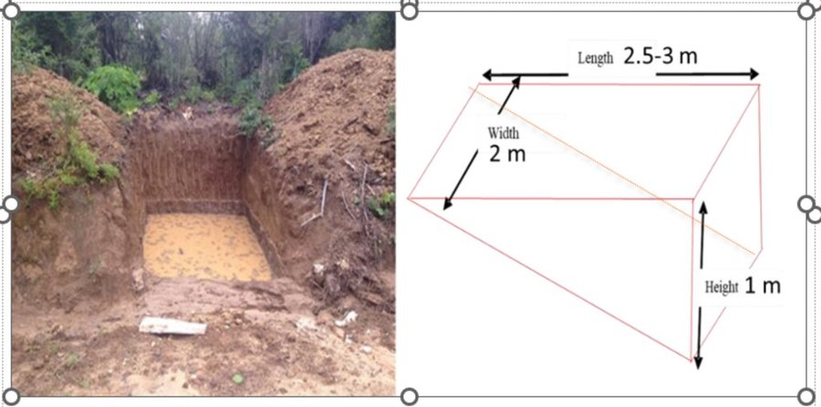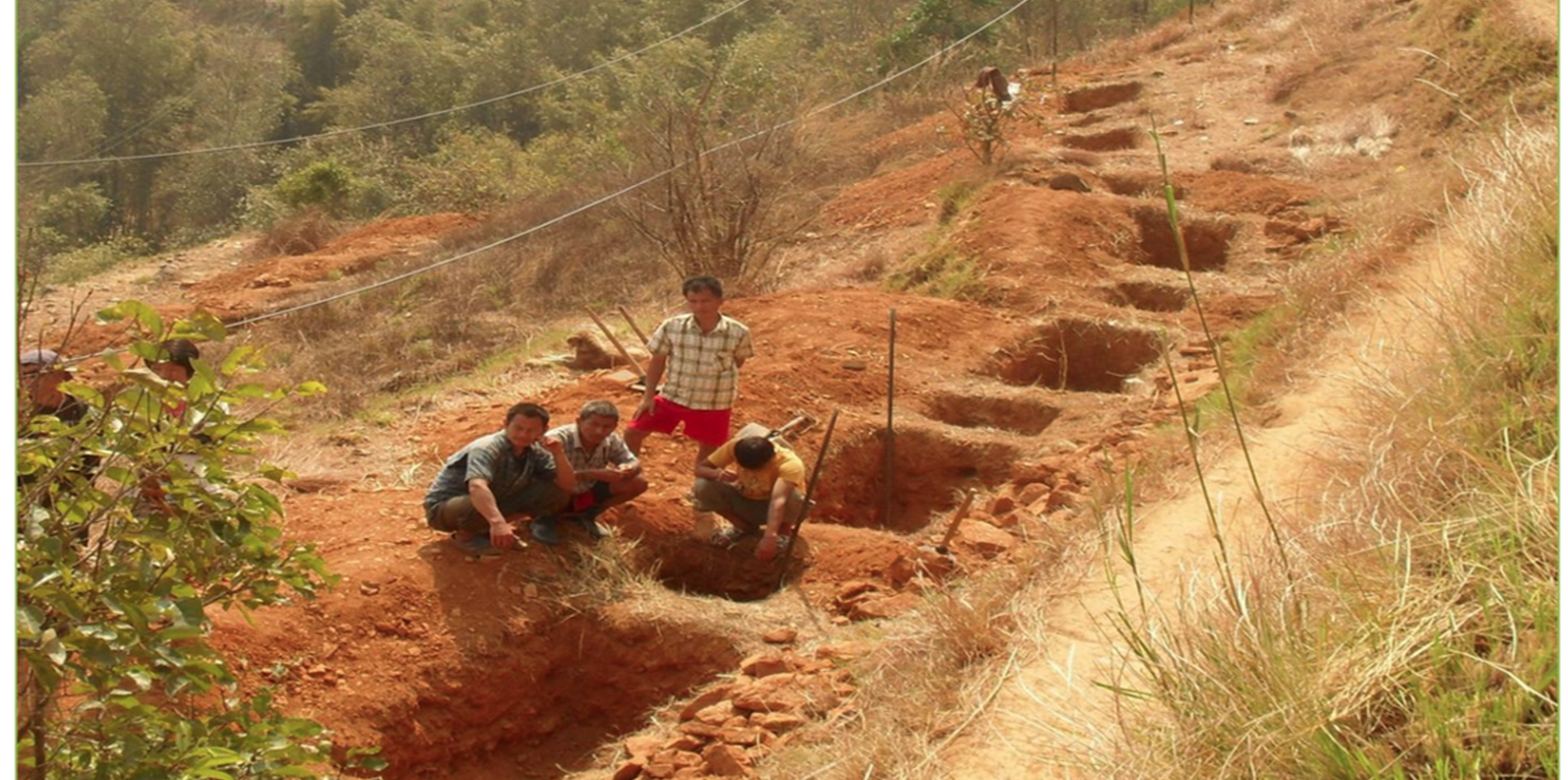
This is a trenches build to check the spring water flow and the water is stored in a pond . (Tshering Gyeltshen)

Springshed Revival through Trenches and Checkdams (Bhoutan)

Sa Hoka Koni Dang Tsip Chabtey Chhuka Sa Khong Nyam Soong (ས་ཧོག་ཀ་བརྐོ་ནི་དང་རྩིགཔ་རྐྱབ་སྟེ་ཆུ་རྐ་ས་ཁོངས་ཉམས་སྲུང་།)

Description

Springshed revival through trenches and check dams is associated with a nature-based solution approach to reviving more than 20 springsheds. These were widened with the occasional construction of check dams to prevent rill erosion from the newly revived spring waters.

Trenches and check dams play a vital role in the implementation of the springshed revival technology in the picturesque hilly village of Lholing. This innovative approach to rejuvenating springsheds has extended its reach from the lush pasturelands above the village all the way down to the very first household of Lholing, resulting in the construction of approximately 20 ponds of varying sizes, replenished by springsheds. In some instances, the creation and expansion of these springsheds required the utilisation of mechanical excavators, emphasising the magnitude of the project.
The revitalised springsheds now produce an array of springs, each contributing water that eventually converges into a common tributary meandering towards the village. This valuable water is collected and stored in purposefully constructed water harvesting ponds, serving as a reliable source for kitchen garden irrigation and cattle feeding. While the primary objective was to address the pressing issue of drinking water scarcity in the community, it also yielded secondary benefits. These encompassed the provision of a drinking water source for the wildlife inhabiting the area, as well as supporting the irrigation needs of the kitchen garden. The implementation of check dams yielded additional advantages by mitigating rill and gully erosion and serving as effective filters for muddy spring water. This sustainable land management strategy was accomplished through a series of distinct activities. Firstly, an exhaustive survey and assessment of the springshed area was conducted to identify suitable locations for trenches and check dams. This process took into account factors such as the topography of the terrain, the hydrological dynamics, and the composition of the soil. Subsequently, a comprehensive plan and design was developed for the trenches and check dams, including their dimensions, spacing, and alignment. The involvement of experts and stakeholders during this stage ensured that the chosen design was optimal in terms of its effectiveness (Sameul, 2008).

The execution phase involved the excavation and shaping of the trenches according to the design, followed by the construction of check dams. Trenching are required in open areas (where there is no vegetation cover) to trap surface runoff and enhance infiltration. Trenches can be dug along contour lines in a staggered or continuous pattern. However, the size of the trench is determined based on the site conditions. The number of trenches/pits depends on size, annual precipitation and the slope gradient of the recharge area in smaller area. Wedge shaped trenches are recommended for open areas while staggered or continuous trenches are recommended on slopy areas. Trenches are recommended in larger open area, while pits these check dams were specifically devised to retain water and control its flow. As part of gully treatment and to increase water infiltration, check dams are constructed. Typically, walls or barriers were built using locally available materials such as stone, wood, or concrete.

The advantages and benefits derived from this technology are manifold. In addition to the aforementioned advantages associated with springsheds, the implementation of trenches and check dams significantly contributed to the preservation and conservation of the fertile topsoil, preventing its degradation and erosion. The land users in the village expressed contentment with the successful revival of the springsheds, recognising their multifaceted contributions. Furthermore, they were duly impressed by the check dams' efficacy in preventing soil erosion and their ability to filter muddy water, ensuring a reliable and clean water supply (RSPN, 2023).
The creation of the ponds was especially appreciated as they served as a convenient water source for grazing cattle in the nearby jungle. However, despite the numerous benefits, there was a sense of dissatisfaction among many villagers due to the increasing number of wild animals, including wild boar and deer that frequented the ponds to quench their thirst. This unexpected influx of wildlife posed a significant threat to farms located in close proximity to the open springsheds.
Lieu

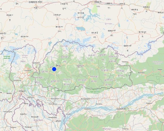
Lieu: Shaba, Lholing., Paro, Bhoutan

Nbr de sites de la Technologie analysés: 10-100 sites

Géo-référence des sites sélectionnés
  • 89.50238, 27.36699

Diffusion de la Technologie: appliquée en des points spécifiques ou concentrée sur une petite surface

Dans des zones protégées en permanence ?: Non

Date de mise en oeuvre: 2017; il y a moins de 10 ans (récemment)

Type d'introduction
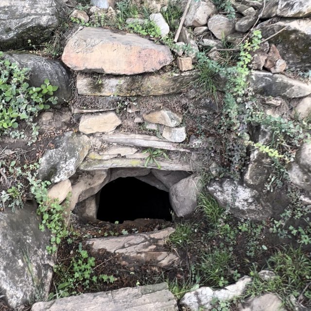
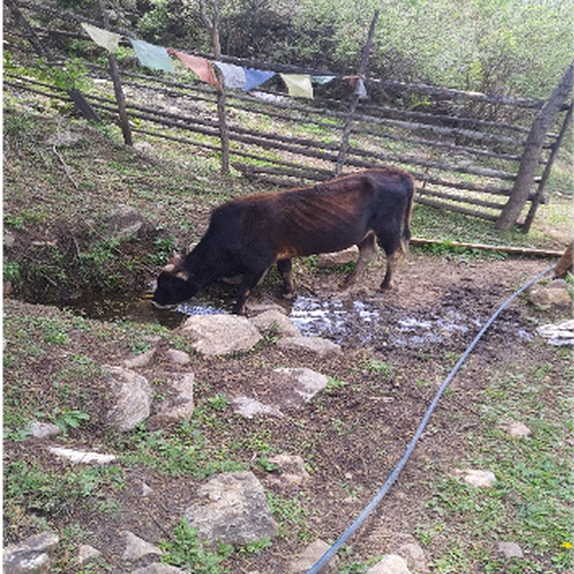
The photo displays one of the springshed revived through check dams. (Tshering Gyeltshen)
Revived springshed provide drinking water to local communities and livestock (Thinley Tshering)

Classification de la Technologie

Principal objectif
  • améliorer la production
  • réduire, prévenir, restaurer les terres dégradées
  • préserver l'écosystème
  • protéger un bassin versant/ des zones situées en aval - en combinaison avec d'autres technologies
  • conserver/ améliorer la biodiversité
  • réduire les risques de catastrophes
  • s'adapter au changement et aux extrêmes climatiques et à leurs impacts
  • atténuer le changement climatique et ses impacts
  • créer un impact économique positif
  • créer un impact social positif
  • To find another alternative source of water for cattle, laundry and other washing alternatives.
L'utilisation des terres
Les divers types d'utilisation des terres au sein du même unité de terrain: Non

  • Terres cultivées
    • Cultures annuelles: céréales - riz (de terres humides)
    Nombre de période de croissance par an: : 1
    Est-ce que les cultures intercalaires sont pratiquées? Oui
    Est-ce que la rotation des cultures est appliquée? Oui
  • Pâturages
    • Ranching
    • Affouragement en vert/ zéro-pâturage
    Type d'animal: bétail - laitier
    Est-ce que la gestion intégrée cultures-élevage est pratiquée? Oui
      EspècesCount
      bétail - laitiersans objet
    • Voies d'eau, plans d'eau, zones humides - Etangs, barrages, retenues d'eau, Marécages, zones humides
      Principaux produits/ services: Many small patches of wetlands are there.
    Approvisionnement en eau
    • pluvial
    • mixte: pluvial-irrigué
    • pleine irrigation

    But relatif à la dégradation des terres
    • prévenir la dégradation des terres
    • réduire la dégradation des terres
    • restaurer/ réhabiliter des terres sévèrement dégradées
    • s'adapter à la dégradation des terres
    • non applicable
    Dégradation des terres traité
    • érosion hydrique des sols - Wt: perte de la couche superficielle des sols (couche arable)/ érosion de surface
    • dégradation hydrique - Hq: baisse de la qualité des eaux souterraines
    Groupe de GDT
    • récupération/ collecte de l'eau
    • gestion des eaux de surface (sources, rivières, lacs, mers)
    • gestion des eaux souterraines
    Mesures de GDT
    • structures physiques - S2: Diguettes, digues , S4: Fossés isohypses, trous, S7: Collecte de l'eau/ approvisionnent en eau/ équipement d'irrigation

    Dessin technique

    Spécifications techniques
    Design for the trenches as adapted from spring revival pilot site at Lholing, Paro
    Author: Water management Division

    Mise en œuvre et entretien : activités, intrants et coûts

    Calcul des intrants et des coûts
    • Les coûts sont calculés : par entité de la Technologie
    • Monnaie utilisée pour le calcul des coûts : Bhutanese Currency (Ngultrum)
    • Taux de change (en dollars américains - USD) : 1 USD = 82.25 Bhutanese Currency (Ngultrum)
    • Coût salarial moyen de la main-d'oeuvre par jour : 700
    Facteurs les plus importants affectant les coûts
    The most important factor that contributed to the huge cost was from machine hiring charges. The community usually cost minimum of Nu. 15000 in an hour and some of them can hire it counting the number of days.
    Activités de mise en place/ d'établissement
    1. conducting a thorough survey and assessment in spring shed area (Calendrier/ fréquence: -)
    2. Develop a comprehensive plan and design for the check dams and trenches. (Calendrier/ fréquence: -)
    3. Gathering of labor and constructing materials. (Calendrier/ fréquence: -)
    4. Excavate the trenches according to the planned design and shape the trenches to facilitate proper water flow and retention. (Calendrier/ fréquence: started in March)
    5. Build check dams across the trenches to impound water and control its flow. (Calendrier/ fréquence: -)
    6. Install the check dams in the designated locations along the trenches and ensure proper alignment and stability of the structures (Calendrier/ fréquence: -)
    7. Regularly monitor the check dams and trenches for any signs of damage or erosion. (Calendrier/ fréquence: -)
    Intrants et coûts de mise en place
    Spécifiez les intrants Unité Quantité Coûts par unité (Bhutanese Currency (Ngultrum)) Coût total par intrant (Bhutanese Currency (Ngultrum)) % des coût supporté par les exploitants des terres
    Main d'œuvre
    labour person 22,0 700,0 15400,0
    Technical Person (Forester) person 8,0 1500,0 12000,0
    Equipements
    Excavator number 1,0 15000,0 15000,0
    Barbed wire meter 2,0 5500,0 11000,0
    Tarpauline sheet meter 2,0 4200,0 8400,0
    Matériaux de construction
    Mud
    Boulders
    Coût total de mise en place de la Technologie 61'800.0
    Coût total de mise en place de la Technologie en dollars américains (USD) 751.37
    Activités récurrentes d'entretien
    1. Farmers Gathering (Calendrier/ fréquence: Thrice (spring, Summer, winter))
    2. visiting each of the constructed site and they removed the sedimented particles in the trenches. (Calendrier/ fréquence: Thrice( before onset of monsoon season)
    3. Substituting the worn out plastic if in case it was damaged (Calendrier/ fréquence: once)
    Intrants et coûts de l'entretien
    Spécifiez les intrants Unité Quantité Coûts par unité (Bhutanese Currency (Ngultrum)) Coût total par intrant (Bhutanese Currency (Ngultrum)) % des coût supporté par les exploitants des terres
    Main d'œuvre
    Farmers person 22,0 100,0
    Equipements
    spade and shovel numbers 10,0 100,0

    Environnement naturel

    Précipitations annuelles
    • < 250 mm
    • 251-500 mm
    • 501-750 mm
    • 751-1000 mm
    • 1001-1500 mm
    • 1501-2000 mm
    • 2001-3000 mm
    • 3001-4000 mm
    • > 4000 mm
    Zones agro-climatiques
    • humide
    • subhumide
    • semi-aride
    • aride
    Spécifications sur le climat
    The area experienced low rainfall being in the cool temperate region.
    Nom de la station météorologique : Weather station, Paro
    The area falls on Cool Temperate region as per the Agro-ecological Zones of Bhutan
    Pentes moyennes
    • plat (0-2 %)
    • faible (3-5%)
    • modéré (6-10%)
    • onduleux (11-15%)
    • vallonné (16-30%)
    • raide (31-60%)
    • très raide (>60%)
    Reliefs
    • plateaux/ plaines
    • crêtes
    • flancs/ pentes de montagne
    • flancs/ pentes de colline
    • piémonts/ glacis (bas de pente)
    • fonds de vallée/bas-fonds
    Zones altitudinales
    • 0-100 m
    • 101-500 m
    • 501-1000 m
    • 1001-1500 m
    • 1501-2000 m
    • 2001-2500 m
    • 2501-3000 m
    • 3001-4000 m
    • > 4000 m
    La Technologie est appliquée dans
    • situations convexes
    • situations concaves
    • non pertinent
    Profondeurs moyennes du sol
    • très superficiel (0-20 cm)
    • superficiel (21-50 cm)
    • modérément profond (51-80 cm)
    • profond (81-120 cm)
    • très profond (>120 cm)
    Textures du sol (de la couche arable)
    • grossier/ léger (sablonneux)
    • moyen (limoneux)
    • fin/ lourd (argile)
    Textures du sol (> 20 cm sous la surface)
    • grossier/ léger (sablonneux)
    • moyen (limoneux)
    • fin/ lourd (argile)
    Matière organique de la couche arable
    • abondant (>3%)
    • moyen (1-3%)
    • faible (<1%)
    Profondeur estimée de l’eau dans le sol
    • en surface
    • < 5 m
    • 5-50 m
    • > 50 m
    Disponibilité de l’eau de surface
    • excès
    • bonne
    • moyenne
    • faible/ absente
    Qualité de l’eau (non traitée)
    • eau potable
    • faiblement potable (traitement nécessaire)
    • uniquement pour usage agricole (irrigation)
    • eau inutilisable
    La qualité de l'eau fait référence à: à la fois les eaux souterraines et de surface
    La salinité de l'eau est-elle un problème ?
    • Oui
    • Non

    Présence d'inondations
    • Oui
    • Non
    Diversité des espèces
    • élevé
    • moyenne
    • faible
    Diversité des habitats
    • élevé
    • moyenne
    • faible

    Caractéristiques des exploitants des terres appliquant la Technologie

    Orientation du système de production
    • subsistance (auto-approvisionnement)
    • exploitation mixte (de subsistance/ commerciale)
    • commercial/ de marché
    Revenus hors exploitation
    • moins de 10% de tous les revenus
    • 10-50% de tous les revenus
    • > 50% de tous les revenus
    Niveau relatif de richesse
    • très pauvre
    • pauvre
    • moyen
    • riche
    • très riche
    Niveau de mécanisation
    • travail manuel
    • traction animale
    • mécanisé/ motorisé
    Sédentaire ou nomade
    • Sédentaire
    • Semi-nomade
    • Nomade
    Individus ou groupes
    • individu/ ménage
    • groupe/ communauté
    • coopérative
    • employé (entreprise, gouvernement)
    Genre
    • femmes
    • hommes
    Âge
    • enfants
    • jeunes
    • personnes d'âge moyen
    • personnes âgées
    Superficie utilisée par ménage
    • < 0,5 ha
    • 0,5-1 ha
    • 1-2 ha
    • 2-5 ha
    • 5-15 ha
    • 15-50 ha
    • 50-100 ha
    • 100-500 ha
    • 500-1 000 ha
    • 1 000-10 000 ha
    • > 10 000 ha
    Échelle
    • petite dimension
    • moyenne dimension
    • grande dimension
    Propriété foncière
    • état
    • entreprise
    • communauté/ village
    • groupe
    • individu, sans titre de propriété
    • individu, avec titre de propriété
    Droits d’utilisation des terres
    • accès libre (non organisé)
    • communautaire (organisé)
    • loué
    • individuel
    Droits d’utilisation de l’eau
    • accès libre (non organisé)
    • communautaire (organisé)
    • loué
    • individuel
    Accès aux services et aux infrastructures
    santé

    pauvre
    x
    bonne
    éducation

    pauvre
    x
    bonne
    assistance technique

    pauvre
    x
    bonne
    emploi (par ex. hors exploitation)

    pauvre
    x
    bonne
    marchés

    pauvre
    x
    bonne
    énergie

    pauvre
    x
    bonne
    routes et transports

    pauvre
    x
    bonne
    eau potable et assainissement

    pauvre
    x
    bonne
    services financiers

    pauvre
    x
    bonne
    Commentaires

    The farmers of Lholing have to avail services like bank, health, technical assistance and education in Shaba as the households were less to get the government support.

    Impact

    Impacts socio-économiques
    disponibilité de l'eau potable
    en baisse
    x
    en augmentation


    In winter the spring water could be also used for drinking purposes.
    This is expert estimates

    disponibilité de l'eau pour l'élevage
    en baisse
    x
    en augmentation


    The water availability drastically increased for the livestock feeding through direct supply from the springshed ponds or spring water collected near the village in water harvesting pond. This is expert estimates

    disponibilité de l'eau d'irrigation
    en baisse
    x
    en augmentation


    Available Irrigation water for both wetland and kitchen garden are drastically improved with springshed. This is expert estimates

    Impacts socioculturels
    situation sanitaire
    détérioré
    x
    amélioré


    Improved with improved hygiene. This is expert estimates

    apaisement des conflits
    détérioré
    x
    amélioré


    Reduced water related conflicts. This is expert estimates

    Impacts écologiques
    quantité d'eau
    en baisse
    x
    en augmentation


    This is expert estimates

    récolte/ collecte de l'eau (ruissellement, rosée, neige, etc.)
    réduit
    x
    amélioré


    This is expert estimates

    ruissellement de surface
    en augmentation
    x
    en baisse


    Surface run-off especially during monsoon is drastically reduced with both trenches and check dams.This is expert estimates

    Impacts hors site
    disponibilité de l’eau (nappes phréatiques, sources)
    en baisse
    x
    en augmentation


    The technology has been beneficial for the near by spring revival

    flux des cours d'eau fiables et stables en saison sèche (incl. faibles débits)
    réduit
    x
    en augmentation


    The effect wasn't effective when water source was totally dried up during the winter

    inondations en aval (indésirables)
    en augmentation
    x
    réduit


    No effect at all

    envasement en aval
    en augmentation
    x
    en baisse

    pollution des rivières/ nappes phréatiques
    en augmentation
    x
    réduit

    capacité tampon/de filtration (par les sols, la végétation, les zones humides)
    réduit
    x
    amélioré


    Checkdams sometimes served as a filtration for the residue and reduces the velocity of flow

    sédiments (indésirables) transportés par le vent
    en augmentation
    x
    réduit

    dommages sur les champs voisins
    en augmentation
    x
    réduit

    dommages sur les infrastructures publiques/ privées
    en augmentation
    x
    réduit


    No damage has been recorded after an application of the technology

    impact des gaz à effet de serre
    en augmentation
    x
    réduit

    Analyse coûts-bénéfices

    Bénéfices par rapport aux coûts de mise en place
    Rentabilité à court terme
    très négative
    x
    très positive

    Rentabilité à long terme
    très négative
    x
    très positive

    Bénéfices par rapport aux coûts d'entretien
    Rentabilité à court terme
    très négative
    x
    très positive

    Rentabilité à long terme
    très négative
    x
    très positive

    Changement climatique

    Changements climatiques progressifs
    températures annuelles augmente

    pas bien du tout
    x
    très bien
    précipitations annuelles décroît

    pas bien du tout
    x
    très bien
    Extrêmes climatiques (catastrophes)
    tempête de neige locale

    pas bien du tout
    x
    très bien
    conditions hivernales extrêmes

    pas bien du tout
    x
    très bien
    crue éclair

    pas bien du tout
    x
    très bien

    Adoption et adaptation de la Technologie

    Pourcentage d'exploitants des terres ayant adopté la Technologie dans la région
    • cas isolés/ expérimentaux
    • 1-10%
    • 11-50%
    • > 50%
    Parmi tous ceux qui ont adopté la Technologie, combien d'entre eux l'ont fait spontanément, à savoir sans recevoir aucune incitation matérielle ou aucun paiement ?
    • 0-10%
    • 11-50%
    • 51-90%
    • 91-100%
    Nombre de ménages et/ou superficie couverte
    Almost 20 individuals household has participated in implementation of the technology
    La Technologie a-t-elle été récemment modifiée pour s'adapter à l'évolution des conditions ?
    • Oui
    • Non
    A quel changement ?
    • changements/ extrêmes climatiques
    • évolution des marchés
    • la disponibilité de la main-d'œuvre (par ex., en raison de migrations)

    Conclusions et enseignements tirés

    Points forts: point de vue de l'exploitant des terres
    • Water availability to some extent was helpful
    • Farming and irrigation support
    Points forts: point de vue du compilateur ou d'une autre personne-ressource clé
    • Underground water recharge
    • Water conservation
    • Flood mitigation
    Faiblesses/ inconvénients/ risques: point de vue de l'exploitant des terrescomment surmonter
    • Need huge labor contribution. Each of the household should be well coordinated
    • Need huge investment. The support from government and other grants can be helpful.
    Faiblesses/ inconvénients/ risques: point de vue du compilateur ou d'une autre personne-ressource clécomment surmonter
    • Is the long process and immediate result cannot be seen. Can continue for the longer duration.
    • Sediment buildup. Need constant removal.
    • Environmental impacts. Good research and planning

    Références

    Compilateur
    • Karma Wangdi
    Editors
    • Haka Drukpa
    Examinateur
    • William Critchley
    • Rima Mekdaschi Studer
    • Joana Eichenberger
    Date de mise en oeuvre: 14 juillet 2023
    Dernière mise à jour: 4 juin 2024
    Personnes-ressources
    Description complète dans la base de données WOCAT
    Données de GDT correspondantes
    La documentation a été facilitée par
    Institution Projet
    Références clés
    • Sameul, M. P. (2008). Rejuvenation of water bodies by adopting rainwater harvesting and groundwater recharging practices in catchment area-a case study: Google Scholar
    • RSPN. (2023). Introduction of Check-dams in Wamrong.: Free website
    Liens vers des informations pertinentes disponibles en ligne
    This work is licensed under Creative Commons Attribution-NonCommercial-ShareaAlike 4.0 International