Rehabilitation of degraded communal grazing land [Népal]
- Création :
- Mise à jour :
- Compilateur : Nicole Guedel
- Rédacteur : –
- Examinateurs : David Streiff, Alexandra Gavilano
Kshetigrasta samudayik charan bhumi ko punaruththan (Nepali)
technologies_1492 - Népal
Voir les sections
Développer tout Réduire tout1. Informations générales
1.2 Coordonnées des personnes-ressources et des institutions impliquées dans l'évaluation et la documentation de la Technologie
Spécialiste GDT:
Spécialiste GDT:
Nom du projet qui a facilité la documentation/ l'évaluation de la Technologie (si pertinent)
People and Resource Dynamics Project, Nepal (PARDYP)Nom du ou des institutions qui ont facilité la documentation/ l'évaluation de la Technologie (si pertinent)
ICIMOD International Centre for Integrated Mountain Development (ICIMOD) - Népal1.3 Conditions relatives à l'utilisation par WOCAT des données documentées
Quand les données ont-elles été compilées (sur le terrain)?
01/11/2004
Le compilateur et la(les) personne(s) ressource(s) acceptent les conditions relatives à l'utilisation par WOCAT des données documentées:
Oui
2. Description de la Technologie de GDT
2.1 Courte description de la Technologie
Définition de la Technologie:
Rehabilitation measures, including eyebrow pits and live fencing, were implemented on degraded communal grazing land to
reestablish a protective vegetative cover
2.2 Description détaillée de la Technologie
Description:
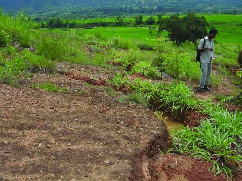
An area of heavily degraded grazing land was rehabilitated by establishing eyebrow pits to control and harvest runoff, planting trees and grasses, and fencing the site to control grazing. The main purpose was to re-establish vegetative cover on the almost bare, overgrazed site. The site is community land of the 40 households (240 people) of Dhotra village in the Jhikhu Khola watershed. These people are very dependent on this area due to the lack of alternative grazing sites. The rehabilitation site is surrounded by irrigated cropland downstream, grazing land, and degraded sal (Shorea robusta) dominated forest. Rainfed forward-sloping terraces immediately adjoin the site.
About 130 eyebrow pits were dug, together with catch drainage trenches. Several species of grass and fodder were planted along the ridges of the eyebrows and drainage trenches. Contour hedgerows were established between the eyebrow pits and trenches, and trees were planted just below the pits. The maintenance is quite easy: the vegetation needs to be cut back from time to time and the pits cleaned before the pre-monsoon period. The remaining bare areas should be revisited each year and replanted.
The area has a distinct dry season from November to May and a wet monsoon period from June to October. Annual rainfall is around 1200 mm. The site has red soils that are highly weathered and, if not properly managed, are very susceptible to erosion.
2.3 Photos de la Technologie
Galerie Médias
2.5 Pays/ région/ lieux où la Technologie a été appliquée et qui sont couverts par cette évaluation
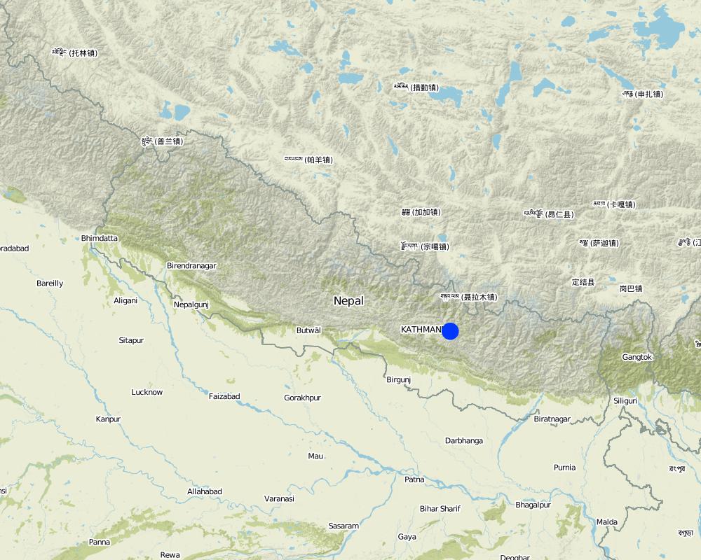
Pays:
Népal
Région/ Etat/ Province:
Kavre Palanchok/ Dhotra village, Jhikhu Khola watershed
Map
×2.6 Date de mise en œuvre de la Technologie
Si l'année précise est inconnue, indiquez la date approximative: :
- il y a moins de 10 ans (récemment)
2.7 Introduction de la Technologie
Spécifiez comment la Technologie a été introduite: :
- par le biais de projets/ d'interventions extérieures
Commentaires (type de projet, etc.) :
The hedgerow technology came from the Philliphines, modified from the SALT (Sloping agriculture land technology) technology. The eye brow pit technology was implemented by the Department of Soil Conservation and Watershed Management in Nepal and was adapted from them. Villagers approached the People and Resource Dynamics Project (PARDYP) for advice. PARDYP assisted, based on experiences made before with rehabilitation experiments under similar conditions. Mainly developed according to theoretical and site specific knowledge.
3. Classification de la Technologie de GDT
3.1 Principal(aux) objectif(s) de la Technologie
- réduire, prévenir, restaurer les terres dégradées
3.2 Type(s) actuel(s) d'utilisation des terres, là où la Technologie est appliquée

Pâturages
Pâturage extensif:
- Ranching
Commentaires:
Major land use problems (compiler’s opinion): The major land use problem is the small per capita landholding size for cropping. These holdings are mostly rainfed, have a low soil fertility status and acidity problems, and are susceptible to erosion. Intense rainfall at the beginning of the rainy season causes considerable soil loss (rill and gully erosion).
Major land use problems (land users’ perception): Overgrazing leading to lack of vegetation.
Ranching: Yes
Future (final) land use (after implementation of SLM Technology): Forests / woodlands: Fp: Plantations, afforestations
Si l'utilisation des terres a changé en raison de la mise en œuvre de la Technologie, indiquez l'utilisation des terres avant la mise en œuvre de la Technologie:
Grazing land: Ge: Extensive grazing land
3.3 Informations complémentaires sur l'utilisation des terres
Approvisionnement en eau des terres sur lesquelles est appliquée la Technologie:
- pluvial
Nombre de période de croissance par an: :
- 3
Précisez:
Longest growing period in days: 150; Longest growing period from month to month: Jun - Oct; Second longest growing period in days: 120; Second longest growing period from month to month: Nov - Feb
3.4 Groupe de GDT auquel appartient la Technologie
- Amélioration de la couverture végétale/ du sol
- dérivation et drainage de l'eau
3.5 Diffusion de la Technologie
Spécifiez la diffusion de la Technologie:
- répartie uniformément sur une zone
Si la Technologie est uniformément répartie sur une zone, indiquez la superficie couverte approximative:
- < 0,1 km2 (10 ha)
Commentaires:
Total area covered by the SLM Technology is 0.019 km2.
3.6 Mesures de GDT constituant la Technologie

pratiques végétales
- V1: Couverture d’arbres et d’arbustes

structures physiques
- S4: Fossés isohypses, trous

modes de gestion
- M5: Contrôle/ changement de la composition des espèces
Commentaires:
Main measures: vegetative measures, structural measures
Secondary measures: management measures
Type of vegetative measures: aligned: -contour, in blocks
3.7 Principaux types de dégradation des terres traités par la Technologie

érosion hydrique des sols
- Wt: perte de la couche superficielle des sols (couche arable)/ érosion de surface

dégradation physique des sols
- Pc: compaction
Commentaires:
Main type of degradation addressed: Wt: loss of topsoil / surface erosion
Secondary types of degradation addressed: Pc: compaction
Main causes of degradation: overgrazing (insufficient forage supply from the private land.), education, access to knowledge and support services (identification of appropriate SWC technologies and appropriate collaborators)
Secondary causes of degradation: deforestation / removal of natural vegetation (incl. forest fires) (for daily household needs ( litter , firewood, timber), other natural causes (avalanches, volcanic eruptions, mud flows, highly susceptible natural resources, extreme topography, etc.) specify (excessive rainfall during pre-monsoon and monsoon), poverty / wealth (to buy planting materials and for logistics), labour availability (for community level social work)
3.8 Prévention, réduction de la dégradation ou réhabilitation des terres dégradées
Spécifiez l'objectif de la Technologie au regard de la dégradation des terres:
- restaurer/ réhabiliter des terres sévèrement dégradées
4. Spécifications techniques, activités, intrants et coûts de mise en œuvre
4.1 Dessin technique de la Technologie
Auteur:
A.K. Thaku, Madhav Dhakal
4.2 Spécification/ explications techniques du dessin technique
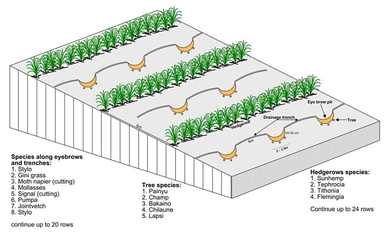
Technical drawing of layout of vegetative and structural measures.
Location: "Dhotra" village, near Dhulikhel. Kabhre Palanchok district
Date: July 2004
Technical knowledge required for field staff / advisors: low
Technical knowledge required for land users: low
Main technical functions: improvement of ground cover, increase / maintain water stored in soil, water harvesting / increase water supply
Secondary technical functions: reduction of slope angle, reduction of slope length, increase in organic matter
Aligned: -contour
Vegetative material: G : grass
Spacing between rows / strips / blocks (m): 6 m
In blocks
Vegetative material: T : trees / shrubs
Number of plants per (ha): 120
Spacing between rows / strips / blocks (m): 6 m
Vertical interval within rows / strips / blocks (m): 4 m
Trees/ shrubs species: Prunus cerasoides, Michelia champaca, Melia azedarach, Schima wallichii,Cherospondias axillaries
Grass species: Stylosanthes guianensis, Panicum maximum, Pennisetum purpureum, Melinis minutiflora, Brachiaria decu
Slope (which determines the spacing indicated above): 20.00%
Gradient along the rows / strips: 2.00%
Wall/ barrier
Spacing between structures (m): 5-10 m
Height of bunds/banks/others (m): 1-2 m
Width of bunds/banks/others (m): 1 m
Length of bunds/banks/others (m): 1.5-4 m
Bund/ bank: semi-circular/V shaped trapezoidal
Spacing between structures (m): 6 m
Depth of ditches/pits/dams (m): 40-50 cm
Width of ditches/pits/dams (m): 1-1.5m
Length of ditches/pits/dams (m): 2-2.5 m
Height of bunds/banks/others (m): 10-30
Width of bunds/banks/others (m): 1-1.5 m
Length of bunds/banks/others (m): 1-2 m
Structural measure: diversion ditch / cut-off drain
Spacing between structures (m): 6 m
Depth of ditches/pits/dams (m): 0-30 cm
Width of ditches/pits/dams (m): 10-30 cm
Construction material (earth): soil resulting from the digging activities were used to construct eyebrow shaped bunds.
Slope (which determines the spacing indicated above): 20%
Lateral gradient along the structure: 2%
Vegetation is used for stabilisation of structures.
Other type of management: closing for change of management / intensity level - grazing as well as "symbolic" fencing by small living fence to delineate SWC area.
4.3 Informations générales sur le calcul des intrants et des coûts
Indiquez la monnaie utilisée pour le calcul des coûts:
- dollars US
Indiquez le coût salarial moyen de la main d'œuvre par jour:
2.00
4.4 Activités de mise en place/ d'établissement
| Activité | Type de mesures | Calendrier | |
|---|---|---|---|
| 1. | Planting of tree seedlings and cuttings and sowing of grass seeds. | Végétale | before onset of monsoon (June) |
| 2. | Drawing layout of eyebrow terraces, drainage ditches, hedgerows on the bare land | Structurel | before onset of monsoon (June) |
| 3. | Digging holes for eyebrow pits, drainage ditches | Structurel | before onset of monsoon (June) |
| 4. | Making sure that all livestock is stall- fed | Modes de gestion | All the time |
| 5. | Establishing small live fences with grasses and shrub cuttings | Modes de gestion | before onset of monsoon (June) |
4.5 Coûts et intrants nécessaires à la mise en place
| Spécifiez les intrants | Unité | Quantité | Coûts par unité | Coût total par intrant | % du coût supporté par les exploitants des terres | |
|---|---|---|---|---|---|---|
| Main d'œuvre | Eyebrow terraces and vegetative measure | Persons/day | 52,0 | 2,0 | 104,0 | 100,0 |
| Matériel végétal | Seeds | ha | 1,0 | 6,0 | 6,0 | |
| Matériel végétal | Seedlings | ha | 1,0 | 23,0 | 23,0 | |
| Engrais et biocides | Fertilizer | ha | 1,0 | 12,0 | 12,0 | |
| Autre | Transportation | ha | 1,0 | 41,0 | 41,0 | |
| Autre | Lunch, tea for farmers | ha | 1,0 | 47,0 | 47,0 | |
| Coût total de mise en place de la Technologie | 233,0 | |||||
Commentaires:
Duration of establishment phase: 12 month(s)
4.6 Activités d'entretien/ récurrentes
| Activité | Type de mesures | Calendrier/ fréquence | |
|---|---|---|---|
| 1. | cutting vegetation | Végétale | 3 times /year |
| 2. | planting vegetation in any gaps | Végétale | before monsun /annual |
| 3. | Cleaning of sediment-filled pits | Structurel | oncea year, before onset of monsoon |
4.7 Coûts et intrants nécessaires aux activités d'entretien/ récurrentes (par an)
Commentaires:
Machinery/ tools: hoe, spade,sickle, hoe, spade
All costs and amounts were roughly estimated by the technicians and authors in 2004.
5. Environnement naturel et humain
5.1 Climat
Précipitations annuelles
- < 250 mm
- 251-500 mm
- 501-750 mm
- 751-1000 mm
- 1001-1500 mm
- 1501-2000 mm
- 2001-3000 mm
- 3001-4000 mm
- > 4000 mm
Zone agro-climatique
- humide
Thermal climate class: subtropics
5.2 Topographie
Pentes moyennes:
- plat (0-2 %)
- faible (3-5%)
- modéré (6-10%)
- onduleux (11-15%)
- vallonné (16-30%)
- raide (31-60%)
- très raide (>60%)
Reliefs:
- plateaux/ plaines
- crêtes
- flancs/ pentes de montagne
- flancs/ pentes de colline
- piémonts/ glacis (bas de pente)
- fonds de vallée/bas-fonds
Zones altitudinales:
- 0-100 m
- 101-500 m
- 501-1000 m
- 1001-1500 m
- 1501-2000 m
- 2001-2500 m
- 2501-3000 m
- 3001-4000 m
- > 4000 m
Commentaires et précisions supplémentaires sur la topographie:
Altitudinal zone: 900 m a.s.l.
Slopes on average: Also very steep
5.3 Sols
Profondeur moyenne du sol:
- très superficiel (0-20 cm)
- superficiel (21-50 cm)
- modérément profond (51-80 cm)
- profond (81-120 cm)
- très profond (>120 cm)
Texture du sol (de la couche arable):
- fin/ lourd (argile)
Matière organique de la couche arable:
- faible (<1%)
Si disponible, joignez une description complète du sol ou précisez les informations disponibles, par ex., type de sol, pH/ acidité du sol, capacité d'échange cationique, azote, salinité, etc.
Soil depth on average is variable
Soil texture: red soils with high clay content
Soil fertility was very low before implementation of rehabilitation activities
Topsoil organic matter was low before implementation of rehabilitation activities
Soil drainage / infiltration was poor before implementation of rehabilitation activities
Soil water storage capacity was very low before implementation of rehabilitation activities
5.4 Disponibilité et qualité de l'eau
Disponibilité de l’eau de surface:
faible/ absente
Qualité de l’eau (non traitée):
faiblement potable (traitement nécessaire)
Commentaires et précisions supplémentaires sur la qualité et la quantité d'eau:
Water quality (untreated): More in rainy season (June- September), less in April/May
5.6 Caractéristiques des exploitants des terres appliquant la Technologie
Orientation du système de production:
- subsistance (auto-approvisionnement)
Revenus hors exploitation:
- 10-50% de tous les revenus
Niveau relatif de richesse:
- pauvre
Individus ou groupes:
- groupe/ communauté
Genre:
- femmes
- hommes
Indiquez toute autre caractéristique pertinente des exploitants des terres:
Land users applying the Technology are mainly common / average land users
Population density: 200-500 persons/km2
Annual population growth: 2% - 3%
95% of the land users are average wealthy.
3% of the land users are poor.
2% of the land users are poor.
Off-farm income specification: In most farm households, off-farm income plays at least a minor and
increasingly a major role. Occasional opportunities for off-farm income present themselves in the form of daily
labour wages. Some households’ members receive regular salaries, whilst an increasing number of Nepalis are
working in India, the Middle East, Malaysia, and elsewhere and sending remittance incomes home.
5.7 Superficie moyenne des terres détenues ou louées par les exploitants appliquant la Technologie
- < 0,5 ha
- 0,5-1 ha
- 1-2 ha
- 2-5 ha
- 5-15 ha
- 15-50 ha
- 50-100 ha
- 100-500 ha
- 500-1 000 ha
- 1 000-10 000 ha
- > 10 000 ha
Cette superficie est-elle considérée comme de petite, moyenne ou grande dimension (en se référant au contexte local)?
- petite dimension
Commentaires:
Only limited grazing area for whole village
5.8 Propriété foncière, droits d’utilisation des terres et de l'eau
Propriété foncière:
- état
Droits d’utilisation des terres:
- communautaire (organisé)
5.9 Accès aux services et aux infrastructures
santé:
- pauvre
- modéré
- bonne
éducation:
- pauvre
- modéré
- bonne
assistance technique:
- pauvre
- modéré
- bonne
emploi (par ex. hors exploitation):
- pauvre
- modéré
- bonne
marchés:
- pauvre
- modéré
- bonne
énergie:
- pauvre
- modéré
- bonne
routes et transports:
- pauvre
- modéré
- bonne
eau potable et assainissement:
- pauvre
- modéré
- bonne
services financiers:
- pauvre
- modéré
- bonne
6. Impacts et conclusions
6.1 Impacts sur site que la Technologie a montrés
Impacts socio-économiques
Revenus et coûts
revenus agricoles
Commentaires/ spécifiez:
Increased carrying capacity of land; about $17 was collected from selling grass seeds and grass
Impacts socioculturels
institutions communautaires
Commentaires/ spécifiez:
collected money used for social work
connaissances sur la GDT/ dégradation des terres
apaisement des conflits
Commentaires/ spécifiez:
At the beginning a few people opposed the activities
Impacts écologiques
Cycle de l'eau/ ruissellement
drainage de l'excès d'eau
Sols
humidité du sol
couverture du sol
Commentaires/ spécifiez:
about 80 percent bare land covered by the various grasses
perte en sol
6.2 Impacts hors site que la Technologie a montrés
envasement en aval
Commentaires/ spécifiez:
into irrigation canal downstream
6.3 Exposition et sensibilité de la Technologie aux changements progressifs et aux évènements extrêmes/catastrophes liés au climat (telles que perçues par les exploitants des terres)
Changements climatiques progressifs
Changements climatiques progressifs
| Saison | Type de changements/ extrêmes climatiques | Comment la Technologie fait-elle face à cela? | |
|---|---|---|---|
| températures annuelles | augmente | bien |
Extrêmes climatiques (catastrophes)
Catastrophes météorologiques
| Comment la Technologie fait-elle face à cela? | |
|---|---|
| pluie torrentielle locale | pas bien |
| tempête de vent locale | pas connu |
Catastrophes climatiques
| Comment la Technologie fait-elle face à cela? | |
|---|---|
| sécheresse | pas bien |
Catastrophes hydrologiques
| Comment la Technologie fait-elle face à cela? | |
|---|---|
| inondation générale (rivière) | pas connu |
Autres conséquences liées au climat
Autres conséquences liées au climat
| Comment la Technologie fait-elle face à cela? | |
|---|---|
| réduction de la période de croissance | pas bien |
6.4 Analyse coûts-bénéfices
Quels sont les bénéfices comparativement aux coûts de mise en place (du point de vue des exploitants des terres)?
Rentabilité à court terme:
neutre / équilibrée
Rentabilité à long terme:
positive
Quels sont les bénéfices comparativement aux coûts d'entretien récurrents (du point de vue des exploitants des terres)?
Rentabilité à court terme:
neutre / équilibrée
Rentabilité à long terme:
positive
Commentaires:
The high establishment costs of the technology means that the shortterm benefit for the community only matches the costs involved. In the long-term the environmental benefit of rehabilitated land is high and
economically it is positive.
6.5 Adoption de la Technologie
- plus de 50%
Si disponible, quantifiez (nombre de ménages et/ou superficie couverte):
40 households in an area of 0.019 sq km
Parmi tous ceux qui ont adopté la Technologie, combien d'entre eux l'ont fait spontanément, à savoir sans recevoir aucune incitation matérielle ou aucun paiement?
- 0-10%
Commentaires:
100% of land user families have adopted the Technology with external material support
40 land user families have adopted the Technology with external material support
Comments on acceptance with external material support: survey results
There is no trend towards spontaneous adoption of the Technology
Comments on adoption trend: No initiative could be seen in the area , but inerst is there.
6.7 Points forts/ avantages/ possibilités de la Technologie
| Points forts/ avantages/ possibilités du point de vue de l'exploitant des terres |
|---|
|
The technology already started generating income from the degraded land. How can they be sustained / enhanced? In the long run, by selling grass and grass seed, funds can be generated. |
|
The technology is effective against land degradation. How can they be sustained / enhanced? More tree and fruit species should be added and grass species multiplied to cover the remaining bare land |
| Points forts/ avantages/ possibilités du point de vue du compilateur ou d'une autre personne ressource clé |
|---|
|
The technology package is easy to apply as it does not need much knowledge and is cost effective. How can they be sustained / enhanced? Regular maintenance of the structure and grasses is required |
|
Improvement can be seen fast and easily; the vegetation cover increased and the loss of top soil decreased. How can they be sustained / enhanced? As above |
7. Références et liens
7.2 Références des publications disponibles
Titre, auteur, année, ISBN:
Nakarmi, G. (2000) Soil Erosion Dynamics in the Middle Mountains of Nepal, a report submitted to PARDYP, ICIMOD, Kathmandu.
Disponible à partir d'où? Coût?
ICIMOD
Titre, auteur, année, ISBN:
Schreier, H.; Brown, S.; Shah, P. B.; Shrestha, B.; Merz, J. (2002) Jhikhu Khola Watershed – Nepal, CD ROM. Vancouver: Institute for Resources and Environment, University of British Columbia.
Disponible à partir d'où? Coût?
ICIMOD
Titre, auteur, année, ISBN:
Shrestha, B. (2004) Progress Report PARDYP-Nepal. Paper presented at the PARDYP – Access Mid Year Meeting, 19-22 July 2004, ICIMOD, Kathmandu.
Liens et modules
Développer tout Réduire toutLiens
Aucun lien
Modules
Aucun module trouvé