Rehabilitation of Degraded Lands ( Area closure) [Ethiopie]
- Création :
- Mise à jour :
- Compilateur : Unknown User
- Rédacteur : –
- Examinateurs : Fabian Ottiger, Alexandra Gavilano
Kutura
technologies_1072 - Ethiopie
Voir les sections
Développer tout Réduire tout1. Informations générales
1.2 Coordonnées des personnes-ressources et des institutions impliquées dans l'évaluation et la documentation de la Technologie
1.3 Conditions relatives à l'utilisation par WOCAT des données documentées
Le compilateur et la(les) personne(s) ressource(s) acceptent les conditions relatives à l'utilisation par WOCAT des données documentées:
Oui
1.5 Référence au(x) Questionnaires sur les Approches de GDT (documentées au moyen de WOCAT)
Community Organizations and Mobilization for Soil and Water … [Ethiopie]
Community mobilization for soil and water conservation work in a watershed planning unit is an approach for collective action by organizing all active labor forces living in the kebele/peasant association into development group of 20-30 members and further divide into 1:5 work force to implement construction of soil and water …
- Compilateur : Gizaw Desta Gessesse
2. Description de la Technologie de GDT
2.1 Courte description de la Technologie
Définition de la Technologie:
Closing the degraded land to let it to regenerate by excluding human and animal interference ans speed up the regeneration process by applying some SWC activities and undertake enrichment plantation.
2.2 Description détaillée de la Technologie
Description:
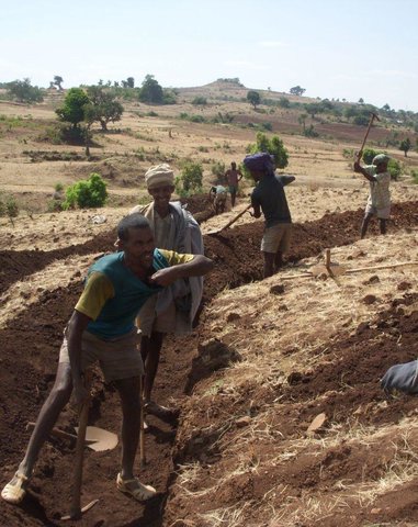
Area closure is suitable for degraded lands. Degraded areas are excluded from animal and human contact and integrated with activities that speed up regeneration process such as SWC activities, agronomic measures, vegetative and management measures.
Purpose of the Technology: Area closure improves the productivity of degraded lands and protects down stream fields and properties from flooding and improves ground water recharge.
Establishment / maintenance activities and inputs: Management and utilization plan prepared and agreed. Planning and design of supplimentary measures are integrated.
Natural / human environment: Area closure is applicable in all areas that have lost vegetation cover and has low soil fertility.
2.5 Pays/ région/ lieux où la Technologie a été appliquée et qui sont couverts par cette évaluation
Pays:
Ethiopie
Région/ Etat/ Province:
SNNPR
Autres spécifications du lieu:
Lemo
Commentaires:
Total area covered by the SLM Technology is 10.5 km2.
Communities develop positive attitude towards activities implemented and results obtained such as livestock feed, fuel wood, bee forage, farm implements and construction materials.
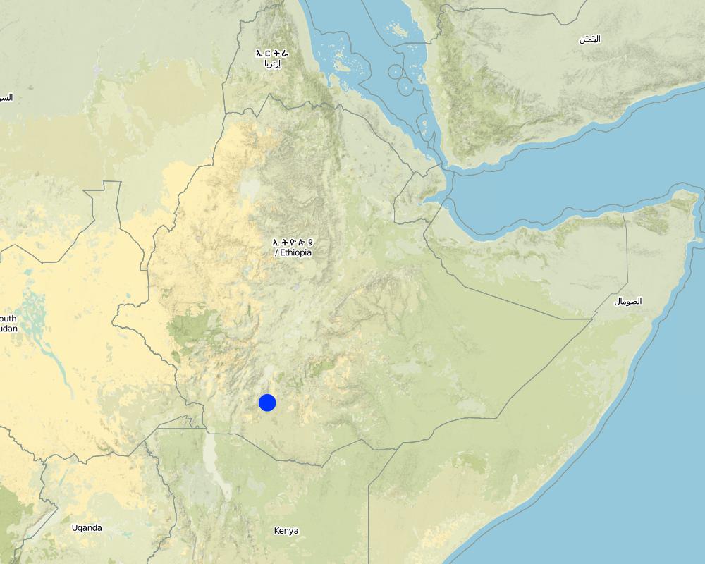
Map
×2.6 Date de mise en œuvre de la Technologie
Si l'année précise est inconnue, indiquez la date approximative: :
- il y a plus de 50 ans (technologie traditionnelle)
2.7 Introduction de la Technologie
Spécifiez comment la Technologie a été introduite: :
- par le biais de projets/ d'interventions extérieures
Commentaires (type de projet, etc.) :
It is introduced technology.
3. Classification de la Technologie de GDT
3.1 Principal(aux) objectif(s) de la Technologie
- réduire, prévenir, restaurer les terres dégradées
- préserver l'écosystème
3.2 Type(s) actuel(s) d'utilisation des terres, là où la Technologie est appliquée
Les divers types d'utilisation des terres au sein du même unité de terrain: :
Oui
Précisez l'utilisation mixte des terres (cultures/ pâturages/ arbres):
- Agro-sylvo-pastoralisme

Terres cultivées
- Cultures annuelles
- Cultures pérennes (non ligneuses)
- Plantations d’arbres ou de buissons
Cultures annuelles - Précisez les cultures:
- céréales - orge
- céréales - maïs
- céréales - autres
- légumineuses et légumes secs - fèves
- plantes à racines et à tubercules - pommes de terre
- wheat, teff, legumes, haricot
- Enset, Desho, phalaris
Plantations d'arbres et d'arbustes - Précisez les cultures:
- café, cultivé en plein champ
- chat, Acacia saligina, Acaccia decurrens, Omedila, Grevillea robusta
Nombre de période de croissance par an: :
- 2
Précisez:
Longest growing period in days: 180 Longest growing period from month to month: Apr - Nov Second longest growing period in days: 150 Second longest growing period from month to month: Jan - May
Est-ce que les cultures intercalaires sont pratiquées?
Oui
Si oui, précisez quelles cultures sont produites en culture intercalaire:
maize & haricot bean

Forêts/ bois
- Plantations d'arbres, boisements
Produits et services:
- Bois d'œuvre (de construction)
- Bois de chauffage
- Pâturage/ broutage
- Conservation/ protection de la nature
Commentaires:
Major land use problems (compiler’s opinion): Overgrazing, low awarness of land users, lack of management plan for communal lands and low level of diversification of land users activities.
Major land use problems (land users’ perception): Shortage of grazing lands, lack of common understanding of the management of common resources.
Semi-nomadism / pastoralism: Yes
Grazingland comments: Inspite of decreasing grazing lands, farmers still want to own some heads of livestock. Grazinglands as a result are highly pressurized. Land users cut grass from area closures and carry them home to feed their livestock. Some land users who have few polts for grazing close them to grow grass.
Plantation forestry: Yes
Problems / comments regarding forest use: Natural forests do not exist. Planted forests are managed by the community. In the SWC area, a larger area was planted some 20 years ago but at present the planted forests have been cleared for cultivation. This is the result of high population growth. Some of the planteed forests have been cleared by demobilizing soldiers.
Type of cropping system and major crops comments: Cereals - Legumes - Cereals
Constraints of infrastructure network (roads, railways, pipe lines, power lines)
3.4 Approvisionnement en eau
Approvisionnement en eau des terres sur lesquelles est appliquée la Technologie:
- pluvial
3.5 Groupe de GDT auquel appartient la Technologie
- fermeture de zones (arrêt de tout usage, appui à la réhabilitation)
3.6 Mesures de GDT constituant la Technologie
3.7 Principaux types de dégradation des terres traités par la Technologie

érosion hydrique des sols
- Wt: perte de la couche superficielle des sols (couche arable)/ érosion de surface
- Wg: ravinement/ érosion en ravines
- Wo: effets hors-site de la dégradation

dégradation chimique des sols
- Cn: baisse de la fertilité des sols et réduction du niveau de matière organique (non causée par l’érosion)

dégradation physique des sols
- Pu: perte de la fonction de bio-production en raison d’autres activités

dégradation hydrique
- Ha: aridification
Commentaires:
Main type of degradation addressed: Wt: loss of topsoil / surface erosion, Wg: gully erosion / gullying
Secondary types of degradation addressed: Wo: offsite degradation effects, Cn: fertility decline and reduced organic matter content, Pu: loss of bio-productive function due to other activities, Ha: aridification
3.8 Prévention, réduction de la dégradation ou réhabilitation des terres dégradées
Spécifiez l'objectif de la Technologie au regard de la dégradation des terres:
- restaurer/ réhabiliter des terres sévèrement dégradées
Commentaires:
Secondary goals: prevention of land degradation, mitigation / reduction of land degradation
4. Spécifications techniques, activités, intrants et coûts de mise en œuvre
4.1 Dessin technique de la Technologie
Spécifications techniques (associées au dessin technique):
SNNPR
Technical knowledge required for field staff / advisors: high
Technical knowledge required for land users: low
Main technical functions: control of dispersed runoff: retain / trap, control of concentrated runoff: retain / trap, improvement of ground cover, increase of infiltration
Secondary technical functions: increase / maintain water stored in soil, water harvesting / increase water supply, increase in soil fertility
Early planting
Material/ species: maize and potato
Remarks: row planting, broad casting
Mixed cropping / intercropping
Material/ species: maize & haricot bean
Remarks: row planting
Legume inter-planting
Remarks: broad casting
Manure / compost / residues
Material/ species: animal dung
Remarks: broad casting
Contour tillage
Remarks: along the contour
In blocks
Vegetative material: T : trees / shrubs
Number of plants per (ha): 2500
Vertical interval within rows / strips / blocks (m): 2
Vegetative measure: in blocks
Vegetative material: G : grass
Number of plants per (ha): 3333
Vertical interval between rows / strips / blocks (m): 1
Spacing between rows / strips / blocks (m): 10
Vertical interval within rows / strips / blocks (m): 0.3
Width within rows / strips / blocks (m): 0.3
Vegetative measure: Vegetative material: G : grass
Vegetative measure: Vegetative material: G : grass
Vegetative measure: Vegetative material: G : grass
Trees/ shrubs species: Acacia saligina, Acaccia decurrens, Omedila, Grevillea robusta
Grass species: Desho, phalaris
Slope (which determines the spacing indicated above): 15.00%
If the original slope has changed as a result of the Technology, the slope today is (see figure below): 8.00%
Gradient along the rows / strips: 0.00%
Retention/infiltration ditch/pit, sediment/sand trap
Vertical interval between structures (m): 3
Spacing between structures (m): 10
Depth of ditches/pits/dams (m): 0.5
Width of ditches/pits/dams (m): 0.3
Length of ditches/pits/dams (m): 3
Height of bunds/banks/others (m): 0.3
Width of bunds/banks/others (m): 1
Length of bunds/banks/others (m): 3
Terrace: forward sloping
Vertical interval between structures (m): 2
Spacing between structures (m): 10
Depth of ditches/pits/dams (m): 0.3
Width of ditches/pits/dams (m): 0.5
Length of ditches/pits/dams (m): 5
Height of bunds/banks/others (m): 0.3
Width of bunds/banks/others (m): 1
Length of bunds/banks/others (m): 30
Construction material (earth): Soil excavated from the ditches is used to make the embankment
Construction material (stone): Hill side terraces are supported with stones at the downslope side to make them stronger and stable.
Slope (which determines the spacing indicated above): 15%
If the original slope has changed as a result of the Technology, the slope today is: 8%
Lateral gradient along the structure: 0%
Vegetation is used for stabilisation of structures.
Change of land use type: from degraded agricultural land to area closure and practicing of cut and carry.
Other type of management: change of management / intensity level - from open access forms of grazing to guarding, plantation and construction of various SWC techniques.
4.2 Informations générales sur le calcul des intrants et des coûts
autre/ monnaie nationale (précisez):
Birr
Indiquez le taux de change des USD en devise locale, le cas échéant (p.ex. 1 USD = 79.9 réal brésilien): 1 USD = :
8,6
Indiquez le coût salarial moyen de la main d'œuvre par jour:
0.70
4.3 Activités de mise en place/ d'établissement
| Activité | Calendrier des activités (saisonnier) | |
|---|---|---|
| 1. | Seedling production | through out the year |
| 2. | Transportation | beginning of rains |
| 3. | Planting | beginning of rains |
| 4. | Surveying | dry season |
| 5. | Digging of ditches and construction of structural measures | dry season |
| 6. | Stablization of terraces | |
| 7. | Surveying the degraded land | dry season |
| 8. | Awarness creation | slack period from farming |
| 9. | Planning | any time |
| 10. | Closing the area |
4.4 Coûts et intrants nécessaires à la mise en place
| Spécifiez les intrants | Unité | Quantité | Coûts par unité | Coût total par intrant | % du coût supporté par les exploitants des terres | |
|---|---|---|---|---|---|---|
| Main d'œuvre | Labour | ha | 1,0 | 505,8 | 505,8 | 50,0 |
| Equipements | Machine use | ha | 1,0 | 83,27 | 83,27 | |
| Equipements | Tools | ha | 1,0 | 19,26 | 19,26 | 70,0 |
| Matériel végétal | Seeds | ha | 1,0 | 69,76 | 69,76 | 100,0 |
| Matériel végétal | Seedlings | ha | 1,0 | 116,28 | 116,28 | 100,0 |
| Coût total de mise en place de la Technologie | 794,37 | |||||
| Coût total de mise en place de la Technologie en dollars américains (USD) | 92,37 | |||||
Commentaires:
Duration of establishment phase: 24 month(s)
4.5 Activités d'entretien/ récurrentes
| Activité | Calendrier/ fréquence | |
|---|---|---|
| 1. | land preparation | before rains / each cropping season |
| 2. | Replanting | rainy season /once |
| 3. | Stablization of terraces | rainy season/annual |
| 4. | Appointing guards | / annual |
4.6 Coûts et intrants nécessaires aux activités d'entretien/ récurrentes (par an)
| Spécifiez les intrants | Unité | Quantité | Coûts par unité | Coût total par intrant | % du coût supporté par les exploitants des terres | |
|---|---|---|---|---|---|---|
| Equipements | Machine use | ha | 1,0 | 81,39 | 81,39 | |
| Matériel végétal | Seedlings | ha | 1,0 | 7,3 | 7,3 | 100,0 |
| Coût total d'entretien de la Technologie | 88,69 | |||||
| Coût total d'entretien de la Technologie en dollars américains (USD) | 10,31 | |||||
Commentaires:
Machinery/ tools: hoe, shovel, gaso
The cost is calculated for labour needed to the construct SWC activities to rehablitate one hectar of degraded land.
4.7 Facteurs les plus importants affectant les coûts
Décrivez les facteurs les plus importants affectant les coûts :
Higher slopes and shallow soil depths increase the cost of construction.
5. Environnement naturel et humain
5.1 Climat
Précipitations annuelles
- < 250 mm
- 251-500 mm
- 501-750 mm
- 751-1000 mm
- 1001-1500 mm
- 1501-2000 mm
- 2001-3000 mm
- 3001-4000 mm
- > 4000 mm
Spécifications/ commentaires sur les précipitations:
900-1400 mm
Zone agro-climatique
- subhumide
> 180 days of LGP
5.2 Topographie
Pentes moyennes:
- plat (0-2 %)
- faible (3-5%)
- modéré (6-10%)
- onduleux (11-15%)
- vallonné (16-30%)
- raide (31-60%)
- très raide (>60%)
Reliefs:
- plateaux/ plaines
- crêtes
- flancs/ pentes de montagne
- flancs/ pentes de colline
- piémonts/ glacis (bas de pente)
- fonds de vallée/bas-fonds
Zones altitudinales:
- 0-100 m
- 101-500 m
- 501-1000 m
- 1001-1500 m
- 1501-2000 m
- 2001-2500 m
- 2501-3000 m
- 3001-4000 m
- > 4000 m
Commentaires et précisions supplémentaires sur la topographie:
Altitudinal zone: 2001-2500 m a.s.l. ( <2400m a.s.l., ranked 1) and 1,501-2,000 m a.s.l. ( >1900m a.s.l., ranked 2)
Slopes on average: Rolling (ranked 1), hilly (ranked 2) and gentle, moderate and steep (all ranked 3)
5.3 Sols
Profondeur moyenne du sol:
- très superficiel (0-20 cm)
- superficiel (21-50 cm)
- modérément profond (51-80 cm)
- profond (81-120 cm)
- très profond (>120 cm)
Texture du sol (de la couche arable):
- moyen (limoneux)
- fin/ lourd (argile)
Matière organique de la couche arable:
- moyen (1-3%)
- faible (<1%)
Si disponible, joignez une description complète du sol ou précisez les informations disponibles, par ex., type de sol, pH/ acidité du sol, capacité d'échange cationique, azote, salinité, etc.
Soil depth on average: Also moderately deep (ranked 2) and shallow (ranked 3)
Soil texture: Fine/heavy (mainly clay loam, ranked 1) and medium (ranked 2)
Soil fertility is medium (ranked 1), low (ranked 2), high (ranked 3)
Soil drainage/infiltration is good (ranked 1) and medium (ranked 2)
Soil water storage capacity high (ranked 1) and medium (ranked 2)
5.6 Caractéristiques des exploitants des terres appliquant la Technologie
Orientation du système de production:
- subsistance (auto-approvisionnement)
- exploitation mixte (de subsistance/ commerciale)
Revenus hors exploitation:
- moins de 10% de tous les revenus
Niveau relatif de richesse:
- pauvre
- moyen
Niveau de mécanisation:
- travail manuel
- traction animale
Indiquez toute autre caractéristique pertinente des exploitants des terres:
Population density: 200-500 persons/km2
Annual population growth: 3% - 4%
6% of the land users are rich and own 15% of the land.
45% of the land users are average wealthy and own 40% of the land.
35% of the land users are poor and own 30% of the land.
12% of the land users are poor and own 20% of the land.
Off-farm income specification: Some land users are engaged in small trading and some are daily labourer when they are free from field activities.
Level of mechanization: Animal traction (oxen plough system, ranked 1) and manual work (hoe and gaso, ranked 2)
Market orientation of forest production system: Mixed (ranked 1, individual plantation for market and domestic consumption), subsistence (ranked 2, individual woodlots plantation for domestic consumption) and commercial/market (ranked 3, community plantation for sale)
5.7 Superficie moyenne des terres utilisées par les exploitants des terres appliquant la Technologie
- < 0,5 ha
- 0,5-1 ha
- 1-2 ha
- 2-5 ha
- 5-15 ha
- 15-50 ha
- 50-100 ha
- 100-500 ha
- 500-1 000 ha
- 1 000-10 000 ha
- > 10 000 ha
Commentaires:
Crop land: Average holding size is about 0.5 ha
Grazing land: Owing to expansion of cultivated land, grazing land size has reduced and estimated at about 0.1 ha per household.
Forest land: Due to cultivated land expansion the average holding size is about 0.15ha
5.8 Propriété foncière, droits d’utilisation des terres et de l'eau
Propriété foncière:
- état
Droits d’utilisation des terres:
- individuel
6. Impacts et conclusions
6.1 Impacts sur site que la Technologie a montrés
Impacts socio-économiques
Production
production agricole
Commentaires/ spécifiez:
soil depth increased and soil fertility improved.
production fourragère
Commentaires/ spécifiez:
biomass increased
qualité des fourrages
Commentaires/ spécifiez:
biomass increased
production de bois
Commentaires/ spécifiez:
construction and fuel wood available
Revenus et coûts
revenus agricoles
Commentaires/ spécifiez:
land productivity per unit area improved.
Impacts socioculturels
institutions communautaires
institutions nationales
connaissances sur la GDT/ dégradation des terres
apaisement des conflits
Commentaires/ spécifiez:
loss of land for grazing and cultivation
Impacts écologiques
Cycle de l'eau/ ruissellement
drainage de l'excès d'eau
Sols
humidité du sol
Commentaires/ spécifiez:
productivity is enhanced
couverture du sol
Commentaires/ spécifiez:
vegetation cover is improved
Biodiversité: végétale, animale
contrôle des animaux nuisibles/ maladies
Commentaires/ spécifiez:
Introduction of pests/wild animals
Autres impacts écologiques
Soil fertility
Biodiversity
6.2 Impacts hors site que la Technologie a montrés
flux des cours d'eau fiables et stables en saison sèche
Commentaires/ spécifiez:
ground water recharging is improved
inondations en aval
Commentaires/ spécifiez:
runoff from the watershed is highly reduced
envasement en aval
Commentaires/ spécifiez:
sediments deposited behind the bund
6.4 Analyse coûts-bénéfices
Quels sont les bénéfices comparativement aux coûts de mise en place (du point de vue des exploitants des terres)?
Rentabilité à court terme:
négative
Rentabilité à long terme:
positive
Quels sont les bénéfices comparativement aux coûts d'entretien récurrents (du point de vue des exploitants des terres)?
Rentabilité à court terme:
légèrement positive
Rentabilité à long terme:
positive
6.5 Adoption de la Technologie
Si disponible, quantifiez (nombre de ménages et/ou superficie couverte):
3990
De tous ceux qui ont adopté la Technologie, combien d'entre eux l'ont fait spontanément, à savoir sans recevoir aucune incitation matérielle, ou aucune rémunération? :
- 0-10%
Commentaires:
97% of land user families have adopted the Technology with external material support
3800 land user families have adopted the Technology with external material support
Comments on acceptance with external material support: estimates
5% of land user families have adopted the Technology without any external material support
190 land user families have adopted the Technology without any external material support
Comments on spontaneous adoption: estimates
There is a moderate trend towards spontaneous adoption of the Technology
Comments on adoption trend: The farmers have made some modifications in order to increase the effectivness of the technology, by making fences around enclosures.
6.7 Points forts/ avantages/ possibilités de la Technologie
| Points forts/ avantages/ possibilités du point de vue de l'exploitant des terres |
|---|
|
Feed and forage sources improved How can they be sustained / enhanced? Cut and carry system |
|
Availability of fuel wood, farm implements and construction materials How can they be sustained / enhanced? integrate with multipurpose tree species |
| Income from beekeeping due to area closure |
| Points forts/ avantages/ possibilités du point de vue du compilateur ou d'une autre personne ressource clé |
|---|
|
Income generated from wood and grass sales. How can they be sustained / enhanced? Equal share from the benefit to all land users. |
|
Rapid recovery and rehabilitation of degraded lands. How can they be sustained / enhanced? Integrate with multipurpose techniques and encourage cut and carry system. |
|
The environment is protected, wildlife attracted and unproductive areas become productive. How can they be sustained / enhanced? Awarness creation and technical support |
7. Références et liens
7.1 Méthodes/ sources d'information
Liens et modules
Développer tout Réduire toutLiens
Community Organizations and Mobilization for Soil and Water … [Ethiopie]
Community mobilization for soil and water conservation work in a watershed planning unit is an approach for collective action by organizing all active labor forces living in the kebele/peasant association into development group of 20-30 members and further divide into 1:5 work force to implement construction of soil and water …
- Compilateur : Gizaw Desta Gessesse
Modules
Aucun module trouvé