Auto-Flowing Slurry Dam [Chine]
- Création :
- Mise à jour :
- Compilateur : Yan ZHANG
- Rédacteur : –
- Examinateurs : David Streiff, Alexandra Gavilano
Falling Water Dam
technologies_1364 - Chine
Voir les sections
Développer tout Réduire tout1. Informations générales
1.2 Coordonnées des personnes-ressources et des institutions impliquées dans l'évaluation et la documentation de la Technologie
Nom du ou des institutions qui ont facilité la documentation/ l'évaluation de la Technologie (si pertinent)
Department of Resources and Environmental Science, Beijing Normal University (Department of Resources and Environmental Science, Beijing Normal University) - Chine1.3 Conditions relatives à l'utilisation par WOCAT des données documentées
Le compilateur et la(les) personne(s) ressource(s) acceptent les conditions relatives à l'utilisation par WOCAT des données documentées:
Oui
1.5 Référence au(x) Questionnaires sur les Approches de GDT (documentées au moyen de WOCAT)
Falling Water Dam [Chine]
The falling water dams are widely built in the middle reach of the Yellow River, the typical dams are filled with dense slurry by water flow from upland. The approach is implemented mainly by government investment.
- Compilateur : Yan ZHANG
2. Description de la Technologie de GDT
2.1 Courte description de la Technologie
Définition de la Technologie:
Auto-flowing slurry dams is filled with dense slurry by water flow from upland to maintain eroded soil particles and runoff.
2.2 Description détaillée de la Technologie
Description:
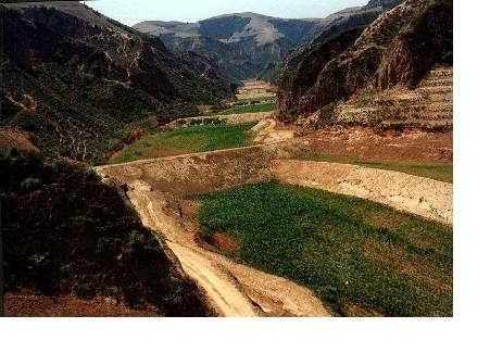
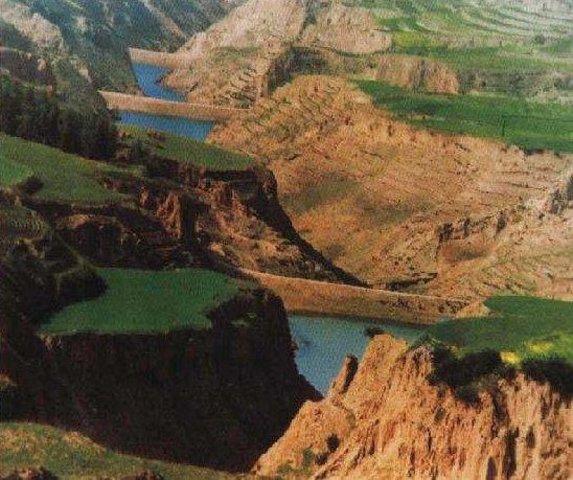
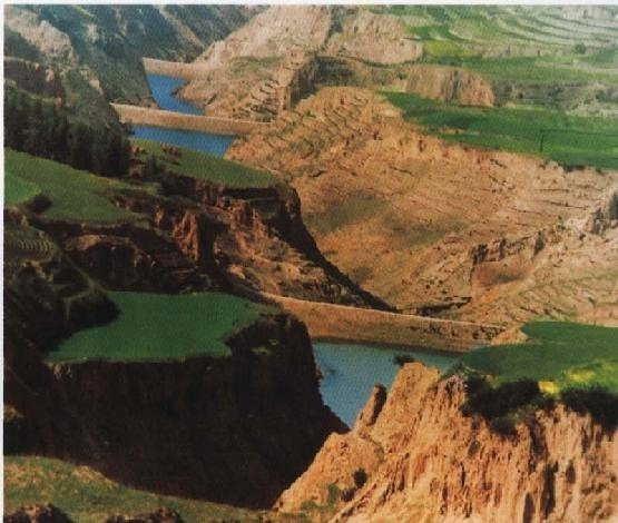
Falling water filled dams distribute widely in the middle reaches of the Yellow River, they are used to store water and wrap sediment which result from soil and water loss. On the Loess Plateau, in addition to the conditions of deep gully and steep slope, earth above the top of the dams can be used to build dams. First, soil is loosed with squirt guns, exploded or manually dug. Then, water is pumped up to the loose earth so as to rush the soil down along transporting ditch, turning the soil into dense mud to dam level surrounded by tamped banks. Under the press of gravity, the mud dehydrates, consolidates and becomes uniformly dense body of the dams. Compared with dams in other areas, the water power filled dams in the Yellow River basin are characterized by much denser mud, uniform particles and body texture, smaller transect of dams body, and wide applicability to soil materials such as sand soil, loess soil and weathering residue. The types of dams have widely applied to build moderate and small reservoirs and silt arresters in the middle reaches of the Yellow River, they play an important role in increase in agricultural production and reduction of sediment into the Yellow River.
2.3 Photos de la Technologie
Galerie Médias
2.5 Pays/ région/ lieux où la Technologie a été appliquée et qui sont couverts par cette évaluation
Pays:
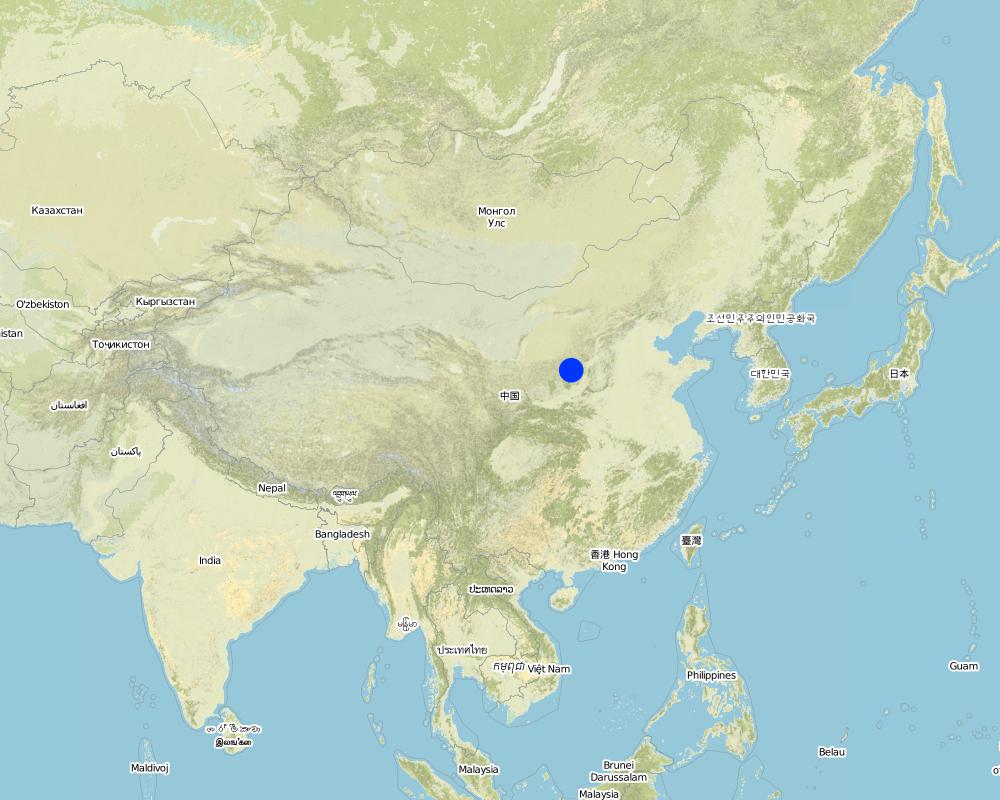
Chine
Région/ Etat/ Province:
Shanxi, Shaanxi, etc.
Spécifiez la diffusion de la Technologie:
- répartie uniformément sur une zone
Si la Technologie est uniformément répartie sur une zone, précisez la superficie couverte (en km2):
13062,0
S'il n'existe pas d'informations exactes sur la superficie, indiquez les limites approximatives de la zone couverte:
- > 10 000 km2
Commentaires:
Total area covered by the SLM Technology is 13062 km2.
Dams filled by water power are applied mainly in the middle reach of the Yellow River, including the provinces of Shanxi, Shaanxi, Inner Mongolia, Ningxia, Gansu, Qinghai, Henan, etc. The types of dams were used since 1950s, and most the dams being used were built in 1970s.
Map
×2.6 Date de mise en œuvre de la Technologie
Si l'année précise est inconnue, indiquez la date approximative: :
- il y a plus de 50 ans (technologie traditionnelle)
2.7 Introduction de la Technologie
Spécifiez comment la Technologie a été introduite: :
- dans le cadre d'un système traditionnel (> 50 ans)
Commentaires (type de projet, etc.) :
The technology was developed by local people during the conservation practice in 1950s.
3. Classification de la Technologie de GDT
3.1 Principal(aux) objectif(s) de la Technologie
- améliorer la production
3.2 Type(s) actuel(s) d'utilisation des terres, là où la Technologie est appliquée

Terres cultivées
- Cultures annuelles
Nombre de période de croissance par an: :
- 1
Précisez:
Longest growing period in days: 165Longest growing period from month to month: May - Sep

Voies d'eau, plans d'eau, zones humides
- Etangs, barrages, retenues d'eau
Principaux produits/ services:
Auto-Flowing Slurry Dam
Commentaires:
Major land use problems (compiler’s opinion): 1. Slope land is used as cropland
2. Too little ground cover to protect soil from erosion
3. Over grazing in wind erosion area
Major land use problems (land users’ perception): 1. Little cropland for food supply
2. The land productivity is too low
3. The benefit of returning cropland to graze land or woodland is not definite now except the compensate from government
3.5 Groupe de GDT auquel appartient la Technologie
- gestion de l'irrigation (incl. l'approvisionnement en eau, le drainage)
3.6 Mesures de GDT constituant la Technologie

structures physiques
- S5: Barrages/retenues, micro-bassins, étangs
Commentaires:
Main measures: structural measures
3.7 Principaux types de dégradation des terres traités par la Technologie

érosion hydrique des sols
- Wt: perte de la couche superficielle des sols (couche arable)/ érosion de surface
- Wg: ravinement/ érosion en ravines

érosion éolienne des sols
- Et: perte de la couche superficielle des sols (couche arable)

dégradation chimique des sols
- Cn: baisse de la fertilité des sols et réduction du niveau de matière organique (non causée par l’érosion)

dégradation hydrique
- Ha: aridification
Commentaires:
Main type of degradation addressed: Wg: gully erosion / gullying, Ha: aridification
Secondary types of degradation addressed: Wt: loss of topsoil / surface erosion, Et: loss of topsoil, Cn: fertility decline and reduced organic matter content
Main causes of degradation: other natural causes (avalanches, volcanic eruptions, mud flows, highly susceptible natural resources, extreme topography, etc.) specify, poverty / wealth (Lack of captial), education, access to knowledge and support services (Lack of knowledge)
3.8 Prévention, réduction de la dégradation ou réhabilitation des terres dégradées
Spécifiez l'objectif de la Technologie au regard de la dégradation des terres:
- non applicable
4. Spécifications techniques, activités, intrants et coûts de mise en œuvre
4.1 Dessin technique de la Technologie
Spécifications techniques (associées au dessin technique):
Technical knowledge required for field staff / advisors: low
Technical knowledge required for land users: low
Main technical functions: control of concentrated runoff: retain / trap, water harvesting / increase water supply, sediment retention / trapping, sediment harvesting
Secondary technical functions: control of raindrop splash, control of dispersed runoff: retain / trap, control of dispersed runoff: impede / retard, control of concentrated runoff: impede / retard, control of concentrated runoff: drain / divert, reduction of slope angle, reduction of slope length, improvement of ground cover, increase of surface roughness, increase in organic matter, increase of infiltration, increase / maintain water stored in soil, water spreading, reduction in wind speed, increase in soil fertility, improvement of soil structure
Construction material (earth): Loess earth
Slope (which determines the spacing indicated above): 45%
If the original slope has changed as a result of the Technology, the slope today is: 30%
Lateral gradient along the structure: 60%
For water harvesting: the ratio between the area where the harvested water is applied and the total area from which water is collected is: 1:1
4.2 Informations générales sur le calcul des intrants et des coûts
Indiquez la monnaie utilisée pour le calcul des coûts:
- dollars américains
Indiquez le coût salarial moyen de la main d'œuvre par jour:
3.00
4.3 Activités de mise en place/ d'établissement
| Activité | Calendrier des activités (saisonnier) | |
|---|---|---|
| 1. | preparing earth | n/a |
| 2. | pumping water | n/a |
| 3. | preparing base of the dam and its perimetric banks | n/a |
| 4. | Flushing the prepared earth with water inside the banks of the dam | 0.1~1 |
| 5. | After dehydration and consolidation of the earth, repeat 3 and 4. | n/a |
4.4 Coûts et intrants nécessaires à la mise en place
Commentaires:
Duration of establishment phase: 540 month(s)
4.5 Activités d'entretien/ récurrentes
| Activité | Calendrier/ fréquence | |
|---|---|---|
| 1. | Keeping the top of the dam level and free of crevice, water or rubbish | timely |
| 2. | Keeping the top of the dam level and free of crevice, water or rubbish | |
| 3. | Keeping the slope of the dam compact and free of rill or weed. | timely |
| 4. | Keeping the slope of the dam compact and free of rill or weed. | |
| 5. | Keeping the observation equipment work in order. | timely |
| 6. | Keeping the observation equipment work in order. | |
| 7. | Preventing the base the dam from destroying by white ants and other animals. | April to October/once a year |
4.6 Coûts et intrants nécessaires aux activités d'entretien/ récurrentes (par an)
Commentaires:
The volume of structure.
4.7 Facteurs les plus importants affectant les coûts
Décrivez les facteurs les plus importants affectant les coûts :
Since the dam construction uses local materials, the most important factors affecting the cost are labor and equipment
5. Environnement naturel et humain
5.1 Climat
Précipitations annuelles
- < 250 mm
- 251-500 mm
- 501-750 mm
- 751-1000 mm
- 1001-1500 mm
- 1501-2000 mm
- 2001-3000 mm
- 3001-4000 mm
- > 4000 mm
Zone agro-climatique
- semi-aride
- aride
5.2 Topographie
Pentes moyennes:
- plat (0-2 %)
- faible (3-5%)
- modéré (6-10%)
- onduleux (11-15%)
- vallonné (16-30%)
- raide (31-60%)
- très raide (>60%)
Reliefs:
- plateaux/ plaines
- crêtes
- flancs/ pentes de montagne
- flancs/ pentes de colline
- piémonts/ glacis (bas de pente)
- fonds de vallée/bas-fonds
Zones altitudinales:
- 0-100 m
- 101-500 m
- 501-1000 m
- 1001-1500 m
- 1501-2000 m
- 2001-2500 m
- 2501-3000 m
- 3001-4000 m
- > 4000 m
Indiquez si la Technologie est spécifiquement appliquée dans des:
- non pertinent
Commentaires et précisions supplémentaires sur la topographie:
Landform: Also plateau/plain
5.3 Sols
Profondeur moyenne du sol:
- très superficiel (0-20 cm)
- superficiel (21-50 cm)
- modérément profond (51-80 cm)
- profond (81-120 cm)
- très profond (>120 cm)
Texture du sol (de la couche arable):
- moyen (limoneux)
- fin/ lourd (argile)
Matière organique de la couche arable:
- moyen (1-3%)
- faible (<1%)
Si disponible, joignez une description complète du sol ou précisez les informations disponibles, par ex., type de sol, pH/ acidité du sol, capacité d'échange cationique, azote, salinité, etc.
Soil fertility: low
Soil drainage / infiltration: medium - good
Soil water storage capacity: high - very high
5.6 Caractéristiques des exploitants des terres appliquant la Technologie
Revenus hors exploitation:
- 10-50% de tous les revenus
Niveau relatif de richesse:
- moyen
- riche
Indiquez toute autre caractéristique pertinente des exploitants des terres:
Population density: 50-100 persons/km2
Annual population growth: 0.5% - 1%
Relative level of wealth: rich, average, poor
There are almost no people very rich in the area.
Rich people are as same as average people.
40% of the land users are average wealthy and own 20% of the land (Average people in the area where the SWC is applied should offer labor for the construction.).
Poor people can offer labor for the construction.
Very poor people are relatively rare and they are often in poor health.
Off-farm income specification: Most young male farmers often go to the city or town to earn money
5.8 Propriété foncière, droits d’utilisation des terres et de l'eau
Propriété foncière:
- état
Droits d’utilisation des terres:
- accès libre (non organisé)
- communautaire (organisé)
6. Impacts et conclusions
6.1 Impacts sur site que la Technologie a montrés
Impacts écologiques
Cycle de l'eau/ ruissellement
ruissellement de surface
Quantité avant la GDT:
43
Quantité après la GDT:
35
Sols
perte en sol
Quantité avant la GDT:
80
Quantité après la GDT:
21
6.4 Analyse coûts-bénéfices
Quels sont les bénéfices comparativement aux coûts de mise en place (du point de vue des exploitants des terres)?
Rentabilité à court terme:
positive
Rentabilité à long terme:
très positive
Quels sont les bénéfices comparativement aux coûts d'entretien récurrents (du point de vue des exploitants des terres)?
Rentabilité à court terme:
positive
Rentabilité à long terme:
très positive
6.5 Adoption de la Technologie
- 1-10%
Si disponible, quantifiez (nombre de ménages et/ou superficie couverte):
80'000 households (3 percent of the area)
De tous ceux qui ont adopté la Technologie, combien d'entre eux l'ont fait spontanément, à savoir sans recevoir aucune incitation matérielle, ou aucune rémunération? :
- 11-50%
Commentaires:
5% of land user families have adopted the Technology with external material support
50000 land user families have adopted the Technology with external material support
Comments on acceptance with external material support: estimates
1% of land user families have adopted the Technology without any external material support
30000 land user families have adopted the Technology without any external material support
Comments on spontaneous adoption: estimates
There is a strong trend towards spontaneous adoption of the Technology
Comments on adoption trend: Although the local people adopt the SWC Technology willingly, it is usually invested, designed and constructed by the land owner, the local government.
7. Références et liens
7.1 Méthodes/ sources d'information
7.2 Références des publications disponibles
Titre, auteur, année, ISBN:
Special Planning Of Soil And Water Conservation in Xinzhou Region , Shanxi Province. 1986-1990.
Disponible à partir d'où? Coût?
Library of the Resource and Environmental Department, Beijing Normal University.
Titre, auteur, année, ISBN:
How to design the dry masonry dam in the Hanjiachuan watershed. Tianyuzhu, Wangzuliang. Beijing. Water conservation in Beijing. 2000.
Disponible à partir d'où? Coût?
Library of the Resource and Environmental Department, Beijing Normal University.
Liens et modules
Développer tout Réduire toutLiens
Falling Water Dam [Chine]
The falling water dams are widely built in the middle reach of the Yellow River, the typical dams are filled with dense slurry by water flow from upland. The approach is implemented mainly by government investment.
- Compilateur : Yan ZHANG
Modules
Aucun module trouvé