Improved terraces [Népal]
- Création :
- Mise à jour :
- Compilateur : Madhav Dhakal
- Rédacteur : –
- Examinateurs : David Streiff, Alexandra Gavilano
GARA SUDHAR- Nepali
technologies_1499 - Népal
Voir les sections
Développer tout Réduire tout1. Informations générales
1.2 Coordonnées des personnes-ressources et des institutions impliquées dans l'évaluation et la documentation de la Technologie
Spécialiste GDT:
Spécialiste GDT:
Shreshta Bhubhan
PARDYP/ICIMOD
Népal
Spécialiste GDT:
Nakarmi Gopal
PARDYP/ICIMOD
Népal
Spécialiste GDT:
Merz Juerg
PARDYP/ICIMOD
Suisse
Spécialiste GDT:
Shrestha Smriti
PARDYP/ICIMOD
Népal
Spécialiste GDT:
Adhikari Krishna.Raj
PARDYP/ICIMOD
Népal
Spécialiste GDT:
Shah P.B.
PARDYP/ICIMOD
Népal
Spécialiste GDT:
Bhuchar Sanjeev
PARDYP/ICIMOD
Népal
Spécialiste GDT:
Singh Bijendra K
District Soil Conservation Office Dhulikhel
Népal
exploitant des terres:
Thapa Kalpana
Népal
exploitant des terres:
Thapa Gore
Népal
exploitant des terres:
Thapa Leela
Népal
exploitant des terres:
Tamang Indra
Népal
Spécialiste GDT:
Nom du projet qui a facilité la documentation/ l'évaluation de la Technologie (si pertinent)
People and Resource Dynamics Project, Nepal (PARDYP)Nom du ou des institutions qui ont facilité la documentation/ l'évaluation de la Technologie (si pertinent)
ICIMOD International Centre for Integrated Mountain Development (ICIMOD) - NépalNom du ou des institutions qui ont facilité la documentation/ l'évaluation de la Technologie (si pertinent)
District Soil Conservation Office (DSCO) - Népal1.3 Conditions relatives à l'utilisation par WOCAT des données documentées
Le compilateur et la(les) personne(s) ressource(s) acceptent les conditions relatives à l'utilisation par WOCAT des données documentées:
Oui
2. Description de la Technologie de GDT
2.1 Courte description de la Technologie
Définition de la Technologie:
Hillside forward-sloping terracing and stabilisation using structural and vegetative measures
2.2 Description détaillée de la Technologie
Description:
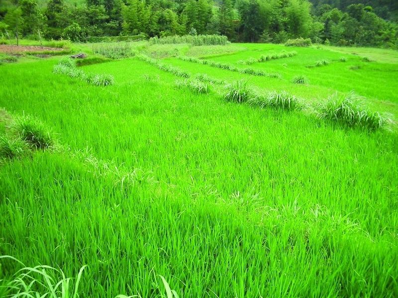
This technology addresses the soil erosion and water runoff problems associated with traditional outward-sloping terraces by reshaping the land into a series of level or gently sloping platforms across the slope. This technology is a variant of sloping land agricultural technology (SALT) or contour hedgerow technology. Nitrogen-fixing hedgerow species and quality fodder grass species, which bind the soil, are cultivated along terrace riser margins to improve terrace stability. This also enhances soil fertility and increases fodder availability. The plants are grown in either single or multiple layers. The practice is applied under rainfed conditions and is culturally acceptable and affordable. After establishment, the technology also addresses the problems of fodder scarcity making it easier and less time consuming for women and girls to gather fodder.
The hedgerow and grass species are established between January and June. Complete establishment of this technology may take one year. The first step in creating the terraces is to build retaining walls using cement bags filled with soil which are then supported with bamboo cuttings along the contour (= future terrace risers). This divides the land into the planned terrace sections. The length and width of the terraces depends on the size and shape of the original field. Secondly, the soil is excavated from the upper part of the terraces and is used to build up the lower part above and behind the terrace riser wall to create a level bed. The fertile top soil must be kept aside and later spread over the newly terraced fields. The final step is to plant grass and hedgerow species on the outermost margins of the terrace above the risers.
Maintenance involves slicing the terrace risers once or twice a year with a spade, and smoothing off rills that appear on the surface of terraces after the premonsoon and monsoon periods. Hedgerows should be cut regularly but not more than twice a year, normally to a height of about 50 cm. Grasses should be cut about once to twice a month depending on their rate of growth.
The technology is applied under humid subtropical climate conditions (1300 mm annual rainfall with about 80% of it falling in the monsoon months of June - September). The case study area has hill slopes of 16-30% that are mostly highly erodible red soils (FAO classification: luvisols).
2.3 Photos de la Technologie
Galerie Médias
2.5 Pays/ région/ lieux où la Technologie a été appliquée et qui sont couverts par cette évaluation
Pays:
Népal
Autres spécifications du lieu:
Hokse VDC ward no2
Spécifiez la diffusion de la Technologie:
- répartie uniformément sur une zone
Si la Technologie est uniformément répartie sur une zone, précisez la superficie couverte (en km2):
0,0126
S'il n'existe pas d'informations exactes sur la superficie, indiquez les limites approximatives de la zone couverte:
- < 0,1 km2 (10 ha)
Commentaires:
Total area covered by the SLM Technology is 0.0126 km2.
The technology has been evaluated on the bases of village as a unit. Therefore the values calculated in terms of land use percentages is on the bases of village( Kubinde) data.
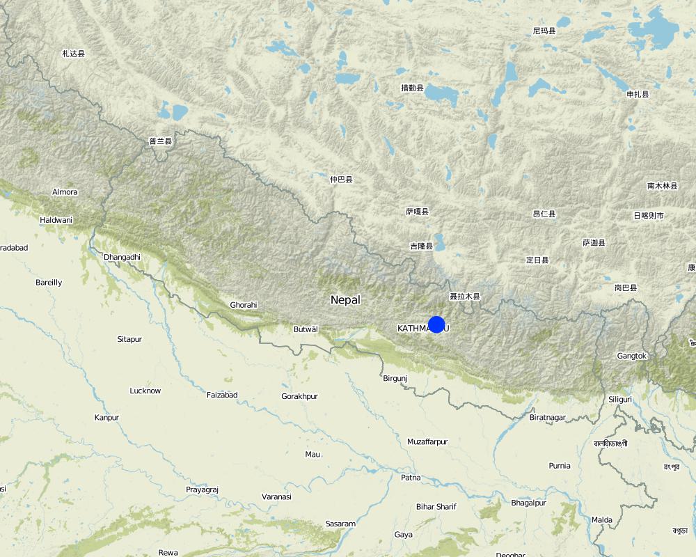
Map
×2.6 Date de mise en œuvre de la Technologie
Si l'année précise est inconnue, indiquez la date approximative: :
- il y a plus de 50 ans (technologie traditionnelle)
2.7 Introduction de la Technologie
Spécifiez comment la Technologie a été introduite: :
- par le biais de projets/ d'interventions extérieures
Commentaires (type de projet, etc.) :
It is a combination of traditional knowledge and practice along with new scientific research findings from within the region and elsewhere, e.g., N-fixing fodder species related information from Phillipines.
3. Classification de la Technologie de GDT
3.1 Principal(aux) objectif(s) de la Technologie
- réduire, prévenir, restaurer les terres dégradées
3.2 Type(s) actuel(s) d'utilisation des terres, là où la Technologie est appliquée

Terres cultivées
- Cultures annuelles
Cultures annuelles - Précisez les cultures:
- céréales - maïs
- légumineuses et légumes secs - fèves
- plantes à racines et à tubercules - pommes de terre
- wheat, chili, tomatoes
Nombre de période de croissance par an: :
- 3
Précisez:
Longest growing period in days: 150; Longest growing period from month to month: Jun - Oct; Second longest growing period in days: 120; Second longest growing period from month to month: Nov - Feb
Commentaires:
Major cash crop: Potato and tomato
Major food crop: Maize and wheat
Other: Beans and chilli
Major land use problems (compiler’s opinion): The major land use problem in the area documented is the small per capita cropping landholding size. The fields are mostly rainfed and have low soil fertility and acidity problems and are susceptible to erosion. The high intensity of rainfall leads to considerable soil loss (rill and gully erosion) at the beginning of rainy seasons.
Major land use problems (land users’ perception): The production of the cultivable land is declining. Management of slopes is inappropriate, the farmers experience serious constraints in terms of adopting better farming options, e.g., cash crops (due to fertility / erosion and soil moisture problems).
Type of cropping system and major crops comments: Rice Premonsoon and monsoon( March- Novevember ) or Maize intercropped with Beans (April to August) ,Wheat and Potato ( September to January/ February) ,Tomato (January/February- April)
3.4 Approvisionnement en eau
Approvisionnement en eau des terres sur lesquelles est appliquée la Technologie:
- pluvial
3.5 Groupe de GDT auquel appartient la Technologie
- mesures en travers de la pente
- dérivation et drainage de l'eau
3.6 Mesures de GDT constituant la Technologie

pratiques végétales
- V1: Couverture d’arbres et d’arbustes

structures physiques
- S1: Terrasses
3.7 Principaux types de dégradation des terres traités par la Technologie

érosion hydrique des sols
- Wt: perte de la couche superficielle des sols (couche arable)/ érosion de surface
- Wg: ravinement/ érosion en ravines

dégradation hydrique
- Ha: aridification
Commentaires:
Main type of degradation addressed: Wt: loss of topsoil / surface erosion, Wg: gully erosion / gullying
Secondary types of degradation addressed: Ha: aridification
Main causes of degradation: other natural causes (avalanches, volcanic eruptions, mud flows, highly susceptible natural resources, extreme topography, etc.) specify (Soil erosion due to high intensity rainfall during rainy season and uneven distribution of rainfall during lean season.), education, access to knowledge and support services (lack of knowledge - with regards to SWC measures)
Secondary causes of degradation: other human induced causes (specify) (agricultural causes - lack of improved farming options), poverty / wealth (lack of captial - realted to inmproved seeds, technologies etc.)
3.8 Prévention, réduction de la dégradation ou réhabilitation des terres dégradées
Spécifiez l'objectif de la Technologie au regard de la dégradation des terres:
- réduire la dégradation des terres
4. Spécifications techniques, activités, intrants et coûts de mise en œuvre
4.1 Dessin technique de la Technologie
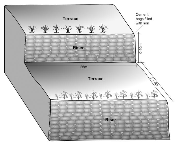
Spécifications techniques (associées au dessin technique):
Schematric view after intervention [terracing and vegetative measures]
Riser slope: 75 degree
Terrace slope: ~ 2 degree
Location: Kubinde
Technical knowledge required for field staff / advisors: high
Technical knowledge required for land users: moderate
Main technical functions: control of concentrated runoff: impede / retard, reduction of slope angle, reduction of slope length
Secondary technical functions: increase of infiltration, increase / maintain water stored in soil, increase in soil fertility
Vegetative measure: on risers
Vegetative material: T : trees / shrubs, G : grass
Number of plants per (ha): 2500
Vertical interval between rows / strips / blocks (m): 1.5
Spacing between rows / strips / blocks (m): 3 to 4
Vertical interval within rows / strips / blocks (m): 0.25
Vegetative measure: Vegetative material: T : trees / shrubs, G : grass
Vegetative measure: Vegetative material: T : trees / shrubs, G : grass
Vegetative measure: Vegetative material: T : trees / shrubs, G : grass
Trees/ shrubs species: Sunhemp(Crotalaria juncea),Tephrosia (Tephrosia candida) and Flemingia (Flemingia microphylla)
Grass species: Napier(Pennisetum purpureum),Molasses (Melinis minutiflora) and Stylo(Stylosanthes guianensis)
Slope (which determines the spacing indicated above): 5.00%
If the original slope has changed as a result of the Technology, the slope today is (see figure below): 5.00%
Gradient along the rows / strips: 75.00%
Terrace: bench level
Vertical interval between structures (m): 1.5
Width of ditches/pits/dams (m): 3-4
Length of ditches/pits/dams (m): 10-15
Construction material (earth): Cement bag filled with soil, Bamboo nets were used to make risers.
Slope (which determines the spacing indicated above): 30%
If the original slope has changed as a result of the Technology, the slope today is: 5%
Vegetation is used for stabilisation of structures.
Auteur:
Madhav Dhakal, A. K. Thaku
4.2 Informations générales sur le calcul des intrants et des coûts
Indiquez la monnaie utilisée pour le calcul des coûts:
- dollars américains
Indiquez le taux de change des USD en devise locale, le cas échéant (p.ex. 1 USD = 79.9 réal brésilien): 1 USD = :
-1,0
Indiquez le coût salarial moyen de la main d'œuvre par jour:
1.40
4.3 Activités de mise en place/ d'établissement
| Activité | Calendrier des activités (saisonnier) | |
|---|---|---|
| 1. | Area estimation ( for vegetative measures) | before rainy seasonn/lean period (February) |
| 2. | Selection of fodder grass species | Before rainy season (Feb) |
| 3. | Planting of grasses and hedgerow species on the outward margins | During rainy season. |
| 4. | Establishment of riser, using cement bags (filled with soil) and bamboo culms for terrace stabilisation | Beginning of rainy season(May) |
| 5. | Terrace leveling:The length and width of the terraces depends on the size and shape of the field. Excavate soil from the upper part of the terrace field and use it to build up the lower part behind the terrace riser wallt creat a level plateform/bed. | Beginning of rainy season(May) |
4.4 Coûts et intrants nécessaires à la mise en place
| Spécifiez les intrants | Unité | Quantité | Coûts par unité | Coût total par intrant | % du coût supporté par les exploitants des terres | |
|---|---|---|---|---|---|---|
| Main d'œuvre | Labour | ha | 1,0 | 970,0 | 970,0 | 50,0 |
| Equipements | Total costs | ha | 1,0 | 92,0 | 92,0 | 100,0 |
| Matériel végétal | Seeds | ha | 1,0 | 25,0 | 25,0 | |
| Matériel végétal | Seedlings | ha | 1,0 | 30,0 | 30,0 | |
| Matériel végétal | Bamboo | culms | 80,0 | 1,0 | 80,0 | 50,0 |
| Matériaux de construction | Cement bags | ha | 1,0 | 80,0 | 80,0 | 50,0 |
| Autre | Supervision charge | ha | 1,0 | 10,5 | 10,5 | |
| Coût total de mise en place de la Technologie | 1287,5 | |||||
| Coût total de mise en place de la Technologie en dollars américains (USD) | -1287,5 | |||||
Commentaires:
Duration of establishment phase: 12 month(s)
4.5 Activités d'entretien/ récurrentes
| Activité | Calendrier/ fréquence | |
|---|---|---|
| 1. | Hedgerow/grass maintenance: Hedgerows are cut regularly but not | Grass is cut once or twice a month. |
| 2. | (Re)plantation of hedge species if necessary | Before monsoon /1*/year |
| 3. | Surface and riser maintenance: smooth the surface/rills on the | after pre monsoon and after monsoon/2 */ year ,Jun |
4.6 Coûts et intrants nécessaires aux activités d'entretien/ récurrentes (par an)
| Spécifiez les intrants | Unité | Quantité | Coûts par unité | Coût total par intrant | % du coût supporté par les exploitants des terres | |
|---|---|---|---|---|---|---|
| Main d'œuvre | Labour | ha | 1,0 | 310,0 | 310,0 | 100,0 |
| Equipements | Tools total costs | ha | 1,0 | 20,0 | 20,0 | 100,0 |
| Matériel végétal | Seeds | ha | 1,0 | 6,0 | 6,0 | 100,0 |
| Matériel végétal | Seedlings | ha | 1,0 | 6,0 | 6,0 | 100,0 |
| Coût total d'entretien de la Technologie | 342,0 | |||||
| Coût total d'entretien de la Technologie en dollars américains (USD) | -342,0 | |||||
Commentaires:
Machinery/ tools: Spade, Shovel, spade
All costs and amounts... are very roughly estimated by the technicians and authors.
Costs for structural measures are calculated considering the volume of excavated earth. 1 cubic meter excavated earth = 0.69 USD (labour cost). For vegetative measures it is normally based on daily wage = 1.4 USD as in 2006.
Labour cost is the major expenditure in the initial stage.
costs for tools for establishment are representative for the situation when tools for implementation of the SWC technology are not available (normally they are since the technology does not require very specific tools).
4.7 Facteurs les plus importants affectant les coûts
Décrivez les facteurs les plus importants affectant les coûts :
In case of projects interested in promoting this technology in the region, the labour cost is the major expenditure in the initial stage.The labour charges are decided by the district soil conservation office.
5. Environnement naturel et humain
5.1 Climat
Précipitations annuelles
- < 250 mm
- 251-500 mm
- 501-750 mm
- 751-1000 mm
- 1001-1500 mm
- 1501-2000 mm
- 2001-3000 mm
- 3001-4000 mm
- > 4000 mm
Spécifiez la pluviométrie moyenne annuelle (si connue), en mm:
1304,00
Zone agro-climatique
- humide
Thermal climate class: subtropics
5.2 Topographie
Pentes moyennes:
- plat (0-2 %)
- faible (3-5%)
- modéré (6-10%)
- onduleux (11-15%)
- vallonné (16-30%)
- raide (31-60%)
- très raide (>60%)
Reliefs:
- plateaux/ plaines
- crêtes
- flancs/ pentes de montagne
- flancs/ pentes de colline
- piémonts/ glacis (bas de pente)
- fonds de vallée/bas-fonds
Zones altitudinales:
- 0-100 m
- 101-500 m
- 501-1000 m
- 1001-1500 m
- 1501-2000 m
- 2001-2500 m
- 2501-3000 m
- 3001-4000 m
- > 4000 m
5.3 Sols
Profondeur moyenne du sol:
- très superficiel (0-20 cm)
- superficiel (21-50 cm)
- modérément profond (51-80 cm)
- profond (81-120 cm)
- très profond (>120 cm)
Texture du sol (de la couche arable):
- fin/ lourd (argile)
Matière organique de la couche arable:
- moyen (1-3%)
- faible (<1%)
Si disponible, joignez une description complète du sol ou précisez les informations disponibles, par ex., type de sol, pH/ acidité du sol, capacité d'échange cationique, azote, salinité, etc.
Soil texture (topsoil): Clay loam
Soil fertility is low
Soil drainage / infiltration is good but when rigid surface, then low infiltration
Soil water storage capacity is low - medium
5.4 Disponibilité et qualité de l'eau
Disponibilité de l’eau de surface:
faible/ absente
Qualité de l’eau (non traitée):
faiblement potable (traitement nécessaire)
Commentaires et précisions supplémentaires sur la qualité et la quantité d'eau:
Availability of surface water: Sloping land , water available at downstream
Water quality (untreated): More in rainy season (June- September), less in April/May; source: natural spring
5.6 Caractéristiques des exploitants des terres appliquant la Technologie
Orientation du système de production:
- subsistance (auto-approvisionnement)
- exploitation mixte (de subsistance/ commerciale)
Revenus hors exploitation:
- 10-50% de tous les revenus
Niveau relatif de richesse:
- pauvre
- moyen
Individus ou groupes:
- individu/ ménage
Niveau de mécanisation:
- travail manuel
- traction animale
Genre:
- femmes
- hommes
Indiquez toute autre caractéristique pertinente des exploitants des terres:
Land users applying the Technology are mainly common / average land users
Population density: 200-500 persons/km2
Annual population growth: 2% - 3%
2% of the land users are rich and own 10% of the land.
3% of the land users are average wealthy and own 15% of the land (off farm employment).
95% of the land users are poor and own 75% of the land.
Off-farm income specification: In most farm households off-farm income plays at least a minor and increasingly a major role. Occasional opportunities for off-farm income present themselves in the form of daily
Market orientation of production system: For subsistence there is: Rice, maize and wheat. Potato and tomato are for market or subsitence as well.
Level of mechanization: Land preparaion, planting,weeding and harvest is manual labour, but land preparation can also happen with animal traction.
5.7 Superficie moyenne des terres utilisées par les exploitants des terres appliquant la Technologie
- < 0,5 ha
- 0,5-1 ha
- 1-2 ha
- 2-5 ha
- 5-15 ha
- 15-50 ha
- 50-100 ha
- 100-500 ha
- 500-1 000 ha
- 1 000-10 000 ha
- > 10 000 ha
Cette superficie est-elle considérée comme de petite, moyenne ou grande dimension (en se référant au contexte local)?
- moyenne dimension
Commentaires:
Land fragmentation due to poulation growth, mostly of rainfed type
5.8 Propriété foncière, droits d’utilisation des terres et de l'eau
Propriété foncière:
- individu, avec titre de propriété
Droits d’utilisation des terres:
- individuel
6. Impacts et conclusions
6.1 Impacts sur site que la Technologie a montrés
Impacts socio-économiques
Production
production agricole
Commentaires/ spécifiez:
maize crop by 100%
production fourragère
Commentaires/ spécifiez:
households of neighbouring village benefitted.
qualité des fourrages
surface de production
Revenus et coûts
revenus agricoles
Commentaires/ spécifiez:
by >100% due to higher
Impacts socioculturels
institutions communautaires
Commentaires/ spécifiez:
terrace improvement group was formed
Livelihood and human well-being
Commentaires/ spécifiez:
Cropping pattern changed due to which, land users were able to produce more. Farm income and price of land increased.
Impacts écologiques
Sols
humidité du sol
Commentaires/ spécifiez:
nearby hedgerows
couverture du sol
Commentaires/ spécifiez:
along risers
perte en sol
Commentaires/ spécifiez:
due to levelled surface and hedgerow barrier
Autres impacts écologiques
Appearance of pests like rats due to introduction of planted
6.2 Impacts hors site que la Technologie a montrés
inondations en aval
Commentaires/ spécifiez:
Bigger area needs swc measures
envasement en aval
Fodder grass seed distribution
Commentaires/ spécifiez:
through farmer to farmer dissemination
Nutrients downstream
Commentaires/ spécifiez:
due to reduced nutrients leaching on-site
6.3 Exposition et sensibilité de la Technologie aux changements progressifs et aux évènements extrêmes/catastrophes liés au climat (telles que perçues par les exploitants des terres)
Changements climatiques progressifs
Changements climatiques progressifs
| Saison | Augmentation ou diminution | Comment la Technologie fait-elle face à cela? | |
|---|---|---|---|
| températures annuelles | augmente | bien |
Extrêmes climatiques (catastrophes)
Catastrophes météorologiques
| Comment la Technologie fait-elle face à cela? | |
|---|---|
| pluie torrentielle locale | pas bien |
| tempête de vent locale | bien |
Catastrophes climatiques
| Comment la Technologie fait-elle face à cela? | |
|---|---|
| sécheresse | pas bien |
Catastrophes hydrologiques
| Comment la Technologie fait-elle face à cela? | |
|---|---|
| inondation générale (rivière) | pas bien |
Autres conséquences liées au climat
Autres conséquences liées au climat
| Comment la Technologie fait-elle face à cela? | |
|---|---|
| réduction de la période de croissance | bien |
6.4 Analyse coûts-bénéfices
Quels sont les bénéfices comparativement aux coûts de mise en place (du point de vue des exploitants des terres)?
Rentabilité à court terme:
neutre / équilibrée
Rentabilité à long terme:
positive
Quels sont les bénéfices comparativement aux coûts d'entretien récurrents (du point de vue des exploitants des terres)?
Rentabilité à court terme:
positive
Rentabilité à long terme:
très positive
Commentaires:
The initial investment is high, but can be recovered within a short period due to yield increment and cash crop production.
6.5 Adoption de la Technologie
- > 50%
Si disponible, quantifiez (nombre de ménages et/ou superficie couverte):
16 households in an area of 0.0126 sq km
De tous ceux qui ont adopté la Technologie, combien d'entre eux l'ont fait spontanément, à savoir sans recevoir aucune incitation matérielle, ou aucune rémunération? :
- 51-90%
Commentaires:
6 land user families have adopted the Technology with external material support
10 land user families have adopted the Technology without any external material support
Comments on spontaneous adoption: survey results
There is a little trend towards spontaneous adoption of the Technology
Comments on adoption trend: The number of farmers applying the technology is increasing without further incentives being provided. Others have shown increasing interest in the technology without implementing it due to lack of incentives.
6.7 Points forts/ avantages/ possibilités de la Technologie
| Points forts/ avantages/ possibilités du point de vue de l'exploitant des terres |
|---|
|
The price of land increased considerably from NRs 30,000 in 2001 (for 1 ropani – 508.5 sq. m) to between NRs 100, 000 and NRs 150,000 per ropani after the technology was established How can they be sustained / enhanced? The price would increase further if irrigation facilities were installed |
| Pedicels of Tephosia and Sunhemp can be used for firewood. |
| Instead of planting only maize a farmer started planting rice (primary crop) and cash crops like potato / tomato (secondary crops). |
| Points forts/ avantages/ possibilités du point de vue du compilateur ou d'une autre personne ressource clé |
|---|
|
The area of levelled terraces nearly doubled in Kubinde village from 2001 to 2003, which is an indicator of increased awareness of the benefi ts of soil and water conservation. How can they be sustained / enhanced? Experience sharing would help expand the area under improved terraces. |
|
Land productivity increased, maize, potato and bean production increased, vegetables and rice production started. How can they be sustained / enhanced? Irrigation facility could increase the production capacity of the terraces. |
|
Availability of grass/fodder (nitrogen fixing) increased. How can they be sustained / enhanced? Planting horticultural fruits could increase farm incomes and so it should be promoted and more nitrogen fi xing species (preferably local) should be tried out |
6.8 Faiblesses/ inconvénients/ risques de la Technologie et moyens de les surmonter
| Faiblesses/ inconvénients/ risques du point de vue de l’exploitant des terres | Comment peuvent-ils être surmontés? |
|---|---|
| In the fi rst year of implementation, maize production was reduced due to soil amendment |
a phenomenon which is likely to occur with new terrace formation |
| Faiblesses/ inconvénients/ risques du point de vue du compilateur ou d'une autre personne ressource clé | Comment peuvent-ils être surmontés? |
|---|---|
| Presently the vegetative technology is confined to terrace margins | it should be extended to the risers also. |
7. Références et liens
7.1 Méthodes/ sources d'information
7.2 Références des publications disponibles
Titre, auteur, année, ISBN:
ICIMOD (2002) Hydro-meteorological Year Book of Jhikhu Khola Watershed. Kathmandu: ICIMOD
Disponible à partir d'où? Coût?
ICIMOD
Titre, auteur, année, ISBN:
Mathema, P.; Singh, B.K. (2003) Soil ErosionStudies in Nepal: Results and Implications. Kathmandu: Government of Nepal, Department of Soil Conservation and Watershed Management
Titre, auteur, année, ISBN:
Mathema, P. (2003) Watershed Managementin South Asia. Kathmandu: Government of Nepal, Department of Soil Conservation and Watershed Management
Liens et modules
Développer tout Réduire toutLiens
Aucun lien
Modules
Aucun module trouvé