Land terracing in olive groves [Grèce]
- Création :
- Mise à jour :
- Compilateur : Costas Kosmas
- Rédacteur : –
- Examinateurs : Deborah Niggli, Alexandra Gavilano
Αναβαθμοί Greek
technologies_1512 - Grèce
Voir les sections
Développer tout Réduire tout1. Informations générales
1.2 Coordonnées des personnes-ressources et des institutions impliquées dans l'évaluation et la documentation de la Technologie
Spécialiste GDT:
Mentzidakis Ioannis
National Agricultural Research Foundation - NAGREF, Institute of OliveTrees and Subtropical plants
Grèce
1.3 Conditions relatives à l'utilisation par WOCAT des données documentées
Le compilateur et la(les) personne(s) ressource(s) acceptent les conditions relatives à l'utilisation par WOCAT des données documentées:
Oui
1.4 Déclaration sur la durabilité de la Technologie décrite
Est-ce que la Technologie décrite ici pose problème par rapport à la dégradation des terres, de telle sorte qu'elle ne peut pas être déclarée comme étant une technologie de gestion durable des terres?
Non
1.5 Référence au(x) Questionnaires sur les Approches de GDT (documentées au moyen de WOCAT)
Sustainable development of olive groves III [Grèce]
Aucune description disponible.
- Compilateur : Costas Kosmas
2. Description de la Technologie de GDT
2.1 Courte description de la Technologie
Définition de la Technologie:
Terraces are constructions built mainly in hilly areas to reduce water erosion losses from cultivated erodible soils and for water conservation.
2.2 Description détaillée de la Technologie
Description:
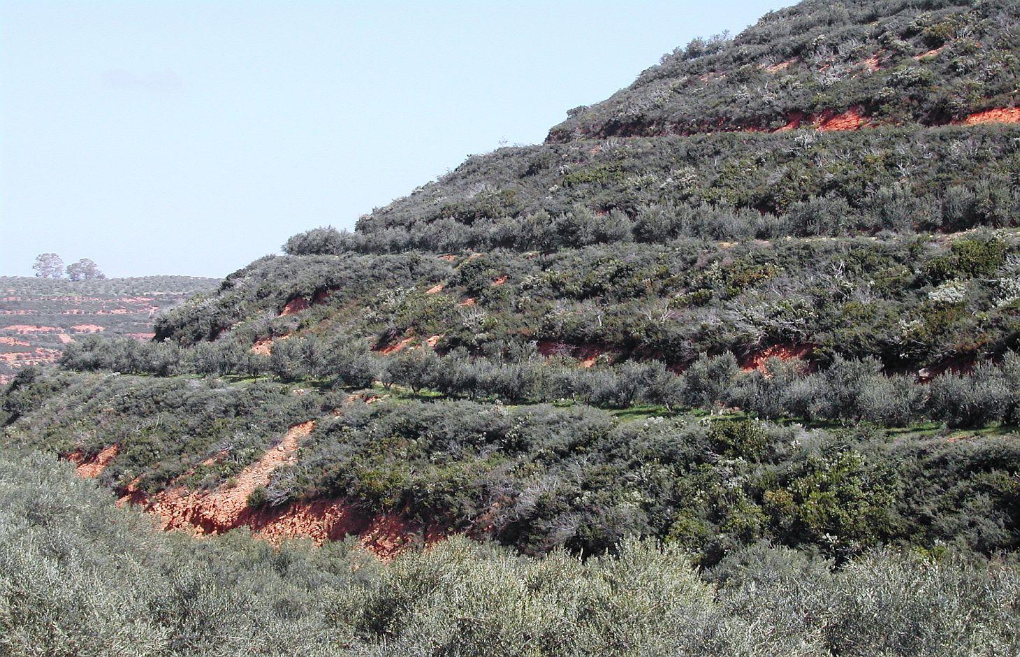
Bench terrace is the main type of terraces existing in the area of Chania. Land terracing is mainly found in the middle and upper zone of the study area and especially in steep slopes and in soils formed mainly in shale or conglomerates parent material. The land in which terraces have been constructed is estimated to 7.7% of the total area of Chania. Some bench terraces have been constructed recently in very steep slopes for cultivating the land.
Local agronomists recommend the construction of terraces as a measure for soil erosion protection in hilly areas.
The first step for construction of bench terrace is to clear the field of trash, dead furrows are filled in, and small ridges are levelled. The interval between terraces depends on soil characteristics and amount of rainfall. Usually, it is not recommended space interval narrower than 30 meters. Terrace system design usually begins with a technician evaluating the water regime of the field from observations, soil surveys, and other information. The next decision is whether waterways should follow natural draws or be constructed on new sites. The channel along the terrace for removing excess of runoff water is at least 30 to 45 cm deep and the maximum allowed gradient 0.4% for most soils to avoid serious erosion. Terrace layout begins from the highest point of the field. The vertical fall and slope gradient from the high point to the approximate site of the top terrace, usually 30 to 50 m downslope (depending on gradient), is determined with an engineering level. It is usually preferable to begin staking a terrace at the waterway and work up to the top end. Usually some stakes need to be reset to avoid short, sharp curves and to make field work parallel to the terrace easier. The first layout of a terrace system seldom achieves the most satisfactory design. Some unexpected topographical feature may show up and necessitate changing one or more terrace lines. The final terrace positions should be identified by plough furrows or other implement marks before construction begins. Conventional terraces can be built with bulldozers, motor patrol graders, carryall scrapers, elevating grader terracers, mould-board ploughs, disk tillers with 60 cm or larger disks, and with hand tools and baskets, headpans, or other carrying devices. Terraces rarely should be longer than 600 m. Terraces should not be longer than 375 m on already gullied land. Longer terraces need to be sub¬divided with an outlet provided for each segment. Terraces must be wide enough to accommodate the equipment that will be used in the field, generally not less than 4.5 m. The flatter these slopes are, the easier is to farm but the more expensive they are to build. Trees are usually planted in the upper part of the terrace. In modern terraced fields crop cultivation is fully mechanized. In such terraced fields all farm operations should carried out as nearly as parallel to the terrace as possible to minimize water and soil movement between terraces and to reduce damage to the terrace ridges. The most evident effect of tillage operations, after several years is the increase in the base width of the terrace. The best method of maintaining the shape of the terrace cross section and counteracting erosion from the inter-terraced area is by ploughing with a reversible mouldboard. In steep slopes is recommended to keep the natural vegetation in the part of the steep slope for soil erosion protection.
2.3 Photos de la Technologie
Galerie Médias
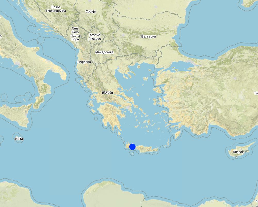
2.5 Pays/ région/ lieux où la Technologie a été appliquée et qui sont couverts par cette évaluation
Pays:
Grèce
Région/ Etat/ Province:
Selinos province
Autres spécifications du lieu:
Chania-Cete
Commentaires:
Total area covered by the SLM Technology is 55 km2.
Map
×2.6 Date de mise en œuvre de la Technologie
Si l'année précise est inconnue, indiquez la date approximative: :
- il y a plus de 50 ans (technologie traditionnelle)
2.7 Introduction de la Technologie
Spécifiez comment la Technologie a été introduite: :
- dans le cadre d'un système traditionnel (> 50 ans)
3. Classification de la Technologie de GDT
3.1 Principal(aux) objectif(s) de la Technologie
- réduire, prévenir, restaurer les terres dégradées
- préserver l'écosystème
3.2 Type(s) actuel(s) d'utilisation des terres, là où la Technologie est appliquée

Terres cultivées
- Plantations d’arbres ou de buissons
Plantations d'arbres et d'arbustes - Précisez les cultures:
- olive
Nombre de période de croissance par an: :
- 2
Précisez:
Longest growing period in days: 120, Longest growing period from month to month: March to July, Second longest growing period in days: 150, Second longest growing period from month to month: March to August
Commentaires:
Major land use problems (compiler’s opinion): Soil erosion and loss of water
Major land use problems (land users’ perception): Difficulties in cultivatiing the land and harvesting the olive fruits
Future (final) land use (after implementation of SLM Technology): Cropland: Ct: Tree and shrub cropping
Livestock is grazing on crop residues
3.3 Est-ce que l’utilisation des terres a changé en raison de la mise en œuvre de la Technologie ?
Est-ce que l’utilisation des terres a changé en raison de la mise en œuvre de la Technologie ?
- Oui (Veuillez remplir les questions ci-après au regard de l’utilisation des terres avant la mise en œuvre de la Technologie)
Les divers types d'utilisation des terres au sein du même unité de terrain: :
Oui
Précisez l'utilisation mixte des terres (cultures/ pâturages/ arbres):
- Agroforesterie
Commentaires:
Mixed: Mf: Agroforestry
3.4 Approvisionnement en eau
Approvisionnement en eau des terres sur lesquelles est appliquée la Technologie:
- pluvial
3.5 Groupe de GDT auquel appartient la Technologie
- mesures en travers de la pente
3.6 Mesures de GDT constituant la Technologie

structures physiques
- S1: Terrasses
3.7 Principaux types de dégradation des terres traités par la Technologie

érosion hydrique des sols
- Wt: perte de la couche superficielle des sols (couche arable)/ érosion de surface

dégradation hydrique
- Ha: aridification
Commentaires:
Main causes of degradation: deforestation / removal of natural vegetation (incl. forest fires) (Clearing of natural vegetation for planting olives. Natural vegetation is kept in the steep slope for soil erosion protection), inputs and infrastructure: (roads, markets, distribution of water points, other, …) (access to the field by machineries)
Secondary causes of degradation: other human induced causes (specify) (destroying soil characteristics)
3.8 Prévention, réduction de la dégradation ou réhabilitation des terres dégradées
Spécifiez l'objectif de la Technologie au regard de la dégradation des terres:
- réduire la dégradation des terres
4. Spécifications techniques, activités, intrants et coûts de mise en œuvre
4.1 Dessin technique de la Technologie
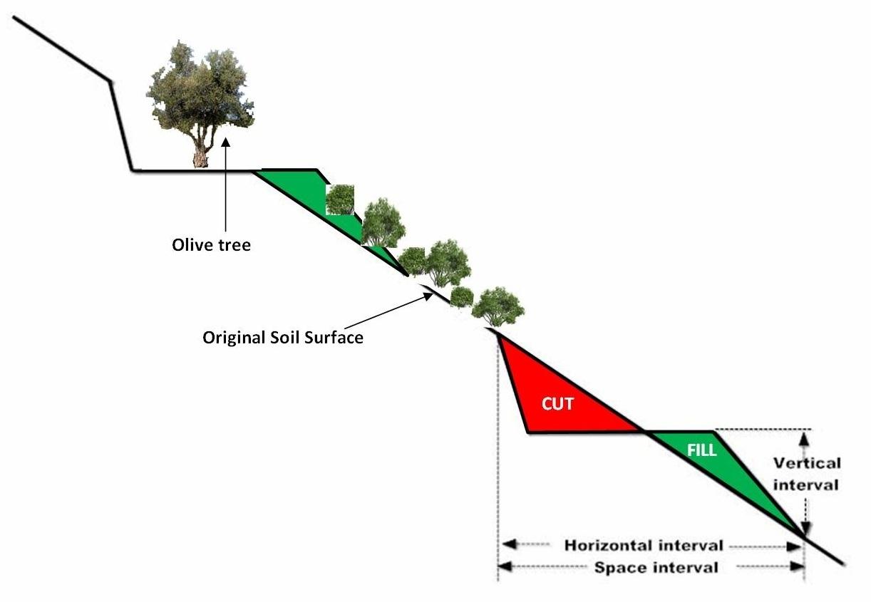
Spécifications techniques (associées au dessin technique):
Size of the terrace including bench and sloping part is 35 meters. The original slope with the natural vegetation is 64%. The bench width is 6 meters, the size of the sloping part with natural vegetation is 22 meters, and the length of the bench 145 meters. Olive trees have been planted 2 meters from upper part of the bench.
The vertical interval (VI in meters) between two adjacent terraces can be estimated by the formula given by the U.S. Soil Conservation Service: VI = xS + y. Where x is rainfall factor, S is slope gradient (%), and y is soil and cropping factor. The U.S. Soil conservation Service recommends values for x and y 0.12-0.24, and 0.3-1.2, respectively. The horizontal interval (HI in meters) can be calculated from the equation: HI = (VI/S)*100.
Location: Strovles. Crete
Date: 5/2007
Technical knowledge required for field staff / advisors: moderate (It needs planning of location of various strips and water outlets)
Technical knowledge required for land users: moderate (technical supoport)
Main technical functions: reduction of slope angle, reduction of slope length, increase / maintain water stored in soil
Secondary technical functions: stabilisation of soil (eg by tree roots against land slides)
Terrace: bench level
Spacing between structures (m): 35
Width of ditches/pits/dams (m): 6
Length of ditches/pits/dams (m): 145
Construction material (earth): Displacement of soil for constructing the bench
Slope (which determines the spacing indicated above): 65%
Lateral gradient along the structure: 65%
Auteur:
C. Kosmas
4.2 Informations générales sur le calcul des intrants et des coûts
autre/ monnaie nationale (précisez):
Euro
Indiquez le taux de change des USD en devise locale, le cas échéant (p.ex. 1 USD = 79.9 réal brésilien): 1 USD = :
1,39
Indiquez le coût salarial moyen de la main d'œuvre par jour:
80.00
4.3 Activités de mise en place/ d'établissement
| Activité | Calendrier des activités (saisonnier) | |
|---|---|---|
| 1. | Shaping the land using a bulldoze and constructing terraces, cost 1950 euro/ha | once |
4.4 Coûts et intrants nécessaires à la mise en place
| Spécifiez les intrants | Unité | Quantité | Coûts par unité | Coût total par intrant | % du coût supporté par les exploitants des terres | |
|---|---|---|---|---|---|---|
| Equipements | machine use | ha | 1,0 | 1950,0 | 1950,0 | |
| Coût total de mise en place de la Technologie | 1950,0 | |||||
| Coût total de mise en place de la Technologie en dollars américains (USD) | 1402,88 | |||||
Commentaires:
Duration of establishment phase: 24 month(s)
4.5 Activités d'entretien/ récurrentes
| Activité | Calendrier/ fréquence | |
|---|---|---|
| 1. | clearing waterways, and checking terraces for collapse, cost 60 euro/ha | once per year |
4.6 Coûts et intrants nécessaires aux activités d'entretien/ récurrentes (par an)
| Spécifiez les intrants | Unité | Quantité | Coûts par unité | Coût total par intrant | % du coût supporté par les exploitants des terres | |
|---|---|---|---|---|---|---|
| Equipements | machine use | ha | 1,0 | 60,0 | 60,0 | |
| Coût total d'entretien de la Technologie | 60,0 | |||||
| Coût total d'entretien de la Technologie en dollars américains (USD) | 43,17 | |||||
Commentaires:
Machinery/ tools: Bullldoze
year 2011
4.7 Facteurs les plus importants affectant les coûts
Décrivez les facteurs les plus importants affectant les coûts :
Slope angle, soil depth, parent material
5. Environnement naturel et humain
5.1 Climat
Précipitations annuelles
- < 250 mm
- 251-500 mm
- 501-750 mm
- 751-1000 mm
- 1001-1500 mm
- 1501-2000 mm
- 2001-3000 mm
- 3001-4000 mm
- > 4000 mm
Spécifications/ commentaires sur les précipitations:
670 mm, 6 months dry period
Zone agro-climatique
- subhumide
- semi-aride
Thermal climate class: tropics, temperate
5.2 Topographie
Pentes moyennes:
- plat (0-2 %)
- faible (3-5%)
- modéré (6-10%)
- onduleux (11-15%)
- vallonné (16-30%)
- raide (31-60%)
- très raide (>60%)
Reliefs:
- plateaux/ plaines
- crêtes
- flancs/ pentes de montagne
- flancs/ pentes de colline
- piémonts/ glacis (bas de pente)
- fonds de vallée/bas-fonds
Zones altitudinales:
- 0-100 m
- 101-500 m
- 501-1000 m
- 1001-1500 m
- 1501-2000 m
- 2001-2500 m
- 2501-3000 m
- 3001-4000 m
- > 4000 m
5.3 Sols
Profondeur moyenne du sol:
- très superficiel (0-20 cm)
- superficiel (21-50 cm)
- modérément profond (51-80 cm)
- profond (81-120 cm)
- très profond (>120 cm)
Texture du sol (de la couche arable):
- moyen (limoneux)
- fin/ lourd (argile)
Matière organique de la couche arable:
- moyen (1-3%)
5.4 Disponibilité et qualité de l'eau
Profondeur estimée de l’eau dans le sol:
> 50 m
Disponibilité de l’eau de surface:
bonne
Qualité de l’eau (non traitée):
uniquement pour usage agricole (irrigation)
5.5 Biodiversité
Diversité des espèces:
- élevé
5.6 Caractéristiques des exploitants des terres appliquant la Technologie
Orientation du système de production:
- subsistance (auto-approvisionnement)
- exploitation mixte (de subsistance/ commerciale)
Revenus hors exploitation:
- moins de 10% de tous les revenus
Niveau relatif de richesse:
- moyen
- riche
Individus ou groupes:
- individu/ ménage
Niveau de mécanisation:
- traction animale
- mécanisé/ motorisé
Genre:
- hommes
Indiquez toute autre caractéristique pertinente des exploitants des terres:
Land users applying the Technology are mainly common / average land users
Difference in the involvement of women and men: Women use to work in the house
Population density: 10-50 persons/km2
Annual population growth: 0.5% - 1%
50% of the land users are average wealthy.
5.7 Superficie moyenne des terres utilisées par les exploitants des terres appliquant la Technologie
- < 0,5 ha
- 0,5-1 ha
- 1-2 ha
- 2-5 ha
- 5-15 ha
- 15-50 ha
- 50-100 ha
- 100-500 ha
- 500-1 000 ha
- 1 000-10 000 ha
- > 10 000 ha
Cette superficie est-elle considérée comme de petite, moyenne ou grande dimension (en se référant au contexte local)?
- petite dimension
5.8 Propriété foncière, droits d’utilisation des terres et de l'eau
Propriété foncière:
- communauté/ village
- individu, avec titre de propriété
Droits d’utilisation des terres:
- individuel
Droits d’utilisation de l’eau:
- communautaire (organisé)
- individuel
5.9 Accès aux services et aux infrastructures
assistance technique:
- pauvre
- modéré
- bonne
marchés:
- pauvre
- modéré
- bonne
routes et transports:
- pauvre
- modéré
- bonne
services financiers:
- pauvre
- modéré
- bonne
6. Impacts et conclusions
6.1 Impacts sur site que la Technologie a montrés
Impacts socio-économiques
Production
production agricole
Quantité avant la GDT:
1200 kg/ha
Quantité après la GDT:
1500 kg/ha
diversité des produits
gestion des terres
Quantité avant la GDT:
120 euro/ha
Quantité après la GDT:
80 euro/ha
Revenus et coûts
revenus agricoles
Quantité avant la GDT:
3600 euro/ha
Quantité après la GDT:
4500 euro/ha
Impacts socioculturels
opportunités culturelles
possibilités de loisirs
apaisement des conflits
contribution to human well-being
Commentaires/ spécifiez:
increase farmers income and reduction the off site effects
Impacts écologiques
Cycle de l'eau/ ruissellement
quantité d'eau
Commentaires/ spécifiez:
15% more water stored into the soil
ruissellement de surface
Commentaires/ spécifiez:
75% reduction in runoff
Sols
humidité du sol
Commentaires/ spécifiez:
10% increase in soil moisture
perte en sol
Commentaires/ spécifiez:
75% reduction in soil loss
6.2 Impacts hors site que la Technologie a montrés
inondations en aval
6.3 Exposition et sensibilité de la Technologie aux changements progressifs et aux évènements extrêmes/catastrophes liés au climat (telles que perçues par les exploitants des terres)
Extrêmes climatiques (catastrophes)
Catastrophes météorologiques
| Comment la Technologie fait-elle face à cela? | |
|---|---|
| pluie torrentielle locale | pas bien |
6.4 Analyse coûts-bénéfices
Quels sont les bénéfices comparativement aux coûts de mise en place (du point de vue des exploitants des terres)?
Rentabilité à court terme:
négative
Rentabilité à long terme:
positive
Quels sont les bénéfices comparativement aux coûts d'entretien récurrents (du point de vue des exploitants des terres)?
Rentabilité à court terme:
positive
Rentabilité à long terme:
positive
6.5 Adoption de la Technologie
- > 50%
De tous ceux qui ont adopté la Technologie, combien d'entre eux l'ont fait spontanément, à savoir sans recevoir aucune incitation matérielle, ou aucune rémunération? :
- 51-90%
Commentaires:
15% of land user families have adopted the Technology with external material support
150 land user families have adopted the Technology with external material support
85% of land user families have adopted the Technology without any external material support
240 land user families have adopted the Technology without any external material support
There is a moderate trend towards spontaneous adoption of the Technology
6.7 Points forts/ avantages/ possibilités de la Technologie
| Points forts/ avantages/ possibilités du point de vue de l'exploitant des terres |
|---|
| increase of farmers income from the land exploitation in less favourable areas |
| Points forts/ avantages/ possibilités du point de vue du compilateur ou d'une autre personne ressource clé |
|---|
| Land terracing is one of the soil conservation and cultivation techniques for combating land desertification . It is a practice applied to reduce rainfall runoff on sloping land, from accumulating and causing serious problems of soil erosion. Terraces, usually allow better management of soil and water, improve access to land and facilitate farm operations. |
6.8 Faiblesses/ inconvénients/ risques de la Technologie et moyens de les surmonter
| Faiblesses/ inconvénients/ risques du point de vue de l’exploitant des terres | Comment peuvent-ils être surmontés? |
|---|---|
| Planning of land terracing | Local institutes and experts to help them |
| Faiblesses/ inconvénients/ risques du point de vue du compilateur ou d'une autre personne ressource clé | Comment peuvent-ils être surmontés? |
|---|---|
| Disturbing natural environment and landscapes | Better planning |
7. Références et liens
7.1 Méthodes/ sources d'information
- visites de terrain, enquêtes sur le terrain
- interviews/entretiens avec les exploitants des terres
Quand les données ont-elles été compilées (sur le terrain)?
07/02/2011
Liens et modules
Développer tout Réduire toutLiens
Sustainable development of olive groves III [Grèce]
Aucune description disponible.
- Compilateur : Costas Kosmas
Modules
Aucun module trouvé