Agroforestry community garden [Sénégal]
- Création :
- Mise à jour :
- Compilateur : Julie Zähringer
- Rédacteur : –
- Examinateur : Fabian Ottiger
technologies_1566 - Sénégal
Voir les sections
Développer tout Réduire tout1. Informations générales
1.2 Coordonnées des personnes-ressources et des institutions impliquées dans l'évaluation et la documentation de la Technologie
Spécialiste GDT:
Nom du ou des institutions qui ont facilité la documentation/ l'évaluation de la Technologie (si pertinent)
CDE Centre for Development and Environment (CDE Centre for Development and Environment) - SuisseNom du ou des institutions qui ont facilité la documentation/ l'évaluation de la Technologie (si pertinent)
CSE (CSE) - Sénégal1.3 Conditions relatives à l'utilisation par WOCAT des données documentées
Quand les données ont-elles été compilées (sur le terrain)?
04/08/2009
Le compilateur et la(les) personne(s) ressource(s) acceptent les conditions relatives à l'utilisation par WOCAT des données documentées:
Oui
2. Description de la Technologie de GDT
2.1 Courte description de la Technologie
Définition de la Technologie:
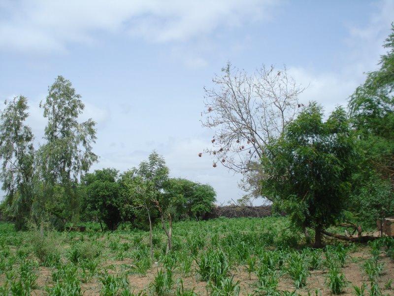
A plot under agroforestry with a rotation of horticulture (during the dry season) and millet (during the rainy season), enclosured and protected by a life fence of Prosopis juliflora
2.2 Description détaillée de la Technologie
Description:
Main objectives are to increase the availability of vegetables in this zone far from the next market and to create an income source for women in the region. To mitigate the effects of wind erosion and gully formation in the plot and to protect it from cattle roaming a fence of dead wood and Prosopis juliflora seedlings has been constructed around it, which was meant to be a life fence after a certain time.
Establishment / maintenance activities and inputs: The initiative had been taken by a local "technicien agricole" which had assembled women of three villages and searched for local partenaires. The land on which the plot has been established was allocated to the group by the village chief. At the start, the project received support from the NGO Enda Tiers-Monde and the PAPEL (Projet d’Appui à l’Elévage) which has financed the construction of a small retention basin inside the plot to store water tapped from the local borehole. Each woman had the choice of construction 2m of the fence or to pay 1'000 CFA (US-Dollar: 2.25) compensation. Plot maintenance has been assured through the womens voluntary contributions. The extensive agent for "Water and Forest" has provided seedling of P. juliflora and other species on several occasions. Apart from expenses for seeds or seedlings for vegetable production the technology is not requiring any further financial inputs.
Natural / human environment: This SLM technology site is located in the sylvopastoral region of the Ferlo in the north of Sénégal. The agro-climatic zone is classified as semi-arid with mean annual precipitation of 300-400 mm. The main land use type in the area is extensive pastoralism followed by rainfed agriculture. Pastoralism is primarily practiced by transhumant Fula (Peulh) herders and further by Mauritanian Moor herders with herds of dromedaries. Vegetation cover in the area has largely been degraded due to cutting for domestic uses and cattle feeding, bushfires and overgrazing. The soil is exposed to wind erosion which carries away nutrients in the topsoil and therefore declines soil fertility. During intense rains in the rainy season, surface runoff is accelerated and leads to the formation of gullies and ravines. Quality of water sources has declined as they are being used by the local population for the purposes of body hygiene and laundry. Another factor of degradation are the oversized herds of dromedaries which consume large quantities of biomass, contribute to soil compaction due to the shape of their hooves and whose urine is perceived as noxious to the development of herb cover. Despite the various types of degradation, pastoralism and rainfed agriculture guarantee a certain food security for the local population and they have rarely experienced famines.
2.3 Photos de la Technologie
Galerie Médias
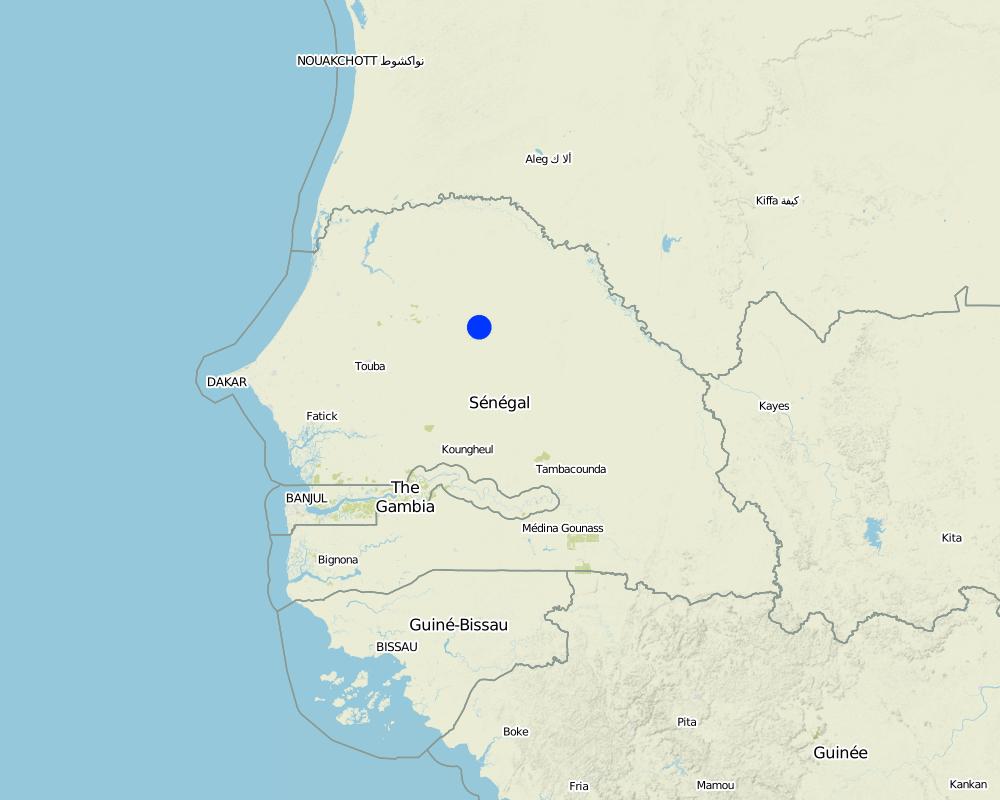
2.5 Pays/ région/ lieux où la Technologie a été appliquée et qui sont couverts par cette évaluation
Pays:
Sénégal
Région/ Etat/ Province:
Louga
Autres spécifications du lieu:
Barkédji
Map
×2.6 Date de mise en œuvre de la Technologie
Si l'année précise est inconnue, indiquez la date approximative: :
- il y a entre 10-50 ans
2.7 Introduction de la Technologie
Spécifiez comment la Technologie a été introduite: :
- grâce à l'innovation d'exploitants des terres
Commentaires (type de projet, etc.) :
1991
3. Classification de la Technologie de GDT
3.1 Principal(aux) objectif(s) de la Technologie
- améliorer la production
- réduire, prévenir, restaurer les terres dégradées
- créer un impact économique positif
3.2 Type(s) actuel(s) d'utilisation des terres, là où la Technologie est appliquée

Mixte (cultures/ pâturages/ arbres), incluant l'agroforesterie
- Agroforesterie
Principaux produits/ services:
Major cash crop annual cropping: Millet, gombo, chilli, carrot, onion
Major food crop annual cropping: Millet, gombo, chilli, carrot, onion
Major food crop tree and shrub cropping: Balanites aegyptiaca, Ziziphus mauritania
Commentaires:
Major land use problems (compiler’s opinion): degradation of vegetation cover with wind erosion as a consequence / during the rainy season intensive rainfall leads to gully and ravine formation and to accelerated surface runoff / water management: temporary ponds used for activities like laundry and body hygiene and at the same time as drinking water sources for man and cattle
Major land use problems (land users’ perception): limited access to water from borehole for irrigation purposes as cattle herds are always preferred
3.3 Informations complémentaires sur l'utilisation des terres
Approvisionnement en eau des terres sur lesquelles est appliquée la Technologie:
- pluvial
Commentaires:
Water supply: Also mixed rainfed - irrigated
Nombre de période de croissance par an: :
- 1
Précisez:
Longest growing period in days: 120 Longest growing period from month to month: Jul-Oct
3.4 Groupe de GDT auquel appartient la Technologie
- agroforesterie
- brise-vent/ plantations abris
- système de rotation (rotation des cultures, jachères, agriculture itinérante)
3.5 Diffusion de la Technologie
Spécifiez la diffusion de la Technologie:
- répartie uniformément sur une zone
Si la Technologie est uniformément répartie sur une zone, indiquez la superficie couverte approximative:
- < 0,1 km2 (10 ha)
Commentaires:
The plot located in the village of Diagali has a surface of about 0.5 ha
3.6 Mesures de GDT constituant la Technologie

pratiques végétales
- V1: Couverture d’arbres et d’arbustes
- V5: Autres
Commentaires:
Main measures: vegetative measures
Type of vegetative measures: aligned: -along boundary
3.7 Principaux types de dégradation des terres traités par la Technologie

érosion hydrique des sols
- Wg: ravinement/ érosion en ravines

érosion éolienne des sols
- Et: perte de la couche superficielle des sols (couche arable)
- Ed: déflation et déposition

dégradation biologique
- Bc: réduction de la couverture végétale

dégradation hydrique
- Ha: aridification
Commentaires:
Main type of degradation addressed: Et: loss of topsoil, Ed: deflation and deposition
Secondary types of degradation addressed: Wg: gully erosion / gullying, Bc: reduction of vegetation cover, Ha: aridification
Main causes of degradation: deforestation / removal of natural vegetation (incl. forest fires), over-exploitation of vegetation for domestic use (for domestic uses), overgrazing (oversized herds of cattle and dromadaires), population pressure, poverty / wealth (need for natural resources), education, access to knowledge and support services
Secondary causes of degradation: Heavy / extreme rainfall (intensity/amounts) (intense rains during rainy season)
3.8 Prévention, réduction de la dégradation ou réhabilitation des terres dégradées
Spécifiez l'objectif de la Technologie au regard de la dégradation des terres:
- prévenir la dégradation des terres
4. Spécifications techniques, activités, intrants et coûts de mise en œuvre
4.2 Spécification/ explications techniques du dessin technique
Technical knowledge required for field staff / advisors: moderate
Technical knowledge required for land users: moderate
Main technical functions: reduction in wind speed, increase of biomass (quantity), promotion of vegetation species and varieties (quality, eg palatable fodder)
Secondary technical functions: increase in organic matter
Aligned: -along boundary
Vegetative material: T : trees / shrubs
Number of plants per (ha): 84
Trees/ shrubs species: Prosopis juliflora (planteds)
4.3 Informations générales sur le calcul des intrants et des coûts
autre/ monnaie nationale (précisez):
CFA
Indiquer le taux de change du dollars en monnaie locale (si pertinent): 1 USD= :
455,0
4.4 Activités de mise en place/ d'établissement
| Activité | Type de mesures | Calendrier | |
|---|---|---|---|
| 1. | Establishment of tree nursery for P.juliflora | Végétale | |
| 2. | Bedding out of seedlings along plot boundary | Végétale |
4.5 Coûts et intrants nécessaires à la mise en place
| Spécifiez les intrants | Unité | Quantité | Coûts par unité | Coût total par intrant | % du coût supporté par les exploitants des terres | |
|---|---|---|---|---|---|---|
| Autre | Water | ha | 1,0 | 40,0 | 40,0 | |
| Coût total de mise en place de la Technologie | 40,0 | |||||
Si le coût n'est pas pris en charge à 100% par l'exploitant des terres, indiquez qui a financé le coût restant:
NGO Enda Tiers-Monde, Papel and the governement agent for water and forest
4.6 Activités d'entretien/ récurrentes
| Activité | Type de mesures | Calendrier/ fréquence | |
|---|---|---|---|
| 1. | Pruning of P.juliflora | Végétale | |
| 2. | Growing more seedlings in tree nursery to improve strenght of fence | Végétale |
4.7 Coûts et intrants nécessaires aux activités d'entretien/ récurrentes (par an)
Commentaires:
The cost of water applies to the need of the 0.5 ha plot and is only important in dry season when there is no other sources of water in the area. There is no other costs for the vegetation measures, as seedlings are given by the extensive agent for "Water and Forest" and all the women work on a voluntary basis
4.8 Facteurs les plus importants affectant les coûts
Décrivez les facteurs les plus importants affectant les coûts :
water from borehole for watering of seedlings in tree nursery
5. Environnement naturel et humain
5.1 Climat
Précipitations annuelles
- < 250 mm
- 251-500 mm
- 501-750 mm
- 751-1000 mm
- 1001-1500 mm
- 1501-2000 mm
- 2001-3000 mm
- 3001-4000 mm
- > 4000 mm
Spécifications/ commentaires sur les précipitations:
300-400 mm during one rainy season / dry season 8-9 months
Zone agro-climatique
- semi-aride
Thermal climate class: tropics, sylvopastoral zone of the Ferlo
5.2 Topographie
Pentes moyennes:
- plat (0-2 %)
- faible (3-5%)
- modéré (6-10%)
- onduleux (11-15%)
- vallonné (16-30%)
- raide (31-60%)
- très raide (>60%)
Reliefs:
- plateaux/ plaines
- crêtes
- flancs/ pentes de montagne
- flancs/ pentes de colline
- piémonts/ glacis (bas de pente)
- fonds de vallée/bas-fonds
Zones altitudinales:
- 0-100 m
- 101-500 m
- 501-1000 m
- 1001-1500 m
- 1501-2000 m
- 2001-2500 m
- 2501-3000 m
- 3001-4000 m
- > 4000 m
5.3 Sols
Profondeur moyenne du sol:
- très superficiel (0-20 cm)
- superficiel (21-50 cm)
- modérément profond (51-80 cm)
- profond (81-120 cm)
- très profond (>120 cm)
Texture du sol (de la couche arable):
- grossier/ léger (sablonneux)
- moyen (limoneux)
Matière organique de la couche arable:
- moyen (1-3%)
Si disponible, joignez une description complète du sol ou précisez les informations disponibles, par ex., type de sol, pH/ acidité du sol, capacité d'échange cationique, azote, salinité, etc.
Soil texture: Coarse/light (sol sable-limoneux, sol instable) and medium
Soil fertility: Low (the soil pH is quite basic, it is really rare for this type of soil)
Topsoil organic matter: Medium (labile organic carbon of 0.24 g/kg)
Soil drainage/infiltration: Good
Soil water storage capacity: Low
5.4 Disponibilité et qualité de l'eau
Disponibilité de l’eau de surface:
faible/ absente
Qualité de l’eau (non traitée):
faiblement potable (traitement nécessaire)
Commentaires et précisions supplémentaires sur la qualité et la quantité d'eau:
Water quality (untreated): Poor drinking water (treatement required, groundwater accessed through borehole, mainly used in dry season, ranked 1) and for agricultural use only (irrigation, temporary ponds used during rainy season, ranked 2)
5.5 Biodiversité
Diversité des espèces:
- moyenne
5.6 Caractéristiques des exploitants des terres appliquant la Technologie
Orientation du système de production:
- mixte (de subsistance/ commercial)
Revenus hors exploitation:
- 10-50% de tous les revenus
Niveau relatif de richesse:
- pauvre
- moyen
Individus ou groupes:
- coopérative
Niveau de mécanisation:
- travail manuel
Genre:
- femmes
Indiquez toute autre caractéristique pertinente des exploitants des terres:
Land users applying the Technology are mainly common / average land users
Difference in the involvement of women and men: it's an initiative promoting women of all social classes
Population density: < 10 persons/km2
Annual population growth: 2% - 3%
2% of the land users are rich.
22% of the land users are average wealthy.
76% of the land users are poor.
Off-farm income specification: many women do small scale trading
5.7 Superficie moyenne des terres détenues ou louées par les exploitants appliquant la Technologie
- < 0,5 ha
- 0,5-1 ha
- 1-2 ha
- 2-5 ha
- 5-15 ha
- 15-50 ha
- 50-100 ha
- 100-500 ha
- 500-1 000 ha
- 1 000-10 000 ha
- > 10 000 ha
Cette superficie est-elle considérée comme de petite, moyenne ou grande dimension (en se référant au contexte local)?
- petite dimension
Commentaires:
Average area of land owned or leased by land users applying the Technology: Also 2-5 ha (ranked 3)
5.8 Propriété foncière, droits d’utilisation des terres et de l'eau
Propriété foncière:
- état
- individu, sans titre de propriété
Droits d’utilisation des terres:
- communautaire (organisé)
Droits d’utilisation de l’eau:
- communautaire (organisé)
5.9 Accès aux services et aux infrastructures
santé:
- pauvre
- modéré
- bonne
éducation:
- pauvre
- modéré
- bonne
assistance technique:
- pauvre
- modéré
- bonne
emploi (par ex. hors exploitation):
- pauvre
- modéré
- bonne
marchés:
- pauvre
- modéré
- bonne
énergie:
- pauvre
- modéré
- bonne
routes et transports:
- pauvre
- modéré
- bonne
eau potable et assainissement:
- pauvre
- modéré
- bonne
services financiers:
- pauvre
- modéré
- bonne
6. Impacts et conclusions
6.1 Impacts sur site que la Technologie a montrés
Impacts socio-économiques
Production
diversité des produits
surface de production
Disponibilité et qualité de l'eau
demande pour l'eau d'irrigation
Revenus et coûts
revenus agricoles
diversité des sources de revenus
Impacts socioculturels
sécurité alimentaire/ autosuffisance
situation des groupes socialement et économiquement désavantagés
Improved livelihoods and human well-being
Commentaires/ spécifiez:
Weak improvement of income
Impacts écologiques
Cycle de l'eau/ ruissellement
évaporation
Sols
couverture du sol
matière organique du sol/ au dessous du sol C
Biodiversité: végétale, animale
biomasse/ au dessus du sol C
diversité végétale
Réduction des risques de catastrophe et des risques climatiques
émissions de carbone et de gaz à effet de serre
vitesse du vent
6.3 Exposition et sensibilité de la Technologie aux changements progressifs et aux évènements extrêmes/catastrophes liés au climat (telles que perçues par les exploitants des terres)
Changements climatiques progressifs
Changements climatiques progressifs
| Saison | Type de changements/ extrêmes climatiques | Comment la Technologie fait-elle face à cela? | |
|---|---|---|---|
| températures annuelles | augmente | pas connu |
Extrêmes climatiques (catastrophes)
Catastrophes météorologiques
| Comment la Technologie fait-elle face à cela? | |
|---|---|
| pluie torrentielle locale | pas bien |
| tempête de vent locale | pas bien |
Catastrophes climatiques
| Comment la Technologie fait-elle face à cela? | |
|---|---|
| sécheresse | pas bien |
Catastrophes hydrologiques
| Comment la Technologie fait-elle face à cela? | |
|---|---|
| inondation générale (rivière) | pas bien |
Autres conséquences liées au climat
Autres conséquences liées au climat
| Comment la Technologie fait-elle face à cela? | |
|---|---|
| réduction de la période de croissance | pas bien |
6.4 Analyse coûts-bénéfices
Quels sont les bénéfices comparativement aux coûts de mise en place (du point de vue des exploitants des terres)?
Rentabilité à court terme:
neutre / équilibrée
Rentabilité à long terme:
légèrement positive
Quels sont les bénéfices comparativement aux coûts d'entretien récurrents (du point de vue des exploitants des terres)?
Rentabilité à court terme:
légèrement positive
Rentabilité à long terme:
légèrement positive
6.5 Adoption de la Technologie
Parmi tous ceux qui ont adopté la Technologie, combien d'entre eux l'ont fait spontanément, à savoir sans recevoir aucune incitation matérielle ou aucun paiement?
- 90-100%
Commentaires:
100% of land user families have adopted the Technology without any external material support
There is a little trend towards spontaneous adoption of the Technology
6.7 Points forts/ avantages/ possibilités de la Technologie
| Points forts/ avantages/ possibilités du point de vue de l'exploitant des terres |
|---|
| gives the women the possibility to gain some independance from their husbands and to improve family income |
| Points forts/ avantages/ possibilités du point de vue du compilateur ou d'une autre personne ressource clé |
|---|
|
the live fence serves as protection against wind speed, limits evapotranspiration and creates a favorable microclimat for millet and vegetable growth How can they be sustained / enhanced? reinforcement with Prosopis provided by "Water and Forest" |
|
the fact that trees in the plot were not cut down in order to gain space for cultivation helps to maintain biodiversity in the area and to a small extent sequester carbon How can they be sustained / enhanced? practice of assisted natural regeneration |
|
reafforestation with a variety of species provided by "Water and Forest" can help to increase vegetation cover in the area How can they be sustained / enhanced? training for planting techniques needed |
6.8 Faiblesses/ inconvénients/ risques de la Technologie et moyens de les surmonter
| Faiblesses/ inconvénients/ risques du point de vue de l’exploitant des terres | Comment peuvent-ils être surmontés? |
|---|---|
| access to irrigation water from the borehole is limited because of preference of cattle | better water management and distribution between cattle herders and cultivators of the plot |
| little knowledge of the agricultural technologies | more training for agricultural technicians in the area |
| very high mortality of fruit trees in the plot | research needed to find causes |
| Faiblesses/ inconvénients/ risques du point de vue du compilateur ou d'une autre personne ressource clé | Comment peuvent-ils être surmontés? |
|---|---|
| the plantation of trees in the plot does not follow any system | training |
| the life fence is instable and weak | reinforce the life fence with Prosopis |
| very low revenues because of fertility problems and therefore reduced plant growth | research needed to find causes |
Liens et modules
Développer tout Réduire toutLiens
Aucun lien
Modules
Aucun module trouvé