Addressing shallow landslides by using wooden pole structures. [Bosnie-Herzégovine]
- Création :
- Mise à jour :
- Compilateur : Milenko Blesić
- Rédacteur : –
- Examinateurs : Donia Mühlematter, Rima Mekdaschi Studer, THEODORA FETSI
Zaustavljanje plitkih klizišta drvenim šipovima
technologies_4285 - Bosnie-Herzégovine
Voir les sections
Développer tout Réduire tout1. Informations générales
1.2 Coordonnées des personnes-ressources et des institutions impliquées dans l'évaluation et la documentation de la Technologie
Spécialiste GDT:
Spécialiste GDT:
Čustović Hamid
University of Sarajevo, Faculty of Agriculture and Food Sciences
Bosnie-Herzégovine
Spécialiste GDT:
Bajrić Muhamed
University of Sarajevo, Faculty of Forestry
Bosnie-Herzégovine
Municipality Kladanj Agronomist:
Hajdarević Hajda
Department of Finance, Entrepreneurship and Local Economic Development, Municipality of Kladanj
Bosnie-Herzégovine
exploitant des terres:
Hotović Huso
Land user, Borak Locality, Kladanj Municipality
Bosnie-Herzégovine
Nom du projet qui a facilité la documentation/ l'évaluation de la Technologie (si pertinent)
Decision Support for Mainstreaming and Scaling out Sustainable Land Management (GEF-FAO / DS-SLM)1.3 Conditions relatives à l'utilisation par WOCAT des données documentées
Le compilateur et la(les) personne(s) ressource(s) acceptent les conditions relatives à l'utilisation par WOCAT des données documentées:
Oui
1.4 Déclaration sur la durabilité de la Technologie décrite
Est-ce que la Technologie décrite ici pose problème par rapport à la dégradation des terres, de telle sorte qu'elle ne peut pas être déclarée comme étant une technologie de gestion durable des terres?
Non
2. Description de la Technologie de GDT
2.1 Courte description de la Technologie
Définition de la Technologie:
Utilization of wooden pole structures placed in parallel, to reduce shallow landslides (2-3 m) in relatively small surfaces. Possibility to be combined with drainage system for better results.
2.2 Description détaillée de la Technologie
Description:
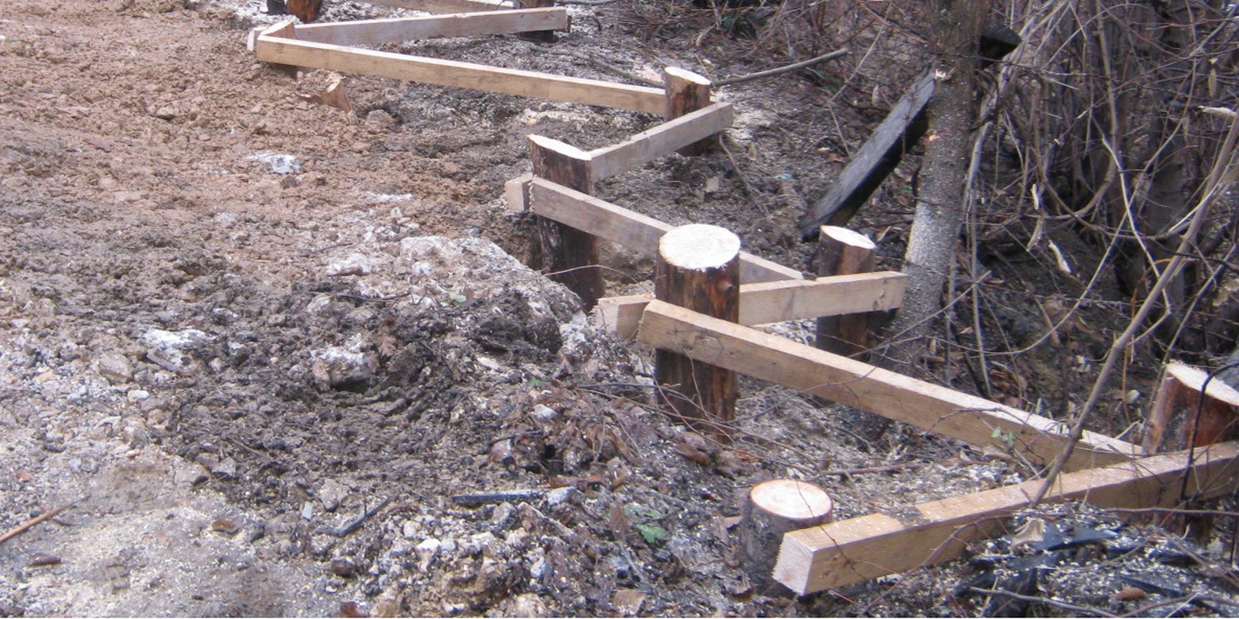
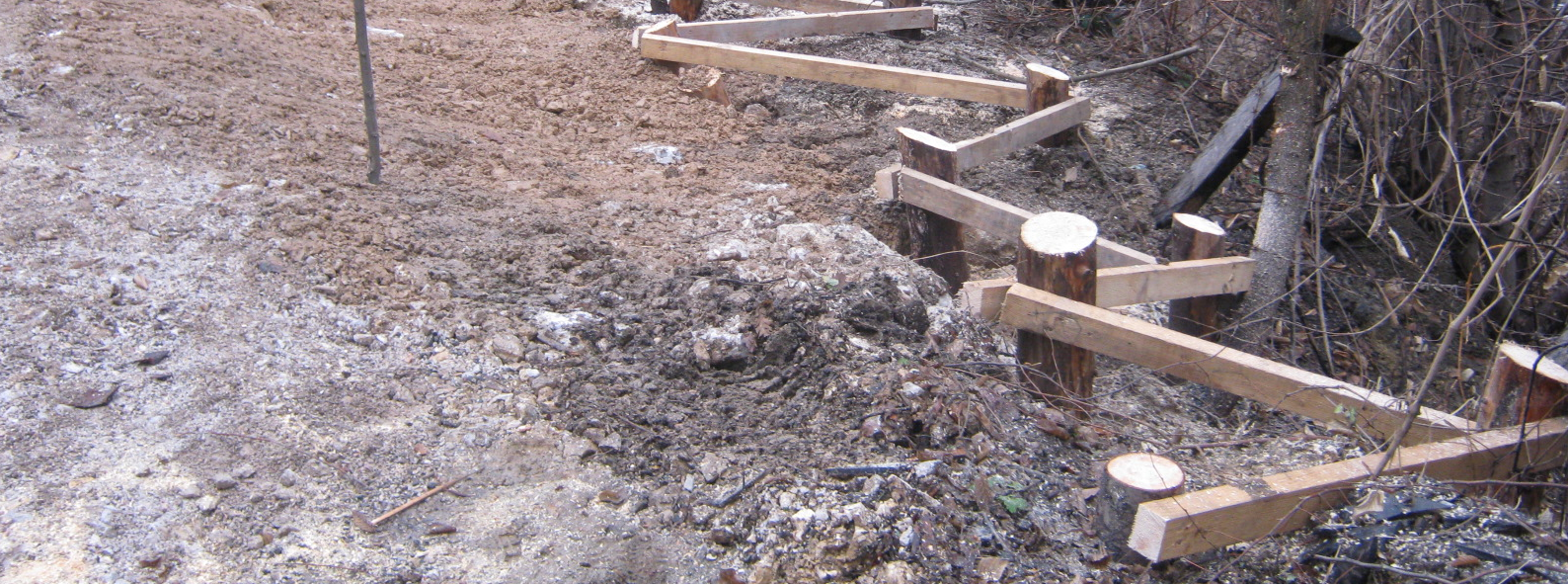
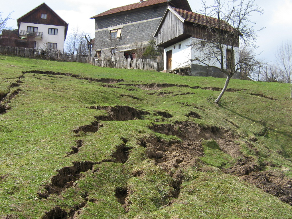
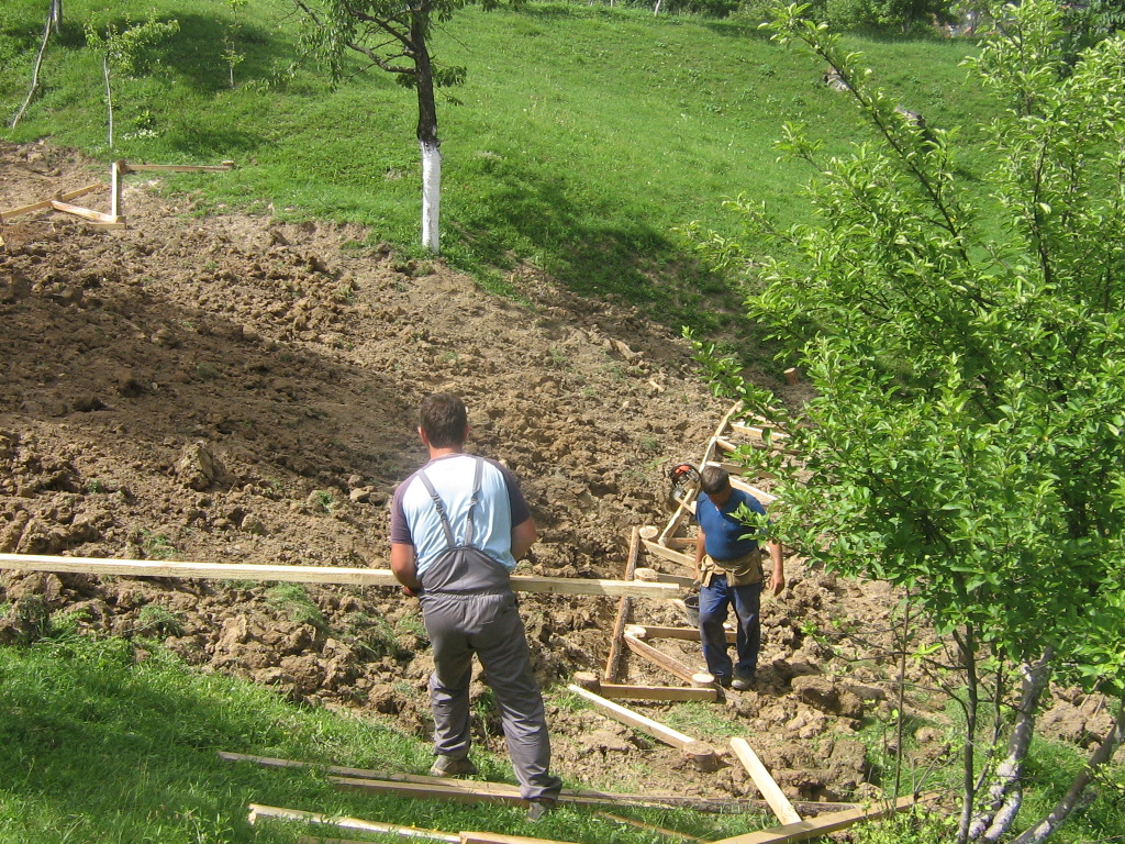
Farmers in northeast parts of Bosnia and Herzegovina traditionally applied the technology to address shallow landslides, surface erosion or loss of top soil due to sheet or interrill erosion. Movements of the upper layers of the soil appears due to unfavorable properties of the soil layers (clays, pseudoclays), set on impermeable geological substrates, all under conditions of intense and long-term rainfall. During the last decades, it has been frequently applied in the area of Kladanj municipality, whose administrative services for agriculture and forestry technically specified and promoted the technology. Landslides are one of the major problems in the hilly areas of Bosnia and Herzegovina, threatening particularly the agricultural lands. The technology is being applied by farmers on their own properties, but it is also part of public interventions, e.g. for the protection of roads or other infrastructure from landslides or in the context of roads recovery programs damaged by landslides. The technology aims to reduce the impact of the shallow (up to 2 - 3 m in depth) landslides of relatively small surface, by preventing further movement of the soil. So far, it is sporadically applied on around 20 – 30 locations in Kladanj Municipality, whose territory is around 355 sq. kilometers.
The technology implies pounding wooden poles in front (below) of the frontline of the landslide, along the contour, perpendicular to the slope. Land users recommend oaken pols due to their durability. The poles are usually 3.5 – 4 m long and 20 – 30 cm in diameter. One pole formation consists of two parallel lines of poles, with 1.5 to 2 m distance from line to line. The poles are positioned in a staggered way that a zigzag is formed. The poles are interconnected with wooden laths. One pole formation is usually enough to address smaller landslides, but in case of larger landslides, two formations are recommended. In the latter case, in combination with a drainage system, stone counterforts are formed in front (above) the poles' formation. See technical drawing for more details.
The primary purpose of the technology is to recover shallow and small landslides on slopping terrains. Stopping the movement of agricultural land after reparation of cracks and land gaps caused by landfall enables re-utilization of the land for either agricultural production or agro-forestry. In the municipality of Kladanj walnuts or other wooden fruit species with strong roots are often planted on recovered landslides.
After a prior assessment of the depth and surface of the landslide, an expert or a technician prepares simple project sketches. The sketches define configuration of pole formations and materials needed for the construction (oak poles, laths). The realization of the technology is not particularly demanding. Nowadays machines are used to pound poles in the ground (mainly by a dredge's spoon).
It is a relatively inexpensive technology which could be financed by even small farmers who can protect or recover their, under Bosnia and Herzegovina conditions, usually small agricultural land parcels.
Although not an integral part of the technology, modification with water drainage from the body of bigger landslide ensures additional, long lasting stability of the terrain. If performed, the drainage is carried out by depositing drainage material (perforated pipes, pebbles, tiny stone fractions) in the lower zone of drainage trenches whose configuration and depth depends on the terrain conditions. Another modification of the technology could include construction of a stone counterfort in front (above) the pole formation. These modifications are briefly presented in the technical specification of the technology, but they were not applied on the site (Borak locality) where activities, establishment and maintenance costs of the technology were observed.
2.3 Photos de la Technologie
Galerie Médias
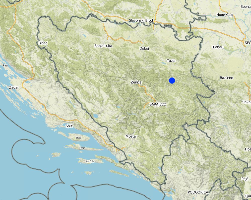
2.5 Pays/ région/ lieux où la Technologie a été appliquée et qui sont couverts par cette évaluation
Pays:
Bosnie-Herzégovine
Région/ Etat/ Province:
Tuzla canton
Autres spécifications du lieu:
Kladanj municipality
Spécifiez la diffusion de la Technologie:
- appliquée en des points spécifiques ou concentrée sur une petite surface
Est-ce que les sites dans lesquels la Technologie est appliquée sont situés dans des zones protégées en permanence?
Non
Map
×2.6 Date de mise en œuvre de la Technologie
Si l'année précise est inconnue, indiquez la date approximative: :
- il y a entre 10-50 ans
2.7 Introduction de la Technologie
Spécifiez comment la Technologie a été introduite: :
- dans le cadre d'un système traditionnel (> 50 ans)
3. Classification de la Technologie de GDT
3.1 Principal(aux) objectif(s) de la Technologie
- réduire, prévenir, restaurer les terres dégradées
- réduire les risques de catastrophes
3.2 Type(s) actuel(s) d'utilisation des terres, là où la Technologie est appliquée
Les divers types d'utilisation des terres au sein du même unité de terrain: :
Non

Terres cultivées
- Cultures annuelles
- Plantations d’arbres ou de buissons
Cultures annuelles - Précisez les cultures:
- céréales - maïs
- céréales - autres
- cultures fourragères - luzerne
- cultures fourragères - autres
- légumes - autres
- Apples, Plums, Pears, Berry fruits
Nombre de période de croissance par an: :
- 1
Est-ce que les cultures intercalaires sont pratiquées?
Oui
Si oui, précisez quelles cultures sont produites en culture intercalaire:
Vegetables in orchards

Pâturages
Pâturage extensif:
- Ranching
Pâturage intensif/ production fourragère :
- Prairies améliorées
Type d'animal:
- bétail - laitier
- bétail - bovins à viande
- ovins
Est-ce que la gestion intégrée cultures-élevage est pratiquée?
Non
Produits et services:
- viande
- lait

Implantations, infrastructures
- Trafic: routes, réseaux ferroviaires
Commentaires:
The technology could be applied on various types of land use. In the northeast region of Bosnia and Herzegovina it is commonly applied on: grazing land, cropland (annual, perennial, trees and shrubs), and mixed land uses. In Kladanj municipality the technology is frequently applied for protection or reconstruction of roads damaged by landslides.
3.3 Est-ce que l’utilisation des terres a changé en raison de la mise en œuvre de la Technologie ?
Est-ce que l’utilisation des terres a changé en raison de la mise en œuvre de la Technologie ?
- Non (Passez à la question 3.4)
Les divers types d'utilisation des terres au sein du même unité de terrain: :
Non
3.4 Approvisionnement en eau
Approvisionnement en eau des terres sur lesquelles est appliquée la Technologie:
- pluvial
3.5 Groupe de GDT auquel appartient la Technologie
- mesures en travers de la pente
- stopping landslides, recovery of landslides
3.6 Mesures de GDT constituant la Technologie

structures physiques
- S3: Fossés étagés, canaux, voies d'eau
- S6: Murs, barrières, palissades, clôtures
3.7 Principaux types de dégradation des terres traités par la Technologie

érosion hydrique des sols
- Wm: mouvements de masse/ glissements de terrain
3.8 Prévention, réduction de la dégradation ou réhabilitation des terres dégradées
Spécifiez l'objectif de la Technologie au regard de la dégradation des terres:
- réduire la dégradation des terres
- restaurer/ réhabiliter des terres sévèrement dégradées
4. Spécifications techniques, activités, intrants et coûts de mise en œuvre
4.1 Dessin technique de la Technologie
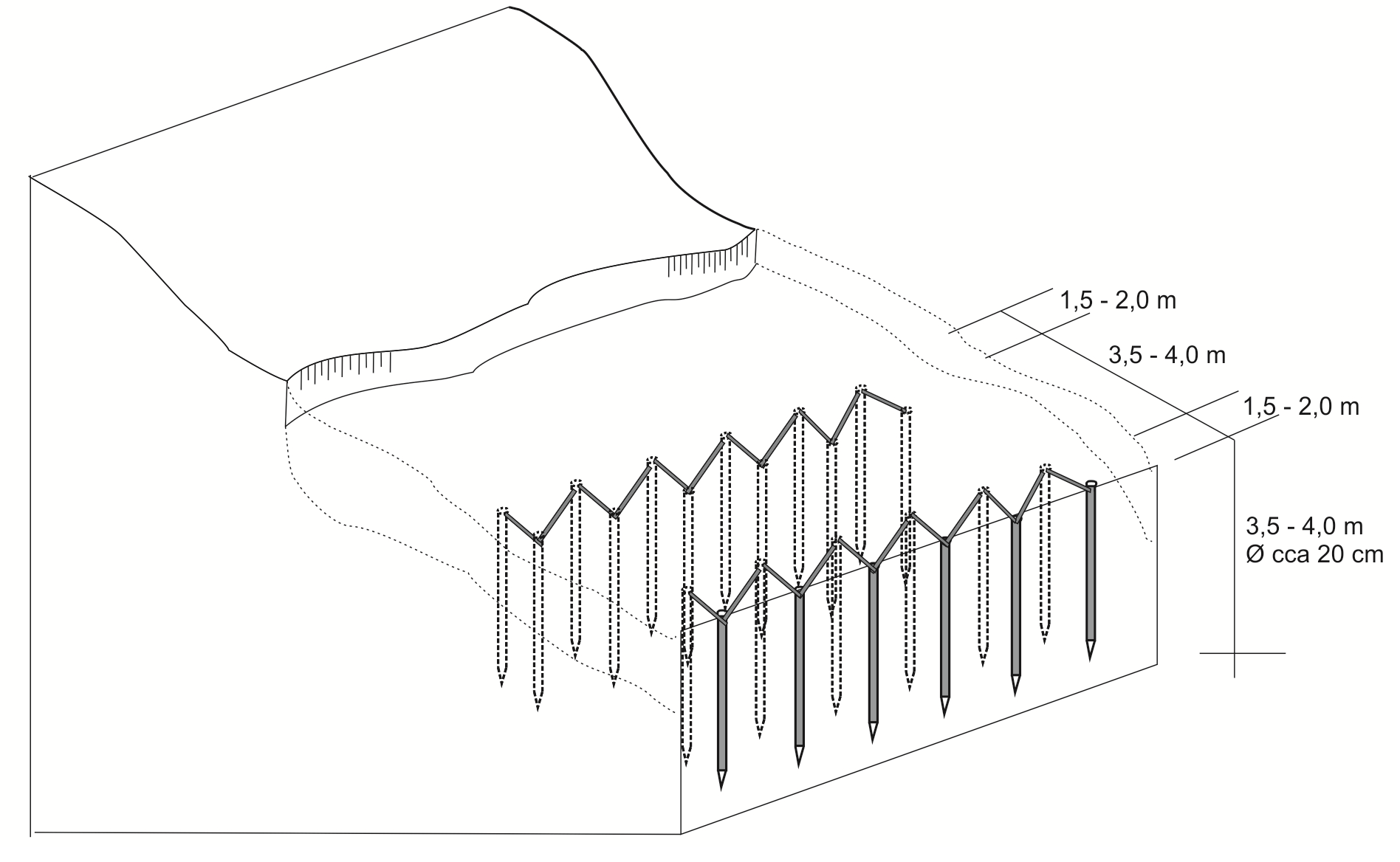
Spécifications techniques (associées au dessin technique):
The sketch depicts the cross-section of the terrain, illustrating the wooden poles’ structures and the technical characteristics of the technology. Two wooden structures are being placed in parallel, at a distance of 3.5-4 m. Each structure is consisted by wooden poles positioned in a zigzag form. The poles are pounded in the ground at a depth of 3.5 m and are connected to each other with wooden laths. The distance between the poles is 1.5-2 m. The number of poles to be used, depends on the size of the area where the intervention is needed. The recommended distance between the two parallel structures is 3 – 4 m, depending on the characteristics of the terrain.
The implementation of the technology does not bring any change on the slope and could be applied on various slopes. The technology is mostly applied on agricultural or infrastructural land, i.e. on slopes not above 30%.
Auteur:
Muhamed Bajrić, Milenko Blesić
Date:
20/10/2018
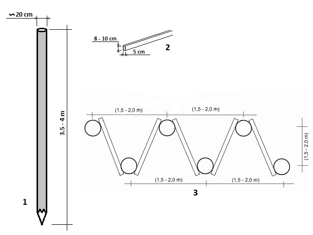
Spécifications techniques (associées au dessin technique):
Drawing 1 shows the recommended dimensions of the poles.Drawing 2 illustrates the technical characteristics of the laths (2) which connect the poles. Drawing 3 shows the top view of the overall structure with the required dimensions.
Auteur:
Milenko Blesić, Muhamed Bajrić
Date:
20/10/2018
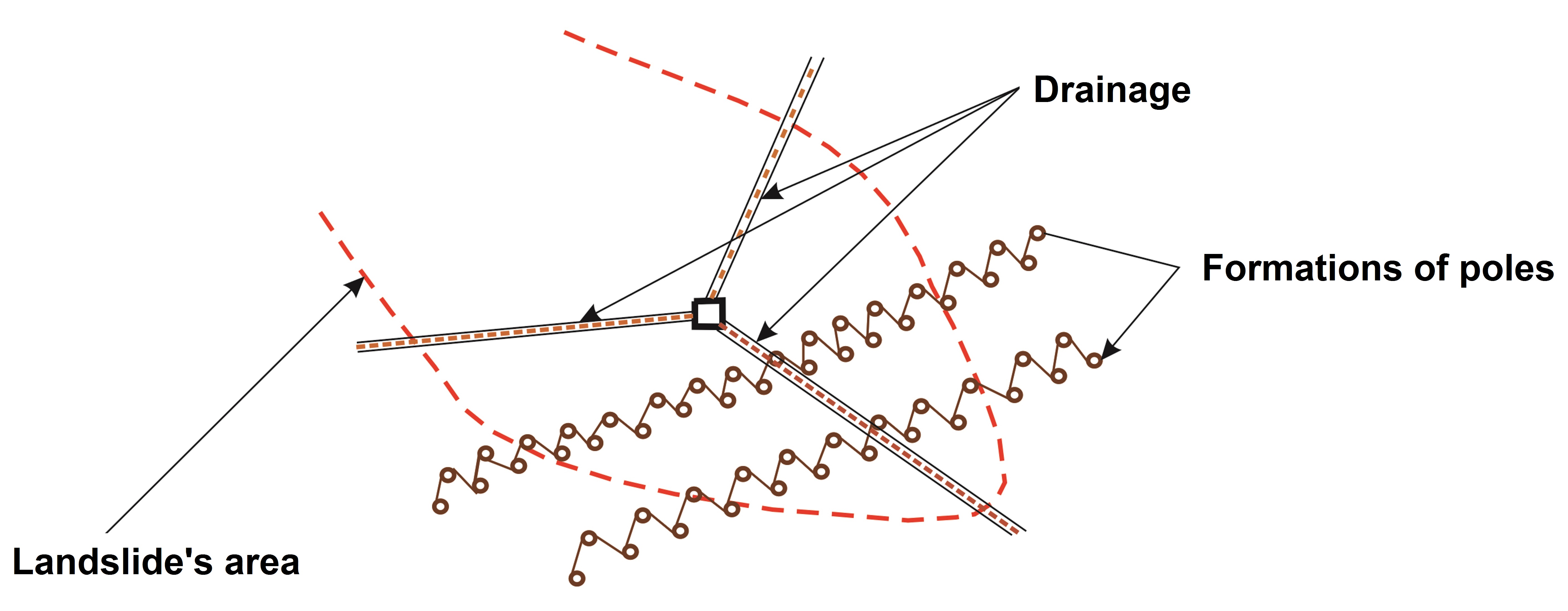
Spécifications techniques (associées au dessin technique):
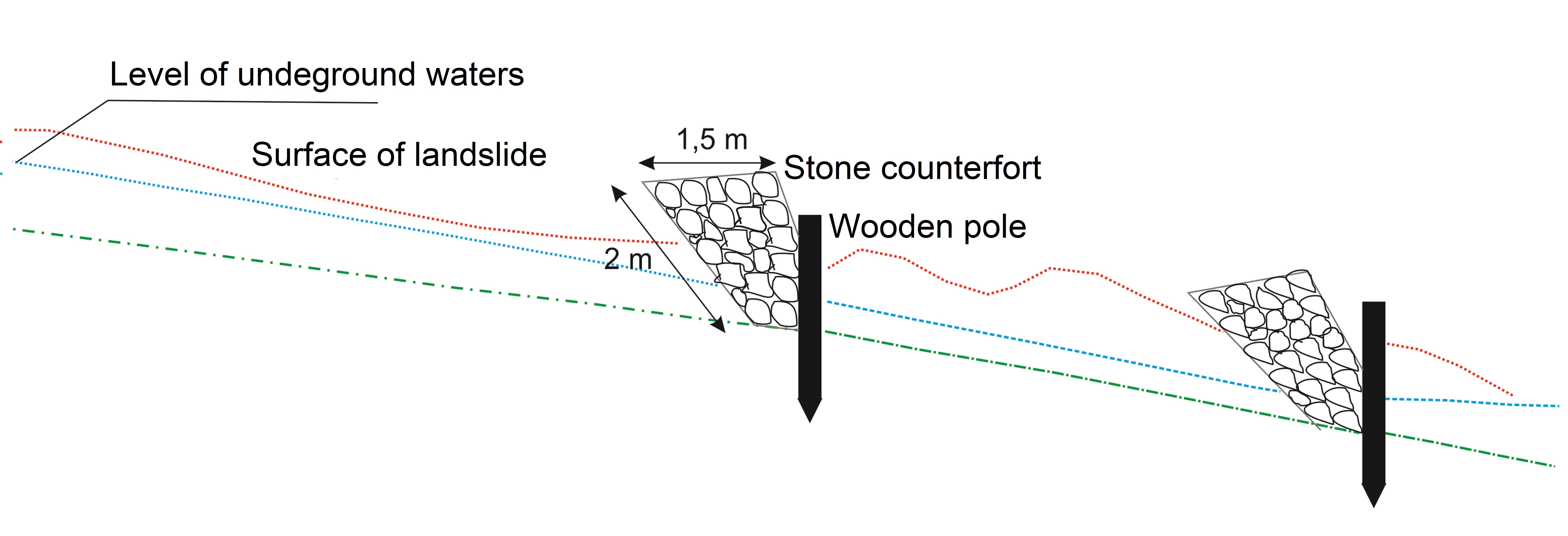
Modification (improvement) of the technology with a drainage system. The modification (drainage) was not applied on the site where the technology was observed.
Auteur:
Muhamed Bajrić
Date:
10/11/2018
Spécifications techniques (associées au dessin technique):
Modification (improvement) of the technology by construction of the stone counterforts just above the line of poles. The modification (stone counterforts) was not applied on the site where the technology was observed.
Auteur:
Muhamed Bajrić
Date:
10/11/2018
4.2 Informations générales sur le calcul des intrants et des coûts
Spécifiez la manière dont les coûts et les intrants ont été calculés:
- par entité de la Technologie
Précisez l'unité:
Landslide on Borak locality - Kladanj municipalitay
Précisez les dimensions de l'unité de terrain (le cas échéant):
0,35 ha
Indiquez la monnaie utilisée pour le calcul des coûts:
- dollars américains
Indiquez le coût salarial moyen de la main d'œuvre par jour:
29.24 USD
4.3 Activités de mise en place/ d'établissement
| Activité | Calendrier des activités (saisonnier) | |
|---|---|---|
| 1. | Expert's characterization of landslide | Any time |
| 2. | Designing the structure and identifying the materials | Any time |
| 3. | Purchase and transport of materials (poles, laths) | Any time |
| 4. | Pounding poles in the ground | Spring - autumn |
| 5. | Connection of poles' heads (above ground parts) with laths | Spring - autumn |
| 6. | Machine leveling of the terrain | Spring - autumn |
| 7. | Planting of walnut seedlings | Autumn |
Commentaires:
Establishment activities are presented in accordance withe the activities on one specific (Borak) locality. The surface of landslide on this locality was around 0,35 ha, and after its stopping with the formation of wooden poles, its full recovery was done by leveling of the terrain and planting of 300 walnut seedlings (further walnut orchard). The list of final recovery activities could be different on other localities and it depends of landowners' intentions and financial possibilities.
4.4 Coûts et intrants nécessaires à la mise en place
| Spécifiez les intrants | Unité | Quantité | Coûts par unité | Coût total par intrant | % du coût supporté par les exploitants des terres | |
|---|---|---|---|---|---|---|
| Main d'œuvre | Expert's characterization of landslide, designing of construction, specification of materials | Working day | 2,0 | 100,0 | 200,0 | 100,0 |
| Main d'œuvre | Pounding the poles into the ground | Working day | 10,0 | 29,24 | 292,4 | 100,0 |
| Main d'œuvre | Connecting poles with lathes | Working day | 1,0 | 29,24 | 29,24 | 100,0 |
| Main d'œuvre | Planting of walnut seedlings | Working day | 10,0 | 29,24 | 292,4 | 100,0 |
| Equipements | Heavy machinery (dredge) work on pounding poles into the ground (hired) | Hour | 16,0 | 46,78 | 748,48 | 30,0 |
| Equipements | Heavy machinery (dredge) work on leveling of terrain | Hour | 4,0 | 46,78 | 187,12 | 30,0 |
| Matériel végétal | Walnut seedlings | Piece | 300,0 | 2,92 | 876,0 | 30,0 |
| Matériaux de construction | Wooden (oak) poles | Piece | 100,0 | 17,5 | 1750,0 | 30,0 |
| Matériaux de construction | Wooden connecting laths | m | 200,0 | 0,5 | 100,0 | 30,0 |
| Matériaux de construction | Other auxiliary materials (nails, wire, etc.) | Lump sum | 1,0 | 12,0 | 12,0 | 100,0 |
| Coût total de mise en place de la Technologie | 4487,64 | |||||
| Coût total de mise en place de la Technologie en dollars américains (USD) | 4487,64 | |||||
Si le coût n'est pas pris en charge à 100% par l'exploitant des terres, indiquez qui a financé le coût restant:
So far, introduction of the technology in Kladanj municipality is supported from the municipality's budget (contribution in purchase of materials and hiring of heavy machinery).
Commentaires:
The presented activities and costs are related to the landslide (0,35 ha) on Borak (Kladanj municipality) locality. On this particular site, the technology is applied without drainage system and stone counterforts next to wooden pole lines. Though they are not linearly connected, costs on other sites may be smaller or higher, depending on the size of landslides and concrete conditions on the ground.
4.5 Activités d'entretien/ récurrentes
Commentaires:
After establishment, the technology does not need any particular maintenance activities.
4.6 Coûts et intrants nécessaires aux activités d'entretien/ récurrentes (par an)
Commentaires:
Due to the fact that after establishment the technology does not need any major maintenance activities, there are not any significant costs for maintenance. The maintenance is limited to annual checking of joints between lathes and poles and necessary minor interventions (replacement of possibly damaged lathes, re-connection of laths).
4.7 Facteurs les plus importants affectant les coûts
Décrivez les facteurs les plus importants affectant les coûts :
Prices of the construction materials (poles, laths).
Hiring costs of heavy machinery (dredge).
5. Environnement naturel et humain
5.1 Climat
Précipitations annuelles
- < 250 mm
- 251-500 mm
- 501-750 mm
- 751-1000 mm
- 1001-1500 mm
- 1501-2000 mm
- 2001-3000 mm
- 3001-4000 mm
- > 4000 mm
Spécifiez la pluviométrie moyenne annuelle (si connue), en mm:
894,00
Spécifications/ commentaires sur les précipitations:
The highest precipitations appear during spring and early summer, (June 111 L/m2; February 55 L/m2). Heavy downpours during summer is one of the climatic features of this area.
Indiquez le nom de la station météorologique de référence considérée:
Tuzla
Zone agro-climatique
- subhumide
5.2 Topographie
Pentes moyennes:
- plat (0-2 %)
- faible (3-5%)
- modéré (6-10%)
- onduleux (11-15%)
- vallonné (16-30%)
- raide (31-60%)
- très raide (>60%)
Reliefs:
- plateaux/ plaines
- crêtes
- flancs/ pentes de montagne
- flancs/ pentes de colline
- piémonts/ glacis (bas de pente)
- fonds de vallée/bas-fonds
Zones altitudinales:
- 0-100 m
- 101-500 m
- 501-1000 m
- 1001-1500 m
- 1501-2000 m
- 2001-2500 m
- 2501-3000 m
- 3001-4000 m
- > 4000 m
Indiquez si la Technologie est spécifiquement appliquée dans des:
- non pertinent
5.3 Sols
Profondeur moyenne du sol:
- très superficiel (0-20 cm)
- superficiel (21-50 cm)
- modérément profond (51-80 cm)
- profond (81-120 cm)
- très profond (>120 cm)
Texture du sol (de la couche arable):
- moyen (limoneux)
Texture du sol (> 20 cm sous la surface):
- fin/ lourd (argile)
Matière organique de la couche arable:
- moyen (1-3%)
5.4 Disponibilité et qualité de l'eau
Profondeur estimée de l’eau dans le sol:
en surface
Disponibilité de l’eau de surface:
moyenne
Qualité de l’eau (non traitée):
uniquement pour usage agricole (irrigation)
La qualité de l'eau fait référence à:
eaux de surface
La salinité de l'eau est-elle un problème? :
Non
La zone est-elle inondée?
Oui
Régularité:
épisodiquement
5.5 Biodiversité
Diversité des espèces:
- moyenne
Diversité des habitats:
- moyenne
5.6 Caractéristiques des exploitants des terres appliquant la Technologie
Sédentaire ou nomade:
- Sédentaire
Orientation du système de production:
- exploitation mixte (de subsistance/ commerciale)
Revenus hors exploitation:
- > 50% de tous les revenus
Niveau relatif de richesse:
- moyen
Individus ou groupes:
- individu/ ménage
Niveau de mécanisation:
- travail manuel
- mécanisé/ motorisé
Genre:
- hommes
Age des exploitants des terres:
- personnes d'âge moyen
5.7 Superficie moyenne des terres utilisées par les exploitants des terres appliquant la Technologie
- < 0,5 ha
- 0,5-1 ha
- 1-2 ha
- 2-5 ha
- 5-15 ha
- 15-50 ha
- 50-100 ha
- 100-500 ha
- 500-1 000 ha
- 1 000-10 000 ha
- > 10 000 ha
Cette superficie est-elle considérée comme de petite, moyenne ou grande dimension (en se référant au contexte local)?
- moyenne dimension
5.8 Propriété foncière, droits d’utilisation des terres et de l'eau
Propriété foncière:
- individu, avec titre de propriété
Droits d’utilisation des terres:
- individuel
Droits d’utilisation de l’eau:
- accès libre (non organisé)
Est-ce que les droits d'utilisation des terres sont fondés sur un système juridique traditionnel?
Oui
5.9 Accès aux services et aux infrastructures
santé:
- pauvre
- modéré
- bonne
éducation:
- pauvre
- modéré
- bonne
assistance technique:
- pauvre
- modéré
- bonne
emploi (par ex. hors exploitation):
- pauvre
- modéré
- bonne
marchés:
- pauvre
- modéré
- bonne
énergie:
- pauvre
- modéré
- bonne
routes et transports:
- pauvre
- modéré
- bonne
eau potable et assainissement:
- pauvre
- modéré
- bonne
services financiers:
- pauvre
- modéré
- bonne
6. Impacts et conclusions
6.1 Impacts sur site que la Technologie a montrés
Impacts socio-économiques
Revenus et coûts
revenus agricoles
diversité des sources de revenus
Impacts écologiques
Sols
perte en sol
Réduction des risques de catastrophe et des risques climatiques
glissements de terrains/coulées de débris
6.2 Impacts hors site que la Technologie a montrés
inondations en aval
envasement en aval
dommages sur les champs voisins
dommages sur les infrastructures publiques/ privées
6.3 Exposition et sensibilité de la Technologie aux changements progressifs et aux évènements extrêmes/catastrophes liés au climat (telles que perçues par les exploitants des terres)
Changements climatiques progressifs
Changements climatiques progressifs
| Saison | Augmentation ou diminution | Comment la Technologie fait-elle face à cela? | |
|---|---|---|---|
| températures annuelles | augmente | bien | |
| températures saisonnières | été | augmente | bien |
| précipitations saisonnières | été | décroît | bien |
Extrêmes climatiques (catastrophes)
Catastrophes météorologiques
| Comment la Technologie fait-elle face à cela? | |
|---|---|
| pluie torrentielle locale | bien |
Catastrophes hydrologiques
| Comment la Technologie fait-elle face à cela? | |
|---|---|
| crue éclair | très bien |
6.4 Analyse coûts-bénéfices
Quels sont les bénéfices comparativement aux coûts de mise en place (du point de vue des exploitants des terres)?
Rentabilité à court terme:
légèrement négative
Rentabilité à long terme:
positive
Quels sont les bénéfices comparativement aux coûts d'entretien récurrents (du point de vue des exploitants des terres)?
Rentabilité à court terme:
positive
Rentabilité à long terme:
très positive
6.5 Adoption de la Technologie
- 1-10%
Si disponible, quantifiez (nombre de ménages et/ou superficie couverte):
According to information from Kladanj municipality administration, on the municipality territory there are around 30 localities with the applied technology.
De tous ceux qui ont adopté la Technologie, combien d'entre eux l'ont fait spontanément, à savoir sans recevoir aucune incitation matérielle, ou aucune rémunération? :
- 0-10%
Commentaires:
Most of the interventions on private properties were partly supported by specific municipal/cantonal programs for recovery of lands, damaged by heavy rains, flash floods and landslides. All interventions on infrastructure (mainly roads) were fully supported by municipal/cantonal budgets.
6.6 Adaptation
La Technologie a-t-elle été récemment modifiée pour s'adapter à l'évolution des conditions?
Oui
autre (précisez):
Improvemnts of the technology effects and durability
Spécifiez l'adaptation de la Technologie (conception, matériaux/ espèces, etc.):
The original technology (wooden poles barriers) has been recently modified by parallel installment of drainage of landslide, and most recently by stone enforcement just above the line of wooden poles.
6.7 Points forts/ avantages/ possibilités de la Technologie
| Points forts/ avantages/ possibilités du point de vue de l'exploitant des terres |
|---|
| Relatively affordable way to stop and recover landslides on agricultural land |
| Wide availability of construction material (wood) in the region |
| Points forts/ avantages/ possibilités du point de vue du compilateur ou d'une autre personne ressource clé |
|---|
| Costly effective way to recover agricultural land on small private parcels (usual in Bosnia and Herzegovina) endangered by landslides |
| The technology keeps land from further degradation or possible loss of soil and allows continuation of its current or different functional use |
6.8 Faiblesses/ inconvénients/ risques de la Technologie et moyens de les surmonter
| Faiblesses/ inconvénients/ risques du point de vue de l’exploitant des terres | Comment peuvent-ils être surmontés? |
|---|---|
| It is not always easy to find/hire heavy mechanization for pounding of poles into the ground | Organization of farmers who want to introduce the technology and request for municipality support in hiring heavy machinery |
| Faiblesses/ inconvénients/ risques du point de vue du compilateur ou d'une autre personne ressource clé | Comment peuvent-ils être surmontés? |
|---|---|
| Limited durability of the wooden poles. | |
| The technology itself (i.e. without extensive drainage) is not efficient in stopping and recovering larger and deep landslides | Added investment in properly projected and implemented drainage system |
7. Références et liens
7.1 Méthodes/ sources d'information
- visites de terrain, enquêtes sur le terrain
Field surveys from May to December 2018, valuable information from Ms Hajda Hajdarević, Kladanj municipality's office for agriculture.
- interviews/entretiens avec les exploitants des terres
During filed surveys five land users who applied the technology were interviewed.
- interviews/ entretiens avec les spécialistes/ experts de GDT
Besides field surveys, precious information regarding the landslide issues and possible technology effects were provided by professors Hamid Čustović and Muhamed Bajrić (University of Sarajevo).
Commentaires:
Field data compilation was done through six field surveys performed between May and December 2018.
Liens et modules
Développer tout Réduire toutLiens
Aucun lien
Modules
Aucun module trouvé