
Community members planting willow tripods in front of new gabions to prevent riverbank erosion (Nodir Muhidinov)
Villages and associated productive lands like orchards, gardens and arable fields in the lower parts of the northern main slope of the Turkestan mountain range are typically located in the valleys of rivers and streams. Water discharge in these rivers and streams is seasonally highly variable. During the wet season water flow is very high, while during the dry summer and fall months almost no water is visible at the surface and the limited discharge takes place in the gravel of the riverbed. After rainfall and during snowmelt extreme flow events happen with discharges several times exceeding the average of the wet season. Flashfloods with high speed and energy typically cause the transportation of large amounts of debris. These debris flows can be much more destructive than ordinary high water events. The resulting riverbank erosion is in some extent a natural element of the morphological dynamic of rivers and streams.
Land-use related factors have increased the vulnerability of communities to these flashfloods and debris flows as well as their destructiveness. Population growth, the expansion of settlements and the reclamation of more lands for irrigated orchards, gardens and arable fields have brought more people and values into potentially risky areas. The degradation of the vegetation in upper catchments has contributed to reduced infiltration of water and high and fast surface runoff. The riparian forests and woodlands which in some extent slow down flashfloods and keep sediment have been largely destroyed by clearing, livestock grazing and by the increasing intensity of flashflood events.
These problems are increasingly exacerbated by the impact of climate change. The already visible trends and predictions show higher levels of aridity, higher temperatures during the vegetation season, reduced overall precipitation in catchment areas – all affecting the retention potential of upper catchment areas – and more irregular rainfall patterns, reduced snow packs and accelerated snow melt as well as the loss of glaciers as buffers of water flow. These factors all contribute to a higher frequency and intensity of flashflood and debris flows.
These events threaten settlements, infrastructure and human lives, but they also pose substantial risks to the stability and functioning of irrigation canals, cause irreversibly losses of productive lands and thus threaten livelihoods of farmers and food security.
The approach brought together the Committee of Emergency Situations, affected local people and the administrative communities, the mahalla committees, which represent the inhabitants of one village or a section of a larger village. These institutions are called communal self-governance structures, but are subordinated to the government as they are reporting to the sub-district or jamoat. Assisted by experts provided by the project, the situation was jointly analyzed; risks identified and integrated intervention planned. Typically the interventions consisted of a combination of “grey” (i.e. constructive structures) and “green” (i.e. protective vegetation) measures. Most of the upper catchment areas belong to different communities, often to different districts and substantial parts are located in neighboring Kyrgyzstan. Therefore addressing the degradation of these areas and a reduction of disaster risk through integrated watershed management in the entire catchments was rarely possible.
The project assisted with technical planning, construction supervision, purchase and transportation of construction materials. The communities would contribute about 30% of the overall costs, mainly in form of voluntary communal work, the so called hashar, as well as in form of locally available construction materials. The community is also in charge of future operation and maintenance of the riverbank protection structures.

ទីតាំង: Spitamen district, Devashtich district, Sughd region, ប្រទេសតាហ្ស៊ីគីស្ថាន
កាលបរិច្ឆេទចាប់ផ្តើម: 2014
ឆ្នាំបញ្ចប់: មិនមាន
ប្រភេទនៃវិធីសាស្ត្រផ្សព្វផ្សាយ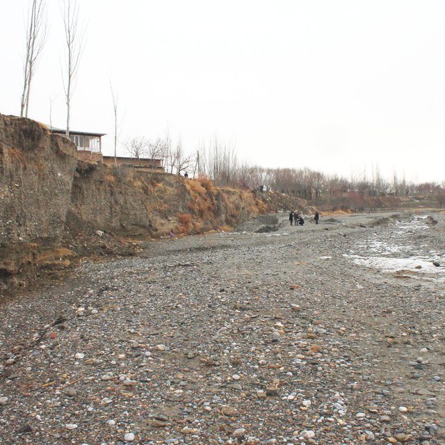

| តើមានភាគីពាក់ព័ន្ធ/ភ្នាក់ងារអនុវត្តន៍ណាខ្លះដែលបានចូលរួមក្នុងវិធីសាស្ត្រផ្សព្វផ្សាយ? | សូមបញ្ជាក់ភាគីពាក់ព័ន្ធ | សូមពណ៌នាតួនាទីរបស់ភាគីពាក់ព័ន្ធ |
| អ្នកប្រើប្រាស់ដីក្នុងតំបន់/សហគមន៍ | Inhabitants of village | Participation in identification of risk sites; Volunteer work |
| អ្នកឯកទេសគ្រប់គ្រងដីប្រកបដោយចីរភាព/ទីប្រឹក្សាបច្ចេកទេសកសិកម្ម | Engineers provided by GIZ | Identification of risk sites; Design, planning and supervision of interventions. |
| រដ្ឋាភិបាលថ្នាក់មូលដ្ឋាន | District branches of Committee for Emergency Situations | Participation in identification of risk sites; Agreement of plans for interventions |
ការសម្រេចចិត្តត្រូវបានធ្វើដោយ
ការសម្រេចចិត្តត្រូវបានធ្វើដោយផ្អែកលើ៖
កំលាំងពលកម្មដោយអ្នកប្រើប្រាស់ដីគឺ
People mobilized to address common issues.
Grey and geeen measures for prevention of riverbank erosion
Combination of financial and technical support by GIZ and contributions in form of work and locally available materials by community members.
Community members capable of replicating the technologies.
Committee of Emergency Situations capable of replicating the technologies.
Involvement of young people in joint work
Reduced risk of destruction of irrigation infrastructure and of loss of productive lands.
Reduced risk of destructive impacts of flashfloods and debris flows, which due to climate change are increasing in frequency and intensity.


