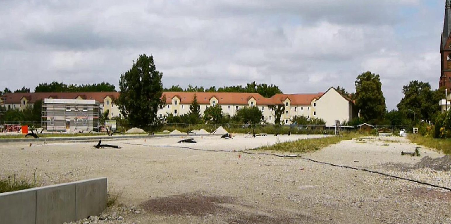
urban brownsfield in Halle (XXX, University Harz (Wernigerode))

High-quality inner urban development (ប្រទេសអាល្លឺម៉ង់)

Qualitätsvolle Innenentwicklung (German)

ការពណ៌នា

A scenario simulation of land use change where high-quality inner urban development is promoted, including the rehabilitation of brownfields, reuse of vacant lots, use of gaps between buildings and the improvement of existing structures.

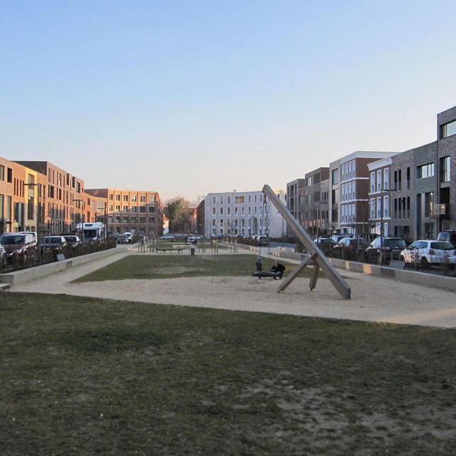
The best means of reducing land loss by settlement and infrastructure development is through fulfilling inner urban development potential. This “compact settlement development” makes the most efficient use of space. Simultaneously it contributes to the reduction of greenhouse gas emissions by the maintenance of farmland or forest areas on the outskirts of urban areas. One example is the rehabilitation and utilization of “brownfields”, including previous industrial areas. Another example is redevelopment of transportation infrastructure within settlements or on the urban fringe. However, the revitalization and utilization of brownfields is often expensive. Other aspects of inner urban development are the reuse of vacant lots, the use of spaces between buildings and the improvement of existing building structures by adding extra floors.

Purpose of the Technology: Through these developments, the rate of daily land consumption by settlement and transportation can be reduced. In Germany, such land loss reached 73 ha/day in 2010. According to a survey commissioned by the Federal Office for Building and Regional Planning, 20% of existing brownfields and vacant lots can be brought into use in the short term and another 50% of the total in the long term: 30% cannot be developed for various reasons including disputed tenure. The ambitious aim of the sustainability strategy of the German federal government is to reduce today’s daily land consumption for settlement and transport from the current 73 ha/day to 30 ha/day by 2020. However this appears unrealistic: nevertheless with high-quality inner urban development technology, this could be achieved by 2030. If the technology is planned and implemented through scenario simulation of sectoral land use changes in Germany (agriculture, forest and settlements), then calculations show that the daily land loss by settlement and transport could be reduced from 45 ha/day in a “business as usual” scenario (with some improvements assumed) to 30 ha/per day in 2030 by using high-quality inner urban development measures.

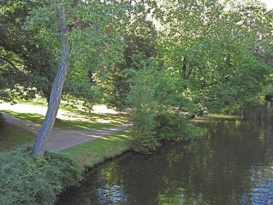
Establishment / maintenance activities and inputs: During re-densification of urban areas sufficient green spaces must be protected to address climate change considerations such as higher temperatures and more runoff. High urban densities lead to an increase in the “heat island effect” (a combination of extensive urban/ suburban landscapes with reduced air circulation, little cloud cover and long periods of high temperature). Thus, the rehabilitation of brownfields has to go along with the transformation of impervious surfaces into permeable ones, and planning of corridors for air exchange by “green and blue climate corridors” (public parks, ponds and rivers). There are several initiatives to establish high quality inner urban development in Germany. These include: 1) “Inner before external” urban development within the Federal Building Law; 2) Many communities operating a brownfields and vacant lots cadastre; 3) General management of urban areas. Nevertheless, the reuse of inner city brownfields often requires considerable and costly remediation of contaminated sites. Due to the ownership issues of vacant lots, many are not easily accessible through municipalities, and this complicates their development. In other cases, available construction areas or buildings are not appropriate to the needs of investors.

ទីតាំង

ទីតាំង: Rheinisch-Bergischer Kreis and Rhein-Sieg-Kreis, Germany, North Rhine-Westphalia, ប្រទេសអាល្លឺម៉ង់

ចំនួនទីកន្លែងបច្ចេកទេស ដែលវិភាគ:

ចំណុចយោងភូមិសាស្ត្រនៃទីតាំងជ្រើសរើស
  • មិនមាន

ការសាយភាយនៃបច្ចេកទេស:

តើស្ថិតក្នុងតំបន់ការពារអចិន្ត្រៃយ៍?:

កាលបរិច្ឆេទនៃការអនុវត្ត: តិចជាង 10ឆ្នាំមុន (ថ្មី)

ប្រភេទនៃការណែនាំឱ្យអនុវត្តន៍៖
Building area St. Leonhardsgarten situated at the former tram depot Altewiekring in Brunswiek (Johanna Fick)
Building area St. Leonhardsgarten situated at the former tram depot Altewiekring in Brunswiek (Johanna Fick (Thünen-Institut für Ländliche Räume, Bundesallee 50, 38116 Braunschweig))

ចំណាត់ថ្នាក់នៃបច្ចេកទេស

គោលបំណងចម្បងៗ
  • ធ្វើឱ្យប្រសើរឡើងនូវផលិតកម្ម
  • កាត់បន្ថយ, បង្ការ, ស្តារឡើងវិញនូវការធ្លាក់ចុះគុណភាពដី
  • អភិរក្សប្រព័ន្ធអេកូឡូស៊ី
  • ការពារតំបន់ទីជម្រាល/តំបន់ខ្សែទឹកខាងក្រោមបញ្ចូលជាមួយបច្ចេកទេសផ្សេងទៀត
  • អភិរក្ស/ធ្វើឱ្យប្រសើរឡើងជីវចម្រុះ
  • កាត់បន្ថយហានិភ័យនៃគ្រោះមហន្តរាយ
  • បន្ស៊ាំទៅនឹងការប្រែប្រួលអាកាសធាតុ/គ្រោះមហន្តរាយ និងផលប៉ះពាល់របស់វា
  • កាត់បន្ថយការប្រែប្រួលអាកាសធាតុ និងផលប៉ះពាល់របស់វា
  • បង្កើតផលប្រយោជន៍សេដ្ឋកិច្ច
  • បង្កើតផលប្រយោជន៍សង្គម
ការប្រើប្រាស់ដី

  • លំនៅដ្ឋាន ហេដ្ឋារចនាសម្ព័ន្ធ -
ការផ្គត់ផ្គង់ទឹក
  • ទឹកភ្លៀង
  • ទឹកភ្លៀង និងប្រព័ន្ធស្រោចស្រព
  • ប្រព័ន្ធស្រោចស្រពទាំងស្រុង

គោលបំណងទាក់ទងនឹងការធ្លាក់ចុះគុណភាពដី
  • ការការពារការធ្លាក់ចុះគុណភាពដី
  • ការកាត់បន្ថយការធ្លាក់ចុះគុណភាពដី
  • ការជួសជុល/ ស្តារឡើងវិញនៃឱនភាពដីធ្ងន់ធ្ងរ
  • ការបន្ស៊ាំទៅនឹងការធ្លាក់ចុះគុណភាពដី
  • ដែលមិនអាចអនុវត្តបាន
ប្រភេទនៃការធ្លាក់ចុះគុណភាពដីដែលបានដោះស្រាយ
  • ការបាត់បង់រូបសាស្ត្រនៃដី - Pk: ការបិទរន្ធដី, Pu: បាត់បង់នូវផលិតភាពជីវៈដោយសារសកម្មភាពផ្សេងៗ
  • ការធ្លាក់ចុះជីវសាស្ត្រនៃដី - Bh: ការបាត់បង់ទីជំរក, Bq: ការថយចុះនូវជីវម៉ាស/​ បរិមាណ
ក្រុម SLM
  • Compact settlement development
វិធានការ SLM
  • វិធានការគ្រប់គ្រង - M1: ការផ្លាស់ប្តូរប្រភេទដីប្រើប្រាស់, M2: ការផ្លាស់ប្តូរការគ្រប់គ្រង/ កម្រិតអាំងតង់ស៊ីតេ

គំនូរបច្ចេកទេស

លក្ខណៈបច្ចេកទេស
Green and blue structure like parks, trees, alleys (green) and water areas like rivers, canals, ponds and lakes (blue) are relevant issues especially with respect to the climate adaptation

Technical knowledge required for scientific staff: high

Main technical functions: spatial arrangement and diversification of land use, reduces the loss of agricultural land and forests

Change of land use type: Brownfields are converted to settlement area. Agricultural area is conserved.

Change of land use practices / intensity level: Settlement density may increase with inner urban development.
Author: Johanna Fick

ការបង្កើតនិងការថែទាំ៖​ សកម្មភាព ធាតុចូល និងថ្លៃដើម

ការគណនាធាតុចូល​ និងថ្លៃដើម
  • ថ្លៃដើមត្រូវបានគណនា៖
  • រូបិយប័ណ្ណសម្រាប់ការគណនាថ្លៃដើម៖ មិនមាន
  • អត្រាប្តូរប្រាក់ (ទៅជាដុល្លារអាមេរិក)៖ 1 USD = មិនមាន
  • ថ្លៃឈ្នួលជាមធ្យមក្នុង ១ ថ្ងៃ៖ មិនមាន
កត្តាសំខាន់បំផុតដែលមានឥទ្ធិពលលើថ្លៃដើម
Measures can be very different in terms of inputs and costs, and depend on the specific situation eg contaminated area of a former petrol station can have very high rehabilitation costs due to the need to detoxify the soil before new use. However other measures cost (effectively) no money at all eg legislation governing the reduction of the distance permitted between two new buildings by the local authorities.
សកម្មភាពបង្កើតបច្ចេកទេស
  1. Data collection (ពេលវេលា/ ភាពញឹកញាប់: Half a year)
  2. Implementation into the model and model calibration (ពេលវេលា/ ភាពញឹកញាប់: Half a year)
  3. Model runs (ពេលវេលា/ ភាពញឹកញាប់: one month)
  4. Evaluation (ពេលវេលា/ ភាពញឹកញាប់: one month)
  5. Scenario development (ពេលវេលា/ ភាពញឹកញាប់: None)
សកម្មភាពថែទាំ
n.a.

បរិស្ថានធម្មជាតិ

បរិមាណទឹកភ្លៀងជាមធ្យមប្រចាំឆ្នាំ
  • < 250 មម
  • 251-500 មម
  • 501-750 មម
  • 751-1,000 មម
  • 1,001-1,500 មម
  • 1,501-2,000 មម
  • 2,001-3,000 មម
  • 3,001-4,000 មម
  • > 4,000 មម
តំបន់កសិអាកាសធាតុ
  • សើម
  • មានភ្លៀងមធ្យម
  • មានភ្លៀងតិចតួច
  • ស្ងួត
លក្ខណៈសម្គាល់នៃអាកាសធាតុ
Annual rainfall: 250-500 mm, 500-750 mm, 750-1000 mm, 1000-1500 mm
Thermal climate class: temperate
ជម្រាល
  • រាបស្មើ (0-2%)
  • ជម្រាលតិចតួច (3-5%)
  • មធ្យម (6-10%)
  • ជម្រាលខ្ពស់បន្តិច (11-15%)
  • ទីទួល (16-30%)
  • ទីទួលចោត (31-60%)
  • ទីទួលចោតខ្លាំង (>60%)
ទម្រង់ដី
  • ខ្ពង់រាប
  • កំពូលភ្នំ
  • ជម្រាលភ្នំ
  • ជម្រាលទួល
  • ជម្រាលជើងភ្នំ
  • បាតជ្រលងភ្នំ
រយៈកម្ពស់ធៀបនឹងនីវ៉ូទឹកសមុទ្រ
  • 0-100 ម​
  • 101-500 ម
  • 501-1,000 ម
  • 1,001-1,500 ម
  • 1,501-2,000 ម
  • 2,001-2,500 ម
  • 2,501-3,000 ម
  • 3,001-4,000 ម
  • > 4,000 ម
បច្ចេកទេសត្រូវបានអនុវត្តនៅក្នុង
  • សណ្ឋានដីប៉ោង
  • សណ្ឋានដីផត
  • មិនពាក់ព័ន្ធទាំងអស់
ជម្រៅដី
  • រាក់ខ្លាំង (0-20 សម)
  • រាក់ (21-50 សម)
  • មធ្យម (51-80 សម)
  • ជ្រៅ (81-120 សម)
  • ជ្រៅខ្លាំង (> 120 សម)
វាយនៈភាពដី (ដីស្រទាប់ខាងលើ)
  • គ្រើម/ មានពន្លឺ (ខ្សាច់)
  • មធ្យម (ល្បាយ, ល្បាប់)
  • ម៉ត់/ ធ្ងន់ (ឥដ្ឋ)
វាយនភាពដី (>​ 20 សម ក្រោមស្រទាប់លើ)
  • គ្រើម/ មានពន្លឺ (ខ្សាច់)
  • មធ្យម (ល្បាយ, ល្បាប់)
  • ម៉ត់/ ធ្ងន់ (ឥដ្ឋ)
កម្រិតសារធាតុសរីរាង្គក្នុងដី​​ស្រទាប់លើ
  • ខ្ពស់ (>3%)
  • មធ្យម (1-3%)
  • ទាប (<1%)
ដង្ហើមទឹកក្នុងដី
  • ផ្ទៃខាងលើ
  • < 5 ម
  • 5-50 ម
  • > 50 ម
ភាពអាចរកបាននៃទឹកលើដី
  • លើស
  • ល្អ
  • កម្រិតមធ្យម
  • មិនមាន/ គ្មាន
គុណភាពទឹក (មិនបានធ្វើប្រព្រឹត្តិកម្ម)
  • ទឹកពិសារដែលមានគុណភាពល្អ
  • ទឹកពិសារដែលគ្មានគុណភាព (តម្រូវឱ្យមានការសំអាត)
  • ទឹកសម្រាប់តែការធ្វើកសិកម្ម (ស្រោចស្រព)
  • ទឹកមិនអាចប្រើប្រាស់បាន
តើមានបញ្ហាទឹកប្រៃហូរចូល​​ដែរឬទេ?
  • បាទ/ចា៎
  • ទេ

ការកើតឡើងនៃទឹកជំនន់
  • បាទ/ចា៎
  • ទេ
ភាពសំបូរបែបនៃប្រភេទសត្វ
  • ខ្ពស់
  • កម្រិតមធ្យម
  • ទាប
ភាពសំបូរបែបនៃជម្រកធម្មជាតិ
  • ខ្ពស់
  • កម្រិតមធ្យម
  • ទាប

ចរិតលក្ខណៈរបស់អ្នកប្រើប្រាស់ដីដែលប្រើបច្ចេកទេស SLM

ទីផ្សារ
  • សម្រាប់ហូបក្នុងគ្រួសារ (ផ្គត់ផ្គង់ខ្លួនឯង)
  • ពាក់កណ្តាលពាណិជ្ជកម្ម (ផ្គត់ផ្គង់ខ្លួនឯង/ ពាណិជ្ជកម្ម)
  • ពាណិជ្ជកម្ម/ ទីផ្សារ
ចំណូលក្រៅកសិដ្ឋាន
  • តិចជាង 10% នៃចំណូល
  • 10-50% នៃចំណូល
  • ច្រើនជាង 50% នៃចំណូល
កម្រិតជីវភាព
  • មិនល្អខ្លាំង
  • មិនល្អ
  • មធ្យម
  • មាន
  • មានខ្លាំង
កម្រិតនៃការប្រើគ្រឿងយន្ត
  • ប្រើកម្លាំងពលកម្ម
  • ប្រើកម្លាំងសត្វ
  • គ្រឿងយន្ត/ ម៉ាស៊ីន
នៅមួយកន្លែង ឬពនេចរ
  • នៅមួយកន្លែង
  • ពាក់កណ្តាលពនេចរ
  • ពនេចរ
បុគ្គល ឬក្រុម
  • ធ្វើខ្លួនឯង/ គ្រួសារ
  • ជាក្រុម/ សហគមន៍
  • សហករ
  • មានបុគ្គលិក (ក្រុមហ៊ុន, រដ្ឋ)
យេនឌ័រ
  • ស្ត្រី
  • បុរស
អាយុ
  • កុមារ
  • យុវវ័យ
  • វ័យកណ្តាល
  • មនុស្សចាស់
ផ្ទៃដីប្រើប្រាស់ក្នុងមួយគ្រួសារ
  • < 0.5 ហិកតា
  • 0.5-1 ហិកតា
  • 1-2 ហិកតា
  • 2-5 ហិកតា
  • 5-15 ហិកតា
  • 15-50 ហិកតា
  • 50-100 ហិកតា
  • 100-500 ហិកតា
  • 500-1,000 ហិកតា
  • 1,000-10,000 ហិកតា
  • > 10,000 ហិកតា
មាត្រដ្ឋាន
  • ខ្នាតតូច
  • ខ្នាតមធ្យម
  • ខ្នាតធំ
ភាពជាម្ចាស់ដីធ្លី
  • រដ្ឋ
  • ក្រុមហ៊ុន
  • ភូមិ
  • ក្រុម
  • ឯកជន មិនមានកម្មសិទ្ធ
  • ឯកជន មានកម្មសិទ្ធ
សិទ្ធិប្រើប្រាស់ដី
  • អាស្រ័យផលសេរី (មិនមានការកំណត់)
  • ជាក្រុម (មានដែនកំណត់)
  • កិច្ចសន្យាជួល
  • ឯកជន
សិទ្ធិប្រើប្រាស់ទឹក
  • អាស្រ័យផលសេរី (មិនមានការកំណត់)
  • ជាក្រុម (មានដែនកំណត់)
  • កិច្ចសន្យាជួល
  • ឯកជន
ប្រើប្រាស់សេវាកម្ម និងហេដ្ឋារចនាសម្ព័ន្ធ

ផលប៉ះពាល់

ផលប៉ះពាល់សេដ្ឋកិច្ចសង្គម
ផលប៉ះពាល់វប្បធម៌សង្គម
ឱកាសនៃការបង្កើតថ្មី
កាត់បន្ថយ
x
ប្រសើរជាងមុន

Return on sales after revitalisation of brownfields
None
x
None

Cost for public transport and public infrastructure
increased
x
decreased

Compact urban infrasture
None
x
None

ផលប៉ះពាល់លើអេកូឡូស៊ី
លំហូរទឹកលើផ្ទៃដី
កើនឡើង
x
ថយចុះ


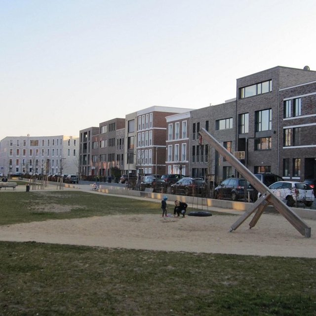
Estimation, source is another study

ភាពសម្បូរបែបនៃរុក្ខជាតិ
ថយចុះ
x
កើនឡើង

ការបំភាយនៃកាបូន និងឧស្ម័នផ្ទះកញ្ចក់
កើនឡើង
x
ថយចុះ


Increased carbon sequestration

Reduced hazard towards adverse events
None
x
None


If established green and blue corridors

ផលប៉ះពាល់ក្នុងបរិវេណ
សមត្ថភាពចម្រោះ (ដោយដី ដំណាំ ដីសើម)
កាត់បន្ថយ
x
ប្រសើរជាងមុន

ខូចខាតដល់ហេដ្ឋារចនាសម្ព័ន្ធសាធារណៈ/ឯកជន
កើនឡើង
x
កាត់បន្ថយ

Ways for infrastructure (e.g. water/sewage pipeline)
Shorter
x
Longer


Through the compact settlement structure

ការវិភាគថ្លៃដើម និងអត្ថប្រយោជន៍

អត្ថប្រយោជន៍បើប្រៀបធៀបនឹងថ្លៃដើមក្នុងការបង្កើតបច្ចេកទេស
អត្ថប្រយោជន៍បើប្រៀបធៀបនឹងថ្លៃដើមក្នុងការថែទាំបច្ចេកទេស

ការប្រែប្រួលអាកាសធាតុ

ការប្រែប្រួលអាកាសធាតុ
សីតុណ្ហភាពប្រចាំឆ្នាំ កើនឡើង

មិនល្អ
x
ល្អណាស់
គ្រោះអាកាសធាតុ (មហន្តរាយ) ​
ព្យុះភ្លៀងតាមតំបន់

មិនល្អ
x
ល្អណាស់
ព្យុះកំបុតត្បូងតាមតំបន់

មិនល្អ
ល្អណាស់
ចម្លើយ៖ មិនស្គាល់
រាំងស្ងួត

មិនល្អ
ល្អណាស់
ចម្លើយ៖ មិនស្គាល់
ទឹកជំនន់ទូទៅ (ទន្លេ)

មិនល្អ
ល្អណាស់
ចម្លើយ៖ មិនស្គាល់
ផលវិបាកដែលទាក់ទងនឹងបរិយាកាសផ្សេងៗទៀត
កាត់បន្ថយពេលដាំដុះ

មិនល្អ
x
ល្អណាស់

មិនល្អ
ល្អណាស់
ចម្លើយ៖ មិនស្គាល់

ការទទួលយក និងការបន្ស៊ាំ

ភាគរយនៃអ្នកប្រើប្រាស់ដីនៅតំបន់ដែលបានទទួលយកបច្ចេកទេស
  • តែមួយករណី /ពិសោធន៍
  • 1-10%
  • 11-50%
  • > 50%
ក្នុងចំណោមអ្នកទទួលយកបច្ចេកទេសនេះ តើមាន​ប៉ុន្មាន​ភាគរយ​ដែល​បាន​អនុវត្តន៍​ដោយ​មិន​បាន​ទទួលការលើក​ទឹកចិត្ត​ជាសម្ភារៈ?
  • 0-10%
  • 11-50%
  • 51-90%
  • 91-100%
តើថ្មីៗនេះ បច្ចេកទេសនេះត្រូវបានកែតម្រូវ​ដើម្បី​បន្ស៊ាំ​ទៅនឹង​ស្ថាន​ភាព​ប្រែប្រួល​ដែរ​ឬទេ?
  • បាទ/ចា៎
  • ទេ
ចំពោះលក្ខខណ្ឌប្រែប្រួលណាមួយដែលត្រូវបានបន្ស៊ាំ?
  • ការប្រែប្រួលអាកាសធាតុ/គ្រោះមហន្តរាយធម្មជាតិ
  • បម្រែបម្រួលទីផ្សារ
  • កម្លាំងពលកម្មដែលអាចរកបាន (ចំណាកស្រុក)

សេក្តីសន្និដ្ឋាន និងមេរៀនបទពិសោធន៍

ភាពខ្លាំង: ទស្សនៈអ្នកប្រើប្រាស់ដី
ភាពខ្លាំង: ទស្សនៈរបស់អ្នកចងក្រង ឬបុគ្គលសំខាន់ផ្សេងទៀត
  • Scenario simulations help to identify hot spots and can indicate regions where inner urban development should be pushed by public institutions.

    How can they be sustained / enhanced? Inner urban development is profitable if pressure on land is high but needs to be pushed also in regions with less pressure to protect soils, nature and climate.
  • Inner urban development can have positive impacts on climate adaptation

    How can they be sustained / enhanced? To reach positive impacts on climate adaptation issues it is necessary to establish green and blue climate corridors (e.g. network of urban greens established or optimized by re-vitalization of brownfields).
  • Inner urban development can rise the attractiveness of town (greater inner city mobility, compact town)

    How can they be sustained / enhanced? The technology improves inner-urban area development. For improvements to existing settlement areas, additional building activities (e.g. making buildings taller; concentrating housing) are possible. Side effects are a very concentrated settlement structure but with the advantage of reducing the sprawling out of settlements into agricultural land or wooded areas (i.e. outer development) and this saves GHG emissions and other ecosystem services ESS.
ចំណុចខ្សោយ/ គុណវិបត្តិ/ ហានិភ័យ​ : ទស្សនៈអ្នកប្រើប្រាស់ដីវិធីដោះស្រាយ
ចំណុចខ្សោយ/ គុណវិបត្តិ/ ហានិភ័យ​ : ទស្សនៈរបស់អ្នកចងក្រង ឬបុគ្គលសំខាន់ផ្សេងទៀតវិធីដោះស្រាយ
  • Nationwide simulation cannot indicate concrete lots where inner urban development should be pushed. The technology has shown the potential for Germany as a whole, but implementation depends on local authorities.

ឯកសារយោង

អ្នកចងក្រង
  • Johanna Fick
Editors
អ្នកត្រួតពិនិត្យ
  • Fabian Ottiger
  • David Streiff
  • Alexandra Gavilano
កាលបរិច្ឆេទនៃការអនុវត្ត: 28 ខែ កក្កដា ឆ្នាំ 2015
កែតម្រូវចុងក្រោយ: 1 ខែ មេសា ឆ្នាំ 2019
បុគ្គលសំខាន់ៗ
ការពណ៌នាលម្អិតក្នុងប្រព័ន្ធគ្រប់គ្រងទិន្នន័យរបស់វ៉ូខេត
ទិន្នន័យ SLM ភ្ជាប់ជាមួយ
ឯកសារនេះត្រូវបានសម្របសម្រួលដោយ
ស្ថាប័ន៖ គម្រោង
ឯកសារយោងសំខាន់ៗ
  • www.cc-landstrad.de:
  • www.bbsr.bund.de:
ការភ្ជាប់ទៅកាន់ពត៌មានពាក់ព័ន្ធលើប្រព័ន្ធអនឡាញ
  • www.cc-landstrad.de: None
  • www.bbsr.bund.de: None
This work is licensed under Creative Commons Attribution-NonCommercial-ShareaAlike 4.0 International