Gully plugging using check dams
(ប្រទេសនេប៉ាល់)
Galchhi niyantran - Nepali
ការពណ៌នា
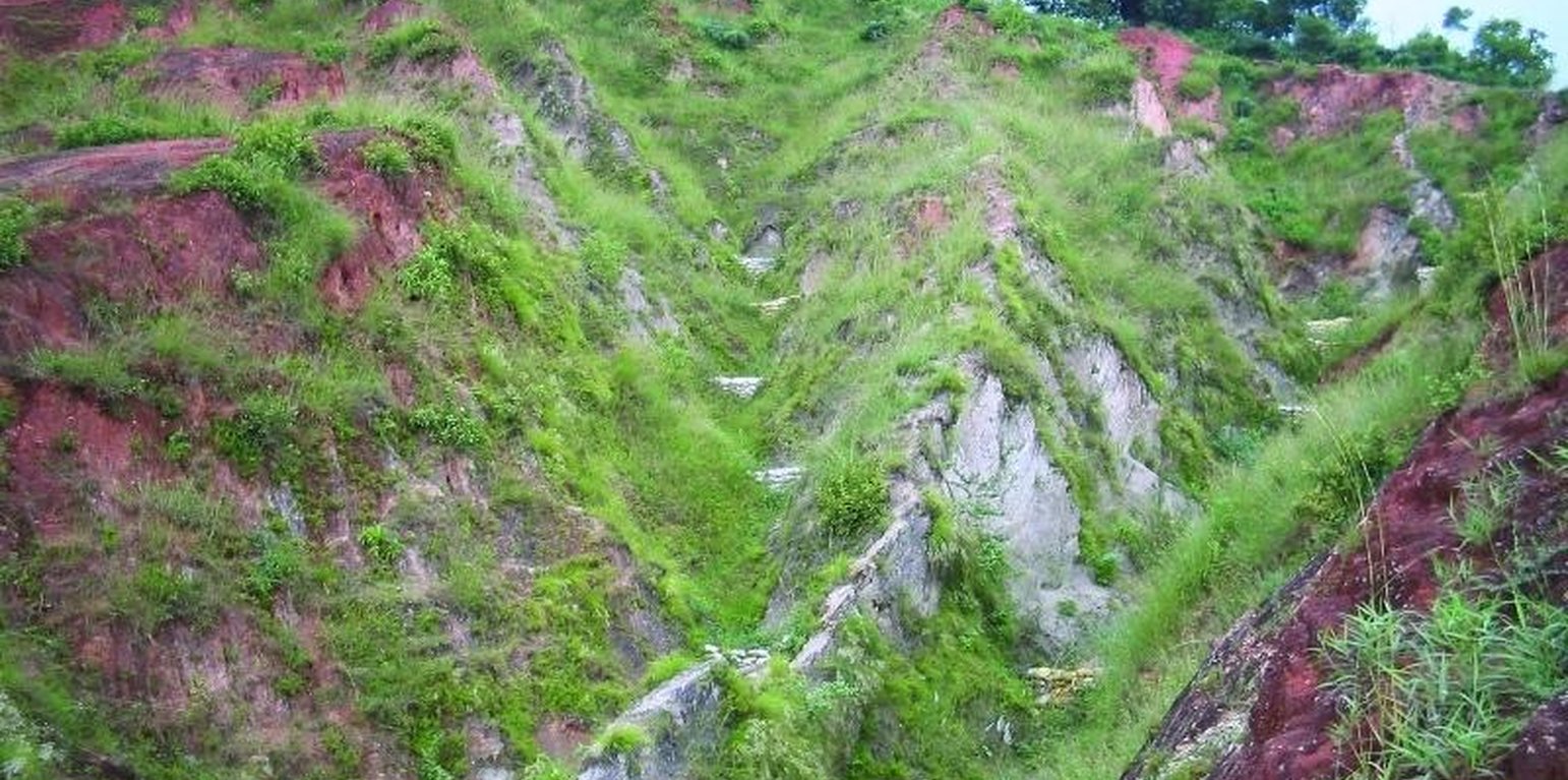
Small dam structures constructed across erosion gullies
Check dams are small low structures built across a gully or a channel to prevent them from deepening further. These small dams reduce the speed of water flow and minimise the erosive power of runoff. They also promote the deposition of eroded materials to further stabilise the gullies.
Two gullies adjacent to a degraded area of communal grazing land were controlled by constructing check dams and with vegetative measures including planting bamboo. The main purpose was to control the further development of the gullies, which were affecting the adjacent grazing land and blocking a downstream irrigation channel. The site is community land used by the 40 households (240 people) of Dhotra village in the intensively used Jhikhu Khola watershed. Irrigated cropland lies downstream from the site, whilst the site itself is bordered by grazing land, degraded sal-dominated forest, and rainfed forward-sloping terraces.
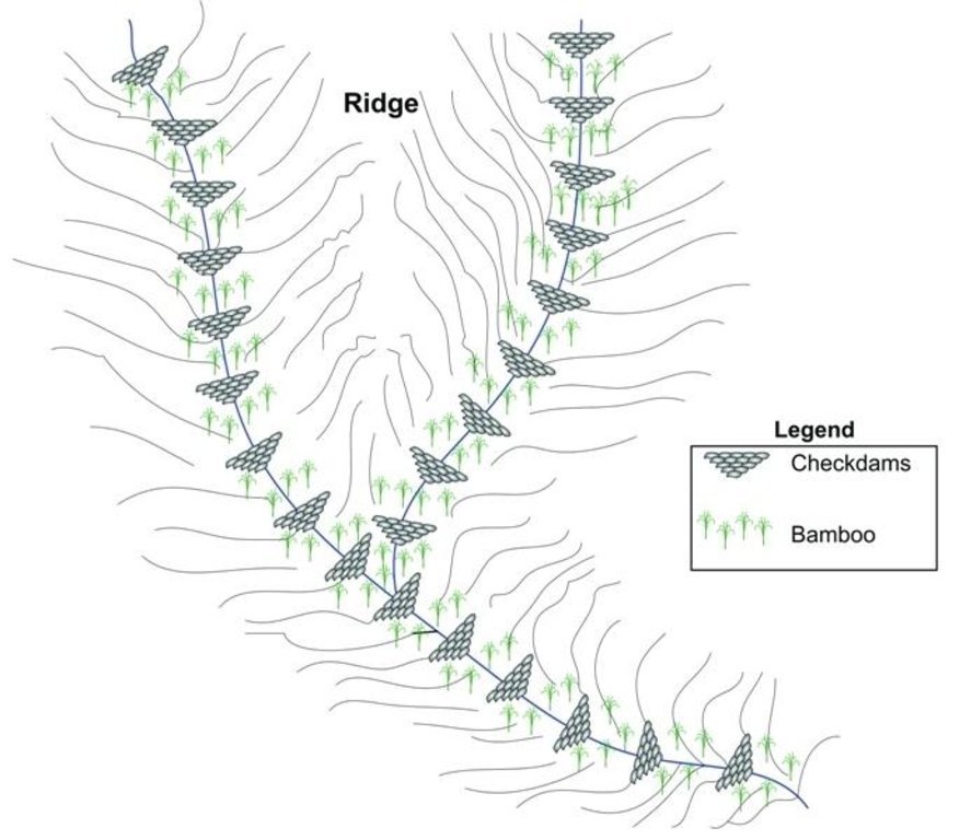
The check dams were made of old cement bags filed with soil and were 1m high with 0.5m deep foundations. The check dams were spaced so that a line joining the top of two adjacent dams had about a 3% slope gradient. Twenty-four check dams were built in the two gullies using a total of 2400 filled cement bags. Forty clumps of bamboo were planted between the dams for stabilisation.
All that is needed to maintain this technology is to inspect the condition of the check dams occasionally, especially before and after the monsoon. Displaced bags should be replaced and the water courses cleared of branches and big stones. Further planting should be carried out if needed.
The case study area has a distinct dry season from November to May and a wet monsoon period from June to October. Annual rainfall is around 1200 mm. The site has red soils that are highly weathered and, if not properly managed, are very susceptible to erosion.
ទីតាំង
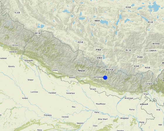
ទីតាំង: Kavre Palanchok/ Dhotra village, Jhikhu Khola watershed, ប្រទេសនេប៉ាល់
ចំនួនទីកន្លែងបច្ចេកទេស ដែលវិភាគ:
ចំណុចយោងភូមិសាស្ត្រនៃទីតាំងជ្រើសរើស
ការសាយភាយនៃបច្ចេកទេស: ត្រូវបានផ្សព្វផ្សាយត្រឹមតំបន់មួយ (0.006 km²)
តើស្ថិតក្នុងតំបន់ការពារអចិន្ត្រៃយ៍?:
កាលបរិច្ឆេទនៃការអនុវត្ត: 10-50 ឆ្នាំ
ប្រភេទនៃការណែនាំឱ្យអនុវត្តន៍៖
-
តាមរយៈការបង្កើតថ្មីរបស់អ្នកប្រើប្រាស់ដី
-
ជាផ្នែកនៃប្រព័ន្ធប្រពៃណី (> 50 ឆ្នាំ)
-
ពេលកំពុងពិសោធន៍
-
តាមរយៈគម្រោង / អន្តរាគមន៍ពីខាងក្រៅ
គោលបំណងចម្បងៗ
-
ធ្វើឱ្យប្រសើរឡើងនូវផលិតកម្ម
-
កាត់បន្ថយ, បង្ការ, ស្តារឡើងវិញនូវការធ្លាក់ចុះគុណភាពដី
-
អភិរក្សប្រព័ន្ធអេកូឡូស៊ី
-
ការពារតំបន់ទីជម្រាល/តំបន់ខ្សែទឹកខាងក្រោមបញ្ចូលជាមួយបច្ចេកទេសផ្សេងទៀត
-
អភិរក្ស/ធ្វើឱ្យប្រសើរឡើងជីវចម្រុះ
-
កាត់បន្ថយហានិភ័យនៃគ្រោះមហន្តរាយ
-
បន្ស៊ាំទៅនឹងការប្រែប្រួលអាកាសធាតុ/គ្រោះមហន្តរាយ និងផលប៉ះពាល់របស់វា
-
កាត់បន្ថយការប្រែប្រួលអាកាសធាតុ និងផលប៉ះពាល់របស់វា
-
បង្កើតផលប្រយោជន៍សេដ្ឋកិច្ច
-
បង្កើតផលប្រយោជន៍សង្គម
-
reduce land loss
ការប្រើប្រាស់ដី
ការផ្គត់ផ្គង់ទឹក
-
ទឹកភ្លៀង
-
ទឹកភ្លៀង និងប្រព័ន្ធស្រោចស្រព
-
ប្រព័ន្ធស្រោចស្រពទាំងស្រុង
គោលបំណងទាក់ទងនឹងការធ្លាក់ចុះគុណភាពដី
-
ការការពារការធ្លាក់ចុះគុណភាពដី
-
ការកាត់បន្ថយការធ្លាក់ចុះគុណភាពដី
-
ការជួសជុល/ ស្តារឡើងវិញនៃឱនភាពដីធ្ងន់ធ្ងរ
-
ការបន្ស៊ាំទៅនឹងការធ្លាក់ចុះគុណភាពដី
-
ដែលមិនអាចអនុវត្តបាន
ប្រភេទនៃការធ្លាក់ចុះគុណភាពដីដែលបានដោះស្រាយ
-
ការហូរច្រោះដីដោយសារទឹក - Wg: ការកកើតឡើងនូវកំទេចកំទីដីស្រទាប់ក្រោម, Wo: ផលប៉ះពាល់នៃការធ្លាក់ចុះគុណភាពកន្លែងឆ្ងាយ
ក្រុម SLM
-
ធ្វើឱ្យប្រសើរឡើងគម្របដី/ ដំណាំគម្របដី
-
វិធានការអនុវត្តកាត់ទទឹងទីជម្រាល
វិធានការ SLM
-
វិធានការរុក្ខជាតិ - V1: ឈើធំៗ និងដើមឈើតូចៗ
-
វិធានការរចនាស័ម្ពន្ធ - S5: ទំនប់ ថ្លុក ស្រះ
គំនូរបច្ចេកទេស
លក្ខណៈបច្ចេកទេស
Schematic drawing of two gullies with 24 check dams and bamboo planted below the check dams for stabilisation
Location: Dhotra. Khabre
Date: 22.6.06
Technical knowledge required for field staff / advisors: low
Technical knowledge required for land users: low
Main technical functions: control of dispersed runoff: impede / retard, sediment retention / trapping, sediment harvesting
Secondary technical functions: reduction of slope angle, increase of infiltration
Scattered / dispersed
Vegetative material: T : trees / shrubs
Number of plants per (ha): 40
Vertical interval between rows / strips / blocks (m): 4 m
Trees/ shrubs species: Bamboo
Slope (which determines the spacing indicated above): 30.00%
If the original slope has changed as a result of the Technology, the slope today is (see figure below): 25.00%
Dam/ pan/ pond
Vertical interval between structures (m): 4 m
Construction material (earth): soil resulting from digging activities from the adjacent grassland was used to fill cement bags for
Slope (which determines the spacing indicated above): 30%
If the original slope has changed as a result of the Technology, the slope today is: 25%
Vegetation is used for stabilisation of structures.
Author: I. Providoli, A.K.Thaku ICIMOD
ការបង្កើតនិងការថែទាំ៖ សកម្មភាព ធាតុចូល និងថ្លៃដើម
ការគណនាធាតុចូល និងថ្លៃដើម
- ថ្លៃដើមត្រូវបានគណនា៖
- រូបិយប័ណ្ណសម្រាប់ការគណនាថ្លៃដើម៖ Nepali Rupee
- អត្រាប្តូរប្រាក់ (ទៅជាដុល្លារអាមេរិក)៖ 1 USD = 73.0 Nepali Rupee
- ថ្លៃឈ្នួលជាមធ្យមក្នុង ១ ថ្ងៃ៖ 2.00
កត្តាសំខាន់បំផុតដែលមានឥទ្ធិពលលើថ្លៃដើម
មិនមាន
សកម្មភាពបង្កើតបច្ចេកទេស
-
Plantating of bamboo plants (clumps) below the check dams (ពេលវេលា/ ភាពញឹកញាប់: before onset of monsoon (June))
-
Placing filled cement bags across gullies to form checkdams (ពេលវេលា/ ភាពញឹកញាប់: before onset of monsoon (June))
-
Filling cement bag with soil (ពេលវេលា/ ភាពញឹកញាប់: before onset of monsoon (June))
-
Digging trenches for dam foundations (ពេលវេលា/ ភាពញឹកញាប់: before onset of monsoon (June))
ធាតុចូល និងថ្លៃដើមសម្រាប់ការបង្កើតបច្ចេកទេស
| បញ្ជាក់ពីធាតុចូល |
ឯកតា |
បរិមាណ |
ថ្លៃដើមក្នុងមួយឯកតា (Nepali Rupee) |
ថ្លៃធាតុចូលសរុប (Nepali Rupee) |
% នៃថ្លៃដើមដែលចំណាយដោយអ្នកប្រើប្រាស់ដី |
|
កម្លាំងពលកម្ម
|
| Building dams and planting bamboo |
Persons/day |
18,0 |
2,0 |
36,0 |
100,0 |
|
សម្ភារៈសាងសង់
|
| Cement bags |
ha |
1,0 |
73,0 |
73,0 |
|
|
ផ្សេងៗ
|
| Lunch, tea for farmers |
ha |
1,0 |
16,0 |
16,0 |
|
| Transportation |
ha |
1,0 |
14,0 |
14,0 |
|
| ថ្លៃដើមសរុបក្នុងការបង្កើតបច្ចេកទេស |
139.0 |
|
| ថ្លៃដើមសរុបក្នុងការបង្កើតបច្ចេកទេសគិតជាដុល្លារ |
1.9 |
|
សកម្មភាពថែទាំ
-
Maintaining gullies: repair or replace damaged check dams, plant (ពេលវេលា/ ភាពញឹកញាប់: before onset of monsoon (June))
-
Ensuring good drainage for bamboo (ពេលវេលា/ ភាពញឹកញាប់: before onset of monsoon (June))
-
Maintaining gullies: repair or replace damaged check dams,plant more grassesor trees if needed (ពេលវេលា/ ភាពញឹកញាប់: before onset of monsoon (June)/once a year)
បរិស្ថានធម្មជាតិ
បរិមាណទឹកភ្លៀងជាមធ្យមប្រចាំឆ្នាំ
-
< 250 មម
-
251-500 មម
-
501-750 មម
-
751-1,000 មម
-
1,001-1,500 មម
-
1,501-2,000 មម
-
2,001-3,000 មម
-
3,001-4,000 មម
-
> 4,000 មម
តំបន់កសិអាកាសធាតុ
-
សើម
-
មានភ្លៀងមធ្យម
-
មានភ្លៀងតិចតួច
-
ស្ងួត
លក្ខណៈសម្គាល់នៃអាកាសធាតុ
Thermal climate class: subtropics
ជម្រាល
-
រាបស្មើ (0-2%)
-
ជម្រាលតិចតួច (3-5%)
-
មធ្យម (6-10%)
-
ជម្រាលខ្ពស់បន្តិច (11-15%)
-
ទីទួល (16-30%)
-
ទីទួលចោត (31-60%)
-
ទីទួលចោតខ្លាំង (>60%)
ទម្រង់ដី
-
ខ្ពង់រាប
-
កំពូលភ្នំ
-
ជម្រាលភ្នំ
-
ជម្រាលទួល
-
ជម្រាលជើងភ្នំ
-
បាតជ្រលងភ្នំ
រយៈកម្ពស់ធៀបនឹងនីវ៉ូទឹកសមុទ្រ
-
0-100 ម
-
101-500 ម
-
501-1,000 ម
-
1,001-1,500 ម
-
1,501-2,000 ម
-
2,001-2,500 ម
-
2,501-3,000 ម
-
3,001-4,000 ម
-
> 4,000 ម
បច្ចេកទេសត្រូវបានអនុវត្តនៅក្នុង
-
សណ្ឋានដីប៉ោង
-
សណ្ឋានដីផត
-
មិនពាក់ព័ន្ធទាំងអស់
ជម្រៅដី
-
រាក់ខ្លាំង (0-20 សម)
-
រាក់ (21-50 សម)
-
មធ្យម (51-80 សម)
-
ជ្រៅ (81-120 សម)
-
ជ្រៅខ្លាំង (> 120 សម)
វាយនៈភាពដី (ដីស្រទាប់ខាងលើ)
-
គ្រើម/ មានពន្លឺ (ខ្សាច់)
-
មធ្យម (ល្បាយ, ល្បាប់)
-
ម៉ត់/ ធ្ងន់ (ឥដ្ឋ)
វាយនភាពដី (> 20 សម ក្រោមស្រទាប់លើ)
-
គ្រើម/ មានពន្លឺ (ខ្សាច់)
-
មធ្យម (ល្បាយ, ល្បាប់)
-
ម៉ត់/ ធ្ងន់ (ឥដ្ឋ)
កម្រិតសារធាតុសរីរាង្គក្នុងដីស្រទាប់លើ
-
ខ្ពស់ (>3%)
-
មធ្យម (1-3%)
-
ទាប (<1%)
ដង្ហើមទឹកក្នុងដី
-
ផ្ទៃខាងលើ
-
< 5 ម
-
5-50 ម
-
> 50 ម
ភាពអាចរកបាននៃទឹកលើដី
-
លើស
-
ល្អ
-
កម្រិតមធ្យម
-
មិនមាន/ គ្មាន
គុណភាពទឹក (មិនបានធ្វើប្រព្រឹត្តិកម្ម)
-
ទឹកពិសារដែលមានគុណភាពល្អ
-
ទឹកពិសារដែលគ្មានគុណភាព (តម្រូវឱ្យមានការសំអាត)
-
ទឹកសម្រាប់តែការធ្វើកសិកម្ម (ស្រោចស្រព)
-
ទឹកមិនអាចប្រើប្រាស់បាន
គុណភាពទឹក គឺផ្តោតទៅលើ៖
តើមានបញ្ហាទឹកប្រៃហូរចូលដែរឬទេ?
ការកើតឡើងនៃទឹកជំនន់
ភាពសំបូរបែបនៃជម្រកធម្មជាតិ
ចរិតលក្ខណៈរបស់អ្នកប្រើប្រាស់ដីដែលប្រើបច្ចេកទេស SLM
ទីផ្សារ
-
សម្រាប់ហូបក្នុងគ្រួសារ (ផ្គត់ផ្គង់ខ្លួនឯង)
-
ពាក់កណ្តាលពាណិជ្ជកម្ម (ផ្គត់ផ្គង់ខ្លួនឯង/ ពាណិជ្ជកម្ម)
-
ពាណិជ្ជកម្ម/ ទីផ្សារ
ចំណូលក្រៅកសិដ្ឋាន
-
តិចជាង 10% នៃចំណូល
-
10-50% នៃចំណូល
-
ច្រើនជាង 50% នៃចំណូល
កម្រិតជីវភាព
-
មិនល្អខ្លាំង
-
មិនល្អ
-
មធ្យម
-
មាន
-
មានខ្លាំង
កម្រិតនៃការប្រើគ្រឿងយន្ត
-
ប្រើកម្លាំងពលកម្ម
-
ប្រើកម្លាំងសត្វ
-
គ្រឿងយន្ត/ ម៉ាស៊ីន
នៅមួយកន្លែង ឬពនេចរ
-
នៅមួយកន្លែង
-
ពាក់កណ្តាលពនេចរ
-
ពនេចរ
បុគ្គល ឬក្រុម
-
ធ្វើខ្លួនឯង/ គ្រួសារ
-
ជាក្រុម/ សហគមន៍
-
សហករ
-
មានបុគ្គលិក (ក្រុមហ៊ុន, រដ្ឋ)
អាយុ
-
កុមារ
-
យុវវ័យ
-
វ័យកណ្តាល
-
មនុស្សចាស់
ផ្ទៃដីប្រើប្រាស់ក្នុងមួយគ្រួសារ
-
< 0.5 ហិកតា
-
0.5-1 ហិកតា
-
1-2 ហិកតា
-
2-5 ហិកតា
-
5-15 ហិកតា
-
15-50 ហិកតា
-
50-100 ហិកតា
-
100-500 ហិកតា
-
500-1,000 ហិកតា
-
1,000-10,000 ហិកតា
-
> 10,000 ហិកតា
មាត្រដ្ឋាន
-
ខ្នាតតូច
-
ខ្នាតមធ្យម
-
ខ្នាតធំ
ភាពជាម្ចាស់ដីធ្លី
-
រដ្ឋ
-
ក្រុមហ៊ុន
-
ភូមិ
-
ក្រុម
-
ឯកជន មិនមានកម្មសិទ្ធ
-
ឯកជន មានកម្មសិទ្ធ
សិទ្ធិប្រើប្រាស់ដី
-
អាស្រ័យផលសេរី (មិនមានការកំណត់)
-
ជាក្រុម (មានដែនកំណត់)
-
កិច្ចសន្យាជួល
-
ឯកជន
សិទ្ធិប្រើប្រាស់ទឹក
-
អាស្រ័យផលសេរី (មិនមានការកំណត់)
-
ជាក្រុម (មានដែនកំណត់)
-
កិច្ចសន្យាជួល
-
ឯកជន
ប្រើប្រាស់សេវាកម្ម និងហេដ្ឋារចនាសម្ព័ន្ធ
ផលប៉ះពាល់
ផលប៉ះពាល់វប្បធម៌សង្គម
ចំណេះដឹង SLM / ការធ្លាក់ចុះគុណភាពដី
ការកាត់បន្ថយជម្លោះ
អាក្រក់ជាងមុន
ប្រសើរជាងមុន
At the beginning a few people opposed the activities.
ផលប៉ះពាល់ក្នុងបរិវេណ
កំណកល្បាប់ខ្សែទឹកខាងក្រោម
ការវិភាគថ្លៃដើម និងអត្ថប្រយោជន៍
អត្ថប្រយោជន៍បើប្រៀបធៀបនឹងថ្លៃដើមក្នុងការបង្កើតបច្ចេកទេស
រយៈពេលខ្លី
អវិជ្ជមានខ្លាំង
វិជ្ជមានខ្លាំង
រយៈពេលវែង
អវិជ្ជមានខ្លាំង
វិជ្ជមានខ្លាំង
អត្ថប្រយោជន៍បើប្រៀបធៀបនឹងថ្លៃដើមក្នុងការថែទាំបច្ចេកទេស
រយៈពេលខ្លី
អវិជ្ជមានខ្លាំង
វិជ្ជមានខ្លាំង
រយៈពេលវែង
អវិជ្ជមានខ្លាំង
វិជ្ជមានខ្លាំង
ការប្រែប្រួលអាកាសធាតុ
ការប្រែប្រួលអាកាសធាតុ
សីតុណ្ហភាពប្រចាំឆ្នាំ កើនឡើង
គ្រោះអាកាសធាតុ (មហន្តរាយ)
ផលវិបាកដែលទាក់ទងនឹងបរិយាកាសផ្សេងៗទៀត
ការទទួលយក និងការបន្ស៊ាំ
ភាគរយនៃអ្នកប្រើប្រាស់ដីនៅតំបន់ដែលបានទទួលយកបច្ចេកទេស
-
តែមួយករណី /ពិសោធន៍
-
1-10%
-
11-50%
-
> 50%
ក្នុងចំណោមអ្នកទទួលយកបច្ចេកទេសនេះ តើមានប៉ុន្មានភាគរយដែលបានអនុវត្តន៍ដោយមិនបានទទួលការលើកទឹកចិត្តជាសម្ភារៈ?
-
0-10%
-
11-50%
-
51-90%
-
91-100%
ចំនួនខ្នងផ្ទះ និង/ឬតំបន់ដែលគ្របដណ្តប់
40 households in an area of 0.006 sq km
តើថ្មីៗនេះ បច្ចេកទេសនេះត្រូវបានកែតម្រូវដើម្បីបន្ស៊ាំទៅនឹងស្ថានភាពប្រែប្រួលដែរឬទេ?
ចំពោះលក្ខខណ្ឌប្រែប្រួលណាមួយដែលត្រូវបានបន្ស៊ាំ?
-
ការប្រែប្រួលអាកាសធាតុ/គ្រោះមហន្តរាយធម្មជាតិ
-
បម្រែបម្រួលទីផ្សារ
-
កម្លាំងពលកម្មដែលអាចរកបាន (ចំណាកស្រុក)
សេក្តីសន្និដ្ឋាន និងមេរៀនបទពិសោធន៍
ភាពខ្លាំង: ទស្សនៈអ្នកប្រើប្រាស់ដី
-
Reduced soil erosion, rill erosion, and top soil loss
How can they be sustained / enhanced? Regular maintenance of the structure and grasses is required
-
The technology is easy to maintain.
How can they be sustained / enhanced? As above
ភាពខ្លាំង: ទស្សនៈរបស់អ្នកចងក្រង ឬបុគ្គលសំខាន់ផ្សេងទៀត
-
It's a low cost technology , easy to apply, little knowledge needed.
How can they be sustained / enhanced? Regular maintenance of the structure and grasses is required
-
The effect of the technology can be seen easily.
How can they be sustained / enhanced? As above
ចំណុចខ្សោយ/ គុណវិបត្តិ/ ហានិភ័យ : ទស្សនៈអ្នកប្រើប្រាស់ដីវិធីដោះស្រាយ
ចំណុចខ្សោយ/ គុណវិបត្តិ/ ហានិភ័យ : ទស្សនៈរបស់អ្នកចងក្រង ឬបុគ្គលសំខាន់ផ្សេងទៀតវិធីដោះស្រាយ
ឯកសារយោង
អ្នកត្រួតពិនិត្យ
-
David Streiff
-
Alexandra Gavilano
កាលបរិច្ឆេទនៃការអនុវត្ត: 6 ខែ មិថុនា ឆ្នាំ 2011
កែតម្រូវចុងក្រោយ: 3 ខែ មិថុនា ឆ្នាំ 2019
បុគ្គលសំខាន់ៗ
-
Nicole Guedel - អ្នកជំនាញឯកទេស SLM
-
Madhav Dhakal - អ្នកជំនាញឯកទេស SLM
-
Isabelle Providoli - អ្នកជំនាញឯកទេស SLM
ការពណ៌នាលម្អិតក្នុងប្រព័ន្ធគ្រប់គ្រងទិន្នន័យរបស់វ៉ូខេត
ឯកសារនេះត្រូវបានសម្របសម្រួលដោយ
ស្ថាប័ន៖
- ICIMOD International Centre for Integrated Mountain Development (ICIMOD) - ប្រទេសនេប៉ាល់
គម្រោង
- People and Resource Dynamics Project, Nepal (PARDYP)
ឯកសារយោងសំខាន់ៗ
-
Nakarmi, G. (2000) Soil Erosion Dynamics in the Middle Mountains of Nepal, a report submitted to PARDYP, ICIMOD, Kathmandu: ICIMOD
-
Schreier, H.; Brown, S.; Shah, P. B.; Shrestha, B.; Merz, J. (2002) Jhikhu Khola Watershed – Nepal, CD ROM. Vancouver: Institute for Resources and Environment, University of British Columbia.: ICIMOD
-
Shrestha, B. (2004) Progress Report PARDYP- Nepal. Paper presented at the PARDYP Access Mid Year Meeting, 19-22 July 2004, ICIMOD, Kathmandu: ICIMOD