Adding manure to the pits (tassa) before planting. (William Critchley)

Planting pits and stone lines (ប្រទេសនីហ្សេ)

Tassa avec cordon pierreux (french)

ការពណ៌នា

Rehabilitation of degraded land through manured planting pits, in combination with contour stone lines. The planting pits are used for millet and sorghum production on gentle slopes.

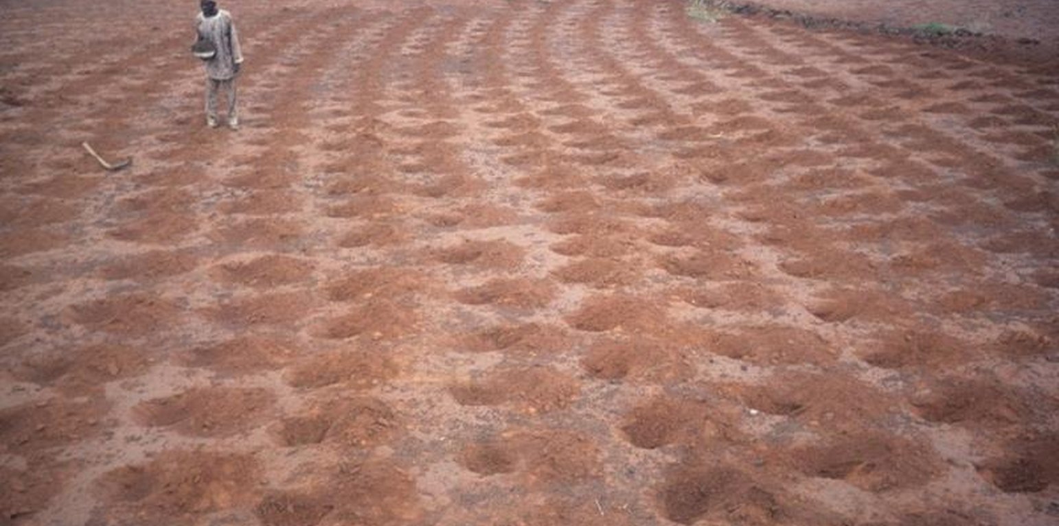
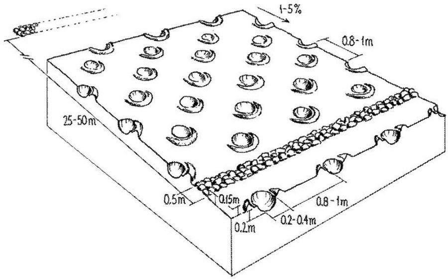
The combination of planting pits (tassa) with stone lines is used for the rehabilitation of degraded, crusted land. This technology is mainly applied in semi-arid areas on sandy/loamy plains, often covered with a hard pan, and with slopes below 5%. These denuded plains are brought into crop cultivation by the combination of tassa and stone lines. Planting pits are holes of 20-30 cm diameter and 20-25 cm depth, spaced about 1 m apart in each direction. The excavated earth is formed into a small ridge downslope of the pit. Manure is added to each pit, but its availability is sometimes a problem. At the start of the rainy season, millet or sorghum is sown in these pits. The overall aim of the system is to capture and hold
rainfall and runoff, and thereby improve water infiltration, while increasing nutrient availability.
Stone lines are small structures, at most three stones wide and sometimes only one stone high. The distance between the lines is a function of the slope and availability of stone. Typically they are sited 25-50 m apart on 2-5% slopes. Stones are usually collected from nearby sites - though sometimes up to 5-10 km away and brought to the fields by donkey carts or lorries (when a project is involved). They are positioned manually, along the contour. Stone lines are intended to slow down runoff. They thereby increase the rate of infiltration, while simultaneously protecting the planting pits from sedimentation.
Often grass establishes between the stones, which helps increase infiltration further and accelerates the accumulation of fertile sediment. Wind-blown particles may also build up along the stone lines due to a local reduction in wind velocity. The accumulation of sediment along the stone lines in turn favours water infiltration on the upslope side. This then improves plant growth, which further enhances the effect of the system. Construction does not require heavy machinery (unless the stones need to be brought from afar by lorry).
The technique is therefore favourable to spontaneous adoption. Stone lines may need to be repaired annually, especially if heavy rains have occurred. Manure is placed every second (or third) year into the previously dug pits and sand is removed annually: normally the highest plant production is during the second year after manure application.

ទីតាំង

ទីតាំង: Niger, Tahoua, ប្រទេសនីហ្សេ

ចំនួនទីកន្លែងបច្ចេកទេស ដែលវិភាគ:

ចំណុចយោងភូមិសាស្ត្រនៃទីតាំងជ្រើសរើស
  • មិនមាន

ការសាយភាយនៃបច្ចេកទេស: ត្រូវបានផ្សព្វផ្សាយត្រឹមតំបន់មួយ (40.0 km²)

តើស្ថិតក្នុងតំបន់ការពារអចិន្ត្រៃយ៍?:

កាលបរិច្ឆេទនៃការអនុវត្ត:

ប្រភេទនៃការណែនាំឱ្យអនុវត្តន៍៖
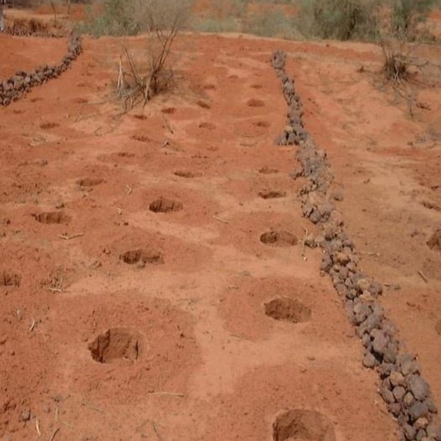
Stone lines in combination with tassa: the two measures act together to capture runoff and improve plant performance. (Charles Bielders)

ចំណាត់ថ្នាក់នៃបច្ចេកទេស

គោលបំណងចម្បងៗ
  • ធ្វើឱ្យប្រសើរឡើងនូវផលិតកម្ម
  • កាត់បន្ថយ, បង្ការ, ស្តារឡើងវិញនូវការធ្លាក់ចុះគុណភាពដី
  • អភិរក្សប្រព័ន្ធអេកូឡូស៊ី
  • ការពារតំបន់ទីជម្រាល/តំបន់ខ្សែទឹកខាងក្រោមបញ្ចូលជាមួយបច្ចេកទេសផ្សេងទៀត
  • អភិរក្ស/ធ្វើឱ្យប្រសើរឡើងជីវចម្រុះ
  • កាត់បន្ថយហានិភ័យនៃគ្រោះមហន្តរាយ
  • បន្ស៊ាំទៅនឹងការប្រែប្រួលអាកាសធាតុ/គ្រោះមហន្តរាយ និងផលប៉ះពាល់របស់វា
  • កាត់បន្ថយការប្រែប្រួលអាកាសធាតុ និងផលប៉ះពាល់របស់វា
  • បង្កើតផលប្រយោជន៍សេដ្ឋកិច្ច
  • បង្កើតផលប្រយោជន៍សង្គម
ការប្រើប្រាស់ដី

  • ដីដាំដំណាំ
    • ដំណាំប្រចាំឆ្នាំ: ធញ្ញជាតិ -​ ពោតសាលី, ធញ្ញជាតិ - ពោតសាលី, ពពួកសណ្តែក - គ្រាប់ហោឡាំងតាវ

ការផ្គត់ផ្គង់ទឹក
  • ទឹកភ្លៀង
  • ទឹកភ្លៀង និងប្រព័ន្ធស្រោចស្រព
  • ប្រព័ន្ធស្រោចស្រពទាំងស្រុង

គោលបំណងទាក់ទងនឹងការធ្លាក់ចុះគុណភាពដី
  • ការការពារការធ្លាក់ចុះគុណភាពដី
  • ការកាត់បន្ថយការធ្លាក់ចុះគុណភាពដី
  • ការជួសជុល/ ស្តារឡើងវិញនៃឱនភាពដីធ្ងន់ធ្ងរ
  • ការបន្ស៊ាំទៅនឹងការធ្លាក់ចុះគុណភាពដី
  • ដែលមិនអាចអនុវត្តបាន
ប្រភេទនៃការធ្លាក់ចុះគុណភាពដីដែលបានដោះស្រាយ
  • ការហូរច្រោះដីដោយសារទឹក - Wt: ការបាត់ដីស្រទាប់លើដោយការហូរច្រោះ
  • ការបាត់ដីដោយសារខ្យល់ - Et: ការបាត់បង់ដីស្រទាប់លើ
  • ការធ្លាក់ចុះសារធាតុគីមីក្នុងដី - Cn: ការថយចុះជីជាតិ និងកាត់បន្ថយបរិមាណសារធាតុសរីរាង្គ (មិនកើតឡើងដោយការហូរច្រោះទេ)
  • ការបាត់បង់រូបសាស្ត្រនៃដី - Pc: ការហាប់ណែន , Pk: ការបិទរន្ធដី
ក្រុម SLM
  • ការស្តុកទុកទឹក
  • ការគ្រប់គ្រងប្រព័ន្ធស្រោចស្រព (រួមទាំងការផ្គត់ផ្គង់ទឹក ប្រព័ន្ធបង្ហូរ)
វិធានការ SLM
  • វិធានការក្សេត្រសាស្ត្រ - A7: ផ្សេងៗ
  • វិធានការរចនាស័ម្ពន្ធ - S11: ផ្សេងៗ

គំនូរបច្ចេកទេស

លក្ខណៈបច្ចេកទេស
Planting pits (tassa) capture rainfall runoff for cultivation of annual crops, and the stone lines - spaced at 25-50 metres apart - help hold back moisture and eroded soil.

Technical knowledge required for field staff / advisors: moderate

Technical knowledge required for land users: low

Main technical functions: increase in organic matter, increase of infiltration, increase / maintain water stored in soil, water harvesting / increase water supply, increase in soil fertility, increases natural regeneration of trees

Secondary technical functions: reduction of slope length, improvement of ground cover, improvement of soil structure

Manure / compost / residues
Quantity/ density: 2.5 t/ha

Structural measure: stone lines
Spacing between structures (m): 25-50planting pits

Structural measure: planting pits
Vertical interval between structures (m): 1
Spacing between structures (m): 1
Depth of ditches/pits/dams (m): 0.2-0.25
Width of ditches/pits/dams (m): 0.2-0.3

Slope (which determines the spacing indicated above): <5%
Author: Mats Gurtner

ការបង្កើតនិងការថែទាំ៖​ សកម្មភាព ធាតុចូល និងថ្លៃដើម

ការគណនាធាតុចូល​ និងថ្លៃដើម
  • ថ្លៃដើមត្រូវបានគណនា៖
  • រូបិយប័ណ្ណសម្រាប់ការគណនាថ្លៃដើម៖ ដុល្លារ
  • អត្រាប្តូរប្រាក់ (ទៅជាដុល្លារអាមេរិក)៖ 1 USD = មិនមាន
  • ថ្លៃឈ្នួលជាមធ្យមក្នុង ១ ថ្ងៃ៖ មិនមាន
កត្តាសំខាន់បំផុតដែលមានឥទ្ធិពលលើថ្លៃដើម
មិនមាន
សកម្មភាពបង្កើតបច្ចេកទេស
  1. Digging pits (tassa): the excavated earth (ពេលវេលា/ ភាពញឹកញាប់: dry season (November to May))
  2. Digging out stones from nearby sites (ពេលវេលា/ ភាពញឹកញាប់: dry season (November to May))
  3. Transporting stones (ពេលវេលា/ ភាពញឹកញាប់: dry season (November to May))
  4. Aligning the stones along the contour with the help of a ‘water tube (ពេលវេលា/ ភាពញឹកញាប់: dry season (November to May))
ធាតុចូល និងថ្លៃដើមសម្រាប់ការបង្កើតបច្ចេកទេស
បញ្ជាក់ពីធាតុចូល ឯកតា បរិមាណ ថ្លៃដើមក្នុងមួយឯកតា (ដុល្លារ) ថ្លៃធាតុចូលសរុប (ដុល្លារ) % នៃថ្លៃដើមដែលចំណាយដោយអ្នកប្រើប្រាស់ដី
កម្លាំងពលកម្ម
Digging tassa persons/day/ha 100,0 1,5 150,0 100,0
Building stone lines persons/day/ha 26,666 1,5 40,0 100,0
សម្ភារៈ
Tools for tassa ha 1,0 5,0 5,0 100,0
Tools for stone lines ha 1,0 5,0 5,0 75,0
ជី និងសារធាតុពុល
Compost/manure ha 1,0 5,0 5,0 100,0
ផ្សេងៗ
Transporting stones with lorri ha 1,0 40,0 40,0
ថ្លៃដើមសរុបក្នុងការបង្កើតបច្ចេកទេស 245.0
ថ្លៃដើមសរុបក្នុងការបង្កើតបច្ចេកទេសគិតជាដុល្លារ 245.0
សកម្មភាពថែទាំ
  1. Manuring the pits with approx 250 g per pit (ពេលវេលា/ ភាពញឹកញាប់: dry season (November to May) / initial establishment)
  2. Manuring the pits with about 250 g per pit (2.5 t/ha) (ពេលវេលា/ ភាពញឹកញាប់: October/November or March-May / every second year)
  3. Removing sand from the tassa (ពេលវេលា/ ភាពញឹកញាប់: March-May/annual)
  4. Check and repair stone lines (ពេលវេលា/ ភាពញឹកញាប់: annually and after heavy rains.)
ធាតុចូលនិងថ្លៃដើមសម្រាប់ការថែទាំ
បញ្ជាក់ពីធាតុចូល ឯកតា បរិមាណ ថ្លៃដើមក្នុងមួយឯកតា (ដុល្លារ) ថ្លៃធាតុចូលសរុប (ដុល្លារ) % នៃថ្លៃដើមដែលចំណាយដោយអ្នកប្រើប្រាស់ដី
កម្លាំងពលកម្ម
Labour persons/day/ha 21,0 1,5 31,5 100,0
សម្ភារៈ
Tools for tassa ha 1,0 1,0 1,0 100,0
ជី និងសារធាតុពុល
Compost/manure ha 1,0 2,5 2,5 100,0
ថ្លៃដើមសរុបសម្រាប់ការថែទាំដំណាំតាមបច្ចេកទេស 35.0
ថ្លៃដើមសរុបសម្រាប់ការថែទាំដំណាំតាមបច្ចេកទេសគិតជាដុល្លារ 35.0

បរិស្ថានធម្មជាតិ

បរិមាណទឹកភ្លៀងជាមធ្យមប្រចាំឆ្នាំ
  • < 250 មម
  • 251-500 មម
  • 501-750 មម
  • 751-1,000 មម
  • 1,001-1,500 មម
  • 1,501-2,000 មម
  • 2,001-3,000 មម
  • 3,001-4,000 មម
  • > 4,000 មម
តំបន់កសិអាកាសធាតុ
  • សើម
  • មានភ្លៀងមធ្យម
  • មានភ្លៀងតិចតួច
  • ស្ងួត
លក្ខណៈសម្គាល់នៃអាកាសធាតុ
បរិមាណទឹកភ្លៀងជាមធ្យមប្រចាំឆ្នាំគិតជា មម៖ 390.0
ជម្រាល
  • រាបស្មើ (0-2%)
  • ជម្រាលតិចតួច (3-5%)
  • មធ្យម (6-10%)
  • ជម្រាលខ្ពស់បន្តិច (11-15%)
  • ទីទួល (16-30%)
  • ទីទួលចោត (31-60%)
  • ទីទួលចោតខ្លាំង (>60%)
ទម្រង់ដី
  • ខ្ពង់រាប
  • កំពូលភ្នំ
  • ជម្រាលភ្នំ
  • ជម្រាលទួល
  • ជម្រាលជើងភ្នំ
  • បាតជ្រលងភ្នំ
រយៈកម្ពស់ធៀបនឹងនីវ៉ូទឹកសមុទ្រ
  • 0-100 ម​
  • 101-500 ម
  • 501-1,000 ម
  • 1,001-1,500 ម
  • 1,501-2,000 ម
  • 2,001-2,500 ម
  • 2,501-3,000 ម
  • 3,001-4,000 ម
  • > 4,000 ម
បច្ចេកទេសត្រូវបានអនុវត្តនៅក្នុង
  • សណ្ឋានដីប៉ោង
  • សណ្ឋានដីផត
  • មិនពាក់ព័ន្ធទាំងអស់
ជម្រៅដី
  • រាក់ខ្លាំង (0-20 សម)
  • រាក់ (21-50 សម)
  • មធ្យម (51-80 សម)
  • ជ្រៅ (81-120 សម)
  • ជ្រៅខ្លាំង (> 120 សម)
វាយនៈភាពដី (ដីស្រទាប់ខាងលើ)
  • គ្រើម/ មានពន្លឺ (ខ្សាច់)
  • មធ្យម (ល្បាយ, ល្បាប់)
  • ម៉ត់/ ធ្ងន់ (ឥដ្ឋ)
វាយនភាពដី (>​ 20 សម ក្រោមស្រទាប់លើ)
  • គ្រើម/ មានពន្លឺ (ខ្សាច់)
  • មធ្យម (ល្បាយ, ល្បាប់)
  • ម៉ត់/ ធ្ងន់ (ឥដ្ឋ)
កម្រិតសារធាតុសរីរាង្គក្នុងដី​​ស្រទាប់លើ
  • ខ្ពស់ (>3%)
  • មធ្យម (1-3%)
  • ទាប (<1%)
ដង្ហើមទឹកក្នុងដី
  • ផ្ទៃខាងលើ
  • < 5 ម
  • 5-50 ម
  • > 50 ម
ភាពអាចរកបាននៃទឹកលើដី
  • លើស
  • ល្អ
  • កម្រិតមធ្យម
  • មិនមាន/ គ្មាន
គុណភាពទឹក (មិនបានធ្វើប្រព្រឹត្តិកម្ម)
  • ទឹកពិសារដែលមានគុណភាពល្អ
  • ទឹកពិសារដែលគ្មានគុណភាព (តម្រូវឱ្យមានការសំអាត)
  • ទឹកសម្រាប់តែការធ្វើកសិកម្ម (ស្រោចស្រព)
  • ទឹកមិនអាចប្រើប្រាស់បាន
តើមានបញ្ហាទឹកប្រៃហូរចូល​​ដែរឬទេ?
  • បាទ/ចា៎
  • ទេ

ការកើតឡើងនៃទឹកជំនន់
  • បាទ/ចា៎
  • ទេ
ភាពសំបូរបែបនៃប្រភេទសត្វ
  • ខ្ពស់
  • កម្រិតមធ្យម
  • ទាប
ភាពសំបូរបែបនៃជម្រកធម្មជាតិ
  • ខ្ពស់
  • កម្រិតមធ្យម
  • ទាប

ចរិតលក្ខណៈរបស់អ្នកប្រើប្រាស់ដីដែលប្រើបច្ចេកទេស SLM

ទីផ្សារ
  • សម្រាប់ហូបក្នុងគ្រួសារ (ផ្គត់ផ្គង់ខ្លួនឯង)
  • ពាក់កណ្តាលពាណិជ្ជកម្ម (ផ្គត់ផ្គង់ខ្លួនឯង/ ពាណិជ្ជកម្ម)
  • ពាណិជ្ជកម្ម/ ទីផ្សារ
ចំណូលក្រៅកសិដ្ឋាន
  • តិចជាង 10% នៃចំណូល
  • 10-50% នៃចំណូល
  • ច្រើនជាង 50% នៃចំណូល
កម្រិតជីវភាព
  • មិនល្អខ្លាំង
  • មិនល្អ
  • មធ្យម
  • មាន
  • មានខ្លាំង
កម្រិតនៃការប្រើគ្រឿងយន្ត
  • ប្រើកម្លាំងពលកម្ម
  • ប្រើកម្លាំងសត្វ
  • គ្រឿងយន្ត/ ម៉ាស៊ីន
នៅមួយកន្លែង ឬពនេចរ
  • នៅមួយកន្លែង
  • ពាក់កណ្តាលពនេចរ
  • ពនេចរ
បុគ្គល ឬក្រុម
  • ធ្វើខ្លួនឯង/ គ្រួសារ
  • ជាក្រុម/ សហគមន៍
  • សហករ
  • មានបុគ្គលិក (ក្រុមហ៊ុន, រដ្ឋ)
យេនឌ័រ
  • ស្ត្រី
  • បុរស
អាយុ
  • កុមារ
  • យុវវ័យ
  • វ័យកណ្តាល
  • មនុស្សចាស់
ផ្ទៃដីប្រើប្រាស់ក្នុងមួយគ្រួសារ
  • < 0.5 ហិកតា
  • 0.5-1 ហិកតា
  • 1-2 ហិកតា
  • 2-5 ហិកតា
  • 5-15 ហិកតា
  • 15-50 ហិកតា
  • 50-100 ហិកតា
  • 100-500 ហិកតា
  • 500-1,000 ហិកតា
  • 1,000-10,000 ហិកតា
  • > 10,000 ហិកតា
មាត្រដ្ឋាន
  • ខ្នាតតូច
  • ខ្នាតមធ្យម
  • ខ្នាតធំ
ភាពជាម្ចាស់ដីធ្លី
  • រដ្ឋ
  • ក្រុមហ៊ុន
  • ភូមិ
  • ក្រុម
  • ឯកជន មិនមានកម្មសិទ្ធ
  • ឯកជន មានកម្មសិទ្ធ
សិទ្ធិប្រើប្រាស់ដី
  • អាស្រ័យផលសេរី (មិនមានការកំណត់)
  • ជាក្រុម (មានដែនកំណត់)
  • កិច្ចសន្យាជួល
  • ឯកជន
សិទ្ធិប្រើប្រាស់ទឹក
  • អាស្រ័យផលសេរី (មិនមានការកំណត់)
  • ជាក្រុម (មានដែនកំណត់)
  • កិច្ចសន្យាជួល
  • ឯកជន
ប្រើប្រាស់សេវាកម្ម និងហេដ្ឋារចនាសម្ព័ន្ធ

ផលប៉ះពាល់

ផលប៉ះពាល់សេដ្ឋកិច្ចសង្គម
ផលិតកម្មដំណាំ
ថយចុះ
កើនឡើង

ចំណូលក្នុងកសិដ្ឋាន
ថយចុះ
កើនឡើង

បន្ទុកការងារ
កើនឡើង
ថយចុះ

input contstraints
increased
decreased

ផលប៉ះពាល់វប្បធម៌សង្គម
ស្ថាប័នសហគមន៍
ភាពខ្សោយ
ភាពខ្លាំង


Through mutual aid in technology implementation

ចំណេះដឹង SLM / ការធ្លាក់ចុះគុណភាពដី
កាត់បន្ថយ
ប្រសើរជាងមុន

ការកាត់បន្ថយជម្លោះ
អាក្រក់ជាងមុន
ប្រសើរជាងមុន


Land use rights conflicts of rehabilitated land and conflicts between farmers and pastoralists, because pasture land is being turned into cultivated fields

ផលប៉ះពាល់លើអេកូឡូស៊ី
ប្រព័ន្ធបង្ហូរទឹក
កាត់បន្ថយ
ប្រសើរជាងមុន

សំណើមដី
ថយចុះ
កើនឡើង

ការបាត់បង់ដី
កើនឡើង
ថយចុះ

សារធាតុសរីរាង្គដី/ការបូនក្រោមដី
ថយចុះ
កើនឡើង

soil fertility
decreased
increased

long-term soil cover
reduced
improved

ផលប៉ះពាល់ក្នុងបរិវេណ
ទឹកជំនន់ខ្សែទឹកខាងក្រោម (មិនត្រូវការ)
កើនឡើង
កាត់បន្ថយ

កំណកល្បាប់ខ្សែទឹកខាងក្រោម
កើនឡើង
ថយចុះ

ការវិភាគថ្លៃដើម និងអត្ថប្រយោជន៍

អត្ថប្រយោជន៍បើប្រៀបធៀបនឹងថ្លៃដើមក្នុងការបង្កើតបច្ចេកទេស
រយៈពេលខ្លី
អវិជ្ជមានខ្លាំង
វិជ្ជមានខ្លាំង

រយៈពេលវែង
អវិជ្ជមានខ្លាំង
វិជ្ជមានខ្លាំង

អត្ថប្រយោជន៍បើប្រៀបធៀបនឹងថ្លៃដើមក្នុងការថែទាំបច្ចេកទេស
រយៈពេលខ្លី
អវិជ្ជមានខ្លាំង
វិជ្ជមានខ្លាំង

រយៈពេលវែង
អវិជ្ជមានខ្លាំង
វិជ្ជមានខ្លាំង

ការប្រែប្រួលអាកាសធាតុ

-

ការទទួលយក និងការបន្ស៊ាំ

ភាគរយនៃអ្នកប្រើប្រាស់ដីនៅតំបន់ដែលបានទទួលយកបច្ចេកទេស
  • តែមួយករណី /ពិសោធន៍
  • 1-10%
  • 11-50%
  • > 50%
ក្នុងចំណោមអ្នកទទួលយកបច្ចេកទេសនេះ តើមាន​ប៉ុន្មាន​ភាគរយ​ដែល​បាន​អនុវត្តន៍​ដោយ​មិន​បាន​ទទួលការលើក​ទឹកចិត្ត​ជាសម្ភារៈ?
  • 0-10%
  • 11-50%
  • 51-90%
  • 91-100%
តើថ្មីៗនេះ បច្ចេកទេសនេះត្រូវបានកែតម្រូវ​ដើម្បី​បន្ស៊ាំ​ទៅនឹង​ស្ថាន​ភាព​ប្រែប្រួល​ដែរ​ឬទេ?
  • បាទ/ចា៎
  • ទេ
ចំពោះលក្ខខណ្ឌប្រែប្រួលណាមួយដែលត្រូវបានបន្ស៊ាំ?
  • ការប្រែប្រួលអាកាសធាតុ/គ្រោះមហន្តរាយធម្មជាតិ
  • បម្រែបម្រួលទីផ្សារ
  • កម្លាំងពលកម្មដែលអាចរកបាន (ចំណាកស្រុក)

សេក្តីសន្និដ្ឋាន និងមេរៀនបទពិសោធន៍

ភាពខ្លាំង: ទស្សនៈអ្នកប្រើប្រាស់ដី
  • None
  • None
  • None
ភាពខ្លាំង: ទស្សនៈរបស់អ្នកចងក្រង ឬបុគ្គលសំខាន់ផ្សេងទៀត
  • Simple technology, individually applicable in the dry season, requiring
    only very little training/knowledge and no special equipment.
  • Making best use of manure, which is a limiting resource.
  • Increase in agricultural production.
  • Rehabilitation of degraded and denuded land: bringing back into production formerly uncultivated land; extension of farm land to the plateaus.
ចំណុចខ្សោយ/ គុណវិបត្តិ/ ហានិភ័យ​ : ទស្សនៈអ្នកប្រើប្រាស់ដីវិធីដោះស្រាយ
  • None
  • None
ចំណុចខ្សោយ/ គុណវិបត្តិ/ ហានិភ័យ​ : ទស្សនៈរបស់អ្នកចងក្រង ឬបុគ្គលសំខាន់ផ្សេងទៀតវិធីដោះស្រាយ
  • Labour demanding technology for implementation and maintenance Mechanisation of tasks: transportation of stones and manure. However, this would raise the cost.
  • Instability of planting pits in loose soil, increased erosion on steeper slopes and with heavier rains Avoid loose sandy soils and steep
    slopes.
  • The effectiveness can be compromised if the various geo-morphological
    units (plateaus, slopes) are not treated simultaneously Catchment area approach if downstream flooding is an issue.
  • Possibility of land use conflicts concerning rehabilitated land, in particular
    with pastoralists Better coordination/consultation before implementing the technology in an area.
  • Implementation constraint: availability of manure and/or stones and transporting manure/stones to the plateaus and slopes Subsidise transport means (or supply donkey carts) or/and apply stone lines only in areas where there are stones available close to the fields.

ឯកសារយោង

អ្នកចងក្រង
  • Charles Bielders
Editors
អ្នកត្រួតពិនិត្យ
  • Deborah Niggli
  • David Streiff
  • Alexandra Gavilano
កាលបរិច្ឆេទនៃការអនុវត្ត: 7 ខែ មិថុនា ឆ្នាំ 2011
កែតម្រូវចុងក្រោយ: 6 ខែ មិថុនា ឆ្នាំ 2019
បុគ្គលសំខាន់ៗ
ការពណ៌នាលម្អិតក្នុងប្រព័ន្ធគ្រប់គ្រងទិន្នន័យរបស់វ៉ូខេត
ទិន្នន័យ SLM ភ្ជាប់ជាមួយ
ឯកសារនេះត្រូវបានសម្របសម្រួលដោយ
ស្ថាប័ន៖ គម្រោង
ឯកសារយោងសំខាន់ៗ
  • Bety A, Boubacar A, Frölich W, Garba A, Kriegl M, Mabrouk A, Noufou O, Thienel M and Wincker H: Gestion durable desressources naturelles. Leçons tirées du savoir des paysans de l’Adar. Ministère de l’agriculture et de l’élevage, Niamey, 142 pp.. 19:
  • Hassane A, Martin Pand Reij C:Water harvesting, land rehabilitation and household food security in Niger: IFAD’s Soil and Water Conservation Project in IllelaDistrict. IFAD, Rome, 51 pp.. 2000.:
  • Mabrouk A, Tielkes E and Kriegl M: Conservation des eaux et des sols: Leçons des connaissances traditionnelles de la région de Tahoua, Niger. In: Renard, G., Neef, A,. Becker, K. and Von Oppen, M. (eds). de la région de Tahoua, Niger. 1998.:
  • Mabrouk A, Tielkes E and Kriegl M: Conservation des eaux et des sols: Leçons des connaissances traditionnelles de la région de Tahoua, Niger. In: Renard, G., Neef, A,. Becker, K. and Von Oppen, M. (eds). de la région de Tahoua, Niger. 1998.:
  • Mabrouk A, Tielkes E and Kriegl M: Conservation des eaux et des sols: Leçons des connaissances traditionnelles de la région de Tahoua, Niger. In: Renard, G., Neef, A,. Becker, K. and Von Oppen, M. (eds). de la région de Tahoua, Niger. 1998.:
  • Mabrouk A, Tielkes E and Kriegl M: Conservation des eaux et des sols: Leçons des connaissances traditionnelles de la région de Tahoua, Niger. In: Renard, G., Neef, A,. Becker, K. and Von Oppen, M. (eds). de la région de Tahoua, Niger. 1998.:
  • Mabrouk A, Tielkes E and Kriegl M: Conservation des eaux et des sols: Leçons des connaissances traditionnelles de la région de Tahoua, Niger. In: Renard, G., Neef, A,. Becker, K. and Von Oppen, M. (eds). de la région de Tahoua, Niger. 1998.:
  • Mabrouk A, Tielkes E and Kriegl M: Conservation des eaux et des sols: Leçons des connaissances traditionnelles de la région de Tahoua, Niger. In: Renard, G., Neef, A,. Becker, K. and Von Oppen, M. (eds). de la région de Tahoua, Niger. 1998.:
  • Mabrouk A, Tielkes E and Kriegl M: Conservation des eaux et des sols: Leçons des connaissances traditionnelles de la région de Tahoua, Niger. In: Renard, G., Neef, A,. Becker, K. and Von Oppen, M. (eds). de la région de Tahoua, Niger. 1998.:
  • Mabrouk A, Tielkes E and Kriegl M: Conservation des eaux et des sols: Leçons des connaissances traditionnelles de la région de Tahoua, Niger. In: Renard, G., Neef, A,. Becker, K. and Von Oppen, M. (eds). de la région de Tahoua, Niger. 1998.:
This work is licensed under Creative Commons Attribution-NonCommercial-ShareaAlike 4.0 International