Diversion Dam upstream (Abdalla Osman Eisa (Soil Conservation and Land Use Admin. Port Sudan.))

Water Spreading (typical example from Hashatribab) (ប្រទេសស៊ូដង់)

Sidud (Local Arabic) - Tarrit (Beja dialect) for earth dams

ការពណ៌នា

Water Spreading (or Spate Irrigation system) conducted through the construction of earth dam structures at the khor cross section.

Water Spreading (or Spate Irrigation) can be done through the construction of an angled bank or weir – with a spillway in case of excess flow – to divert a “khor” (ephemeral stream) and spread it (using spaced contour bunds) for crop production.

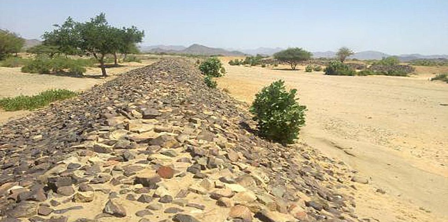
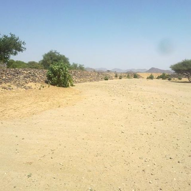
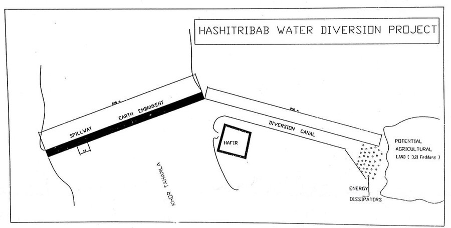
Water Spreading from khors or wadis where channelized runoff/ floodwater is diverted onto plains which are then cultivated on residual moisture. An example of a scheme which was constructed in 1999 is located at Hashitribab, some 7 km from Sinkat on the road towards Kassala. This scheme, comprising a stone-pitched earth diversion barrier across a khor (an ephemeral water course), is documented by using among others the WOCAT Questionnaire and WOCAT’s QA. While the diversion is still intact and provides water to the fields about one kilometre downstream (there were young sorghum plants growing at the time of the visit in November 2011) maintenance will be needed.
There was only a very small input of voluntary labour in its original construction (comprising a contribution in terms of stone pitching).

Construction by the Government, using machinery, with little local contribution might explain why voluntary maintenance of the structures has been negligible. Water spreading schemes have gradually expanded in number over the last 20 years in Red Sea State (according to Sayed Dabloub’s personal comment). Currently it was confirmed that there are new sites under planning and construction.

The purposes of diversion dam construction was to divert the main water course to take its way in the crop growing area replacing the old one and being controlled by small diversion dams (terraces to spread water for even water distribution through the original land. These terraces remarkably reduce gully formation.
Most important purpose is to provide water to growing crops in an area which is too dry for rain fed production and where no source for irrigation is available. It secures moisture during the growing season, by allowing more water to penetrate soil and to preserve moisture for a longer period at plant root zone.
The decrease of flood water velocity leads to silt accumulation and other debris materials which increase soil capability in providing moisture, nutrients and maintain soil structure and conservation.

For the earthen/stone-pitched diversion structure with spillway and small haffir alongside machines have been used (mainly loaders provided by the government) which excavated and built the bund. In addition local communities were involved in some aspects of the establishment (mainly stone pitching) supported/subsidized with incentives. The structure/scheme at Hashitribab (close to Sinkat) was built in 1999 (and no maintenance has been done since that time). It helps in watering about 500 feddan (c. 200 hectares) of agricultural area where water is spread by the use of small contour bunds: these were also constructed using subsidies and machines.
Terraces are usually used to control water spreading along the cropped area. Those terraces usually receive the water at low speed velocity. For that reason they are very small in size and volume. Usually they are located in very gentle and uniformed areas. The terraces can be constructed by simple hand tool and tractors accessories. But the prolonged drought makes the maintenance difficult as the dry soil is more susceptible to wind erosion and sand accumulation on both sides of the dam and the bottom of the bund is one of several desertification phenomenon in the region. But the wind-blown sand is one of the most serious one especially in the dry lands of the Red Sea State. Contour survey for land leveling slope identification and location is an important step before implementation.

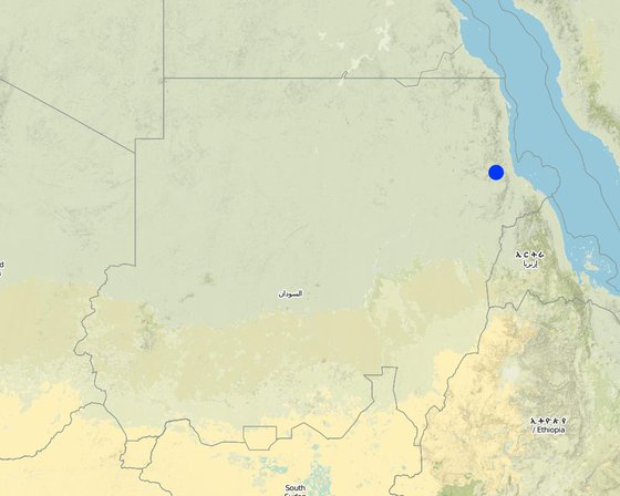
The study site is located in the arid region of Red Sea State where steep hills from north-south inland mountains are interrupted by arid plains. The population density is low and the population depends on both cropping and livestock with high incidence of poverty. For this reason there should be a clear plan for construction and community extension approach to care about the maintenance of the technology. About 120 families live in Hashitribab area. All the year round they secure their provision by storing food crops in particular sorghum.

ទីតាំង

ទីតាំង: Sinkat Locality, Red Sea, ប្រទេសស៊ូដង់

ចំនួនទីកន្លែងបច្ចេកទេស ដែលវិភាគ:

ចំណុចយោងភូមិសាស្ត្រនៃទីតាំងជ្រើសរើស
  • 36.7805, 18.8765

ការសាយភាយនៃបច្ចេកទេស: ត្រូវបានផ្សព្វផ្សាយត្រឹមតំបន់មួយ (approx. 1-10 គម2)

តើស្ថិតក្នុងតំបន់ការពារអចិន្ត្រៃយ៍?:

កាលបរិច្ឆេទនៃការអនុវត្ត: 10-50 ឆ្នាំ

ប្រភេទនៃការណែនាំឱ្យអនុវត្តន៍៖
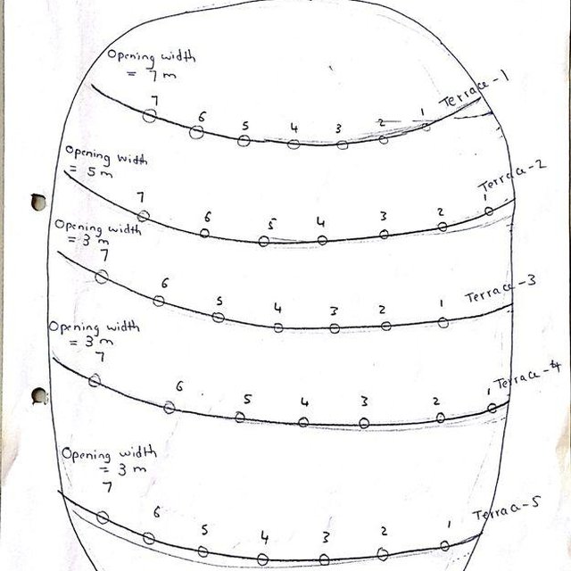
Contour Terraces System (Dr. Adil Khidir, Consultant (Khartoum))
Diversion dam and channal (Abdalla Osman Eisa (Soil Conservaton and Land Use Admin. Port sudan, Sudan.))

ចំណាត់ថ្នាក់នៃបច្ចេកទេស

គោលបំណងចម្បងៗ
  • ធ្វើឱ្យប្រសើរឡើងនូវផលិតកម្ម
  • កាត់បន្ថយ, បង្ការ, ស្តារឡើងវិញនូវការធ្លាក់ចុះគុណភាពដី
  • អភិរក្សប្រព័ន្ធអេកូឡូស៊ី
  • ការពារតំបន់ទីជម្រាល/តំបន់ខ្សែទឹកខាងក្រោមបញ្ចូលជាមួយបច្ចេកទេសផ្សេងទៀត
  • អភិរក្ស/ធ្វើឱ្យប្រសើរឡើងជីវចម្រុះ
  • កាត់បន្ថយហានិភ័យនៃគ្រោះមហន្តរាយ
  • បន្ស៊ាំទៅនឹងការប្រែប្រួលអាកាសធាតុ/គ្រោះមហន្តរាយ និងផលប៉ះពាល់របស់វា
  • កាត់បន្ថយការប្រែប្រួលអាកាសធាតុ និងផលប៉ះពាល់របស់វា
  • បង្កើតផលប្រយោជន៍សេដ្ឋកិច្ច
  • បង្កើតផលប្រយោជន៍សង្គម
ការប្រើប្រាស់ដី

  • ដីដាំដំណាំ
    • ដំណាំប្រចាំឆ្នាំ: ធញ្ញជាតិ - ពោតសាលី
    ចំនួនសារដែលដាំដំណាំក្នុងមួយឆ្នាំ: 1

ការផ្គត់ផ្គង់ទឹក
  • ទឹកភ្លៀង
  • ទឹកភ្លៀង និងប្រព័ន្ធស្រោចស្រព
  • ប្រព័ន្ធស្រោចស្រពទាំងស្រុង
  • post-flooding

គោលបំណងទាក់ទងនឹងការធ្លាក់ចុះគុណភាពដី
  • ការការពារការធ្លាក់ចុះគុណភាពដី
  • ការកាត់បន្ថយការធ្លាក់ចុះគុណភាពដី
  • ការជួសជុល/ ស្តារឡើងវិញនៃឱនភាពដីធ្ងន់ធ្ងរ
  • ការបន្ស៊ាំទៅនឹងការធ្លាក់ចុះគុណភាពដី
  • ដែលមិនអាចអនុវត្តបាន
ប្រភេទនៃការធ្លាក់ចុះគុណភាពដីដែលបានដោះស្រាយ
  • ការហូរច្រោះដីដោយសារទឹក - Wt: ការបាត់ដីស្រទាប់លើដោយការហូរច្រោះ, Wg: ការកកើតឡើងនូវកំទេចកំទីដីស្រទាប់ក្រោម, Wo: ផលប៉ះពាល់នៃការធ្លាក់ចុះគុណភាពកន្លែងឆ្ងាយ
ក្រុម SLM
  • វិធានការអនុវត្តកាត់ទទឹងទីជម្រាល
  • ការបែងចែកទឹក និងប្រព័ន្ធបង្ហូរ
វិធានការ SLM
  • វិធានការរចនាស័ម្ពន្ធ - S2: ភ្លឺ ច្រាំង

គំនូរបច្ចេកទេស

លក្ខណៈបច្ចេកទេស
None
Author: Dr. Adil Khidir, Fuculty of Engineering, Kartoum University

ការបង្កើតនិងការថែទាំ៖​ សកម្មភាព ធាតុចូល និងថ្លៃដើម

ការគណនាធាតុចូល​ និងថ្លៃដើម
  • ថ្លៃដើមត្រូវបានគណនា៖
  • រូបិយប័ណ្ណសម្រាប់ការគណនាថ្លៃដើម៖ មិនមាន
  • អត្រាប្តូរប្រាក់ (ទៅជាដុល្លារអាមេរិក)៖ 1 USD = មិនមាន
  • ថ្លៃឈ្នួលជាមធ្យមក្នុង ១ ថ្ងៃ៖ មិនមាន
កត្តាសំខាន់បំផុតដែលមានឥទ្ធិពលលើថ្លៃដើម
The slope and depth of the wadi/ khor to be diverted
សកម្មភាពបង្កើតបច្ចេកទេស
  1. Excavation of foundation trenches. (ពេលវេលា/ ភាពញឹកញាប់: 1 week)
  2. Backfilling with heavy soil (ពេលវេលា/ ភាពញឹកញាប់: 1 day)
  3. Establishment diversion structure (ពេលវេលា/ ភាពញឹកញាប់: 8 weeks)
  4. Stonepitching by hand (ពេលវេលា/ ភាពញឹកញាប់: 3 weeks)
  5. Construction of spillway (ពេលវេលា/ ភាពញឹកញាប់: 2 weeks)
ធាតុចូល និងថ្លៃដើមសម្រាប់ការបង្កើតបច្ចេកទេស
បញ្ជាក់ពីធាតុចូល ឯកតា បរិមាណ ថ្លៃដើមក្នុងមួយឯកតា (មិនមាន) ថ្លៃធាតុចូលសរុប (មិនមាន) % នៃថ្លៃដើមដែលចំណាយដោយអ្នកប្រើប្រាស់ដី
កម្លាំងពលកម្ម
labour ha 1,0 57,0 57,0
សម្ភារៈ
machine use ha 1,0 355,0 355,0
ថ្លៃដើមសរុបក្នុងការបង្កើតបច្ចេកទេស 412.0
ថ្លៃដើមសរុបក្នុងការបង្កើតបច្ចេកទេសគិតជាដុល្លារ 412.0
សកម្មភាពថែទាំ
  1. Tillage (ពេលវេលា/ ភាពញឹកញាប់: before fluding period)

បរិស្ថានធម្មជាតិ

បរិមាណទឹកភ្លៀងជាមធ្យមប្រចាំឆ្នាំ
  • < 250 មម
  • 251-500 មម
  • 501-750 មម
  • 751-1,000 មម
  • 1,001-1,500 មម
  • 1,501-2,000 មម
  • 2,001-3,000 មម
  • 3,001-4,000 មម
  • > 4,000 មម
តំបន់កសិអាកាសធាតុ
  • សើម
  • មានភ្លៀងមធ្យម
  • មានភ្លៀងតិចតួច
  • ស្ងួត
លក្ខណៈសម្គាល់នៃអាកាសធាតុ
Thermal climate class: tropics
ជម្រាល
  • រាបស្មើ (0-2%)
  • ជម្រាលតិចតួច (3-5%)
  • មធ្យម (6-10%)
  • ជម្រាលខ្ពស់បន្តិច (11-15%)
  • ទីទួល (16-30%)
  • ទីទួលចោត (31-60%)
  • ទីទួលចោតខ្លាំង (>60%)
ទម្រង់ដី
  • ខ្ពង់រាប
  • កំពូលភ្នំ
  • ជម្រាលភ្នំ
  • ជម្រាលទួល
  • ជម្រាលជើងភ្នំ
  • បាតជ្រលងភ្នំ
រយៈកម្ពស់ធៀបនឹងនីវ៉ូទឹកសមុទ្រ
  • 0-100 ម​
  • 101-500 ម
  • 501-1,000 ម
  • 1,001-1,500 ម
  • 1,501-2,000 ម
  • 2,001-2,500 ម
  • 2,501-3,000 ម
  • 3,001-4,000 ម
  • > 4,000 ម
បច្ចេកទេសត្រូវបានអនុវត្តនៅក្នុង
  • សណ្ឋានដីប៉ោង
  • សណ្ឋានដីផត
  • មិនពាក់ព័ន្ធទាំងអស់
ជម្រៅដី
  • រាក់ខ្លាំង (0-20 សម)
  • រាក់ (21-50 សម)
  • មធ្យម (51-80 សម)
  • ជ្រៅ (81-120 សម)
  • ជ្រៅខ្លាំង (> 120 សម)
វាយនៈភាពដី (ដីស្រទាប់ខាងលើ)
  • គ្រើម/ មានពន្លឺ (ខ្សាច់)
  • មធ្យម (ល្បាយ, ល្បាប់)
  • ម៉ត់/ ធ្ងន់ (ឥដ្ឋ)
វាយនភាពដី (>​ 20 សម ក្រោមស្រទាប់លើ)
  • គ្រើម/ មានពន្លឺ (ខ្សាច់)
  • មធ្យម (ល្បាយ, ល្បាប់)
  • ម៉ត់/ ធ្ងន់ (ឥដ្ឋ)
កម្រិតសារធាតុសរីរាង្គក្នុងដី​​ស្រទាប់លើ
  • ខ្ពស់ (>3%)
  • មធ្យម (1-3%)
  • ទាប (<1%)
ដង្ហើមទឹកក្នុងដី
  • ផ្ទៃខាងលើ
  • < 5 ម
  • 5-50 ម
  • > 50 ម
ភាពអាចរកបាននៃទឹកលើដី
  • លើស
  • ល្អ
  • កម្រិតមធ្យម
  • មិនមាន/ គ្មាន
គុណភាពទឹក (មិនបានធ្វើប្រព្រឹត្តិកម្ម)
  • ទឹកពិសារដែលមានគុណភាពល្អ
  • ទឹកពិសារដែលគ្មានគុណភាព (តម្រូវឱ្យមានការសំអាត)
  • ទឹកសម្រាប់តែការធ្វើកសិកម្ម (ស្រោចស្រព)
  • ទឹកមិនអាចប្រើប្រាស់បាន
គុណភាពទឹក គឺផ្តោតទៅលើ៖
តើមានបញ្ហាទឹកប្រៃហូរចូល​​ដែរឬទេ?
  • បាទ/ចា៎
  • ទេ

ការកើតឡើងនៃទឹកជំនន់
  • បាទ/ចា៎
  • ទេ
ភាពសំបូរបែបនៃប្រភេទសត្វ
  • ខ្ពស់
  • កម្រិតមធ្យម
  • ទាប
ភាពសំបូរបែបនៃជម្រកធម្មជាតិ
  • ខ្ពស់
  • កម្រិតមធ្យម
  • ទាប

ចរិតលក្ខណៈរបស់អ្នកប្រើប្រាស់ដីដែលប្រើបច្ចេកទេស SLM

ទីផ្សារ
  • សម្រាប់ហូបក្នុងគ្រួសារ (ផ្គត់ផ្គង់ខ្លួនឯង)
  • ពាក់កណ្តាលពាណិជ្ជកម្ម (ផ្គត់ផ្គង់ខ្លួនឯង/ ពាណិជ្ជកម្ម)
  • ពាណិជ្ជកម្ម/ ទីផ្សារ
ចំណូលក្រៅកសិដ្ឋាន
  • តិចជាង 10% នៃចំណូល
  • 10-50% នៃចំណូល
  • ច្រើនជាង 50% នៃចំណូល
កម្រិតជីវភាព
  • មិនល្អខ្លាំង
  • មិនល្អ
  • មធ្យម
  • មាន
  • មានខ្លាំង
កម្រិតនៃការប្រើគ្រឿងយន្ត
  • ប្រើកម្លាំងពលកម្ម
  • ប្រើកម្លាំងសត្វ
  • គ្រឿងយន្ត/ ម៉ាស៊ីន
នៅមួយកន្លែង ឬពនេចរ
  • នៅមួយកន្លែង
  • ពាក់កណ្តាលពនេចរ
  • ពនេចរ
បុគ្គល ឬក្រុម
  • ធ្វើខ្លួនឯង/ គ្រួសារ
  • ជាក្រុម/ សហគមន៍
  • សហករ
  • មានបុគ្គលិក (ក្រុមហ៊ុន, រដ្ឋ)
យេនឌ័រ
  • ស្ត្រី
  • បុរស
អាយុ
  • កុមារ
  • យុវវ័យ
  • វ័យកណ្តាល
  • មនុស្សចាស់
ផ្ទៃដីប្រើប្រាស់ក្នុងមួយគ្រួសារ
  • < 0.5 ហិកតា
  • 0.5-1 ហិកតា
  • 1-2 ហិកតា
  • 2-5 ហិកតា
  • 5-15 ហិកតា
  • 15-50 ហិកតា
  • 50-100 ហិកតា
  • 100-500 ហិកតា
  • 500-1,000 ហិកតា
  • 1,000-10,000 ហិកតា
  • > 10,000 ហិកតា
មាត្រដ្ឋាន
  • ខ្នាតតូច
  • ខ្នាតមធ្យម
  • ខ្នាតធំ
ភាពជាម្ចាស់ដីធ្លី
  • រដ្ឋ
  • ក្រុមហ៊ុន
  • ភូមិ
  • ក្រុម
  • ឯកជន មិនមានកម្មសិទ្ធ
  • ឯកជន មានកម្មសិទ្ធ
សិទ្ធិប្រើប្រាស់ដី
  • អាស្រ័យផលសេរី (មិនមានការកំណត់)
  • ជាក្រុម (មានដែនកំណត់)
  • កិច្ចសន្យាជួល
  • ឯកជន
សិទ្ធិប្រើប្រាស់ទឹក
  • អាស្រ័យផលសេរី (មិនមានការកំណត់)
  • ជាក្រុម (មានដែនកំណត់)
  • កិច្ចសន្យាជួល
  • ឯកជន
ប្រើប្រាស់សេវាកម្ម និងហេដ្ឋារចនាសម្ព័ន្ធ
សុខភាព

មិនល្អ
ល្អ
ការអប់រំ

មិនល្អ
ល្អ
ជំនួយបច្ចេកទេស

មិនល្អ
ល្អ
ការងារ (ឧ. ការងារក្រៅកសិដ្ឋាន)

មិនល្អ
ល្អ
ទីផ្សារ

មិនល្អ
ល្អ
ថាមពល

មិនល្អ
ល្អ
ផ្លូវ និងការដឹកជញ្ជូន

មិនល្អ
ល្អ
ទឹកផឹក និងអនាម័យ

មិនល្អ
ល្អ

ផលប៉ះពាល់

ផលប៉ះពាល់សេដ្ឋកិច្ចសង្គម
ផលិតកម្មដំណាំ
ថយចុះ
កើនឡើង


Relative to nothing otherwise

ផលិតកម្មចំណីសត្វ
ថយចុះ
កើនឡើង

ហានិភ័យនៃភាពបរាជ័យរបស់​​ផលិតកម្ម
កើនឡើង
ថយចុះ

ទំហំផ្ទៃដីផលិតកម្ម (ដីថ្មីដែលបានដាំដុះ/ ប្រើប្រាស់)
ថយចុះ
កើនឡើង

ទឹកបរិភោគដែលអាចទាញយកមកប្រើប្រាស់បាន
ថយចុះ
កើនឡើង

ចំណូលក្នុងកសិដ្ឋាន
ថយចុះ
កើនឡើង

ភាពសម្បូរបែបប្រភពប្រាក់​ចំណូល
ថយចុះ
កើនឡើង

ផលប៉ះពាល់វប្បធម៌សង្គម
សន្តិសុខស្បៀង/ ភាពគ្រប់គ្រាន់ខ្លួនឯង
កាត់បន្ថយ
ប្រសើរជាងមុន

ឱកាសវប្បធម៌ (ឧ. វិញ្ញាណ សាភ័ណភាព ផ្សេងទៀត)
កាត់បន្ថយ
ប្រសើរជាងមុន

ឱកាសនៃការបង្កើតថ្មី
កាត់បន្ថយ
ប្រសើរជាងមុន

ស្ថាប័នសហគមន៍
ភាពខ្សោយ
ភាពខ្លាំង

competition with natural ecosystem
increased
decreased


Floodwaters diverted will not reach original destination and those former beneficiaries

contribution to human well-being
decreased
increased


Due to more reliable production despite low and variable rainfall

ផលប៉ះពាល់លើអេកូឡូស៊ី
បរិមាណទឹក
ថយចុះ
កើនឡើង

គុណភាពទឹក
ថយចុះ
កើនឡើង

ការប្រមូលទឹក (លំហូរ ទឹកសន្សើម ព្រិល ។ល។)
កាត់បន្ថយ
ប្រសើរជាងមុន

លំហូរទឹកលើផ្ទៃដី
កើនឡើង
ថយចុះ

រំហួត
កើនឡើង
ថយចុះ

សំណើមដី
ថយចុះ
កើនឡើង

គម្របដី
កាត់បន្ថយ
ប្រសើរជាងមុន

សារធាតុសរីរាង្គដី/ការបូនក្រោមដី
ថយចុះ
កើនឡើង

competition with natural ecosystem
increased
decreased


Floodwaters diverted will not reach original destination

ផលប៉ះពាល់ក្នុងបរិវេណ
ទឹកដែលអាចទាញមកប្រើប្រាស់បាន (ទឹកក្រោមដី ទឹក-springs)
ថយចុះ
កើនឡើង

ទឹកជំនន់ខ្សែទឹកខាងក្រោម (មិនត្រូវការ)
កើនឡើង
កាត់បន្ថយ

ការវិភាគថ្លៃដើម និងអត្ថប្រយោជន៍

អត្ថប្រយោជន៍បើប្រៀបធៀបនឹងថ្លៃដើមក្នុងការបង្កើតបច្ចេកទេស
រយៈពេលខ្លី
អវិជ្ជមានខ្លាំង
វិជ្ជមានខ្លាំង

រយៈពេលវែង
អវិជ្ជមានខ្លាំង
វិជ្ជមានខ្លាំង

អត្ថប្រយោជន៍បើប្រៀបធៀបនឹងថ្លៃដើមក្នុងការថែទាំបច្ចេកទេស
no maintenance carried out so not applicable here

ការប្រែប្រួលអាកាសធាតុ

ការប្រែប្រួលអាកាសធាតុ
សីតុណ្ហភាពប្រចាំឆ្នាំ កើនឡើង

មិនល្អ
ល្អណាស់
គ្រោះអាកាសធាតុ (មហន្តរាយ) ​
ទឹកជំនន់ទូទៅ (ទន្លេ)

មិនល្អ
ល្អណាស់

ការទទួលយក និងការបន្ស៊ាំ

ភាគរយនៃអ្នកប្រើប្រាស់ដីនៅតំបន់ដែលបានទទួលយកបច្ចេកទេស
  • តែមួយករណី /ពិសោធន៍
  • 1-10%
  • 11-50%
  • > 50%
ក្នុងចំណោមអ្នកទទួលយកបច្ចេកទេសនេះ តើមាន​ប៉ុន្មាន​ភាគរយ​ដែល​បាន​អនុវត្តន៍​ដោយ​មិន​បាន​ទទួលការលើក​ទឹកចិត្ត​ជាសម្ភារៈ?
  • 0-10%
  • 11-50%
  • 51-90%
  • 91-100%
តើថ្មីៗនេះ បច្ចេកទេសនេះត្រូវបានកែតម្រូវ​ដើម្បី​បន្ស៊ាំ​ទៅនឹង​ស្ថាន​ភាព​ប្រែប្រួល​ដែរ​ឬទេ?
  • បាទ/ចា៎
  • ទេ
ចំពោះលក្ខខណ្ឌប្រែប្រួលណាមួយដែលត្រូវបានបន្ស៊ាំ?
  • ការប្រែប្រួលអាកាសធាតុ/គ្រោះមហន្តរាយធម្មជាតិ
  • បម្រែបម្រួលទីផ្សារ
  • កម្លាំងពលកម្មដែលអាចរកបាន (ចំណាកស្រុក)

សេក្តីសន្និដ្ឋាន និងមេរៀនបទពិសោធន៍

ភាពខ្លាំង: ទស្សនៈអ្នកប្រើប្រាស់ដី
ភាពខ្លាំង: ទស្សនៈរបស់អ្នកចងក្រង ឬបុគ្គលសំខាន់ផ្សេងទៀត
  • Useful and important in the area where floodwater harvesting/ spate irrigation is the only option for crop production. No rain fed irrigation system on the Red Sea State unlike to other Sudan.
ចំណុចខ្សោយ/ គុណវិបត្តិ/ ហានិភ័យ​ : ទស្សនៈអ្នកប្រើប្រាស់ដីវិធីដោះស្រាយ
  • SLM not falls under the community responsibility. They believe SLM is completely Gos role. Land users awareness and involvement
  • They don’t think that community plays a role in the ongoing soil and vegetation degradation Rotational grazing and seed broadcasting
  • They also say no regular concern by the government is given in relation to land reclamation A location of budget and equipment to reclaim land and natural vegetation conservation.
  • They confirm that the physical conditions played a great role in land degradation e.g. drought aridity and high temperatures . To ensure water harvesting and without waste.
ចំណុចខ្សោយ/ គុណវិបត្តិ/ ហានិភ័យ​ : ទស្សនៈរបស់អ្នកចងក្រង ឬបុគ្គលសំខាន់ផ្សេងទៀតវិធីដោះស្រាយ
  • High cost (needs machinery to move earth) More support from Government and outside
  • Not enough trained personnel More up-grading skills are required
  • Very little data available (apart from construction details) Better system of monitoring and evaluation
  • Low technical capacity of the community Capacity building and training

ឯកសារយោង

អ្នកចងក្រង
  • Abdalla Osman Eisa
Editors
អ្នកត្រួតពិនិត្យ
  • Deborah Niggli
  • Alexandra Gavilano
កាលបរិច្ឆេទនៃការអនុវត្ត: 22 ខែ មេសា ឆ្នាំ 2015
កែតម្រូវចុងក្រោយ: 14 ខែ សីហា ឆ្នាំ 2019
បុគ្គលសំខាន់ៗ
ការពណ៌នាលម្អិតក្នុងប្រព័ន្ធគ្រប់គ្រងទិន្នន័យរបស់វ៉ូខេត
ទិន្នន័យ SLM ភ្ជាប់ជាមួយ
ឯកសារនេះត្រូវបានសម្របសម្រួលដោយ
ស្ថាប័ន៖ គម្រោង
This work is licensed under Creative Commons Attribution-NonCommercial-ShareaAlike 4.0 International