Rehabilitated gully with a check dam and tree planting (Mia Jan Maroofi)

Gully treatment (ប្រទេសអាហ្វហ្គានិស្ថាន)

Check dam

ការពណ៌នា

Small check dams made of stone, together with planting of trees, slow water flow and reduce further erosion in a gully, leading to its restoration.

Project supported implementation of gully treatment has taken place in the villages Sari Joy and Jawaz Khana, located in Chokar watershed of Rustaq District in Northern Afghanistan. The Chokar watershed is a mountainous area situated between 600 m and 2,500 m above sea level. The climate is semi-arid with harsh and cold weather in winter and hot and dry summers. The annual precipitation in average years is 580 mm. Land degradation affects all forms of land use and includes sparse vegetation cover, severe topsoil erosion from water, and poor soil fertility. Unsustainable agricultural practices, together with over-exploitation and high pressure on the natural resources, are adversely impacting the socio-economic well-being of local communities, as well as contributing to the risk of being adversely affected by drought, and also leading to landslides and flash foods triggered by heavy rainfall. The data used for the documentation of the technology are based on field research conducted in Chokar watershed, namely in the villages of Sari Joy and Jawaz Khana. These villages represent the upper and the middle zone of Chokar watershed, respectively. They differ considerably in access to services and infrastructure, but in general are poorly served. The communities depend on land resources for sustaining their livelihoods. In a good year with high yields, wheat self-sufficiency lasts about 5 months. The villages are home to ethnic Qarluq communities. Since 2012 the Livelihood Improvement Project Takhar (LIPT) implemented by Terre des hommes (Tdh) Switzerland has initiated a range of NRM interventions.

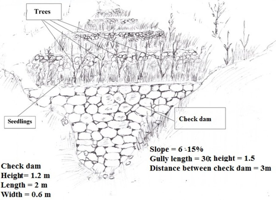
The Livelihood Improvement Project in Takhar supported Natural Resources Management Committees to rehabilitate two gullies with check dams and trees in Sari Joy and Jawaz Khana. The check dams are made of stone walls built across the widest section of the gully. Jute bags filled with soil are used in the narrower sections of the gully to form a solid barrier for soil to accumulate. Tree seedlings and cuttings of Russian willow and acacia are planted between the check dams to stabilize the soil. During the first 2-3 years, the trees need to be protected from grazing, and from cutting for fuelwood. Watering of the trees may also be required during the dry season, especially in Jawaz Khana, to support their survival. Such methods of gully rehabilitation are feasible in the area, since the construction and planting materials are locally available. However, the costs for establishing the check dams remain relatively high and the local villages have contributed mainly with labour inputs, while the costs for construction material were provided by the project.

Check dams inside the gully slow the water flow and help its infiltration into the soil. The structures also collect sediment and reduce further erosion of the gully bed, and prevent its expansion in the area. Well managed check dams, after several years, can produce trees for fuelwood and grass for animal fodder.

Rehabilitation of gullies is an innovative practice for the local land users, but it is supported by the local communities for its visible impact on preventing further erosion and loss of community land used for crop cultivation, forest and orchards. After taking part in the design and implementation of rehabilitation activities, the local land users expressed that they had acquired useful skills and will be able to conduct these works independently if the material resources are available.

Women support the work by preparing and bringing food to the workers in the field. Women are also occasionally involved in filling the jute bags with soil and bring the bags to the gully. This requires significant inputs, bearing in mind that gullies are often formed in very steep areas where there are no roads - and thus the food and other material can be delivered only by foot or with a donkey.

ទីតាំង

ទីតាំង: Sari Joy and Jawaz Khana Villages, Takhar Province, Rustaq District, ប្រទេសអាហ្វហ្គានិស្ថាន

ចំនួនទីកន្លែងបច្ចេកទេស ដែលវិភាគ: 2-10 កន្លែង

ចំណុចយោងភូមិសាស្ត្រនៃទីតាំងជ្រើសរើស
  • 69.80473, 36.96769

ការសាយភាយនៃបច្ចេកទេស: អនុវត្តនៅកន្លែងជាក់លាក់មួយ/ ប្រមូលផ្តុំនៅតំបន់តូចៗ

កាលបរិច្ឆេទនៃការអនុវត្ត: តិចជាង 10ឆ្នាំមុន (ថ្មី)

ប្រភេទនៃការណែនាំឱ្យអនុវត្តន៍៖
Check dam in a gully (Reto Zender)

ចំណាត់ថ្នាក់នៃបច្ចេកទេស

គោលបំណងចម្បងៗ
  • ធ្វើឱ្យប្រសើរឡើងនូវផលិតកម្ម
  • កាត់បន្ថយ, បង្ការ, ស្តារឡើងវិញនូវការធ្លាក់ចុះគុណភាពដី
  • អភិរក្សប្រព័ន្ធអេកូឡូស៊ី
  • ការពារតំបន់ទីជម្រាល/តំបន់ខ្សែទឹកខាងក្រោមបញ្ចូលជាមួយបច្ចេកទេសផ្សេងទៀត
  • អភិរក្ស/ធ្វើឱ្យប្រសើរឡើងជីវចម្រុះ
  • កាត់បន្ថយហានិភ័យនៃគ្រោះមហន្តរាយ
  • បន្ស៊ាំទៅនឹងការប្រែប្រួលអាកាសធាតុ/គ្រោះមហន្តរាយ និងផលប៉ះពាល់របស់វា
  • កាត់បន្ថយការប្រែប្រួលអាកាសធាតុ និងផលប៉ះពាល់របស់វា
  • បង្កើតផលប្រយោជន៍សេដ្ឋកិច្ច
  • បង្កើតផលប្រយោជន៍សង្គម
ការប្រើប្រាស់ដី

  • ដីដាំដំណាំ - ដំណាំប្រចាំឆ្នាំ, ដំណាំរយៈពេលវែង (មិនមែនឈើ)
  • ចម្រុះ (ដំណាំ/ វាលស្មៅ/ ដើមឈើ)គិតទាំងកសិរុក្ខកម្ម - កសិរុក្ខកម្ម, ដីព្រៃឈើ និងដីចិញ្ចឹមសត្វ

ការផ្គត់ផ្គង់ទឹក
  • ទឹកភ្លៀង
  • ទឹកភ្លៀង និងប្រព័ន្ធស្រោចស្រព
  • ប្រព័ន្ធស្រោចស្រពទាំងស្រុង

ចំនួនរដូវដាំដុះក្នុងមួយឆ្នាំ: 1
ការប្រើប្រាស់ដីមុនពេលអនុវត្តបច្ចេកទេស: មិនមាន
ដង់ស៊ីតេនៃសត្វចិញ្ចឹម: មិនមាន

គោលបំណងទាក់ទងនឹងការធ្លាក់ចុះគុណភាពដី
  • ការការពារការធ្លាក់ចុះគុណភាពដី
  • ការកាត់បន្ថយការធ្លាក់ចុះគុណភាពដី
  • ការជួសជុល/ ស្តារឡើងវិញនៃឱនភាពដីធ្ងន់ធ្ងរ
  • ការបន្ស៊ាំទៅនឹងការធ្លាក់ចុះគុណភាពដី
  • ដែលមិនអាចអនុវត្តបាន
ប្រភេទនៃការធ្លាក់ចុះគុណភាពដីដែលបានដោះស្រាយ
  • ការហូរច្រោះដីដោយសារទឹក - Wt: ការបាត់ដីស្រទាប់លើដោយការហូរច្រោះ, Wg: ការកកើតឡើងនូវកំទេចកំទីដីស្រទាប់ក្រោម, Wm: ការបាក់ដី
ក្រុម SLM
  • វិធានការអនុវត្តកាត់ទទឹងទីជម្រាល
  • ការគ្រប់គ្រងទឹកលើដី (ទឹកធ្លាក់ ទន្លេ បឹង សមុទ្រ)
វិធានការ SLM
  • វិធានការរុក្ខជាតិ - V1: ឈើធំៗ និងដើមឈើតូចៗ
  • វិធានការរចនាស័ម្ពន្ធ - S6: ជញ្ជាំង, របាំង, របងឈើខ្ពស់ៗ

គំនូរបច្ចេកទេស

លក្ខណៈបច្ចេកទេស
អ្នកនិពន្ធ: Aslam Qadamov; Roziya Kirgizbekova
A check dam is a permanent structure across a gully. The size of the check dam and the spacing of check dams depends on the steepness of the slope and length of the gully. To rehabilitate a gully on a slope of 6 - 15 % steepness and 30 meters in length there are 10 check dams built inside the gully at a distance of 3 meters apart. The measurements of the check dam are: 1.2 m x 2 m x 0.6 m. The dam is built from stones or boulders either available locally or transported to the gully site. The upper part of the gully is planted with rows of tree cuttings (7 pieces) and saplings (3 pieces).

ការបង្កើតនិងការថែទាំ៖​ សកម្មភាព ធាតុចូល និងថ្លៃដើម

ការគណនាធាតុចូល​ និងថ្លៃដើម
  • ថ្លៃដើមត្រូវបានគណនា៖ ក្នុងឯកតាបច្ចេកទេស (ឯកត្តា៖ gully volume, length: 30 meter length, 1,5 meter depth, 6-15% slope)
  • រូបិយប័ណ្ណសម្រាប់ការគណនាថ្លៃដើម៖ ដុល្លារអាមេរិក
  • អត្រាប្តូរប្រាក់ (ទៅជាដុល្លារអាមេរិក)៖ 1 USD = 67.0
  • ថ្លៃឈ្នួលជាមធ្យមក្នុង ១ ថ្ងៃ៖ 5.2-5.3 USD
កត្តាសំខាន់បំផុតដែលមានឥទ្ធិពលលើថ្លៃដើម
Due to the remoteness of the villages where the technology has been implemented, all the inputs for establishment, such as agricultural equipment, plant material, fertilizers, construction material, etc., are purchased in Rustaq town. The expenses for traveling and delivering the inputs affect the establishment costs.
សកម្មភាពបង្កើតបច្ចេកទេស
  1. Design of the check dam (ពេលវេលា/ ភាពញឹកញាប់: Winter)
  2. Digging the gully for preparation of construction work (ពេលវេលា/ ភាពញឹកញាប់: Spring)
  3. Construction of the stone wall accross the gully (ពេលវេលា/ ភាពញឹកញាប់: Spring)
  4. Filling the upper part of the stone wall with soil (ពេលវេលា/ ភាពញឹកញាប់: Spring)
  5. Planting of tree seedlings and cuttings on upper part of the wall (ពេលវេលា/ ភាពញឹកញាប់: Spring)
ធាតុចូល និងថ្លៃដើមសម្រាប់ការបង្កើតបច្ចេកទេស
បញ្ជាក់ពីធាតុចូល ឯកតា បរិមាណ ថ្លៃដើមក្នុងមួយឯកតា (ដុល្លារអាមេរិក) ថ្លៃធាតុចូលសរុប (ដុល្លារអាមេរិក) % នៃថ្លៃដើមដែលចំណាយដោយអ្នកប្រើប្រាស់ដី
កម្លាំងពលកម្ម
Design of the check dam person-day 2,0 5,3 10,6
Digging the gully for preparation of construction work person-day 8,0 5,3 42,4
Construction of stone wall person-day 12,0 5,3 63,6
Planting of tree seedlings and cuttings person-day 2,0 5,3 10,6 100,0
សម្ភារៈ
Meter piece 1,0 2,2 2,2
Shovel piece 2,0 3,8 7,6
Axe piece 1,0 2,2 2,2
Wheelbarrow piece 1,0 38,0 38,0
Rope meter 100,0 0,07 7,0
Pick axe piece 1,0 3,0 3,0
Hammer piece 1,0 2,2 2,2
សម្ភារៈដាំដុះ
Cuttings piece 100,0 0,37 37,0 50,0
Seedlings piece 10,0 0,6 6,0 50,0
សម្ភារៈសាងសង់
Stone cubic meter 6,0 7,49 44,94
ថ្លៃដើមសរុបក្នុងការបង្កើតបច្ចេកទេស 277.34
សកម្មភាពថែទាំ
  1. Protecting the trees from animals (ពេលវេលា/ ភាពញឹកញាប់: Continious)
  2. Watering the trees (ពេលវេលា/ ភាពញឹកញាប់: During dry season)
ធាតុចូលនិងថ្លៃដើមសម្រាប់ការថែទាំ
បញ្ជាក់ពីធាតុចូល ឯកតា បរិមាណ ថ្លៃដើមក្នុងមួយឯកតា (ដុល្លារអាមេរិក) ថ្លៃធាតុចូលសរុប (ដុល្លារអាមេរិក) % នៃថ្លៃដើមដែលចំណាយដោយអ្នកប្រើប្រាស់ដី
កម្លាំងពលកម្ម
Protecting the trees from animals person day 45,0 1,3 58,5 100,0
Watering the trees person day 10,0 5,3 53,0 100,0
ថ្លៃដើមសរុបសម្រាប់ការថែទាំដំណាំតាមបច្ចេកទេស 111.5

បរិស្ថានធម្មជាតិ

បរិមាណទឹកភ្លៀងជាមធ្យមប្រចាំឆ្នាំ
  • < 250 មម
  • 251-500 មម
  • 501-750 មម
  • 751-1,000 មម
  • 1,001-1,500 មម
  • 1,501-2,000 មម
  • 2,001-3,000 មម
  • 3,001-4,000 មម
  • > 4,000 មម
តំបន់កសិអាកាសធាតុ
  • សើម
  • មានភ្លៀងមធ្យម
  • មានភ្លៀងតិចតួច
  • ស្ងួត
លក្ខណៈសម្គាល់នៃអាកាសធាតុ
បរិមាណទឹកភ្លៀងជាមធ្យមប្រចាំឆ្នាំគិតជា មម៖ 564.0
Average annual precipitation for the area is 564 mm, with minimum in dry years (e.g. 2000 and 2001) of 270 mm and maximum in wet years (e.g. 2009 and 2010) of 830 mm. The data set shows an absolute maximum for annual rainfall for 1986, 1024 mm, and the absolute minimum for 2001, 269 mm. The data series covers the period from 1979 to 2014.
ស្ថានីយឧតុនិយម៖​ Climate Forecast System Reanalysis (CFSR), http://rda.ucar.edu/pub/cfsr.html
Derived from the publicly available dataset on length of growing period (LGP) (Fischer 2009 / IIASA-FAO). Internet link: http://tiles.arcgis.com/tiles/P8Cok4qAP1sTVE59/arcgis/rest/services/Length_of_growing_period/MapServer
ជម្រាល
  • រាបស្មើ (0-2%)
  • ជម្រាលតិចតួច (3-5%)
  • មធ្យម (6-10%)
  • ជម្រាលខ្ពស់បន្តិច (11-15%)
  • ទីទួល (16-30%)
  • ទីទួលចោត (31-60%)
  • ទីទួលចោតខ្លាំង (>60%)
ទម្រង់ដី
  • ខ្ពង់រាប
  • កំពូលភ្នំ
  • ជម្រាលភ្នំ
  • ជម្រាលទួល
  • ជម្រាលជើងភ្នំ
  • បាតជ្រលងភ្នំ
រយៈកម្ពស់ធៀបនឹងនីវ៉ូទឹកសមុទ្រ
  • 0-100 ម​
  • 101-500 ម
  • 501-1,000 ម
  • 1,001-1,500 ម
  • 1,501-2,000 ម
  • 2,001-2,500 ម
  • 2,501-3,000 ម
  • 3,001-4,000 ម
  • > 4,000 ម
បច្ចេកទេសត្រូវបានអនុវត្តនៅក្នុង
  • សណ្ឋានដីប៉ោង
  • សណ្ឋានដីផត
  • មិនពាក់ព័ន្ធទាំងអស់
ជម្រៅដី
  • រាក់ខ្លាំង (0-20 សម)
  • រាក់ (21-50 សម)
  • មធ្យម (51-80 សម)
  • ជ្រៅ (81-120 សម)
  • ជ្រៅខ្លាំង (> 120 សម)
វាយនៈភាពដី (ដីស្រទាប់ខាងលើ)
  • គ្រើម/ មានពន្លឺ (ខ្សាច់)
  • មធ្យម (ល្បាយ, ល្បាប់)
  • ម៉ត់/ ធ្ងន់ (ឥដ្ឋ)
វាយនភាពដី (>​ 20 សម ក្រោមស្រទាប់លើ)
  • គ្រើម/ មានពន្លឺ (ខ្សាច់)
  • មធ្យម (ល្បាយ, ល្បាប់)
  • ម៉ត់/ ធ្ងន់ (ឥដ្ឋ)
កម្រិតសារធាតុសរីរាង្គក្នុងដី​​ស្រទាប់លើ
  • ខ្ពស់ (>3%)
  • មធ្យម (1-3%)
  • ទាប (<1%)
ដង្ហើមទឹកក្នុងដី
  • ផ្ទៃខាងលើ
  • < 5 ម
  • 5-50 ម
  • > 50 ម
ភាពអាចរកបាននៃទឹកលើដី
  • លើស
  • ល្អ
  • កម្រិតមធ្យម
  • មិនមាន/ គ្មាន
គុណភាពទឹក (មិនបានធ្វើប្រព្រឹត្តិកម្ម)
  • ទឹកពិសារដែលមានគុណភាពល្អ
  • ទឹកពិសារដែលគ្មានគុណភាព (តម្រូវឱ្យមានការសំអាត)
  • ទឹកសម្រាប់តែការធ្វើកសិកម្ម (ស្រោចស្រព)
  • ទឹកមិនអាចប្រើប្រាស់បាន
តើមានបញ្ហាទឹកប្រៃហូរចូល​​ដែរឬទេ?
  • បាទ/ចា៎
  • ទេ

ការកើតឡើងនៃទឹកជំនន់
  • បាទ/ចា៎
  • ទេ
ភាពសំបូរបែបនៃប្រភេទសត្វ
  • ខ្ពស់
  • កម្រិតមធ្យម
  • ទាប
ភាពសំបូរបែបនៃជម្រកធម្មជាតិ
  • ខ្ពស់
  • កម្រិតមធ្យម
  • ទាប

ចរិតលក្ខណៈរបស់អ្នកប្រើប្រាស់ដីដែលប្រើបច្ចេកទេស SLM

ទីផ្សារ
  • សម្រាប់ហូបក្នុងគ្រួសារ (ផ្គត់ផ្គង់ខ្លួនឯង)
  • ពាក់កណ្តាលពាណិជ្ជកម្ម (ផ្គត់ផ្គង់ខ្លួនឯង/ ពាណិជ្ជកម្ម
  • ពាណិជ្ជកម្ម/ ទីផ្សារ
ចំណូលក្រៅកសិដ្ឋាន
  • តិចជាង 10% នៃចំណូល
  • 10-50% នៃចំណូល
  • ច្រើនជាង 50% នៃចំណូល
កម្រិតជីវភាព
  • មិនល្អខ្លាំង
  • មិនល្អ
  • មធ្យម
  • មាន
  • មានខ្លាំង
កម្រិតនៃការប្រើគ្រឿងយន្ត
  • ប្រើកម្លាំងពលកម្ម
  • ប្រើកម្លាំងសត្វ
  • គ្រឿងយន្ត/ ម៉ាស៊ីន
នៅមួយកន្លែង ឬពនេចរ
  • នៅមួយកន្លែង
  • ពាក់កណ្តាលពនេចរ
  • ពនេចរ
បុគ្គល ឬក្រុម
  • ធ្វើខ្លួនឯង/ គ្រួសារ
  • ជាក្រុម/ សហគមន៍
  • សហករ
  • មានបុគ្គលិក (ក្រុមហ៊ុន, រដ្ឋ)
យេនឌ័រ
  • ស្ត្រី
  • បុរស
អាយុ
  • កុមារ
  • យុវវ័យ
  • វ័យកណ្តាល
  • មនុស្សចាស់
ផ្ទៃដីប្រើប្រាស់ក្នុងមួយគ្រួសារ
  • < 0.5 ហិកតា
  • 0.5-1 ហិកតា
  • 1-2 ហិកតា
  • 2-5 ហិកតា
  • 5-15 ហិកតា
  • 15-50 ហិកតា
  • 50-100 ហិកតា
  • 100-500 ហិកតា
  • 500-1,000 ហិកតា
  • 1,000-10,000 ហិកតា
  • > 10,000 ហិកតា
មាត្រដ្ឋាន
  • ខ្នាតតូច
  • ខ្នាតមធ្យម
  • ខ្នាតធំ
ភាពជាម្ចាស់ដីធ្លី
  • រដ្ឋ
  • ក្រុមហ៊ុន
  • ភូមិ
  • ក្រុម
  • ឯកជន មិនមានកម្មសិទ្ធ
  • ឯកជន មានកម្មសិទ្ធ
សិទ្ធិប្រើប្រាស់ដី
  • អាស្រ័យផលសេរី (មិនមានការកំណត់)
  • ជាក្រុម (មានដែនកំណត់)
  • កិច្ចសន្យាជួល
  • ឯកជន
សិទ្ធិប្រើប្រាស់ទឹក
  • អាស្រ័យផលសេរី (មិនមានការកំណត់)
  • ជាក្រុម (មានដែនកំណត់)
  • កិច្ចសន្យាជួល
  • ឯកជន
ប្រើប្រាស់សេវាកម្ម និងហេដ្ឋារចនាសម្ព័ន្ធ

ផលប៉ះពាល់

ផលប៉ះពាល់សេដ្ឋកិច្ចសង្គម
ផលិតកម្មដំណាំ
ថយចុះ
កើនឡើង


Treatment of gullies on cropland, forest (mixed) land and grazing land protects the land from further erosion and protects the crop.

ផលិតកម្មចំណីសត្វ
ថយចុះ
កើនឡើង

ផលិតកម្មសត្វ
ថយចុះ
កើនឡើង

ភាពសម្បូរបែបនៃផលិតផល
ថយចុះ
កើនឡើង

ទំហំផ្ទៃដីផលិតកម្ម (ដីថ្មីដែលបានដាំដុះ/ ប្រើប្រាស់)
ថយចុះ
កើនឡើង


Through implementation of gully treatment the area that was lost to gully formation can be used for production purposes again.

ផលប៉ះពាល់វប្បធម៌សង្គម
ផលប៉ះពាល់លើអេកូឡូស៊ី
លំហូរទឹកលើផ្ទៃដី
កើនឡើង
ថយចុះ

ការបាត់បង់ដី
កើនឡើង
ថយចុះ

ដំណាំគម្របដី
ថយចុះ
កើនឡើង

ផលប៉ះពាល់ក្នុងបរិវេណ
ទឹកជំនន់ខ្សែទឹកខាងក្រោម (មិនត្រូវការ)
កើនឡើង
កាត់បន្ថយ

កំណកល្បាប់ខ្សែទឹកខាងក្រោម
កើនឡើង
ថយចុះ

សមត្ថភាពចម្រោះ (ដោយដី ដំណាំ ដីសើម)
កាត់បន្ថយ
ប្រសើរជាងមុន

ការវិភាគថ្លៃដើម និងអត្ថប្រយោជន៍

អត្ថប្រយោជន៍បើប្រៀបធៀបនឹងថ្លៃដើមក្នុងការបង្កើតបច្ចេកទេស
រយៈពេលខ្លី
អវិជ្ជមានខ្លាំង
វិជ្ជមានខ្លាំង

រយៈពេលវែង
អវិជ្ជមានខ្លាំង
វិជ្ជមានខ្លាំង

អត្ថប្រយោជន៍បើប្រៀបធៀបនឹងថ្លៃដើមក្នុងការថែទាំបច្ចេកទេស
SLM implementers from three villages were asked to jointly discuss and rate the SLM technologies short term (1-3 years) and long-term (10 years) return. As most of the technologies have only been implemented 1-2 years ago, it is too early to compare benefits to maintenance costs. Farmers have little experience so far on the actual benefits of the SLM technologies. The ratings are mostly based on expected benefits and not on actual benefits.

ការប្រែប្រួលអាកាសធាតុ

គ្រោះអាកាសធាតុ (មហន្តរាយ) ​
ព្យុះភ្លៀងតាមតំបន់

មិនល្អ
ល្អណាស់
រាំងស្ងួត

មិនល្អ
ល្អណាស់

ការទទួលយក និងការបន្ស៊ាំ

ភាគរយនៃអ្នកប្រើប្រាស់ដីនៅតំបន់ដែលបានទទួលយកបច្ចេកទេស
  • តែមួយករណី /ពិសោធន៍
  • 1-10%
  • 10-50%
  • ច្រើនជាង 50%
ក្នុងចំណោមអ្នកទទួលយកបច្ចេកទេសនេះ តើមាន​ប៉ុន្មាន​ភាគរយ​ដែល​បាន​អនុវត្តន៍​ដោយ​មិន​បាន​ទទួលការលើក​ទឹកចិត្ត​ជាសម្ភារៈ?
  • 0-10%
  • 10-50%
  • 50-90%
  • 90-100%
ចំនួនខ្នងផ្ទះ និង/ឬតំបន់ដែលគ្របដណ្តប់
2 households
តើថ្មីៗនេះ បច្ចេកទេសនេះត្រូវបានកែតម្រូវ​ដើម្បី​បន្ស៊ាំ​ទៅនឹង​ស្ថាន​ភាព​ប្រែប្រួល​ដែរ​ឬទេ?
  • បាទ/ចា៎
  • ទេ
ចំពោះលក្ខខណ្ឌប្រែប្រួលណាមួយដែលត្រូវបានបន្ស៊ាំ?
  • ការប្រែប្រួលអាកាសធាតុ/គ្រោះមហន្តរាយធម្មជាតិ
  • បម្រែបម្រួលទីផ្សារ
  • កម្លាំងពលកម្មដែលអាចរកបាន (ចំណាកស្រុក)

សេក្តីសន្និដ្ឋាន និងមេរៀនបទពិសោធន៍

ភាពខ្លាំង: ទស្សនៈអ្នកប្រើប្រាស់ដី
  • Through the technology implementation expansion of the gully is halted and loss of land is prevented.
  • The land is less vulnerable to heavy rainfall. Agricultural land, houses and local infrastructure are protected from flood damage during the rainy season.
  • The grass which grows on the rehabilitated gullies can be used for livestock fodder.
ភាពខ្លាំង: ទស្សនៈរបស់អ្នកចងក្រង ឬបុគ្គលសំខាន់ផ្សេងទៀត
  • Expansion of the production area to be used for cultivation or reforestation in a long-term perspective
ចំណុចខ្សោយ/ គុណវិបត្តិ/ ហានិភ័យ​ : ទស្សនៈអ្នកប្រើប្រាស់ដីវិធីដោះស្រាយ
  • Requires significant resources to cover all the costs for establishment
  • Establishment of check dams is highly labour intensive
ចំណុចខ្សោយ/ គុណវិបត្តិ/ ហានិភ័យ​ : ទស្សនៈរបស់អ្នកចងក្រង ឬបុគ្គលសំខាន់ផ្សេងទៀតវិធីដោះស្រាយ
  • Requires continuous maintenance to prevent damage to the constructed check dams. Protection of the trees from grazing and illegal logging is needed.
  • Technical knowledge and support is required to design and construct the gullies in accordance with local conditions and available material

ឯកសារយោង

អ្នកចងក្រង
  • Bettina Wolfgramm
Editors
  • Reto Zehnder
  • Roziya Kirgizbekova
  • Aslam Qadamov
អ្នកត្រួតពិនិត្យ
  • William Critchley
កាលបរិច្ឆេទនៃការអនុវត្ត: 13 ខែ សីហា ឆ្នាំ 2016
កែតម្រូវចុងក្រោយ: 2 ខែ វិច្ឆិកា ឆ្នាំ 2021
បុគ្គលសំខាន់ៗ
ការពណ៌នាលម្អិតក្នុងប្រព័ន្ធគ្រប់គ្រងទិន្នន័យរបស់វ៉ូខេត
ទិន្នន័យ SLM ភ្ជាប់ជាមួយ
ឯកសារនេះត្រូវបានសម្របសម្រួលដោយ
ស្ថាប័ន៖ គម្រោង
ឯកសារយោងសំខាន់ៗ
  • Guidelines for Focus Groups Discussions:
  • Methods section of the Rustaq NRM study:
This work is licensed under Creative Commons Attribution-NonCommercial-ShareaAlike 4.0 International