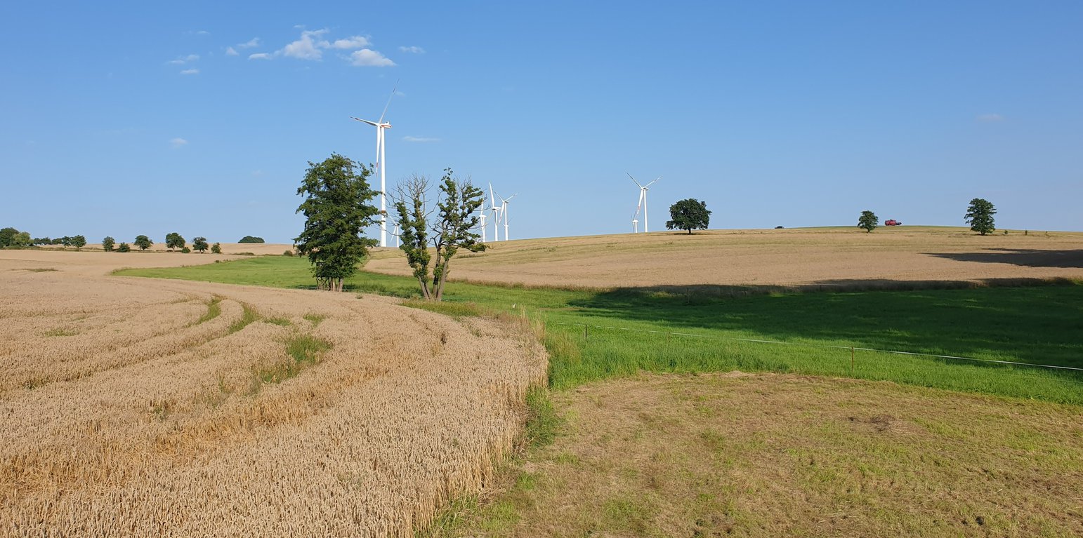
Example of a "grassed waterway" in the catchment area. (Felix Witing)

Grassed waterways (ប្រទេសអាល្លឺម៉ង់)

Dauerbegrünung erosionsgefährdeter Abflussbahnen

ការពណ៌នា

A grassed waterway is a strip of grass and other permanent low growing vegetation that is established along in the main drainage line (the thalweg) of an agricultural field to discharge water safely and prevent gully development.

In order to prevent gully erosion along main drainage lines (thalwegs), grassed waterways, composed of grass and other permanent low growing vegetation, are established to discharge water safely. The grassed waterway slows down the surface runoff in the thalweg, increases infiltration and stabilizes the soil surface. This reduces soil erosion by water and the associated runoff of nutrients and pesticides. Fiener et al. (2005) reported a sediment retention of 80-95% and a water retention of 70-90%. Sediment is trapped mainly by water infiltration (infiltration-induced sedimentation) rather than by the filtering effect of vegetation. The conservation value of grassed waterways is not as high as for other measures, but they are still considered as a biotope network as well as a habitat for grassland breeders when extensive management practices are used (LfULG, 2010).
Grassed waterways are typically installed in relatively large arable fields. Normally only the most vulnerable lowest area of the field needs to be grassed. The width of the area to be grassed depends on the size of the drained catchment, the physiographic characteristics of the discharge pathway (channel shape, bottom slope) and the land management (e.g. working width of the agricultural machinery). The United States Department of Agriculture (2020) recommends a total width of the grassed waterway of about 6 m in the upper part and 15 m in the lower part. On average, a grassed waterway should occupy 2% of the catchment area (LfULG, 2015).
During the establishment of the vegetation, it is recommended to protect and stabilize the young plants against strong water flows, by temporary measures such as silt fences or mulching. Once the vegetation is dense enough to withstand heavy rain events, these temporary measures should be removed. After each heavy rainfall event, the waterway should be inspected for damage. Damaged areas should be filled and reseeded, and sediment deposits should be removed.
The choice of the seed mixture depends on the intended use and maintenance of the grassed waterway. A combination of trees and grass increases infiltration rates and natural values. Mowing should be done at least once a year, otherwise, shrubs will establish and suppress the grass. The grassed waterway should not be used as a track for vehicles because of soil compaction, and damage to vegetation. Where possible, tillage should be across the slope – therefore perpendicular to the grassed waterway in order to avoid furrows developing parallel to the waterway. A combination with conservation tillage or other erosion control practices is highly recommended (LfULG, 2010).
Grassed waterways involve a permanent change in land-use, which means a loss of cultivable area, and associated loss of yield - and of income too if it is not covered by subsidies. Many land users dislike such structures in their fields as they impede machinery. Because land users are not always the landowners, they are not always allowed to make permanent changes in land-use. In Germany, a grassland becomes permanent after 5 years. Thus, many farmers decide to plough and replant such grassed areas every 5 years.

The landowner in our documentation had suffered from lodging of his oat crop along the drainage path due to heavy rainfall. Thus, he decided to undesow the oats with ryegrass. In the following year, the undersown ryegrass developed better than the oats and the farmer decided to establish ryegrass as the main crop over the whole field – rather then just in the thalweg, to avoid having to drive around it. Now he mows the area once in the spring for silage and then uses it as pasture for his horses. Every five years, he has to plough the whole area and replant it with ryegrass to prevent it from becoming permanent grassland.
ទីតាំង

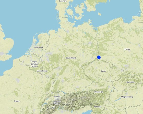
ទីតាំង: Saxony, ប្រទេសអាល្លឺម៉ង់

ចំនួនទីកន្លែងបច្ចេកទេស ដែលវិភាគ: មួយកន្លែង

ចំណុចយោងភូមិសាស្ត្រនៃទីតាំងជ្រើសរើស
  • 14.7792, 51.14017

ការសាយភាយនៃបច្ចេកទេស: អនុវត្តនៅកន្លែងជាក់លាក់មួយ/ ប្រមូលផ្តុំនៅតំបន់តូចៗ

តើស្ថិតក្នុងតំបន់ការពារអចិន្ត្រៃយ៍?: ទេ

កាលបរិច្ឆេទនៃការអនុវត្ត: 2022; តិចជាង 10ឆ្នាំមុន (ថ្មី)

ប្រភេទនៃការណែនាំឱ្យអនុវត្តន៍៖
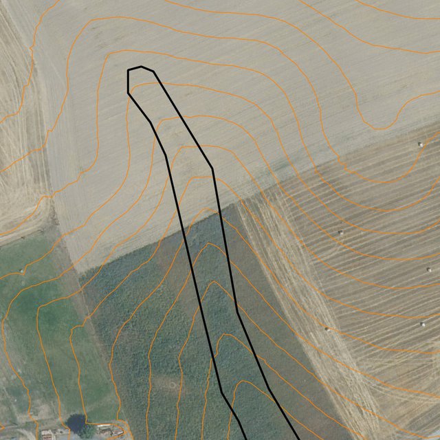
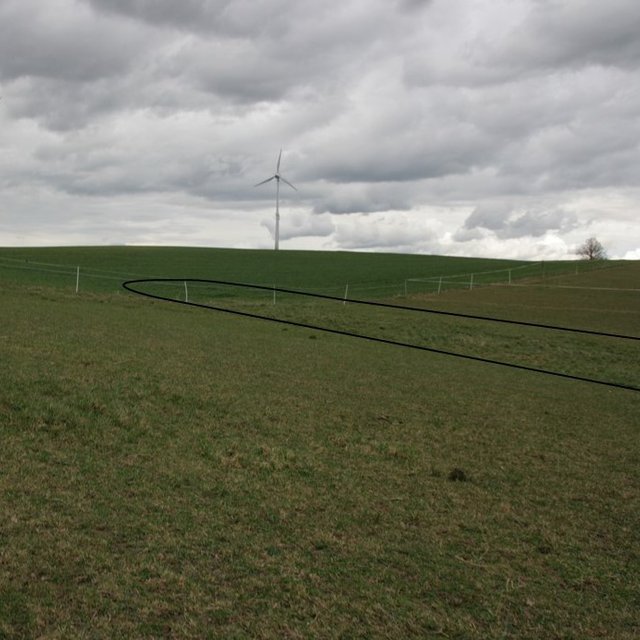
Runoff path designated by the LfULG as being particularly at risk of erosion (Data set: Map of runoff pathways that are at particular risk of erosion (vector data; Görlitz district; LfULG Saxony))
Detailed: plotted potential grassed waterway on the field (Michael Strauch)

ចំណាត់ថ្នាក់នៃបច្ចេកទេស

គោលបំណងចម្បងៗ
  • ធ្វើឱ្យប្រសើរឡើងនូវផលិតកម្ម
  • កាត់បន្ថយ, បង្ការ, ស្តារឡើងវិញនូវការធ្លាក់ចុះគុណភាពដី
  • អភិរក្សប្រព័ន្ធអេកូឡូស៊ី
  • ការពារតំបន់ទីជម្រាល/តំបន់ខ្សែទឹកខាងក្រោមបញ្ចូលជាមួយបច្ចេកទេសផ្សេងទៀត
  • អភិរក្ស/ធ្វើឱ្យប្រសើរឡើងជីវចម្រុះ
  • កាត់បន្ថយហានិភ័យនៃគ្រោះមហន្តរាយ
  • បន្ស៊ាំទៅនឹងការប្រែប្រួលអាកាសធាតុ/គ្រោះមហន្តរាយ និងផលប៉ះពាល់របស់វា
  • កាត់បន្ថយការប្រែប្រួលអាកាសធាតុ និងផលប៉ះពាល់របស់វា
  • បង្កើតផលប្រយោជន៍សេដ្ឋកិច្ច
  • បង្កើតផលប្រយោជន៍សង្គម
ការប្រើប្រាស់ដី
ដីប្រើប្រាស់ចម្រុះនៅលើដីតែមួយ បាទ/ចា៎ - Agro-pastoralism ( រួមបញ្ចូលទាំងដំណាំ និងចិញ្ចឹមសត្វ)

  • ដីដាំដំណាំ
    • ដំណាំប្រចាំឆ្នាំ: ដំណាំចំណីសត្វ - ស្មៅ, german rye grass
    ចំនួនសារដែលដាំដំណាំក្នុងមួយឆ្នាំ: 1
    តើជាការអនុវត្តន៍ដំណាំចន្លោះ? ទេ
    តើជាការអនុវត្តន៍ដំណាំវិលជុំ? ទេ
  • ដីសម្រាប់ចិញ្ចឹមសត្វ
    • បង្កើនវាលស្មៅ
    ប្រភេទសត្វ: សត្វសេះ
    តើជាការអនុវត្តការគ្រប់គ្រងដែលរួមបញ្ចូលការដាំដំណាំ និងចិញ្ចឹមសត្វដែរឬទេ? បាទ/ចា៎
    ផលិតផល និងសេវាកម្ម: manure as fertilizer/ energy production
      ប្រភេទពូជចំនួន
      សត្វសេះ2
    ការផ្គត់ផ្គង់ទឹក
    • ទឹកភ្លៀង
    • ទឹកភ្លៀង និងប្រព័ន្ធស្រោចស្រព
    • ប្រព័ន្ធស្រោចស្រពទាំងស្រុង

    គោលបំណងទាក់ទងនឹងការធ្លាក់ចុះគុណភាពដី
    • ការការពារការធ្លាក់ចុះគុណភាពដី
    • ការកាត់បន្ថយការធ្លាក់ចុះគុណភាពដី
    • ការជួសជុល/ ស្តារឡើងវិញនៃឱនភាពដីធ្ងន់ធ្ងរ
    • ការបន្ស៊ាំទៅនឹងការធ្លាក់ចុះគុណភាពដី
    • ដែលមិនអាចអនុវត្តបាន
    ប្រភេទនៃការធ្លាក់ចុះគុណភាពដីដែលបានដោះស្រាយ
    • ការហូរច្រោះដីដោយសារទឹក - Wt: ការបាត់ដីស្រទាប់លើដោយការហូរច្រោះ, Wg: ការកកើតឡើងនូវកំទេចកំទីដីស្រទាប់ក្រោម
    • ការបាត់ដីដោយសារខ្យល់ - Et: ការបាត់បង់ដីស្រទាប់លើ
    • ការធ្លាក់ចុះសារធាតុគីមីក្នុងដី - Cn: ការថយចុះជីជាតិ និងកាត់បន្ថយបរិមាណសារធាតុសរីរាង្គ (មិនកើតឡើងដោយការហូរច្រោះទេ)
    • ការបាត់បង់រូបសាស្ត្រនៃដី - Pc: ការហាប់ណែន , Pk: ការបិទរន្ធដី
    • ការធ្លាក់ចុះជីវសាស្ត្រនៃដី - Bc: ការថយចុះនូវគម្របរុក្ខជាតិ, Bh: ការបាត់បង់ទីជំរក, Bl: ការបាត់បង់មីក្រូ និងម៉ាក្រូសរីរាង្គរបស់ដី
    • ការបាត់បង់ទឹក - Hs: ការប្រែប្រួលបរិមាណទឹកនៅលើផ្ទៃដី
    ក្រុម SLM
    • ធ្វើឱ្យប្រសើរឡើងគម្របដី/ ដំណាំគម្របដី
    • ការបែងចែកទឹក និងប្រព័ន្ធបង្ហូរ
    វិធានការ SLM
    • វិធានការរុក្ខជាតិ - V2: ស្មៅនិងរុក្ខជាតិៗដែលដុះមានអាយុមិនលើសពី 2ឆ្នាំ

    គំនូរបច្ចេកទេស

    លក្ខណៈបច្ចេកទេស
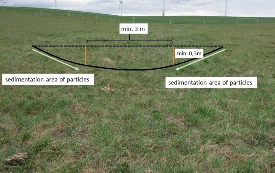
    Normally, only the vulnerable lowest area of an agricultural field ( channel shape, bottom slope) needs to be grassed. LfULG recommends 1-4 m wide side slopes with a passable gradient of 1:10 (10%) and a total width of the upper slope of about 6 m and 15 m for the lower slope. The bottom of the drainage channel must be at least 3 m wide and 0.3 m deep. The side slopes are responsible for sedimentation of particles and the bottom for infiltration of water.
    Author: Mona Pauer based on LfULG 2010, p.27
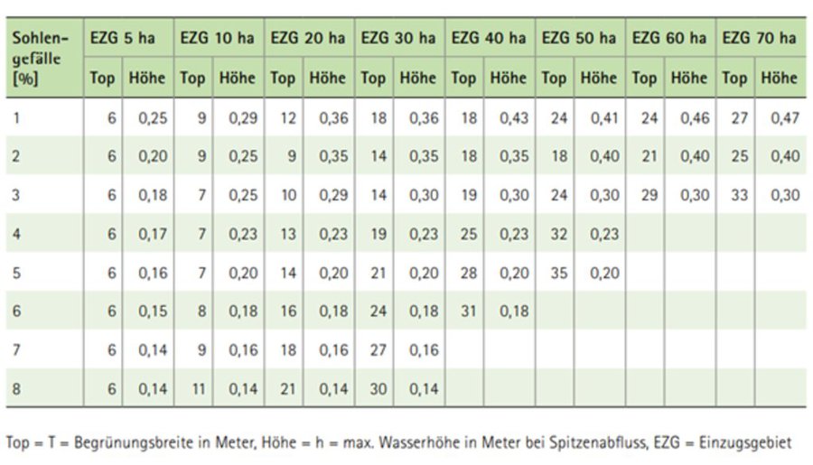
    Guide values for the width (Top) of drainage channels depending on the size of the catchment area (EZG), the slope of the riverbed (Sohlengefälle) and the height (Höhe) of the drainage channel.
    Author: LfULG 2015, p. 7

    ការបង្កើតនិងការថែទាំ៖​ សកម្មភាព ធាតុចូល និងថ្លៃដើម

    ការគណនាធាតុចូល​ និងថ្លៃដើម
    • ថ្លៃដើមត្រូវបានគណនា៖ ក្នុងតំបន់អនុវត្តបច្ចេកទេស (ទំហំ និងឯកត្តាផ្ទៃដី៖ 1 ha)
    • រូបិយប័ណ្ណសម្រាប់ការគណនាថ្លៃដើម៖
    • អត្រាប្តូរប្រាក់ (ទៅជាដុល្លារអាមេរិក)៖ 1 USD = 0.91 €
    • ថ្លៃឈ្នួលជាមធ្យមក្នុង ១ ថ្ងៃ៖ 18.70 € per hour
    កត្តាសំខាន់បំផុតដែលមានឥទ្ធិពលលើថ្លៃដើម
    Landowners complained that the additional yield (grass as fodder) would have no impact on their income. The loss of income due to the loss of arable land is greater and should be compensated by subsidy programs.
    សកម្មភាពបង្កើតបច្ចេកទេស
    1. reseeding of ryegrass (drill seed) (ពេលវេលា/ ភាពញឹកញាប់: spring)
    2. rolling (soil contact between plant and soil) (ពេលវេលា/ ភាពញឹកញាប់: spring)
    ធាតុចូល និងថ្លៃដើមសម្រាប់ការបង្កើតបច្ចេកទេស
    បញ្ជាក់ពីធាតុចូល ឯកតា បរិមាណ ថ្លៃដើមក្នុងមួយឯកតា (€) ថ្លៃធាតុចូលសរុប (€) % នៃថ្លៃដើមដែលចំណាយដោយអ្នកប្រើប្រាស់ដី
    កម្លាំងពលកម្ម
    seeding ha 1,0 20,19 20,19 100,0
    rolling ha 1,0 19,58 19,58 100,0
    សម្ភារៈដាំដុះ
    seeds ha 1,0 32,4 32,4 100,0
    ថ្លៃដើមសរុបក្នុងការបង្កើតបច្ចេកទេស 72.17
    ថ្លៃដើមសរុបក្នុងការបង្កើតបច្ចេកទេសគិតជាដុល្លារ 79.31
    សកម្មភាពថែទាំ
    1. mulching (ពេលវេលា/ ភាពញឹកញាប់: every spring)
    2. ploughing (ពេលវេលា/ ភាពញឹកញាប់: every 5 years)
    3. reseeding (ពេលវេលា/ ភាពញឹកញាប់: every 5 years)
    ធាតុចូលនិងថ្លៃដើមសម្រាប់ការថែទាំ
    បញ្ជាក់ពីធាតុចូល ឯកតា បរិមាណ ថ្លៃដើមក្នុងមួយឯកតា (€) ថ្លៃធាតុចូលសរុប (€) % នៃថ្លៃដើមដែលចំណាយដោយអ្នកប្រើប្រាស់ដី
    កម្លាំងពលកម្ម
    mulching ha 1,0 24,87 24,87 100,0
    ploughing ha 0,2 63,56 12,71 100,0
    reseeding ha 0,2 39,77 7,95 100,0
    សម្ភារៈដាំដុះ
    seeds 32,4 0,2 32,4 6,48 100,0
    ថ្លៃដើមសរុបសម្រាប់ការថែទាំដំណាំតាមបច្ចេកទេស 52.01
    ថ្លៃដើមសរុបសម្រាប់ការថែទាំដំណាំតាមបច្ចេកទេសគិតជាដុល្លារ 57.15

    បរិស្ថានធម្មជាតិ

    បរិមាណទឹកភ្លៀងជាមធ្យមប្រចាំឆ្នាំ
    • < 250 មម
    • 251-500 មម
    • 501-750 មម
    • 751-1,000 មម
    • 1,001-1,500 មម
    • 1,501-2,000 មម
    • 2,001-3,000 មម
    • 3,001-4,000 មម
    • > 4,000 មម
    តំបន់កសិអាកាសធាតុ
    • សើម
    • មានភ្លៀងមធ្យម
    • មានភ្លៀងតិចតួច
    • ស្ងួត
    លក្ខណៈសម្គាល់នៃអាកាសធាតុ
    បរិមាណទឹកភ្លៀងជាមធ្យមប្រចាំឆ្នាំគិតជា មម៖ 775.0
    ស្ថានីយឧតុនិយម៖​ https://whh-kliwes.de/mapview
    LGP: 209 days (https://www.umwelt.sachsen.de/dauer-der-vegetationsperiode-30631.html)
    ជម្រាល
    • រាបស្មើ (0-2%)
    • ជម្រាលតិចតួច (3-5%)
    • មធ្យម (6-10%)
    • ជម្រាលខ្ពស់បន្តិច (11-15%)
    • ទីទួល (16-30%)
    • ទីទួលចោត (31-60%)
    • ទីទួលចោតខ្លាំង (>60%)
    ទម្រង់ដី
    • ខ្ពង់រាប
    • កំពូលភ្នំ
    • ជម្រាលភ្នំ
    • ជម្រាលទួល
    • ជម្រាលជើងភ្នំ
    • បាតជ្រលងភ្នំ
    រយៈកម្ពស់ធៀបនឹងនីវ៉ូទឹកសមុទ្រ
    • 0-100 ម​
    • 101-500 ម
    • 501-1,000 ម
    • 1,001-1,500 ម
    • 1,501-2,000 ម
    • 2,001-2,500 ម
    • 2,501-3,000 ម
    • 3,001-4,000 ម
    • > 4,000 ម
    បច្ចេកទេសត្រូវបានអនុវត្តនៅក្នុង
    • សណ្ឋានដីប៉ោង
    • សណ្ឋានដីផត
    • មិនពាក់ព័ន្ធទាំងអស់
    ជម្រៅដី
    • រាក់ខ្លាំង (0-20 សម)
    • រាក់ (21-50 សម)
    • មធ្យម (51-80 សម)
    • ជ្រៅ (81-120 សម)
    • ជ្រៅខ្លាំង (> 120 សម)
    វាយនៈភាពដី (ដីស្រទាប់ខាងលើ)
    • គ្រើម/ មានពន្លឺ (ខ្សាច់)
    • មធ្យម (ល្បាយ, ល្បាប់)
    • ម៉ត់/ ធ្ងន់ (ឥដ្ឋ)
    វាយនភាពដី (>​ 20 សម ក្រោមស្រទាប់លើ)
    • គ្រើម/ មានពន្លឺ (ខ្សាច់)
    • មធ្យម (ល្បាយ, ល្បាប់)
    • ម៉ត់/ ធ្ងន់ (ឥដ្ឋ)
    កម្រិតសារធាតុសរីរាង្គក្នុងដី​​ស្រទាប់លើ
    • ខ្ពស់ (>3%)
    • មធ្យម (1-3%)
    • ទាប (<1%)
    ដង្ហើមទឹកក្នុងដី
    • ផ្ទៃខាងលើ
    • < 5 ម
    • 5-50 ម
    • > 50 ម
    ភាពអាចរកបាននៃទឹកលើដី
    • លើស
    • ល្អ
    • កម្រិតមធ្យម
    • មិនមាន/ គ្មាន
    គុណភាពទឹក (មិនបានធ្វើប្រព្រឹត្តិកម្ម)
    • ទឹកពិសារដែលមានគុណភាពល្អ
    • ទឹកពិសារដែលគ្មានគុណភាព (តម្រូវឱ្យមានការសំអាត)
    • ទឹកសម្រាប់តែការធ្វើកសិកម្ម (ស្រោចស្រព)
    • ទឹកមិនអាចប្រើប្រាស់បាន
    គុណភាពទឹក គឺផ្តោតទៅលើ៖ ទឹកលើផ្ទៃដី
    តើមានបញ្ហាទឹកប្រៃហូរចូល​​ដែរឬទេ?
    • បាទ/ចា៎
    • ទេ

    ការកើតឡើងនៃទឹកជំនន់
    • បាទ/ចា៎
    • ទេ
    ភាពសំបូរបែបនៃប្រភេទសត្វ
    • ខ្ពស់
    • កម្រិតមធ្យម
    • ទាប
    ភាពសំបូរបែបនៃជម្រកធម្មជាតិ
    • ខ្ពស់
    • កម្រិតមធ្យម
    • ទាប

    ចរិតលក្ខណៈរបស់អ្នកប្រើប្រាស់ដីដែលប្រើបច្ចេកទេស SLM

    ទីផ្សារ
    • សម្រាប់ហូបក្នុងគ្រួសារ (ផ្គត់ផ្គង់ខ្លួនឯង)
    • ពាក់កណ្តាលពាណិជ្ជកម្ម (ផ្គត់ផ្គង់ខ្លួនឯង/ ពាណិជ្ជកម្ម)
    • ពាណិជ្ជកម្ម/ ទីផ្សារ
    ចំណូលក្រៅកសិដ្ឋាន
    • តិចជាង 10% នៃចំណូល
    • 10-50% នៃចំណូល
    • ច្រើនជាង 50% នៃចំណូល
    កម្រិតជីវភាព
    • មិនល្អខ្លាំង
    • មិនល្អ
    • មធ្យម
    • មាន
    • មានខ្លាំង
    កម្រិតនៃការប្រើគ្រឿងយន្ត
    • ប្រើកម្លាំងពលកម្ម
    • ប្រើកម្លាំងសត្វ
    • គ្រឿងយន្ត/ ម៉ាស៊ីន
    នៅមួយកន្លែង ឬពនេចរ
    • នៅមួយកន្លែង
    • ពាក់កណ្តាលពនេចរ
    • ពនេចរ
    បុគ្គល ឬក្រុម
    • ធ្វើខ្លួនឯង/ គ្រួសារ
    • ជាក្រុម/ សហគមន៍
    • សហករ
    • មានបុគ្គលិក (ក្រុមហ៊ុន, រដ្ឋ)
    យេនឌ័រ
    • ស្ត្រី
    • បុរស
    អាយុ
    • កុមារ
    • យុវវ័យ
    • វ័យកណ្តាល
    • មនុស្សចាស់
    ផ្ទៃដីប្រើប្រាស់ក្នុងមួយគ្រួសារ
    • < 0.5 ហិកតា
    • 0.5-1 ហិកតា
    • 1-2 ហិកតា
    • 2-5 ហិកតា
    • 5-15 ហិកតា
    • 15-50 ហិកតា
    • 50-100 ហិកតា
    • 100-500 ហិកតា
    • 500-1,000 ហិកតា
    • 1,000-10,000 ហិកតា
    • > 10,000 ហិកតា
    មាត្រដ្ឋាន
    • ខ្នាតតូច
    • ខ្នាតមធ្យម
    • ខ្នាតធំ
    ភាពជាម្ចាស់ដីធ្លី
    • រដ្ឋ
    • ក្រុមហ៊ុន
    • ភូមិ
    • ក្រុម
    • ឯកជន មិនមានកម្មសិទ្ធ
    • ឯកជន មានកម្មសិទ្ធ
    សិទ្ធិប្រើប្រាស់ដី
    • អាស្រ័យផលសេរី (មិនមានការកំណត់)
    • ជាក្រុម (មានដែនកំណត់)
    • កិច្ចសន្យាជួល
    • ឯកជន
    សិទ្ធិប្រើប្រាស់ទឹក
    • អាស្រ័យផលសេរី (មិនមានការកំណត់)
    • ជាក្រុម (មានដែនកំណត់)
    • កិច្ចសន្យាជួល
    • ឯកជន
    ប្រើប្រាស់សេវាកម្ម និងហេដ្ឋារចនាសម្ព័ន្ធ
    សុខភាព

    មិនល្អ
    x
    ល្អ
    ការអប់រំ

    មិនល្អ
    x
    ល្អ
    ជំនួយបច្ចេកទេស

    មិនល្អ
    x
    ល្អ
    ការងារ (ឧ. ការងារក្រៅកសិដ្ឋាន)

    មិនល្អ
    x
    ល្អ
    ទីផ្សារ

    មិនល្អ
    x
    ល្អ
    ថាមពល

    មិនល្អ
    x
    ល្អ
    ផ្លូវ និងការដឹកជញ្ជូន

    មិនល្អ
    x
    ល្អ
    ទឹកផឹក និងអនាម័យ

    មិនល្អ
    x
    ល្អ
    សេវាកម្មហិរញ្ញវត្ថុ

    មិនល្អ
    x
    ល្អ

    ផលប៉ះពាល់

    ផលប៉ះពាល់សេដ្ឋកិច្ចសង្គម
    ផលិតកម្មចំណីសត្វ
    ថយចុះ
    x
    កើនឡើង


    The loss of arable land (used for forage oats) cannot be compensated by harvesting grass on the runoff path.

    គុណភាពចំណីសត្វ
    ថយចុះ
    x
    កើនឡើង

    ហានិភ័យនៃភាពបរាជ័យរបស់​​ផលិតកម្ម
    កើនឡើង
    x
    ថយចុះ

    ទំហំផ្ទៃដីផលិតកម្ម (ដីថ្មីដែលបានដាំដុះ/ ប្រើប្រាស់)
    ថយចុះ
    x
    កើនឡើង


    Measure does not affect yield, but means a loss of area.

    ការចំណាយលើធាតុចូលកសិកម្ម
    កើនឡើង
    x
    ថយចុះ


    Costs for seeds

    ចំណូលក្នុងកសិដ្ឋាន
    ថយចុះ
    x
    កើនឡើង

    ភាពសម្បូរបែបប្រភពប្រាក់​ចំណូល
    ថយចុះ
    x
    កើនឡើង

    បន្ទុកការងារ
    កើនឡើង
    x
    ថយចុះ


    If a whole field is converted to a grassed waterway workload decreases. However, for a typical grassed waterway (just greening of the thalweg) an increase in workload can be expected.

    ផលប៉ះពាល់វប្បធម៌សង្គម
    ផលប៉ះពាល់លើអេកូឡូស៊ី
    លំហូរទឹកលើផ្ទៃដី
    កើនឡើង
    x
    ថយចុះ


    Reduction in surface water runoff.

    សំណើមដី
    ថយចុះ
    x
    កើនឡើង

    គម្របដី
    កាត់បន្ថយ
    x
    ប្រសើរជាងមុន

    ការបាត់បង់ដី
    កើនឡើង
    x
    ថយចុះ

    ការកើនឡើងដី
    ថយចុះ
    x
    កើនឡើង

    ដីហាប់
    កើនឡើង
    x
    កាត់បន្ថយ

    សារធាតុសរីរាង្គដី/ការបូនក្រោមដី
    ថយចុះ
    x
    កើនឡើង

    ដំណាំគម្របដី
    ថយចុះ
    x
    កើនឡើង

    ភាពសម្បូរបែបនៃរុក្ខជាតិ
    ថយចុះ
    x
    កើនឡើង

    ប្រភេទរាតត្បាត
    កើនឡើង
    x
    កាត់បន្ថយ

    ភាពសម្បូរបែបនៃទីជំរក
    ថយចុះ
    x
    កើនឡើង

    ការគ្រប់គ្រងកត្តាចង្រៃ/ ជំងឺ
    ថយចុះ
    x
    កើនឡើង

    ផលប៉ះពាល់នៃគ្រោះរាំងស្ងួត
    កើនឡើង
    x
    ថយចុះ

    ផលប៉ះពាល់ក្នុងបរិវេណ
    ទឹកដែលអាចទាញមកប្រើប្រាស់បាន (ទឹកក្រោមដី ទឹក-springs)
    ថយចុះ
    x
    កើនឡើង

    ទឹកក្រោមដី/ ការបំពុលទឹកទន្លេ
    កើនឡើង
    x
    កាត់បន្ថយ

    សមត្ថភាពចម្រោះ (ដោយដី ដំណាំ ដីសើម)
    កាត់បន្ថយ
    x
    ប្រសើរជាងមុន

    ខូចខាតដល់ស្រែអ្នកជិតខាង
    កើនឡើង
    x
    កាត់បន្ថយ

    ខូចខាតដល់ហេដ្ឋារចនាសម្ព័ន្ធសាធារណៈ/ឯកជន
    កើនឡើង
    x
    កាត់បន្ថយ


    No more soil deposits in the yard/on the street.

    ការវិភាគថ្លៃដើម និងអត្ថប្រយោជន៍

    អត្ថប្រយោជន៍បើប្រៀបធៀបនឹងថ្លៃដើមក្នុងការបង្កើតបច្ចេកទេស
    រយៈពេលខ្លី
    អវិជ្ជមានខ្លាំង
    x
    វិជ្ជមានខ្លាំង

    រយៈពេលវែង
    អវិជ្ជមានខ្លាំង
    x
    វិជ្ជមានខ្លាំង

    អត្ថប្រយោជន៍បើប្រៀបធៀបនឹងថ្លៃដើមក្នុងការថែទាំបច្ចេកទេស
    រយៈពេលខ្លី
    អវិជ្ជមានខ្លាំង
    x
    វិជ្ជមានខ្លាំង

    រយៈពេលវែង
    អវិជ្ជមានខ្លាំង
    x
    វិជ្ជមានខ្លាំង

    ការប្រែប្រួលអាកាសធាតុ

    ការប្រែប្រួលអាកាសធាតុ
    សីតុណ្ហភាពប្រចាំរដូវកាល កើនឡើង

    មិនល្អ
    x
    ល្អណាស់
    រដូវកាល: និទាឃរដូវ
    គ្រោះអាកាសធាតុ (មហន្តរាយ) ​
    ព្យុះភ្លៀងតាមតំបន់

    មិនល្អ
    x
    ល្អណាស់

    ការទទួលយក និងការបន្ស៊ាំ

    ភាគរយនៃអ្នកប្រើប្រាស់ដីនៅតំបន់ដែលបានទទួលយកបច្ចេកទេស
    • តែមួយករណី /ពិសោធន៍
    • 1-10%
    • 11-50%
    • > 50%
    ក្នុងចំណោមអ្នកទទួលយកបច្ចេកទេសនេះ តើមាន​ប៉ុន្មាន​ភាគរយ​ដែល​បាន​អនុវត្តន៍​ដោយ​មិន​បាន​ទទួលការលើក​ទឹកចិត្ត​ជាសម្ភារៈ?
    • 0-10%
    • 11-50%
    • 51-90%
    • 91-100%
    តើថ្មីៗនេះ បច្ចេកទេសនេះត្រូវបានកែតម្រូវ​ដើម្បី​បន្ស៊ាំ​ទៅនឹង​ស្ថាន​ភាព​ប្រែប្រួល​ដែរ​ឬទេ?
    • បាទ/ចា៎
    • ទេ
    ចំពោះលក្ខខណ្ឌប្រែប្រួលណាមួយដែលត្រូវបានបន្ស៊ាំ?
    • ការប្រែប្រួលអាកាសធាតុ/គ្រោះមហន្តរាយធម្មជាតិ
    • បម្រែបម្រួលទីផ្សារ
    • កម្លាំងពលកម្មដែលអាចរកបាន (ចំណាកស្រុក)

    សេក្តីសន្និដ្ឋាន និងមេរៀនបទពិសោធន៍

    ភាពខ្លាំង: ទស្សនៈអ្នកប្រើប្រាស់ដី
    • Compared to other erosion control measures, the area of the grassed waterway can continue to be used (extensively) for forage and grazing.
    • In Germany, the greened areas could be used as required greening areas for the direct payments of the agricultural policy.
    ភាពខ្លាំង: ទស្សនៈរបស់អ្នកចងក្រង ឬបុគ្គលសំខាន់ផ្សេងទៀត
    • Grassed waterways are highly recommended and beneficial in preventing on-site gully erosion and off-site pollution of water bodies.
    • Due to their more technical background, the conservation value is not as high as for other measures, but they are still considered as a biotope network as well as a habitat for grassland breeders when extensively managed.
    ចំណុចខ្សោយ/ គុណវិបត្តិ/ ហានិភ័យ​ : ទស្សនៈអ្នកប្រើប្រាស់ដីវិធីដោះស្រាយ
    • In Germany, grassland becomes permanent if it is not converted within five years. This often leads to a conflict of interest between landowners and land-users. A permanent change in land-use (from arable land to permanent grassland) would mean a loss in land value. As a result, the farmers plough and reseed the area after five years. With a change in regulations for certain measures, e.g. if land is used for nature conservation, it could remain cropland after five years without being converted.
    • A structure in the middle of a field is impractical in terms of tracks for machinery. Sometimes it may be beneficial to green the entire field or subdivide the field with a linear structure.
    ចំណុចខ្សោយ/ គុណវិបត្តិ/ ហានិភ័យ​ : ទស្សនៈរបស់អ្នកចងក្រង ឬបុគ្គលសំខាន់ផ្សេងទៀតវិធីដោះស្រាយ

    ឯកសារយោង

    អ្នកចងក្រង
    • Felix Witing
    Editors
    • Michael Strauch
    • Mona Pauer
    អ្នកត្រួតពិនិត្យ
    • William Critchley
    • Rima Mekdaschi Studer
    កាលបរិច្ឆេទនៃការអនុវត្ត: 22 ខែ មិថុនា ឆ្នាំ 2021
    កែតម្រូវចុងក្រោយ: 14 ខែ សីហា ឆ្នាំ 2023
    បុគ្គលសំខាន់ៗ
    ការពណ៌នាលម្អិតក្នុងប្រព័ន្ធគ្រប់គ្រងទិន្នន័យរបស់វ៉ូខេត
    ទិន្នន័យ SLM ភ្ជាប់ជាមួយ
    ឯកសារនេះត្រូវបានសម្របសម្រួលដោយ
    ស្ថាប័ន៖ គម្រោង
    ការភ្ជាប់ទៅកាន់ពត៌មានពាក់ព័ន្ធលើប្រព័ន្ធអនឡាញ
    This work is licensed under Creative Commons Attribution-NonCommercial-ShareaAlike 4.0 International