Excavation at Leyhele (IUCN archieve)

Sub-Surface Dams (SSD) (ប្រទេសកេនយ៉ា)

ការពណ៌នា

These are constructions stretching across the sand filled dry riverbed, down towards the impermeable floor of the riverbed. They are totally submerged into the ground. For example by fully covering after construction by sand. This are done along dry rivers with huge sand deposits, which has high yield potential and where water can be easily extracted. The aim is to raise groundwater tables and increase the storage capacity for water withdrawals.

The technology is applied in northern rangeland of Isiolo County which is managed under communal management systems. The aim of technology to reduce pasture and water availability imbalances. The dimensions of sub-surface dam include: a length of water spread (103m),width of the dam (15m), width of water spread (18m), effective dam height (2m), volume of retained sand (103 x 0.5(15 +18) x0.5 x2.0 = 5098.50m3) and the volume of water that can be abstracted from the sand bed (25/100x 5098.50m3 = 1274.6.36m3).
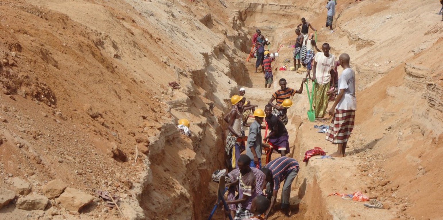
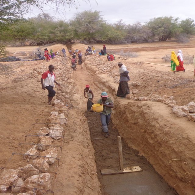
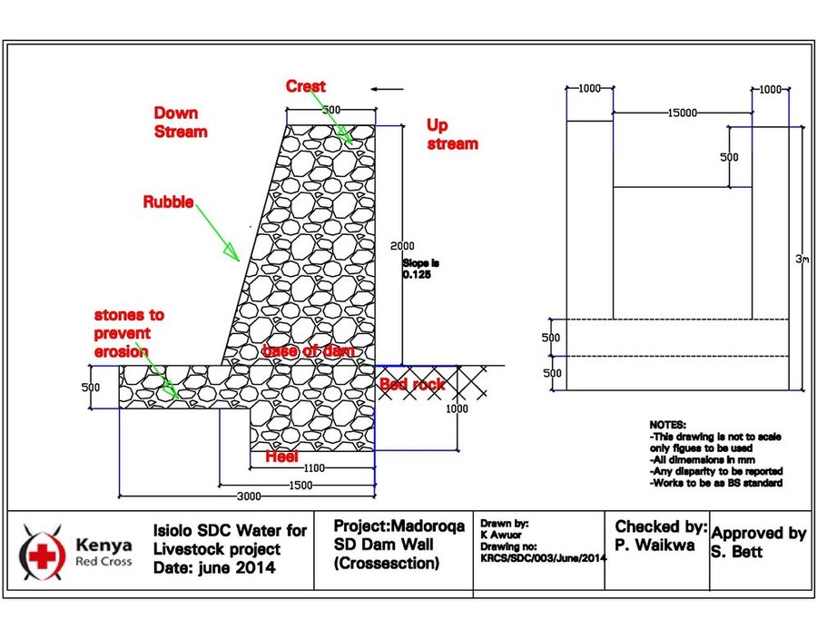
The technology functions as underground water storage infrastructure and the typical activities include, excavation of top porous soil, excavation of sample pits within the excavated area, checking filtration rates of soil, compaction of soil on which dam liners are laid, smoothing the sharp liners along which the dam liners are laid, making grooves to anchor the dam liner, laying the dam liner, anchoring the dam liner with a mixture of cement, water proof and sand with water (motor) and finally drying of the motor and filling back of sand.
The development of Sub-Surface Dams (SSDs) was done through Cash for Work program where local labours comprising of 40-50 persons are engaged in excavation, compactions and developing the liners. Farm tools like jembe, panga, spades and human labour are required to develop the SSD. The technology improves water supply/availability, thereby extending the period of livestock grazing in areas where typically water is depleted before the pasture hence improves water access for livestock in ways that support wider management and utilization of the rangeland and as such strength the resilience of pastoralists to droughts. This effectively gives pastoral groups, an extra grazing time (typically 2 extra months), a period usually not too long to encourage land degradation through over-grazing but long enough to enable pastoralist utilize the remaining pasture in wet season grazing areas. In so doing, the technology enable balanced use of vast communal lands without livestock retreating to dry season grazing areas.
In the process of the landscape level participatory planning with the communities: i) they identified different challenges, including need for decommissioning certain water points that they consider are contributing to over grazing and also attracting other communities, hence drive frequent conflicts, secondly, ii) they mapped areas in the rangeland where there is mismatch between water and pasture availability, most of these areas are in wet season grazing areas. So the next discussion was on what strategic water infrastructures that will enable herders to graze for 2 -3 extra months to enable them utilize the grass before they migrate to the traditional dry season grazing areas. So by design, the technology should only yield water that can allow settling for those extra months, not longer to the detriment of the rangeland
The technology was instrumental in fostering both balanced utilization of land and strengthening sustainable use of the vast rangeland by ensuring that herders utilize available pastures in the wet seasons grazing areas before moving to dry seasons grazing areas. The water stored through the technology stays longer, in this case study, the water lasted for 5 months after the end of the rainy season .
The area receives bimodal rainfall, long rain in March-May and short rain in November-December. With changing seasons/climate, the dry seasons can last up to 1 year in case of rainfall failure. Typically, dry seasons are 6-7 months (May- November).
Normally, the water is depleted within 2 months after the rainy period. The technology is also cheap and easy to understand and construct (especially in areas with clay as the underlying impermeable material) with a possibility of the communities to be taught how to identify suitable site and the entire process of construction. However, in areas without clay soil, the excavation of clay and transportation can be labour intensive and expensive.

ទីតាំង

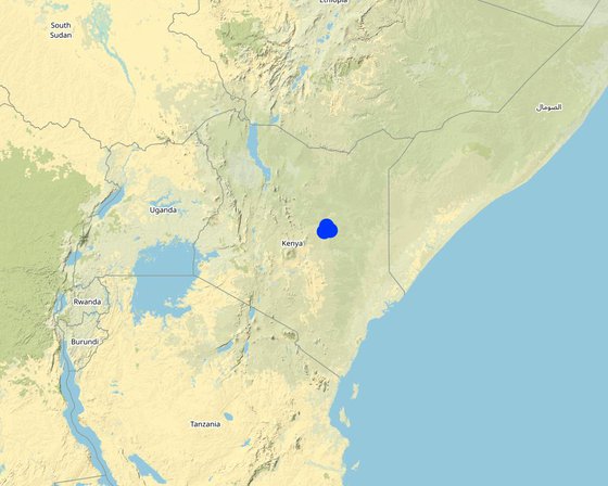
ទីតាំង: Garba Tula, Isiolo County, Northern Kenya, ប្រទេសកេនយ៉ា

ចំនួនទីកន្លែងបច្ចេកទេស ដែលវិភាគ: 2-10 កន្លែង

ចំណុចយោងភូមិសាស្ត្រនៃទីតាំងជ្រើសរើស
  • 38.63623, 0.58383
  • 38.85596, 0.64425
  • 38.72412, 0.79805

ការសាយភាយនៃបច្ចេកទេស: អនុវត្តនៅកន្លែងជាក់លាក់មួយ/ ប្រមូលផ្តុំនៅតំបន់តូចៗ

តើស្ថិតក្នុងតំបន់ការពារអចិន្ត្រៃយ៍?:

កាលបរិច្ឆេទនៃការអនុវត្ត:

ប្រភេទនៃការណែនាំឱ្យអនុវត្តន៍៖
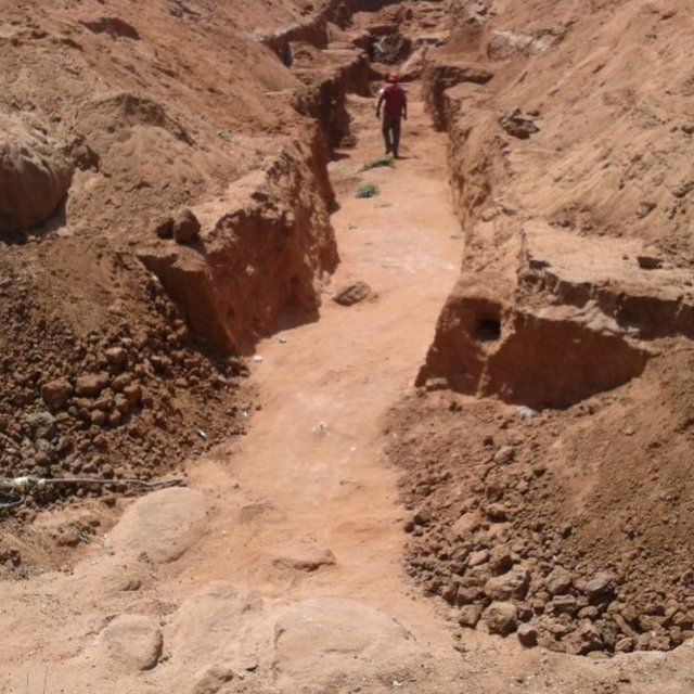
Excavation process (from IUCN archive)
Excavation process (IUCN archieve)

ចំណាត់ថ្នាក់នៃបច្ចេកទេស

គោលបំណងចម្បងៗ
  • ធ្វើឱ្យប្រសើរឡើងនូវផលិតកម្ម
  • កាត់បន្ថយ, បង្ការ, ស្តារឡើងវិញនូវការធ្លាក់ចុះគុណភាពដី
  • អភិរក្សប្រព័ន្ធអេកូឡូស៊ី
  • ការពារតំបន់ទីជម្រាល/តំបន់ខ្សែទឹកខាងក្រោមបញ្ចូលជាមួយបច្ចេកទេសផ្សេងទៀត
  • អភិរក្ស/ធ្វើឱ្យប្រសើរឡើងជីវចម្រុះ
  • កាត់បន្ថយហានិភ័យនៃគ្រោះមហន្តរាយ
  • បន្ស៊ាំទៅនឹងការប្រែប្រួលអាកាសធាតុ/គ្រោះមហន្តរាយ និងផលប៉ះពាល់របស់វា
  • កាត់បន្ថយការប្រែប្រួលអាកាសធាតុ និងផលប៉ះពាល់របស់វា
  • បង្កើតផលប្រយោជន៍សេដ្ឋកិច្ច
  • បង្កើតផលប្រយោជន៍សង្គម
ការប្រើប្រាស់ដី

  • ដីសម្រាប់ចិញ្ចឹមសត្វ
    • ពាក់កណ្តាលពនេចរ
ការផ្គត់ផ្គង់ទឹក
  • ទឹកភ្លៀង
  • ទឹកភ្លៀង និងប្រព័ន្ធស្រោចស្រព
  • ប្រព័ន្ធស្រោចស្រពទាំងស្រុង

គោលបំណងទាក់ទងនឹងការធ្លាក់ចុះគុណភាពដី
  • ការការពារការធ្លាក់ចុះគុណភាពដី
  • ការកាត់បន្ថយការធ្លាក់ចុះគុណភាពដី
  • ការជួសជុល/ ស្តារឡើងវិញនៃឱនភាពដីធ្ងន់ធ្ងរ
  • ការបន្ស៊ាំទៅនឹងការធ្លាក់ចុះគុណភាពដី
  • ដែលមិនអាចអនុវត្តបាន
ប្រភេទនៃការធ្លាក់ចុះគុណភាពដីដែលបានដោះស្រាយ
  • ផ្សេងៗ -
ក្រុម SLM
  • កសិរុក្ខកម្ម (pastoralism) និងការគ្រប់គ្រងដីសម្រាប់ចិញ្ចឹមសត្វ
វិធានការ SLM
  • វិធានការរចនាស័ម្ពន្ធ - S5: ទំនប់ ថ្លុក ស្រះ

គំនូរបច្ចេកទេស

លក្ខណៈបច្ចេកទេស
None
Author: Guyo Roba

ការបង្កើតនិងការថែទាំ៖​ សកម្មភាព ធាតុចូល និងថ្លៃដើម

ការគណនាធាតុចូល​ និងថ្លៃដើម
  • ថ្លៃដើមត្រូវបានគណនា៖ ក្នុងឯកតាបច្ចេកទេស (ឯកត្តា៖ chamber)
  • រូបិយប័ណ្ណសម្រាប់ការគណនាថ្លៃដើម៖ ដុល្លារ
  • អត្រាប្តូរប្រាក់ (ទៅជាដុល្លារអាមេរិក)៖ 1 USD = មិនមាន
  • ថ្លៃឈ្នួលជាមធ្យមក្នុង ១ ថ្ងៃ៖ 3.5 USD per day
កត្តាសំខាន់បំផុតដែលមានឥទ្ធិពលលើថ្លៃដើម
Distance of the sub-surface dam from villages, extent of destruction by floods and human activities
សកម្មភាពបង្កើតបច្ចេកទេស
  1. Removing sand over dyke and man-days for excavating and transporting soil to dam site (ពេលវេលា/ ភាពញឹកញាប់: 21 days for 45 casual labourers)
  2. Building and compaction soil in dam wall (ពេលវេលា/ ភាពញឹកញាប់: 3 days for 45 casual labourers)
  3. Supplying water for compaction (ពេលវេលា/ ភាពញឹកញាប់: 0.5 day for 45 casual labourers)
  4. Back-filling sand on dam (ពេលវេលា/ ភាពញឹកញាប់: 1 day for 45 casual labourers)
  5. Supplying water for compacting clay in dam wall (ពេលវេលា/ ភាពញឹកញាប់: 2 days for 45 casual labourers)
  6. Compacting soil and placing liners (ពេលវេលា/ ភាពញឹកញាប់: 12 days for 45 casual labourers)
ធាតុចូល និងថ្លៃដើមសម្រាប់ការបង្កើតបច្ចេកទេស
បញ្ជាក់ពីធាតុចូល ឯកតា បរិមាណ ថ្លៃដើមក្នុងមួយឯកតា (ដុល្លារ) ថ្លៃធាតុចូលសរុប (ដុល្លារ) % នៃថ្លៃដើមដែលចំណាយដោយអ្នកប្រើប្រាស់ដី
កម្លាំងពលកម្ម
tools - jembe, spade etc. pieces 80,0 5,33 426,4
Removing sand over dyke and Man-days for excavating and transporting soil to dam site per day 945,0 4,0 3780,0
Building and compaction soil in dam wall per day 135,0 4,0 540,0
សម្ភារៈ
Supplying water for compaction per day 22,5 4,0 90,0
Back-filling sand on dam per day 45,0 4,0 180,0
Supplying water for compacting soil in dam wall per day 90,0 4,0 360,0
Compacting soil and placing liners per day 540,0 4,0 2160,0
ថ្លៃដើមសរុបក្នុងការបង្កើតបច្ចេកទេស 7'536.4
សកម្មភាពថែទាំ
  1. Training of communities to manage and maintain the structures (ពេលវេលា/ ភាពញឹកញាប់: yearly)
ធាតុចូលនិងថ្លៃដើមសម្រាប់ការថែទាំ
បញ្ជាក់ពីធាតុចូល ឯកតា បរិមាណ ថ្លៃដើមក្នុងមួយឯកតា (ដុល្លារ) ថ្លៃធាតុចូលសរុប (ដុល្លារ) % នៃថ្លៃដើមដែលចំណាយដោយអ្នកប្រើប្រាស់ដី
កម្លាំងពលកម្ម
Labour for site protection and maintenance of hygiene per site 10,0 100,0 1000,0
ថ្លៃដើមសរុបសម្រាប់ការថែទាំដំណាំតាមបច្ចេកទេស 1'000.0

បរិស្ថានធម្មជាតិ

បរិមាណទឹកភ្លៀងជាមធ្យមប្រចាំឆ្នាំ
  • < 250 មម
  • 251-500 មម
  • 501-750 មម
  • 751-1,000 មម
  • 1,001-1,500 មម
  • 1,501-2,000 មម
  • 2,001-3,000 មម
  • 3,001-4,000 មម
  • > 4,000 មម
តំបន់កសិអាកាសធាតុ
  • សើម
  • មានភ្លៀងមធ្យម
  • មានភ្លៀងតិចតួច
  • ស្ងួត
លក្ខណៈសម្គាល់នៃអាកាសធាតុ
because of the climate change, the rainfall is becoming more erratic.
ស្ថានីយឧតុនិយម៖​ Isiolo
ជម្រាល
  • រាបស្មើ (0-2%)
  • ជម្រាលតិចតួច (3-5%)
  • មធ្យម (6-10%)
  • ជម្រាលខ្ពស់បន្តិច (11-15%)
  • ទីទួល (16-30%)
  • ទីទួលចោត (31-60%)
  • ទីទួលចោតខ្លាំង (>60%)
ទម្រង់ដី
  • ខ្ពង់រាប
  • កំពូលភ្នំ
  • ជម្រាលភ្នំ
  • ជម្រាលទួល
  • ជម្រាលជើងភ្នំ
  • បាតជ្រលងភ្នំ
រយៈកម្ពស់ធៀបនឹងនីវ៉ូទឹកសមុទ្រ
  • 0-100 ម​
  • 101-500 ម
  • 501-1,000 ម
  • 1,001-1,500 ម
  • 1,501-2,000 ម
  • 2,001-2,500 ម
  • 2,501-3,000 ម
  • 3,001-4,000 ម
  • > 4,000 ម
បច្ចេកទេសត្រូវបានអនុវត្តនៅក្នុង
  • សណ្ឋានដីប៉ោង
  • សណ្ឋានដីផត
  • មិនពាក់ព័ន្ធទាំងអស់
ជម្រៅដី
  • រាក់ខ្លាំង (0-20 សម)
  • រាក់ (21-50 សម)
  • មធ្យម (51-80 សម)
  • ជ្រៅ (81-120 សម)
  • ជ្រៅខ្លាំង (> 120 សម)
វាយនៈភាពដី (ដីស្រទាប់ខាងលើ)
  • គ្រើម/ មានពន្លឺ (ខ្សាច់)
  • មធ្យម (ល្បាយ, ល្បាប់)
  • ម៉ត់/ ធ្ងន់ (ឥដ្ឋ)
វាយនភាពដី (>​ 20 សម ក្រោមស្រទាប់លើ)
  • គ្រើម/ មានពន្លឺ (ខ្សាច់)
  • មធ្យម (ល្បាយ, ល្បាប់)
  • ម៉ត់/ ធ្ងន់ (ឥដ្ឋ)
កម្រិតសារធាតុសរីរាង្គក្នុងដី​​ស្រទាប់លើ
  • ខ្ពស់ (>3%)
  • មធ្យម (1-3%)
  • ទាប (<1%)
ដង្ហើមទឹកក្នុងដី
  • ផ្ទៃខាងលើ
  • < 5 ម
  • 5-50 ម
  • > 50 ម
ភាពអាចរកបាននៃទឹកលើដី
  • លើស
  • ល្អ
  • កម្រិតមធ្យម
  • មិនមាន/ គ្មាន
គុណភាពទឹក (មិនបានធ្វើប្រព្រឹត្តិកម្ម)
  • ទឹកពិសារដែលមានគុណភាពល្អ
  • ទឹកពិសារដែលគ្មានគុណភាព (តម្រូវឱ្យមានការសំអាត)
  • ទឹកសម្រាប់តែការធ្វើកសិកម្ម (ស្រោចស្រព)
  • ទឹកមិនអាចប្រើប្រាស់បាន
គុណភាពទឹក គឺផ្តោតទៅលើ៖
តើមានបញ្ហាទឹកប្រៃហូរចូល​​ដែរឬទេ?
  • បាទ/ចា៎
  • ទេ

ការកើតឡើងនៃទឹកជំនន់
  • បាទ/ចា៎
  • ទេ
ភាពសំបូរបែបនៃប្រភេទសត្វ
  • ខ្ពស់
  • កម្រិតមធ្យម
  • ទាប
ភាពសំបូរបែបនៃជម្រកធម្មជាតិ
  • ខ្ពស់
  • កម្រិតមធ្យម
  • ទាប

ចរិតលក្ខណៈរបស់អ្នកប្រើប្រាស់ដីដែលប្រើបច្ចេកទេស SLM

ទីផ្សារ
  • សម្រាប់ហូបក្នុងគ្រួសារ (ផ្គត់ផ្គង់ខ្លួនឯង)
  • ពាក់កណ្តាលពាណិជ្ជកម្ម (ផ្គត់ផ្គង់ខ្លួនឯង/ ពាណិជ្ជកម្ម)
  • ពាណិជ្ជកម្ម/ ទីផ្សារ
ចំណូលក្រៅកសិដ្ឋាន
  • តិចជាង 10% នៃចំណូល
  • 10-50% នៃចំណូល
  • ច្រើនជាង 50% នៃចំណូល
កម្រិតជីវភាព
  • មិនល្អខ្លាំង
  • មិនល្អ
  • មធ្យម
  • មាន
  • មានខ្លាំង
កម្រិតនៃការប្រើគ្រឿងយន្ត
  • ប្រើកម្លាំងពលកម្ម
  • ប្រើកម្លាំងសត្វ
  • គ្រឿងយន្ត/ ម៉ាស៊ីន
នៅមួយកន្លែង ឬពនេចរ
  • នៅមួយកន្លែង
  • ពាក់កណ្តាលពនេចរ
  • ពនេចរ
បុគ្គល ឬក្រុម
  • ធ្វើខ្លួនឯង/ គ្រួសារ
  • ជាក្រុម/ សហគមន៍
  • សហករ
  • មានបុគ្គលិក (ក្រុមហ៊ុន, រដ្ឋ)
យេនឌ័រ
  • ស្ត្រី
  • បុរស
អាយុ
  • កុមារ
  • យុវវ័យ
  • វ័យកណ្តាល
  • មនុស្សចាស់
ផ្ទៃដីប្រើប្រាស់ក្នុងមួយគ្រួសារ
  • < 0.5 ហិកតា
  • 0.5-1 ហិកតា
  • 1-2 ហិកតា
  • 2-5 ហិកតា
  • 5-15 ហិកតា
  • 15-50 ហិកតា
  • 50-100 ហិកតា
  • 100-500 ហិកតា
  • 500-1,000 ហិកតា
  • 1,000-10,000 ហិកតា
  • > 10,000 ហិកតា
មាត្រដ្ឋាន
  • ខ្នាតតូច
  • ខ្នាតមធ្យម
  • ខ្នាតធំ
ភាពជាម្ចាស់ដីធ្លី
  • រដ្ឋ
  • ក្រុមហ៊ុន
  • ភូមិ
  • ក្រុម
  • ឯកជន មិនមានកម្មសិទ្ធ
  • ឯកជន មានកម្មសិទ្ធ
សិទ្ធិប្រើប្រាស់ដី
  • អាស្រ័យផលសេរី (មិនមានការកំណត់)
  • ជាក្រុម (មានដែនកំណត់)
  • កិច្ចសន្យាជួល
  • ឯកជន
សិទ្ធិប្រើប្រាស់ទឹក
  • អាស្រ័យផលសេរី (មិនមានការកំណត់)
  • ជាក្រុម (មានដែនកំណត់)
  • កិច្ចសន្យាជួល
  • ឯកជន
ប្រើប្រាស់សេវាកម្ម និងហេដ្ឋារចនាសម្ព័ន្ធ
សុខភាព

មិនល្អ
x
ល្អ
ការអប់រំ

មិនល្អ
x
ល្អ
ជំនួយបច្ចេកទេស

មិនល្អ
x
ល្អ
ការងារ (ឧ. ការងារក្រៅកសិដ្ឋាន)

មិនល្អ
x
ល្អ
ទីផ្សារ

មិនល្អ
x
ល្អ
ថាមពល

មិនល្អ
x
ល្អ
ផ្លូវ និងការដឹកជញ្ជូន

មិនល្អ
x
ល្អ
ទឹកផឹក និងអនាម័យ

មិនល្អ
x
ល្អ
សេវាកម្មហិរញ្ញវត្ថុ

មិនល្អ
x
ល្អ

ផលប៉ះពាល់

ផលប៉ះពាល់សេដ្ឋកិច្ចសង្គម
ផលិតកម្មសត្វ
ថយចុះ
x
កើនឡើង

ការគ្រប់គ្រងដី
រារាំង
x
ភាពសាមញ្ញ

ទឹកដែលអាចប្រើប្រាស់​បាន​សម្រាប់​ការចិញ្ចឹមសត្វ
ថយចុះ
x
កើនឡើង

ផលប៉ះពាល់វប្បធម៌សង្គម
ផលប៉ះពាល់លើអេកូឡូស៊ី
ផលប៉ះពាល់នៃគ្រោះរាំងស្ងួត
កើនឡើង
x
ថយចុះ

ផលប៉ះពាល់ក្នុងបរិវេណ
ទឹកដែលអាចទាញមកប្រើប្រាស់បាន (ទឹកក្រោមដី ទឹក-springs)
ថយចុះ
x
កើនឡើង

ការវិភាគថ្លៃដើម និងអត្ថប្រយោជន៍

អត្ថប្រយោជន៍បើប្រៀបធៀបនឹងថ្លៃដើមក្នុងការបង្កើតបច្ចេកទេស
រយៈពេលខ្លី
អវិជ្ជមានខ្លាំង
x
វិជ្ជមានខ្លាំង

រយៈពេលវែង
អវិជ្ជមានខ្លាំង
x
វិជ្ជមានខ្លាំង

អត្ថប្រយោជន៍បើប្រៀបធៀបនឹងថ្លៃដើមក្នុងការថែទាំបច្ចេកទេស
រយៈពេលខ្លី
អវិជ្ជមានខ្លាំង
x
វិជ្ជមានខ្លាំង

រយៈពេលវែង
អវិជ្ជមានខ្លាំង
x
វិជ្ជមានខ្លាំង

The technology has limited running and maintenance costs once its done fairly well.

ការប្រែប្រួលអាកាសធាតុ

គ្រោះអាកាសធាតុ (មហន្តរាយ) ​
រាំងស្ងួត

មិនល្អ
x
ល្អណាស់
ទឹកជំនន់ទូទៅ (ទន្លេ)

មិនល្អ
x
ល្អណាស់

ការទទួលយក និងការបន្ស៊ាំ

ភាគរយនៃអ្នកប្រើប្រាស់ដីនៅតំបន់ដែលបានទទួលយកបច្ចេកទេស
  • តែមួយករណី /ពិសោធន៍
  • 1-10%
  • 11-50%
  • > 50%
ក្នុងចំណោមអ្នកទទួលយកបច្ចេកទេសនេះ តើមាន​ប៉ុន្មាន​ភាគរយ​ដែល​បាន​អនុវត្តន៍​ដោយ​មិន​បាន​ទទួលការលើក​ទឹកចិត្ត​ជាសម្ភារៈ?
  • 0-10%
  • 11-50%
  • 51-90%
  • 91-100%
តើថ្មីៗនេះ បច្ចេកទេសនេះត្រូវបានកែតម្រូវ​ដើម្បី​បន្ស៊ាំ​ទៅនឹង​ស្ថាន​ភាព​ប្រែប្រួល​ដែរ​ឬទេ?
  • បាទ/ចា៎
  • ទេ
ចំពោះលក្ខខណ្ឌប្រែប្រួលណាមួយដែលត្រូវបានបន្ស៊ាំ?
  • ការប្រែប្រួលអាកាសធាតុ/គ្រោះមហន្តរាយធម្មជាតិ
  • បម្រែបម្រួលទីផ្សារ
  • កម្លាំងពលកម្មដែលអាចរកបាន (ចំណាកស្រុក)

សេក្តីសន្និដ្ឋាន និងមេរៀនបទពិសោធន៍

ភាពខ្លាំង: ទស្សនៈអ្នកប្រើប្រាស់ដី
  • The technology created opportunity to graze in wet season grazing areas for an averge extra 2 months period after rainy seasons. The technology has provided additional water that gave herders extra days to graze in wet season areas and utilize the pasture that would have been unutilized due to water constrains. In so doing, the land users utilized the pasture without retreating to traditional dry season grazing areas.
  • The extra grazing months has reduced overall livestock mortality during droughts and also improved resilience of pastoral community.
  • The distance travelled and effort required to access water was reduced. Community members reported reduced distances covered and time spent in search of water for livestock. In some instances the distance reduced from 12-15 Km to 3 Km. Community members also mentioned reduction in conflict incidences over water resources in some areas due to adequate supply of water as a result of construction of water infrastructure.
  • The balanced utilization of the grazing area through SSD water provision, enables herd to graze in wet season grazing for slightly longer period and utilize pasture optimally, this however, does not mean that during that garzing period, there will be overgrazing. The volume of water available restricts the number of animals sustained by the grazing area.
ភាពខ្លាំង: ទស្សនៈរបស់អ្នកចងក្រង ឬបុគ្គលសំខាន់ផ្សេងទៀត
  • The technology has created an opportunity to optimally use the grazing area and overall reduced land degradation. The technology Improves access to water for livestock in ways which promote more sustainable management of rangeland resources and as such strengthening the resilience of local communities.
  • The validation process prior to construction of the SSD is draws critical lessons of identifying and agreeing on where to construct the SSD in a way that fit within broader sustainable rangeland management in a manner that ensured sustainable and efficient utilization of pasture and browse resources in targeted areas. The increase in water supply allowed livestock to graze additional 2-3 months in target areas before shifting to dry grazing areas where previously they migrated before exhausting the pasture and browse resources due to water scarcity. The dry season grazing area is towards Merti, in Kom and Sabarwawa where there are deep boreholes, under, lock and key and only opened during dry seasons. In typical year, the dry season period is about 7 months. But when one rain season fail it goes to about 11 months.
ចំណុចខ្សោយ/ គុណវិបត្តិ/ ហានិភ័យ​ : ទស្សនៈអ្នកប្រើប្រាស់ដីវិធីដោះស្រាយ
  • When the construction season for SSD is not well planned, there is likelihood/risks of the dams being washed away by flash floods. Better planning and timing of the development of SDD, just slightly before the onset of rainfall.
ចំណុចខ្សោយ/ គុណវិបត្តិ/ ហានិភ័យ​ : ទស្សនៈរបស់អ្នកចងក្រង ឬបុគ្គលសំខាន់ផ្សេងទៀតវិធីដោះស្រាយ

ឯកសារយោង

អ្នកចងក្រង
  • Guyo Roba
Editors
អ្នកត្រួតពិនិត្យ
  • Brigitte Zimmermann
  • Rima Mekdaschi Studer
  • Donia Mühlematter
  • Hanspeter Liniger
  • Joana Eichenberger
កាលបរិច្ឆេទនៃការអនុវត្ត: 11 ខែ មករា ឆ្នាំ 2018
កែតម្រូវចុងក្រោយ: 2 ខែ វិច្ឆិកា ឆ្នាំ 2021
បុគ្គលសំខាន់ៗ
ការពណ៌នាលម្អិតក្នុងប្រព័ន្ធគ្រប់គ្រងទិន្នន័យរបស់វ៉ូខេត
ទិន្នន័យ SLM ភ្ជាប់ជាមួយ
ឯកសារនេះត្រូវបានសម្របសម្រួលដោយ
ស្ថាប័ន៖ គម្រោង
ការភ្ជាប់ទៅកាន់ពត៌មានពាក់ព័ន្ធលើប្រព័ន្ធអនឡាញ
This work is licensed under Creative Commons Attribution-NonCommercial-ShareaAlike 4.0 International