Revitalization of Riparian Zones
(ប្រទេសស្វ៊ីស)
(FR) revitalisation de la zone riparienne, (DE) Revitalisierung des Gewässerraums
ការពណ៌នា
The riparian zone is the buffer area between a watercourse and the adjacent land. Healthy riparian ecosystems stabilise the banks, maintain the microclimate, protect against flooding, filter chemicals and improve both biodiversity and water quality.
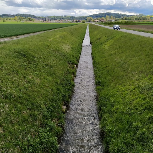
In the 19th and early 20th centuries nearly all Swiss rivers were "corrected" (straightened, channelised and diked) to reduce flood damage and reclaim land for agriculture. In the late 20th century the adverse effects of these corrections became increasingly clear, and there was a paradigm shift towards more sustainable river management. There are many current “revitalization” projects, among them the restoration of the Petite Glâne, which started in 2022 and is expected to be completed in 2026. The project perimeter consists of the last 7 kilometres of the Petite Glâne stream and the costs are estimated at CHF 21.5 million.
The main characteristics of revitalization are widening the riverbed and reducing the slopes of the riverbanks, thus giving the river space for meandering and changing the morphology in a natural way. Where riparian forests do not occur naturally anymore, it can make sense to re-establish them so that biodiversity can flourish. The planting of trees and bushes gives many animals a habitat and can serve as a wildlife corridor between different areas. Additionally, shading of the water reduces its temperature fluctuations which - especially in summer - is important to many species that are dependent on cold water for their survival. With climate change this threat will become even worse. The main purpose of revitalization is to recreate near-natural conditions in artificially straightened reaches to ensure provision of riparian ecosystem services.
Considerable planning is involved in implementing this technology in Switzerland partly because of legal reasons (watercourses are closely protected and land rights require negotiation) and because effects on downstream areas need to be taken into account. Depending on the length of the river segment where riparian forests are to be restored, there are many stakeholders involved, all of whom need to give their approval: this takes time and effort. Inputs are mostly in the form of trees and bushes. Depending on the degree of revitalization, built-up river sections need to be freed again and infrastructure like bridges, buildings and roads may be affected. In theory, there is no maintenance necessary because revitalized rivers are intended to reassume their natural form and be surrounded by natural vegetation. Nevertheless, in a highly modified and intensely used landscape, the cutting of grass and pruning of trees/bushes on a regular basis can be required. Wood harvesting may be an option. Driftwood might also have to be removed if there is danger of flooding or clogging of bottlenecks – for example under bridges.
Revitalization, theoretically, has larger effects on smaller rivers than on bigger ones due to a greater proportion of land draining into them compared to their size. Additionally, shading has larger effects on the water temperature of smaller rivers. Benefits accruing are mainly in regard to habitat provision and thus biodiversity enhancement, but also improvement of water quality (lower temperatures, less nutrient input) and water management in general as flooding is expected to be less frequent. A key disadvantage is that the measures are often implemented at the expense of agricultural land. Naturally, farmers are usually unhappy about the loss of land - even though alternative agricultural plots and direct payments are provided. In general, however, people appreciate the improvement in the quality of life (a pleasanter area for leisure) and improved biodiversity.
ទីតាំង
ទីតាំង: Petite Glâne watershed, 4 communities: Vallon, Missy, St. Aubin, Vully-le-Lac, FR/VD, ប្រទេសស្វ៊ីស
ចំនួនទីកន្លែងបច្ចេកទេស ដែលវិភាគ: មួយកន្លែង
ចំណុចយោងភូមិសាស្ត្រនៃទីតាំងជ្រើសរើស
-
6.95712, 46.87209
-
7.01901, 46.91089
ការសាយភាយនៃបច្ចេកទេស: ត្រូវបានផ្សព្វផ្សាយត្រឹមតំបន់មួយ (approx. 0.1-1 គម2)
តើស្ថិតក្នុងតំបន់ការពារអចិន្ត្រៃយ៍?: ទេ
កាលបរិច្ឆេទនៃការអនុវត្ត: 2022
ប្រភេទនៃការណែនាំឱ្យអនុវត្តន៍៖
-
តាមរយៈការបង្កើតថ្មីរបស់អ្នកប្រើប្រាស់ដី
-
ជាផ្នែកនៃប្រព័ន្ធប្រពៃណី (> 50 ឆ្នាំ)
-
ពេលកំពុងពិសោធន៍
-
តាមរយៈគម្រោង / អន្តរាគមន៍ពីខាងក្រៅ
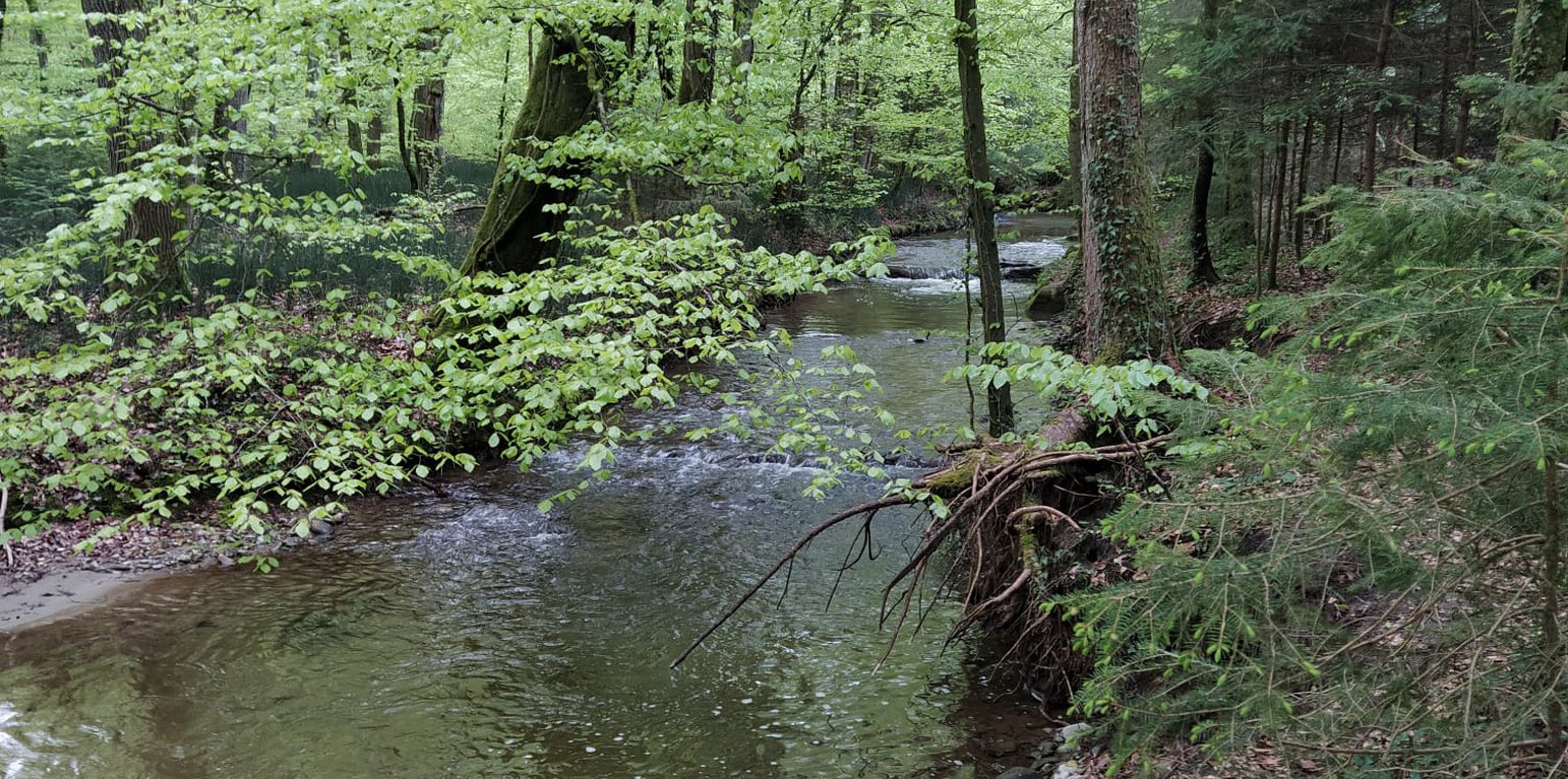
Reach of the Petite Glâne before the implementation of riparian forests (and revitalization of the streambed) (Nives Ramisberger)
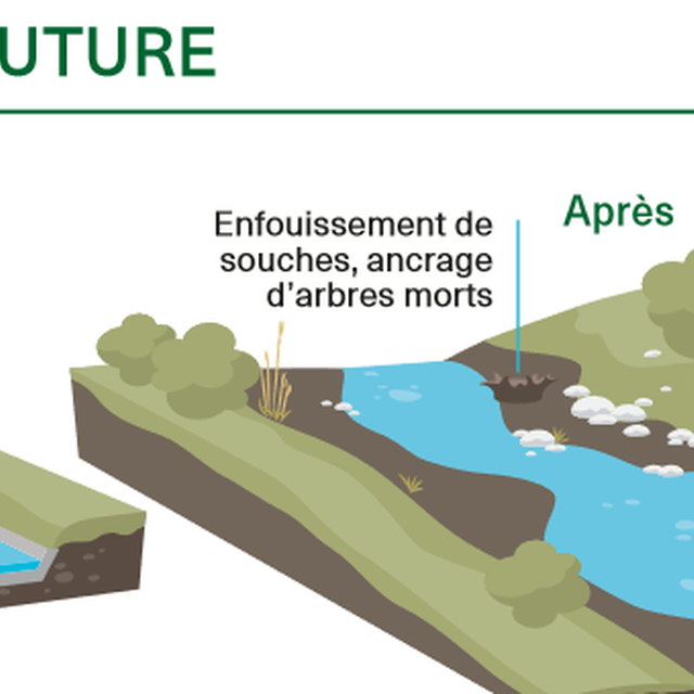
Baseline situation (now) and how it is intended to look after the implementation of the revitalization (Associadion Intercommunale Petite Glâne: La Petite Glâne - de Vallon à Vully-les-Lacs - Revitalisation 2020-2030)
គោលបំណងចម្បងៗ
-
ធ្វើឱ្យប្រសើរឡើងនូវផលិតកម្ម
-
កាត់បន្ថយ, បង្ការ, ស្តារឡើងវិញនូវការធ្លាក់ចុះគុណភាពដី
-
អភិរក្សប្រព័ន្ធអេកូឡូស៊ី
-
ការពារតំបន់ទីជម្រាល/តំបន់ខ្សែទឹកខាងក្រោមបញ្ចូលជាមួយបច្ចេកទេសផ្សេងទៀត
-
អភិរក្ស/ធ្វើឱ្យប្រសើរឡើងជីវចម្រុះ
-
កាត់បន្ថយហានិភ័យនៃគ្រោះមហន្តរាយ
-
បន្ស៊ាំទៅនឹងការប្រែប្រួលអាកាសធាតុ/គ្រោះមហន្តរាយ និងផលប៉ះពាល់របស់វា
-
កាត់បន្ថយការប្រែប្រួលអាកាសធាតុ និងផលប៉ះពាល់របស់វា
-
បង្កើតផលប្រយោជន៍សេដ្ឋកិច្ច
-
បង្កើតផលប្រយោជន៍សង្គម
ការប្រើប្រាស់ដី
ដីប្រើប្រាស់ចម្រុះនៅលើដីតែមួយ ទេ
-
ដីព្រៃ/ដីដាំដើមឈើ
- ព្រៃ (ពាក់កណ្តាល) ធម្មជាតិ/ ដីព្រៃ
- ការដាំដើមឈើ ការដាំព្រៃឡើងវិញ. ពូជ៖ពូជបញ្ចូលគ្នា
Tree types (ព្រៃល្បោះ): មិនមាន
ផលិតផល និងសេវាកម្ម: ការអភិរក្ស/ការការពារធម្មជាតិ, ការកំសាន្ត/ទេសចរណ៍, ការពារពីគ្រោះធម្មជាតិ
-
ផ្លូវទឹក ផ្ទៃទឹក ដីសើម - ខ្សែទឹក ផ្លូវទឹក
ការផ្គត់ផ្គង់ទឹក
-
ទឹកភ្លៀង
-
ទឹកភ្លៀង និងប្រព័ន្ធស្រោចស្រព
-
ប្រព័ន្ធស្រោចស្រពទាំងស្រុង
គោលបំណងទាក់ទងនឹងការធ្លាក់ចុះគុណភាពដី
-
ការការពារការធ្លាក់ចុះគុណភាពដី
-
ការកាត់បន្ថយការធ្លាក់ចុះគុណភាពដី
-
ការជួសជុល/ ស្តារឡើងវិញនៃឱនភាពដីធ្ងន់ធ្ងរ
-
ការបន្ស៊ាំទៅនឹងការធ្លាក់ចុះគុណភាពដី
-
ដែលមិនអាចអនុវត្តបាន
ប្រភេទនៃការធ្លាក់ចុះគុណភាពដីដែលបានដោះស្រាយ
-
ការហូរច្រោះដីដោយសារទឹក - Wr: សំណឹកដីច្រាំងទន្លេ
-
ការធ្លាក់ចុះជីវសាស្ត្រនៃដី - Bh: ការបាត់បង់ទីជំរក, Bs: សមាសភាពដែលមានគុណភាពនិងប្រភេទសត្វ/ការថយចុះនូវជីវចម្រុះ
-
ការបាត់បង់ទឹក - Hs: ការប្រែប្រួលបរិមាណទឹកនៅលើផ្ទៃដី, Hp: ការថយចុះគុណភាពទឹកនៅលើផ្ទៃដី
ក្រុម SLM
-
ការគ្រប់គ្រងព្រៃធម្មជាតិ និងព្រៃពាក់កណ្តាលធម្មជាតិ
-
ការគ្រប់គ្រងទឹកលើដី (ទឹកធ្លាក់ ទន្លេ បឹង សមុទ្រ)
-
កាត់បន្ថយហានិភ័យនៃបញ្ហាលើប្រព័ន្ធអេកូឡូស៊ី
វិធានការ SLM
-
វិធានការរុក្ខជាតិ - V1: ឈើធំៗ និងដើមឈើតូចៗ
-
វិធានការរចនាស័ម្ពន្ធ - S2: ភ្លឺ ច្រាំង
-
វិធានការគ្រប់គ្រង - M1: ការផ្លាស់ប្តូរប្រភេទដីប្រើប្រាស់, M2: ការផ្លាស់ប្តូរការគ្រប់គ្រង/ កម្រិតអាំងតង់ស៊ីតេ
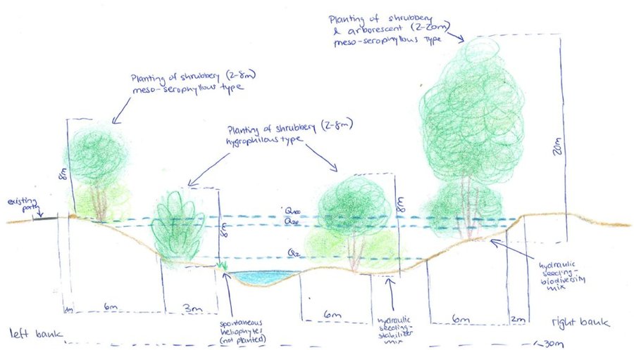
គំនូរបច្ចេកទេស
លក្ខណៈបច្ចេកទេស
Between 2022 and 2026, the Petite Glâne is being revitalized on a length of 7 km with an average enlargement of the riparian zone of 15 m which totals in the riparian zone having a width between 35 and 60 m. 30,000 young trees and shrubs (from 37 species) and 100 larger trees are being planted. In addition, 200 small structures for wildlife will be provided. The very steep riverbanks are being reduced in their slope. Material used for the reconstruction of the river mainly comprises vegetation.
Author: Nives Ramisberger
ការបង្កើតនិងការថែទាំ៖ សកម្មភាព ធាតុចូល និងថ្លៃដើម
ការគណនាធាតុចូល និងថ្លៃដើម
- ថ្លៃដើមត្រូវបានគណនា៖ ក្នុងតំបន់អនុវត្តបច្ចេកទេស (ទំហំ និងឯកត្តាផ្ទៃដី៖ 33 ha (medium width of riparian area ((35+60)/2) * length of river reach (7km)))
- រូបិយប័ណ្ណសម្រាប់ការគណនាថ្លៃដើម៖ CHF
- អត្រាប្តូរប្រាក់ (ទៅជាដុល្លារអាមេរិក)៖ 1 USD = 0.98 CHF
- ថ្លៃឈ្នួលជាមធ្យមក្នុង ១ ថ្ងៃ៖ មិនមាន
កត្តាសំខាន់បំផុតដែលមានឥទ្ធិពលលើថ្លៃដើម
The most expensive feature of this project is the volume of earth that will be removed from the now steep riverbanks to widen the riverbed. The earth removed will directly be used again for small hills and what is not used directly in the riparian zone will be distributed on the agriculturally used fields next to the rivers. Also, there are several bridges that cross the Petite Glâne, and by enlarging the riverbed the bridges need to be rebuilt as well - which drives up the price greatly.
សកម្មភាពបង្កើតបច្ចេកទេស
-
communication (with communities etc.) and looking for sponsoring (ពេលវេលា/ ភាពញឹកញាប់: 2018)
-
completion of studies (ពេលវេលា/ ភាពញឹកញាប់: 2018)
-
survey/planning/project execution (ពេលវេលា/ ភាពញឹកញាប់: 2018)
-
Delays due to the Corona pandemic, start of reconstruction was originally planned for 2020 (ពេលវេលា/ ភាពញឹកញាប់: None)
-
search for company (ពេលវេលា/ ភាពញឹកញាប់: 2022)
-
implementation (ពេលវេលា/ ភាពញឹកញាប់: 2022-2025)
ធាតុចូល និងថ្លៃដើមសម្រាប់ការបង្កើតបច្ចេកទេស
| បញ្ជាក់ពីធាតុចូល |
ឯកតា |
បរិមាណ |
ថ្លៃដើមក្នុងមួយឯកតា (CHF) |
ថ្លៃធាតុចូលសរុប (CHF) |
% នៃថ្លៃដើមដែលចំណាយដោយអ្នកប្រើប្រាស់ដី |
|
កម្លាំងពលកម្ម
|
| engineers, purchase of land |
|
1,0 |
3000000,0 |
3000000,0 |
|
|
សម្ភារៈដាំដុះ
|
| trees, small structures |
|
30000,0 |
100,0 |
3000000,0 |
|
|
សម្ភារៈសាងសង់
|
| terracing, bridges |
|
1,0 |
15000000,0 |
15000000,0 |
|
|
ផ្សេងៗ
|
| unexpected |
|
1,0 |
500000,0 |
500000,0 |
|
| ថ្លៃដើមសរុបក្នុងការបង្កើតបច្ចេកទេស |
21'500'000.0 |
|
| ថ្លៃដើមសរុបក្នុងការបង្កើតបច្ចេកទេសគិតជាដុល្លារ |
21'938'775.51 |
|
សកម្មភាពថែទាំ
-
Checking riverbed (ពេលវេលា/ ភាពញឹកញាប់: every 2-3 years)
-
Mowing of grass (ពេលវេលា/ ភាពញឹកញាប់: 1-2 per year)
-
Cutting/ pruning of trees (ពេលវេលា/ ភាពញឹកញាប់: every 5-10 years (usually around 30% of the area at once))
-
General maintenance period (ពេលវេលា/ ភាពញឹកញាប់: 2025-2028)
-
Follow-up, control of revitalization effects (ពេលវេលា/ ភាពញឹកញាប់: 2038)
បរិស្ថានធម្មជាតិ
បរិមាណទឹកភ្លៀងជាមធ្យមប្រចាំឆ្នាំ
-
< 250 មម
-
251-500 មម
-
501-750 មម
-
751-1,000 មម
-
1,001-1,500 មម
-
1,501-2,000 មម
-
2,001-3,000 មម
-
3,001-4,000 មម
-
> 4,000 មម
តំបន់កសិអាកាសធាតុ
-
សើម
-
មានភ្លៀងមធ្យម
-
មានភ្លៀងតិចតួច
-
ស្ងួត
លក្ខណៈសម្គាល់នៃអាកាសធាតុ
បរិមាណទឹកភ្លៀងជាមធ្យមប្រចាំឆ្នាំគិតជា មម៖ 865.0
ស្ថានីយឧតុនិយម៖ Payerne
average maximum temperature 14.2°C, average minimum temperature 5.1°C
ជម្រាល
-
រាបស្មើ (0-2%)
-
ជម្រាលតិចតួច (3-5%)
-
មធ្យម (6-10%)
-
ជម្រាលខ្ពស់បន្តិច (11-15%)
-
ទីទួល (16-30%)
-
ទីទួលចោត (31-60%)
-
ទីទួលចោតខ្លាំង (>60%)
ទម្រង់ដី
-
ខ្ពង់រាប
-
កំពូលភ្នំ
-
ជម្រាលភ្នំ
-
ជម្រាលទួល
-
ជម្រាលជើងភ្នំ
-
បាតជ្រលងភ្នំ
រយៈកម្ពស់ធៀបនឹងនីវ៉ូទឹកសមុទ្រ
-
0-100 ម
-
101-500 ម
-
501-1,000 ម
-
1,001-1,500 ម
-
1,501-2,000 ម
-
2,001-2,500 ម
-
2,501-3,000 ម
-
3,001-4,000 ម
-
> 4,000 ម
បច្ចេកទេសត្រូវបានអនុវត្តនៅក្នុង
-
សណ្ឋានដីប៉ោង
-
សណ្ឋានដីផត
-
មិនពាក់ព័ន្ធទាំងអស់
ជម្រៅដី
-
រាក់ខ្លាំង (0-20 សម)
-
រាក់ (21-50 សម)
-
មធ្យម (51-80 សម)
-
ជ្រៅ (81-120 សម)
-
ជ្រៅខ្លាំង (> 120 សម)
វាយនៈភាពដី (ដីស្រទាប់ខាងលើ)
-
គ្រើម/ មានពន្លឺ (ខ្សាច់)
-
មធ្យម (ល្បាយ, ល្បាប់)
-
ម៉ត់/ ធ្ងន់ (ឥដ្ឋ)
វាយនភាពដី (> 20 សម ក្រោមស្រទាប់លើ)
-
គ្រើម/ មានពន្លឺ (ខ្សាច់)
-
មធ្យម (ល្បាយ, ល្បាប់)
-
ម៉ត់/ ធ្ងន់ (ឥដ្ឋ)
កម្រិតសារធាតុសរីរាង្គក្នុងដីស្រទាប់លើ
-
ខ្ពស់ (>3%)
-
មធ្យម (1-3%)
-
ទាប (<1%)
ដង្ហើមទឹកក្នុងដី
-
ផ្ទៃខាងលើ
-
< 5 ម
-
5-50 ម
-
> 50 ម
ភាពអាចរកបាននៃទឹកលើដី
-
លើស
-
ល្អ
-
កម្រិតមធ្យម
-
មិនមាន/ គ្មាន
គុណភាពទឹក (មិនបានធ្វើប្រព្រឹត្តិកម្ម)
-
ទឹកពិសារដែលមានគុណភាពល្អ
-
ទឹកពិសារដែលគ្មានគុណភាព (តម្រូវឱ្យមានការសំអាត)
-
ទឹកសម្រាប់តែការធ្វើកសិកម្ម (ស្រោចស្រព)
-
ទឹកមិនអាចប្រើប្រាស់បាន
គុណភាពទឹក គឺផ្តោតទៅលើ៖ ទឹកលើផ្ទៃដី
តើមានបញ្ហាទឹកប្រៃហូរចូលដែរឬទេ?
ការកើតឡើងនៃទឹកជំនន់
ភាពសំបូរបែបនៃជម្រកធម្មជាតិ
ចរិតលក្ខណៈរបស់អ្នកប្រើប្រាស់ដីដែលប្រើបច្ចេកទេស SLM
ទីផ្សារ
-
សម្រាប់ហូបក្នុងគ្រួសារ (ផ្គត់ផ្គង់ខ្លួនឯង)
-
ពាក់កណ្តាលពាណិជ្ជកម្ម (ផ្គត់ផ្គង់ខ្លួនឯង/ ពាណិជ្ជកម្ម)
-
ពាណិជ្ជកម្ម/ ទីផ្សារ
ចំណូលក្រៅកសិដ្ឋាន
-
តិចជាង 10% នៃចំណូល
-
10-50% នៃចំណូល
-
ច្រើនជាង 50% នៃចំណូល
កម្រិតជីវភាព
-
មិនល្អខ្លាំង
-
មិនល្អ
-
មធ្យម
-
មាន
-
មានខ្លាំង
កម្រិតនៃការប្រើគ្រឿងយន្ត
-
ប្រើកម្លាំងពលកម្ម
-
ប្រើកម្លាំងសត្វ
-
គ្រឿងយន្ត/ ម៉ាស៊ីន
នៅមួយកន្លែង ឬពនេចរ
-
នៅមួយកន្លែង
-
ពាក់កណ្តាលពនេចរ
-
ពនេចរ
បុគ្គល ឬក្រុម
-
ធ្វើខ្លួនឯង/ គ្រួសារ
-
ជាក្រុម/ សហគមន៍
-
សហករ
-
មានបុគ្គលិក (ក្រុមហ៊ុន, រដ្ឋ)
អាយុ
-
កុមារ
-
យុវវ័យ
-
វ័យកណ្តាល
-
មនុស្សចាស់
ផ្ទៃដីប្រើប្រាស់ក្នុងមួយគ្រួសារ
-
< 0.5 ហិកតា
-
0.5-1 ហិកតា
-
1-2 ហិកតា
-
2-5 ហិកតា
-
5-15 ហិកតា
-
15-50 ហិកតា
-
50-100 ហិកតា
-
100-500 ហិកតា
-
500-1,000 ហិកតា
-
1,000-10,000 ហិកតា
-
> 10,000 ហិកតា
មាត្រដ្ឋាន
-
ខ្នាតតូច
-
ខ្នាតមធ្យម
-
ខ្នាតធំ
ភាពជាម្ចាស់ដីធ្លី
-
រដ្ឋ
-
ក្រុមហ៊ុន
-
ភូមិ
-
ក្រុម
-
ឯកជន មិនមានកម្មសិទ្ធ
-
ឯកជន មានកម្មសិទ្ធ
សិទ្ធិប្រើប្រាស់ដី
-
អាស្រ័យផលសេរី (មិនមានការកំណត់)
-
ជាក្រុម (មានដែនកំណត់)
-
កិច្ចសន្យាជួល
-
ឯកជន
សិទ្ធិប្រើប្រាស់ទឹក
-
អាស្រ័យផលសេរី (មិនមានការកំណត់)
-
ជាក្រុម (មានដែនកំណត់)
-
កិច្ចសន្យាជួល
-
ឯកជន
ប្រើប្រាស់សេវាកម្ម និងហេដ្ឋារចនាសម្ព័ន្ធ
ការងារ (ឧ. ការងារក្រៅកសិដ្ឋាន)
ផលប៉ះពាល់
ផលប៉ះពាល់សេដ្ឋកិច្ចសង្គម
ទំហំផ្ទៃដីផលិតកម្ម (ដីថ្មីដែលបានដាំដុះ/ ប្រើប្រាស់)
ទឹកប្រើប្រាស់សម្រាប់ស្រោចស្រព
ចំណូលក្នុងកសិដ្ឋាន
In the short term it is expected to decrease due to loss of land, in the long term not because of more resilience towards floods
ភាពសម្បូរបែបប្រភពប្រាក់ចំណូល
State subsidies for biodiversity areas
ផលប៉ះពាល់វប្បធម៌សង្គម
កម្មសិទ្ធដីប្រើប្រាស់/ ទឹក
អាក្រក់ជាងមុន
ប្រសើរជាងមុន
ឱកាសវប្បធម៌ (ឧ. វិញ្ញាណ សាភ័ណភាព ផ្សេងទៀត)
ឱកាសនៃការបង្កើតថ្មី
The landscape becomes more beautiful and new places to stay are made, but on the other hand many places are deliberately made inaccessible for the protection of flora & fauna.
ការកាត់បន្ថយជម្លោះ
អាក្រក់ជាងមុន
ប្រសើរជាងមុន
Simultaneously, the threat of flooding for farmers is decreased and enhancement of habitat created which is expected to lead to improved acceptance by all stakeholders
ផលប៉ះពាល់លើអេកូឡូស៊ី
ការប្រមូលទឹក (លំហូរ ទឹកសន្សើម ព្រិល ។ល។)
លំហូរទឹកលើផ្ទៃដី
Will be slightly improved through reducing the gradient of riverbanks
នីវ៉ូទឹកក្រោមដី/ ដង្ហើមទឹក
រំហួត
Less evaporation but more evapotranspiration expected
ប្រភេទមានប្រយោជន៍ (មំសាសី ជន្លេន ពពួកសត្វចម្លងលម្អង)
ផលប៉ះពាល់នៃគ្រោះរាំងស្ងួត
It is not known yet if there will be any difference for after the implementation but it is expected that the difference will be negligible
ផលប៉ះពាល់នៃព្យុះស៊ីក្លូន/ព្យុះភ្លៀង
ការបំភាយនៃកាបូន និងឧស្ម័នផ្ទះកញ្ចក់
អាកាសធាតុ
អាក្រក់ជាងមុន
ប្រសើរជាងមុន
ផលប៉ះពាល់ក្នុងបរិវេណ
ទឹកដែលអាចទាញមកប្រើប្រាស់បាន (ទឹកក្រោមដី ទឹក-springs)
លំហូរទឹកថេរនិងទៀតទាត់នៅរដូវប្រាំង (រាប់ទាំងលំហូរតិចៗ)
ទឹកជំនន់ខ្សែទឹកខាងក្រោម (មិនត្រូវការ)
កំណកល្បាប់ខ្សែទឹកខាងក្រោម
ទឹកក្រោមដី/ ការបំពុលទឹកទន្លេ
សមត្ថភាពចម្រោះ (ដោយដី ដំណាំ ដីសើម)
ខូចខាតដល់ហេដ្ឋារចនាសម្ព័ន្ធសាធារណៈ/ឯកជន
ការវិភាគថ្លៃដើម និងអត្ថប្រយោជន៍
អត្ថប្រយោជន៍បើប្រៀបធៀបនឹងថ្លៃដើមក្នុងការបង្កើតបច្ចេកទេស
រយៈពេលខ្លី
អវិជ្ជមានខ្លាំង
វិជ្ជមានខ្លាំង
រយៈពេលវែង
អវិជ្ជមានខ្លាំង
វិជ្ជមានខ្លាំង
អត្ថប្រយោជន៍បើប្រៀបធៀបនឹងថ្លៃដើមក្នុងការថែទាំបច្ចេកទេស
រយៈពេលខ្លី
អវិជ្ជមានខ្លាំង
វិជ្ជមានខ្លាំង
រយៈពេលវែង
អវិជ្ជមានខ្លាំង
វិជ្ជមានខ្លាំង
ការប្រែប្រួលអាកាសធាតុ
ការប្រែប្រួលអាកាសធាតុ
សីតុណ្ហភាពប្រចាំឆ្នាំ កើនឡើង
គ្រោះអាកាសធាតុ (មហន្តរាយ)
ការទទួលយក និងការបន្ស៊ាំ
ភាគរយនៃអ្នកប្រើប្រាស់ដីនៅតំបន់ដែលបានទទួលយកបច្ចេកទេស
-
តែមួយករណី /ពិសោធន៍
-
1-10%
-
11-50%
-
> 50%
ក្នុងចំណោមអ្នកទទួលយកបច្ចេកទេសនេះ តើមានប៉ុន្មានភាគរយដែលបានអនុវត្តន៍ដោយមិនបានទទួលការលើកទឹកចិត្តជាសម្ភារៈ?
-
0-10%
-
11-50%
-
51-90%
-
91-100%
តើថ្មីៗនេះ បច្ចេកទេសនេះត្រូវបានកែតម្រូវដើម្បីបន្ស៊ាំទៅនឹងស្ថានភាពប្រែប្រួលដែរឬទេ?
ចំពោះលក្ខខណ្ឌប្រែប្រួលណាមួយដែលត្រូវបានបន្ស៊ាំ?
-
ការប្រែប្រួលអាកាសធាតុ/គ្រោះមហន្តរាយធម្មជាតិ
-
បម្រែបម្រួលទីផ្សារ
-
កម្លាំងពលកម្មដែលអាចរកបាន (ចំណាកស្រុក)
សេក្តីសន្និដ្ឋាន និងមេរៀនបទពិសោធន៍
ភាពខ្លាំង: ទស្សនៈអ្នកប្រើប្រាស់ដី
-
Less flooding
-
Small improvement in soil quality
ភាពខ្លាំង: ទស្សនៈរបស់អ្នកចងក្រង ឬបុគ្គលសំខាន់ផ្សេងទៀត
-
Biodiversity
-
Positive measure against warming waters
-
Improvement of the landscape and therefore of the quality for recreational purposes
-
Flood protection
ចំណុចខ្សោយ/ គុណវិបត្តិ/ ហានិភ័យ : ទស្សនៈអ្នកប្រើប្រាស់ដីវិធីដោះស្រាយ
-
Loss of agricultural land
Exchange of plots (next to river taken; elsewhere, another given)
Financial compensation
ចំណុចខ្សោយ/ គុណវិបត្តិ/ ហានិភ័យ : ទស្សនៈរបស់អ្នកចងក្រង ឬបុគ្គលសំខាន់ផ្សេងទៀតវិធីដោះស្រាយ
-
High costs
Sponsoring/subsidies needed
ឯកសារយោង
Editors
-
Joana Eichenberger
-
Tatenda Lemann
-
Nadja Kollbrunner
អ្នកត្រួតពិនិត្យ
-
Rima Mekdaschi Studer
-
William Critchley
កាលបរិច្ឆេទនៃការអនុវត្ត: 28 ខែ មេសា ឆ្នាំ 2022
កែតម្រូវចុងក្រោយ: 21 ខែ កុម្ភៈ ឆ្នាំ 2025
បុគ្គលសំខាន់ៗ
-
Julien Devanthéry - អ្នកជំនាញឯកទេស SLM
-
Audrey Friedli - អ្នកជំនាញឯកទេស SLM
ការពណ៌នាលម្អិតក្នុងប្រព័ន្ធគ្រប់គ្រងទិន្នន័យរបស់វ៉ូខេត
ឯកសារនេះត្រូវបានសម្របសម្រួលដោយ
ស្ថាប័ន៖
- CDE Centre for Development and Environment (CDE Centre for Development and Environment) - ប្រទេសស្វ៊ីស
- University of Bern, Institute of Geography (GIUB) - ប្រទេសស្វ៊ីស
គម្រោង
- OPtimal strategies to retAIN and re-use water and nutrients in small agricultural catchments across different soil-climatic regions in Europe (OPTAIN)