Grass buffer zones alongside waterways in cropland [ប្រទេសន័រវែស]
- ការបង្កើត៖
- បច្ចុប្បន្នភាព
- អ្នកចងក្រង៖ Kamilla Skaalsveen
- អ្នកកែសម្រួល៖ Anne-Grete Buseth Blankenberg, Dominika Krzeminska, Zhanguo Bai
- អ្នកត្រួតពិនិត្យច្រើនទៀត៖ Rima Mekdaschi Studer, William Critchley
Grasdekt buffersone
technologies_1656 - ប្រទេសន័រវែស
- សង្ខេបជា PDF
- សេចក្តីសង្ខេបពេញលេញជាទម្រង់ PDF សម្រាប់បោះពុម្ព
- សេចក្តីសង្ខេបពេញលេញទម្រង់អ៊ីនធឺនេត
- សេចក្តីសង្ខេបពេញលេញ (មិនមានទម្រង់ជាក់លាក់)
- Grass buffer zones alongside waterways in cropland: 3 ខែ កុម្ភៈ ឆ្នាំ 2023 (public)
- Grass buffer zones alongside waterways in cropland: 17 ខែ មិថុនា ឆ្នាំ 2022 (inactive)
- Grass Covered Riparian Buffer Strips: 5 ខែ កញ្ញា ឆ្នាំ 2019 (inactive)
- Grass Covered Riparian Buffer Strips: 16 ខែ មិនា ឆ្នាំ 2017 (inactive)
- Grass Covered Riparian Buffer Strips: 16 ខែ មិនា ឆ្នាំ 2017 (inactive)
ពិនិត្យមើលគ្រប់ផ្នែក
ពង្រីកមើលទាំងអស់ បង្រួមទាំងអស់1. ព័ត៌មានទូទៅ
1.2 ព័ត៌មានលម្អិតពីបុគ្គលសំខាន់ៗ និងស្ថាប័នដែលចូលរួមក្នុងការវាយតម្លៃ និងចងក្រងឯកសារនៃបច្ចេកទេស
អ្នកជំនាញឯកទេស SLM:
អ្នកជំនាញឯកទេស SLM:
ឈ្មោះគម្រោងដែលបានចងក្រងឯកសារ/ វាយតម្លៃលើបច្ចេកទេស (បើទាក់ទង)
OPtimal strategies to retAIN and re-use water and nutrients in small agricultural catchments across different soil-climatic regions in Europe (OPTAIN)ឈ្មោះគម្រោងដែលបានចងក្រងឯកសារ/ វាយតម្លៃលើបច្ចេកទេស (បើទាក់ទង)
Preventing and Remediating degradation of soils in Europe through Land Care (EU-RECARE )ឈ្មោះអង្គភាពមួយ (ច្រើន) ដែលបានចងក្រងឯកសារ/ វាយតម្លៃបច្ចេកទេស (បើទាក់ទង)
Norwegian Institute for Agricultural and Environme (Norwegian Institute for Agricultural and Environme) - ប្រទេសន័រវែស1.3 លក្ខខណ្ឌទាក់ទងទៅនឹងការប្រើប្រាស់ទិន្នន័យដែលបានចងក្រងតាមរយៈ វ៉ូខេត
អ្នកចងក្រង និង(បុគ្គលសំខាន់ៗ)យល់ព្រមទទួលយកនូវលក្ខខណ្ឌនានាទាក់ទងទៅនឹងការប្រើប្រាស់ទិន្នន័យដែលបានចងក្រងតាមរយៈវ៉ូខេត:
បាទ/ចា៎
1.4 សេចក្តីប្រកាសស្តីពីចីរភាពនៃការពណ៌នាពីបច្ចេកទេស
តើបច្ចេកទេសដែលបានពណ៌នានេះមានបញ្ហាដែលផ្តោតលើការធ្លាក់ចុះគុណភាពដី, បើដូច្នេះវាមិនអាចត្រូវបានប្រកាសថាជាបច្ចេកទេសនៃការគ្រប់គ្រងប្រកបដោយចីរភាពទេ?
ទេ
1.5 ការយោងទៅលើកម្រងបញ្ជីសំណួរ (មួយ ឬច្រើន) នៃវិធីសាស្ត្រផ្សព្វផ្សាយ SLM (ដែលបានចងក្រងដោយទស្សនៈពិភពលោកស្តីពីវិធីសាស្ត្រ និងបច្ចេកទេសងអភិរក្ស WOCAT)

Regional Environmental program [ប្រទេសន័រវែស]
Regulations and financial grants for reduction of pollution and promotion of the cultural landscape.
- អ្នកចងក្រង៖ Kamilla Skaalsveen
2. ការពណ៌នាពីបច្ចេកទេស SLM
2.1 ការពណ៌នាដោយសង្ខេបពីបច្ចេកទេស
និយមន័យបច្ចេកទេស:
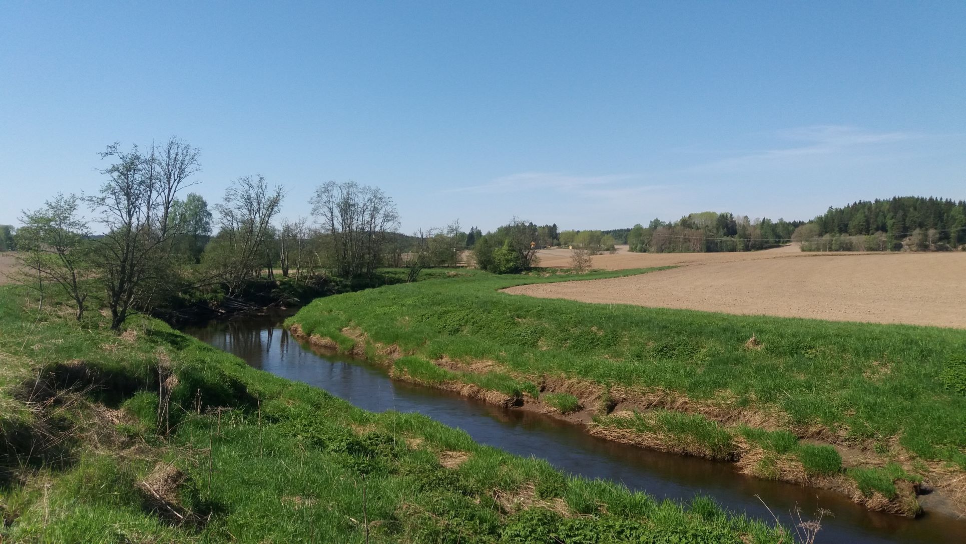
Grass buffer zones are established along waterways in cropland to reduce the surface runoff rate, and the amounts of sediment, nutrients and pesticides in the runoff.
2.2 ការពណ៌នាលម្អិតពីបច្ចេកទេស
ការពណ៌នា:
Commonly used names: buffer zones, buffer strips, riparian buffers
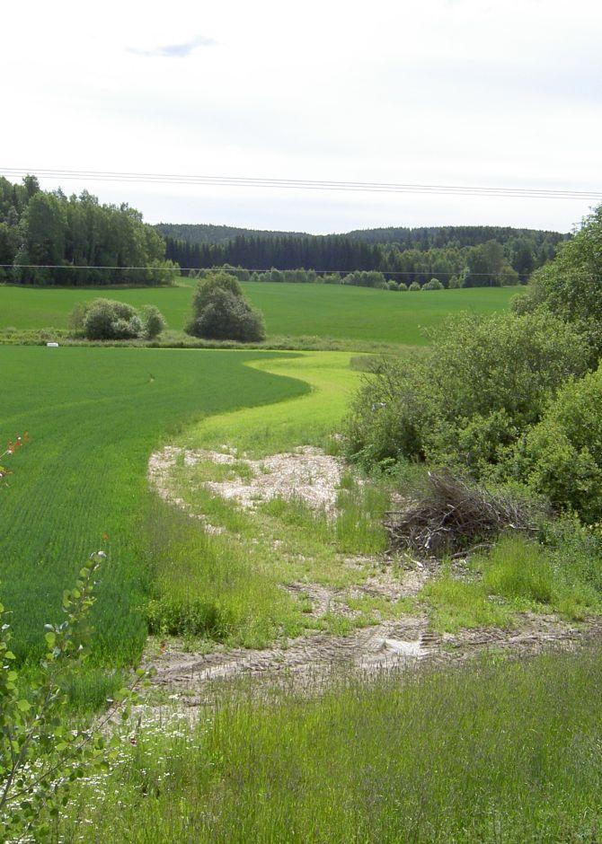
Purpose/aim: Vegetative buffers are areas of permanent vegetation located within and between agricultural fields and the watercourses to which they drain. The purpose of the vegetative buffer is to intercept, and reduce the rates of surface runoff and to reduce loads of sediment, nutrients and pesticide delivered to waterways. The processes involved are filtration, sedimentation, infiltration and absorption. Reducing the input of particles and nutrients into surface waterways is desirable both to improve water quality and to prevent eutrophication of downstream water bodies. In Norway, buffer zones are primarily established to reduce surface runoff of particles and phosphorus. However, vegetation in these zones can also serve other useful functions, such as protection against bank erosion, production of biomass, and/or provision of habitats for wildlife.
Establishment/maintenance activities:
Buffer zones are most commonly designed to retain inputs of nutrients and particles from adjacent fields. Vegetative buffers may be constructed or naturally vegetated, within or alongside fields, or adjacent to drainage ditches, streams, lakes, ponds, and wetlands. The buffer zones may consist of grass for fodder production, or be natural vegetation composed of herbs, weeds, bushes and trees.
In Norway, farmers receive subsidies when the area is still used for production, e.g. grass production for fodder. Farmers leave a strip in cropland for grass and herbs to grow alongside rivers, streams and lakes that intersect their cropland areas. It is recommended to sow grass when establishing grass buffer zones. Robust and dense grass types with a high uptake of nutrients are often the best suited for the purpose. The grass strips should generally not be ploughed, fertilized or treated by herbicides, but some exceptions may be made. The degree to which the grass is harvested varies with the grass type and if it is valuable for livestock fodder.
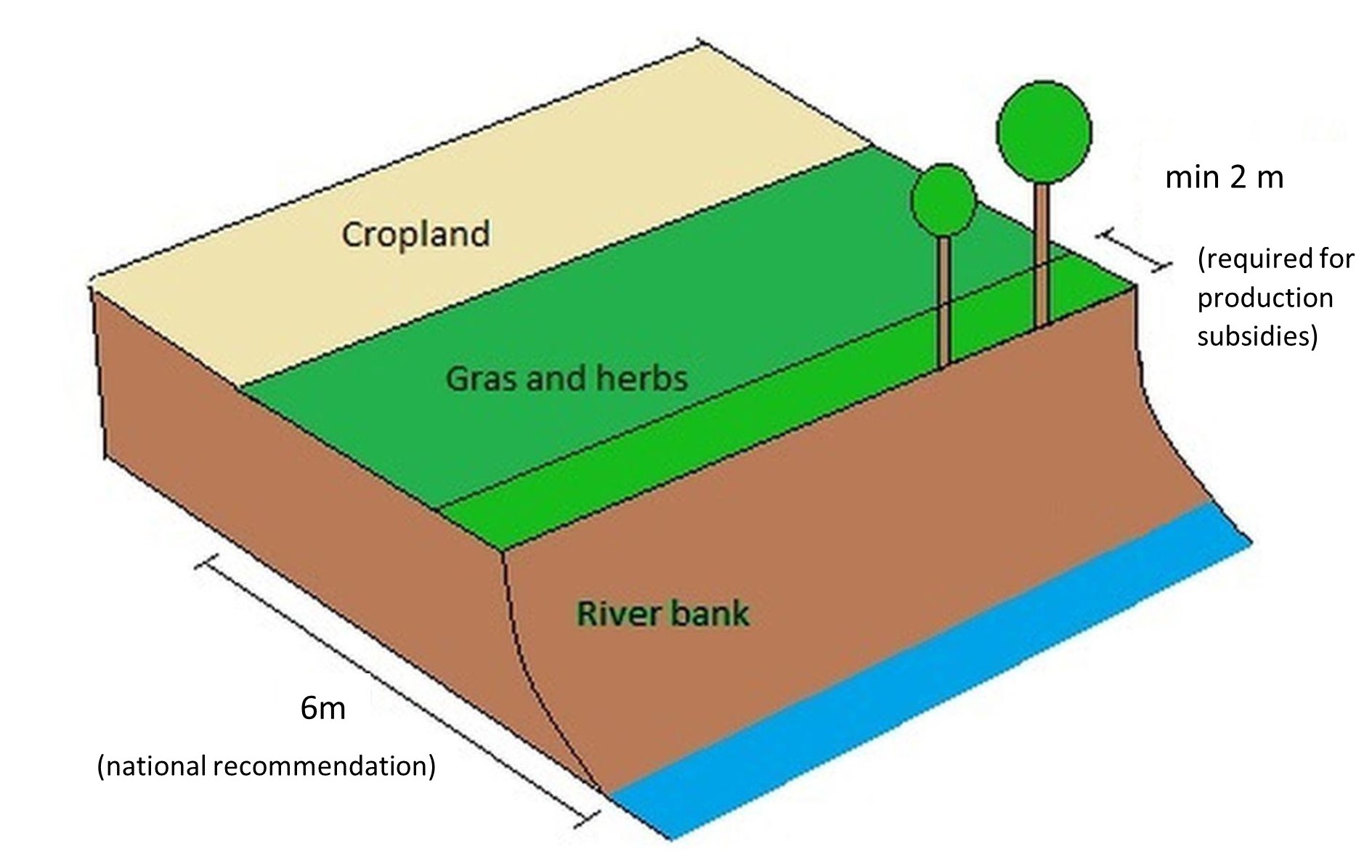
Buffer zones are one of the most common measures in Norway, and the requirements for the dimension of buffer zones have changed with time - and depend on the region. According to current regulations, buffer zones between the field and the watercourse have to be a minimum of 2 meters in order to qualify for production subsidies (PT-forskriften, § 4). In addition, there is a national recommendation (RMP) to maintain a minimum 6-metre wide buffer zone along all watercourses. However, regional guidelines (RMP) can differ from national ones and the width recommendation differ from county to county.
Benefits/impact: The effectiveness of buffer zones in retaining nutrients and soil particles has been explored by many authors. Retention capacity for phosphorus in buffer zones depends on several factors including vegetation, soil type, slope, hydrological conditions, and the width of the zone. There are large variations in the effectiveness of buffer zones: 32-91% retention of sediment, 26-100% retention of phosphorus and 0-100% retention of nitrogen. The retention effect of grass buffer zones along the Hobøl River, measured with rainfall simulation experiments under the BUFFERKLIMA project (Krzeminska et al., 2020), was: 86-94% for sediment, 86-86% for phosphorus and 78-89% for nitrogen.
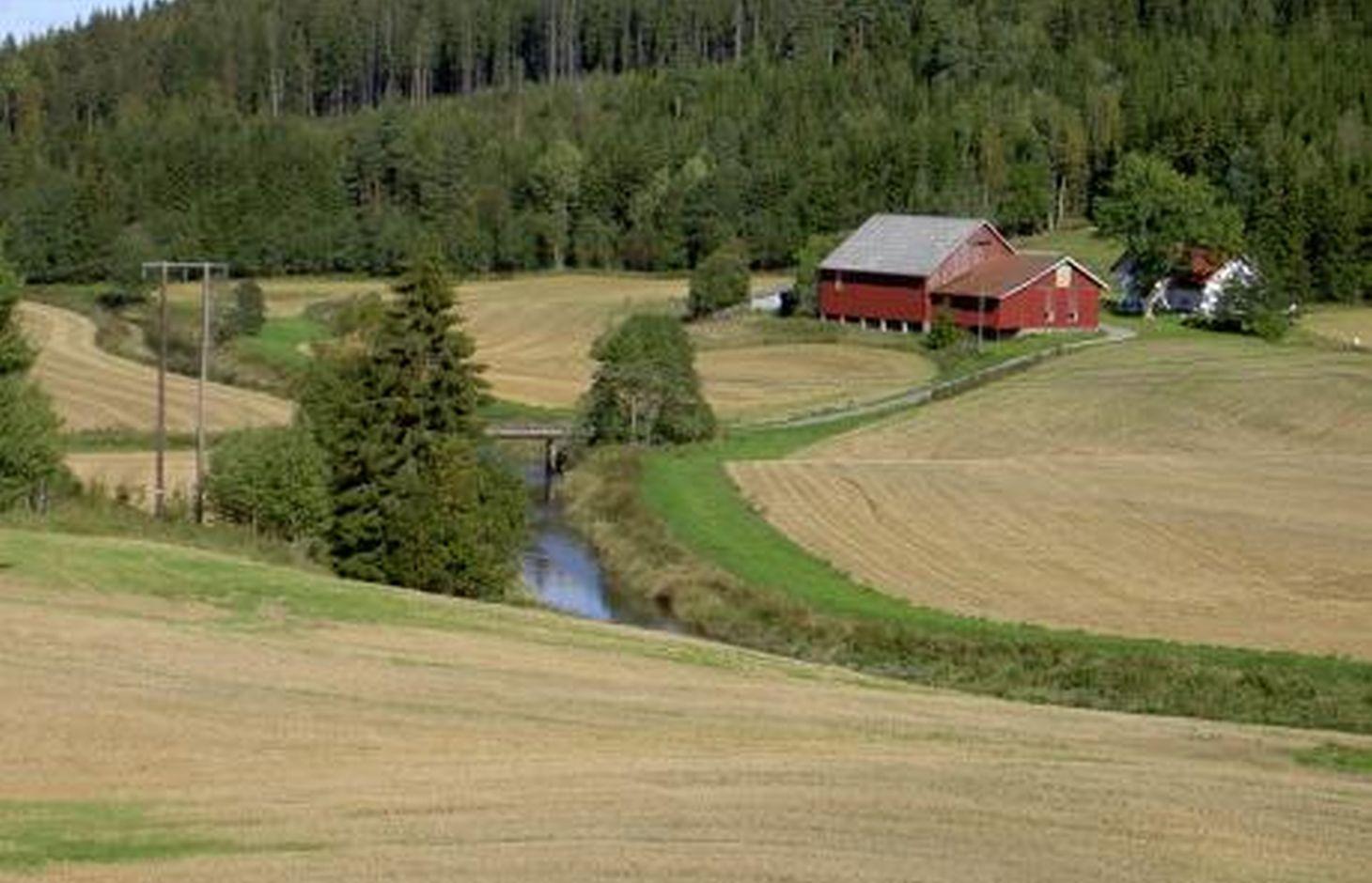
Natural / human environment: The information about this Technology is based on investigations and/or reports from different part of Norway. For the purpose of the OPTAIN project, the technology is further presented in the natural and human environment context of the Kråkstad River catchment - a Norwegian Case Study catchment within the project.
The Kråkstad River is mainly situated in the Ski municipality in the South-Eastern part of Norway. The river catchment is a western tributary of the Vansjø-Hobøl watercourse, also known as the Morsa watercourse. The Kråkstad River catchment area is c. 51 km², 43% of which is agricultural land. Cereals are the major crop, produced on the heavy clays soils. The main environmental challenge in the area is water quality (incl. high phosphorus pollution) and soil erosion (incl. riverbank erosion and quick-clay landslides).The Morsa watercourse is a drinking water resource and there are specific environmental regulations for land management supported by subsidies through the Regional Environmental Programme (RMP).
2.3 រូបភាពនៃបច្ចេកទេស
វិចិត្រសាលប្រព័ន្ធផ្សព្វផ្សាយ
2.5 ប្រទេស/តំបន់/ទីតាំងកន្លែង ដែលបច្ចេកទេសត្រូវបានអនុវត្ត និងបានគ្រប់ដណ្តប់ដោយការវាយតម្លៃនេះ
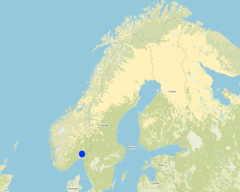
ប្រទេស:
ប្រទេសន័រវែស
តំបន់/រដ្ឋ/ខេត្ត:
Viken county
បញ្ជាក់បន្ថែមពីលក្ខណៈនៃទីតាំង:
The Vansjø - Hobøl catchment
បញ្ជាក់ពីការសាយភាយនៃបច្ចេកទេស:
- ត្រូវបានផ្សព្វផ្សាយត្រឹមតំបន់មួយ
ប្រសិនបើមិនច្បាស់ពីទំហំផ្ទៃដី សូមធ្វើការប៉ាន់ប្រម៉ាណ:
- 1-10 គម2
តើបច្ចេកទេស (មួយ ឬច្រើន) ទាំងនោះស្ថិតនៅក្នុងតំបន់ការពារជាអចិន្ត្រៃយ៍ណាមួយដែរឬទេ?
ទេ
Map
×2.6 កាលបរិច្ឆេទនៃការអនុវត្ត
ប្រសិនបើមិនច្បាស់ឆ្នាំ សូមបញ្ជាក់កាលបរិច្ឆេទដែលប្រហាក់ប្រហែល:
- 10-50 ឆ្នាំ
2.7 ការណែនាំពីបច្ចេកទេស
សូមបញ្ជាក់តើបច្ចេកទេសត្រូវបានណែនាំឱ្យអនុវត្តដោយរបៀបណា:
- ពេលកំពុងពិសោធន៍
- តាមរយៈគម្រោង / អន្តរាគមន៍ពីខាងក្រៅ
- Regional Environmental Programme (RMP)
មតិយោបល់ (ប្រភេទនៃគម្រោង ។ល។):
The Morsa Project (morsa.org)
Buffer zones along streams and lakes are measures eligible for subsidies under the Regional Environmental Programme (RMP).
3. ចំណាត់ថ្នាក់នៃបច្ចេកទេស SLM
3.1 គោលបំណងចម្បង (១ ឬច្រើន) នៃបច្ចេកទេសនេះ
- កាត់បន្ថយ, បង្ការ, ស្តារឡើងវិញនូវការធ្លាក់ចុះគុណភាពដី
- ការពារតំបន់ទីជម្រាល/តំបន់ខ្សែទឹកខាងក្រោមបញ្ចូលជាមួយបច្ចេកទេសផ្សេងទៀត
3.2 ប្រភេទដីប្រើប្រាស់មួយប្រភេទ (ច្រើនប្រភេទ) ដែលបានអនុវត្តបច្ចេកទេស

ដីដាំដំណាំ
- ដំណាំប្រចាំឆ្នាំ
ដំណាំប្រចាំឆ្នាំ - បញ្ជាក់ប្រភេទដំណាំ:
- ធញ្ញជាតិ - ផ្សេងៗ
- small grains
ចំនួនសារដែលដាំដំណាំក្នុងមួយឆ្នាំ:
- 1
សូមបញ្ជាក់:
Longest growing period in days: 135Longest growing period from month to month: May to mid September

ដីព្រៃ/ដីដាំដើមឈើ
ផលិតផល និងសេវាកម្ម:
- អុស
មតិយោបល់:
Major land use problems (compiler’s opinion): Erosion, flooding and landslides, eutrophication of rivers and lakes.
Major land use problems (land users’ perception): Cropland is occupied by the buffer strips, which may lead to decreased production and loss of income.
3.3 បន្ទាប់ពីអនុវត្តបច្ចេកទេស តើដីប្រើប្រាស់មានការប្រែប្រួលដែររឺទេ?
បន្ទាប់ពីអនុវត្តបច្ចេកទេស តើដីប្រើប្រាស់មានការប្រែប្រួលដែររឺទេ?
- បាទ/ច៎ា (សូមបំពេញសំណួរខាងក្រោមពីស្ថានភាពដីប្រើប្រាស់មុនពេលអនុវត្តបច្ចេកទេស)
ដីប្រើប្រាស់ចម្រុះនៅលើដីតែមួយ:
ទេ
ដីដាំដំណាំ
- ដំណាំប្រចាំឆ្នាំ
ដំណាំប្រចាំឆ្នាំ - បញ្ជាក់ប្រភេទដំណាំ:
- ដំណាំចំណីសត្វ - ស្មៅ
មតិយោបល់:
When buffer zones are implemented, part of the cropland is occupied by the grass strips. The grass strips should generally not be ploughed, fertilized or treated by herbicides, but some exceptions may be made. The degree to which it is harvested varies with the grass type, and if it is used for animal fodder.
3.4 ការផ្គត់ផ្គង់ទឹក
ការផ្គត់ផ្គង់ទឹកនៅកន្លែងអនុវត្តបច្ចេកទេស:
- ទឹកភ្លៀង
3.5 ក្រុម SLM ដែលបច្ចេកទេសស្ថិតនៅក្នុង
- ការគ្រប់គ្រងទឹកលើដី (ទឹកធ្លាក់ ទន្លេ បឹង សមុទ្រ)
3.6 វិធានការ SLM ដែលបញ្ចូលនូវបច្ចេកទេស

វិធានការរុក្ខជាតិ
- V2: ស្មៅនិងរុក្ខជាតិៗដែលដុះមានអាយុមិនលើសពី 2ឆ្នាំ
3.7 កំណត់ប្រភេទនៃការធ្លាក់ចុះគុណភាពដីសំខាន់ៗដែលបច្ចេកទេសនេះបានដោះស្រាយ

ការហូរច្រោះដីដោយសារទឹក
- Wt: ការបាត់ដីស្រទាប់លើដោយការហូរច្រោះ
- Wg: ការកកើតឡើងនូវកំទេចកំទីដីស្រទាប់ក្រោម
- Wm: ការបាក់ដី
- Wr: សំណឹកដីច្រាំងទន្លេ

ការបាត់បង់ទឹក
- Hp: ការថយចុះគុណភាពទឹកនៅលើផ្ទៃដី
មតិយោបល់:
Main type of degradation addressed:
Wt: loss of topsoil / surface erosion
Hp: decline of surface water quality
Secondary types of degradation addressed:
Wg: gully erosion/gullying,
Wr: riverbank erosion
Wm: mass movements/landslides,
Main causes of degradation:
soil management - use of fertilizer and heavy machinery (compression of the soil and low infiltration rate)
crop management - annual, perennial, tree/shrub
heavy / extreme rainfall (intensity/amounts) - more flooding and erosion, floods
Secondary causes of degradation:
deforestation / removal of natural vegetation (incl. forest fires) - the runoff has a lower retention time in the forest. Leads to higher velocity and more flooding of downstream cropland areas),
change of seasonal rainfall - heavier rainfall events due to climate change,
land tenure
governance / institutional
3.8 ការពារ កាត់បន្ថយ ឬស្តារឡើងវិញនៃការធ្លាក់ចុះគុណភាពដី
បញ្ជាក់ពីគោលដៅរបស់បច្ចេកទេស ដែលផ្តោតទៅការធ្លាក់ចុះគុណភាពដី:
- ការការពារការធ្លាក់ចុះគុណភាពដី
- ការកាត់បន្ថយការធ្លាក់ចុះគុណភាពដី
មតិយោបល់:
Main goals: mitigation / reduction of land degradation
Secondary goals: prevention of land degradation
4. បច្ចេកទេសជាក់លាក់ សកម្មភាពអនុវត្ត ធាតុចូល និងថ្លៃដើម
4.1 គំនូសបច្ចេកទេសនៃបច្ចេកទេសនេះ
លក្ខណៈពិសេសនៃបច្ចេកទេស (ទាក់ទងនឺងគំនូរបច្ចេកទេស):
A technical drawing of a grass buffer zone - example setup based on the Norwegian recomendation
Technical knowledge required for field staff / advisors: low
Technical knowledge required for land users: low
Main technical functions: control of concentrated runoff: impede / retard
Secondary technical functions: control of raindrop splash, control of dispersed runoff: retain / trap, control of dispersed runoff: impede / retard, control of concentrated runoff: retain / trap, improvement of ground cover, increase of surface roughness, increase of infiltration, increase / maintain water stored in soil, improvement of water quality, buffering / filtering water, sediment retention / trapping, sediment harvesting
Aligned: -along boundary
Vegetative material: T : trees / shrubs
Vegetative measure: Along waterways
Vegetative material: G : grass
Trees/ shrubs species: Naturally
Grass species: Seeded
ឈ្មោះអ្នកនិពន្ធ:
Kamilla Skaalsveen
4.2 ព័ត៌មានទូទៅដែលពាក់ព័ន្ធនឹងការគណនាធាតុចូល និងថ្លៃដើម
កំណត់របៀបនៃការគណនាថ្លៃដើម និងធាតុចូល:
- ក្នុងឯកតាបច្ចេកទេស
បញ្ជាក់ឯកតា:
a buffer zone strip along the stream or lake
បញ្ជាក់ពីទំហំនៃឯកតា (បើពាក់ព័ន្ធ):
dimensions can vary greatly
ផ្សេងៗ/ រូបិយប័ណ្ណជាតិ (បញ្ជាក់):
Kroner (NOK)
បើពាក់ព័ន្ធសូមកំណត់អត្រាប្តូរប្រាក់ពីដុល្លាទៅរូបិយប័ណ្ណតំបន់ (ឧ. 1 ដុល្លារ = 79.9 រៀលនៃរូបិយប័ណ្ណប្រេស៊ីល) ៖ 1 ដុល្លារ =:
8,89
កំណត់ថ្លៃឈ្នួលជាមធ្យមនៃការជួលកម្លាំងពលកម្មក្នុងមួយថ្ងៃ:
c.a. 3000 NOK (it is only the cost of the time assuming 8h work per day, 320-500 NOK/hour; person; machinery, equipment, materials not included)
4.3 សកម្មភាពបង្កើត
| សកម្មភាព | រយៈពេល (រដូវកាល) | |
|---|---|---|
| 1. | Plowing | 1 time/yr |
| 2. | Harrowing | 2-3 times/yr |
| 3. | Sowing grass | 2-3 times/yr |
| 4. | Harvesting grass | 2-3 times/yr |
4.4 ថ្លៃដើម និងធាតុចូលដែលត្រូវការសម្រាប់ការបង្កើតបច្ចេកទេស
| បញ្ជាក់ពីធាតុចូល | ឯកតា | បរិមាណ | ថ្លៃដើមក្នុងមួយឯកតា | ថ្លៃធាតុចូលសរុប | % នៃថ្លៃដើមដែលចំណាយដោយអ្នកប្រើប្រាស់ដី | |
|---|---|---|---|---|---|---|
| កម្លាំងពលកម្ម | Ploughing | zone/farmer/day | 1,0 | 321,0 | 321,0 | 7,0 |
| កម្លាំងពលកម្ម | Harrowing | zone/farmer/day | 1,0 | 321,0 | 321,0 | 7,0 |
| កម្លាំងពលកម្ម | Sowing grass | zone/farmer/day | 1,0 | 321,0 | 321,0 | 7,0 |
| កម្លាំងពលកម្ម | Harvesting grass | zone/farmer/day | 1,0 | 321,0 | 321,0 | 7,0 |
| ថ្លៃដើមសរុបក្នុងការបង្កើតបច្ចេកទេស | 1284,0 | |||||
| ថ្លៃដើមសរុបក្នុងការបង្កើតបច្ចេកទេសគិតជាដុល្លារ | 144,43 | |||||
ប្រសិនបើអ្នកប្រើប្រាស់ដីមិនមានថ្លៃដើម 100% សូមបញ្ជាក់ថានរណាដែលចំណាយថ្លៃដើមដែលនៅសល់:
Grass covered buffer zones are measures eligible for subsidies under the Regional Environmental Programme (RMP)
មតិយោបល់:
The costs of establishment and management of grass covered buffer zone are the same as in the case of regular crop land management. The subsidy is compensation for land withdrawn from the main production (crop land).
Grass covered buffer zones are measures eligible for subsidies under Regional Environmental Programme (RMP) - between 2019 and 2022 the subsidy for grass covered buffer zones was 15 kr/m in Viken county.
4.5 សកម្មភាពថែទាំ
| សកម្មភាព | ពេលវេលា/ ភាពញឹកញាប់ | |
|---|---|---|
| 1. | Ploughing | Every 5th year |
| 2. | Harrowing | Every 5th year |
| 3. | Sowing grass | Every 5th year |
| 4. | Harvesting grass | 1-2 times/yr |
មតិយោបល់:
These areas are often used as grass production areas so some maintenance and harvesting of grass is needed.
4.6 កំណត់ថ្លៃដើមសម្រាប់ការថែទាំ/ សកម្មភាពរបស់បច្ចេកទេស (ក្នុងរយៈពេលមួយឆ្នាំ)
| បញ្ជាក់ពីធាតុចូល | ឯកតា | បរិមាណ | ថ្លៃដើមក្នុងមួយឯកតា | ថ្លៃធាតុចូលសរុប | % នៃថ្លៃដើមដែលចំណាយដោយអ្នកប្រើប្រាស់ដី | |
|---|---|---|---|---|---|---|
| កម្លាំងពលកម្ម | Ploughing | zone/farmer/day | 1,0 | 53,0 | 53,0 | |
| កម្លាំងពលកម្ម | Harrowing | zone/farmer/day | 1,0 | 321,0 | 321,0 | |
| កម្លាំងពលកម្ម | Sowing grass | Day | 1,0 | 321,0 | 321,0 | |
| កម្លាំងពលកម្ម | Harvesting grass | Day | 1,0 | 321,0 | 321,0 | |
| ថ្លៃដើមសរុបសម្រាប់ការថែទាំដំណាំតាមបច្ចេកទេស | 1016,0 | |||||
| ថ្លៃដើមសរុបសម្រាប់ការថែទាំដំណាំតាមបច្ចេកទេសគិតជាដុល្លារ | 114,29 | |||||
ប្រសិនបើអ្នកប្រើប្រាស់ដីមិនមានថ្លៃដើម 100% សូមបញ្ជាក់ថានរណាដែលចំណាយថ្លៃដើមដែលនៅសល់:
Grass covered buffer zones are eligible for subsidies under the Regional Environmental Programme (RMP)
មតិយោបល់:
The costs of establishment and management of grass covered buffer zones are are the same as in case of regular crop land management.
Maintenance of grassed buffer zones is a part of the subsidy system:
-production subsidies - the regulations relating to production subsidies include a number of environmental standards that farmers must meet to receive production support, including two-metre buffer zones along water ways. A farmer who does not comply with the requirements may lose part of their production subsidies.
- RMP - Buffer zones may be eligible for subsidies under the Regional Environmental Programme (RMP) – for 2019-2022 the subsidy level for maintaining grass covered buffer zones was 15 kr/m in the Viken region. The subsidy is compensation for land withdrawn from the main production (crop land).
4.7 កត្តាសំខាន់បំផុតដែលមានឥទ្ធិពលដល់ការចំណាយ
ពណ៌នាពីកត្តាប៉ះពាល់ចម្បងៗទៅលើថ្លៃដើម:
The costs of establishment and management of grass buffer zone are are the same as in case of regular crop land management. The subsidy is compensation for land withdrawn from the main production (crop land).
Establishment and maintenance costs of buffer strip depends mostly on:
- the area (width and continuity) of the buffer strip.
- type of vegetation
- possibility to use the grass as a fodder.
5. លក្ខណៈបរិស្ថានធម្មជាតិ និងមនុស្ស
5.1 អាកាសធាតុ
បរិមាណទឹកភ្លៀងប្រចាំឆ្នាំ
- < 250 មម
- 251-500 មម
- 501-750 មម
- 751-1,000 មម
- 1,001-1,500 មម
- 1,501-2,000 មម
- 2,001-3,000 មម
- 3,001-4,000 មម
- > 4,000 មម
តំបន់កសិអាកាសធាតុ
- មានភ្លៀងមធ្យម
- មានភ្លៀងតិចតួច
Thermal climate class: temperate
Thermal climate class: boreal
5.2 សណ្ឋានដី
ជម្រាលជាមធ្យម:
- រាបស្មើ (0-2%)
- ជម្រាលតិចតួច (3-5%)
- មធ្យម (6-10%)
- ជម្រាលខ្ពស់បន្តិច (11-15%)
- ទីទួល (16-30%)
- ទីទួលចោត (31-60%)
- ទីទួលចោតខ្លាំង (>60%)
ទម្រង់ដី:
- ខ្ពង់រាប
- កំពូលភ្នំ
- ជម្រាលភ្នំ
- ជម្រាលទួល
- ជម្រាលជើងភ្នំ
- បាតជ្រលងភ្នំ
តំបន់តាមរយៈកម្ពស់ :
- 0-100 ម
- 101-500 ម
- 501-1,000 ម
- 1,001-1,500 ម
- 1,501-2,000 ម
- 2,001-2,500 ម
- 2,501-3,000 ម
- 3,001-4,000 ម
- > 4,000 ម
5.3 ដី
ជម្រៅដីជាមធ្យម:
- រាក់ខ្លាំង (0-20 សម)
- រាក់ (21-50 សម)
- មធ្យម (51-80 សម)
- ជ្រៅ (81-120 សម)
- ជ្រៅខ្លាំង (> 120 សម)
វាយនភាពដី (ស្រទាប់លើ):
- មធ្យម (ល្បាយ, ល្បាប់)
- ម៉ត់/ ធ្ងន់ (ឥដ្ឋ)
វាយនភាពដី (> 20 សម ស្រទាប់ក្នុង):
- មធ្យម (ល្បាយ, ល្បាប់)
- ម៉ត់/ ធ្ងន់ (ឥដ្ឋ)
សារធាតុសរីរាង្គនៅស្រទាប់ដីខាងលើ:
- មធ្យម (1-3%)
បើអាចសូមភ្ជាប់ការពណ៌នាពីដីឱ្យបានច្បាស់ ឬព័ត៌មានដែលអាចទទួលបាន ឧ. ប្រភេទដី, pH ដី/ ជាតិអាស៊ីត, សមត្ថភាពផ្លាស់ប្តូរកាចុង, វត្តមាននីត្រូសែន, ភាពប្រៃ ។ល។:
Soil fertility is medium-high
Soil drainage/infiltration is poor
Soil water storage capacity is very low-low
5.4 ទឹកដែលអាចទាញមកប្រើប្រាស់បាន និងគុណភាពទឹក
នីវ៉ូទឹកក្រោមដី:
< 5 ម
ទឹកលើដីដែលអាចទាញយកប្រើប្រាស់បាន:
ល្អ
គុណភាពទឹក (មិនបានធ្វើប្រត្តិកម្ម):
ទឹកសម្រាប់តែការធ្វើកសិកម្ម (ស្រោចស្រព)
គុណភាពទឹក គឺផ្តោតទៅលើ៖:
ទាំងទឹកក្រោមដី និងលើផ្ទៃដី
តើមានបញ្ហាភាពទឹកប្រៃហូរចូលមកដែរឬទេ?
ទេ
តើទឹកជំនន់កំពុងកើតមាននៅតំបន់នេះដែររឺទេ?
បាទ/ចា៎
ភាពទៀងទាត់:
ញឹកញាប់
5.5 ជីវៈចម្រុះ
ភាពសម្បូរបែបនៃប្រភេទ:
- ទាប
ភាពសម្បូរបែបនៃទីជម្រក:
- ទាប
5.6 លក្ខណៈនៃអ្នកប្រើប្រាស់ដីដែលអនុវត្តបច្ចេកទេស
នៅមួយកន្លែង ឬពនេចរ :
- នៅមួយកន្លែង
ទីផ្សារនៃប្រព័ន្ធផលិតកម្ម:
- ពាក់កណ្តាលពាណិជ្ជកម្ម (ផ្គត់ផ្គង់ខ្លួនឯង/ ពាណិជ្ជកម្ម)
- ពាណិជ្ជកម្ម/ ទីផ្សារ
ចំណូលក្រៅកសិកម្ម:
- 10-50% នៃចំណូល
- ច្រើនជាង 50% នៃចំណូល
កម្រិតជីវភាព:
- មធ្យម
- មាន
ឯកជន ឬក្រុម:
- ធ្វើខ្លួនឯង/ គ្រួសារ
កម្រិតប្រើប្រាស់គ្រឿងយន្ត:
- គ្រឿងយន្ត/ ម៉ាស៊ីន
យេនឌ័រ:
- ស្ត្រី
- បុរស
អាយុរបស់អ្នកប្រើប្រាស់ដី:
- យុវវ័យ
- វ័យកណ្តាល
សូមបញ្ជាក់ពីលក្ខណៈពាក់ព័ន្ធផ្សេងទៀតអំពីអ្នកប្រើប្រាស់ដី:
Land users applying the Technology are mainly common / average land users
Population density: < 10 persons/km2
Annual population growth: < 0.5%
10% of the land users are rich and own 10% of the land.
90% of the land users are average wealthy and own 90% of the land.
5.7 ទំហំផ្ទៃដីជាមធ្យមនៃដីប្រើប្រាស់ដោយអ្នកប្រើប្រាស់ដី ក្នុងការអនុវត្តបច្ចេកទេស
- < 0.5 ហិកតា
- 0.5-1 ហិកតា
- 1-2 ហិកតា
- 2-5 ហិកតា
- 5-15 ហិកតា
- 15-50 ហិកតា
- 50-100 ហិកតា
- 100-500 ហិកតា
- 500-1,000 ហិកតា
- 1,000-10,000 ហិកតា
- > 10,000 ហិកតា
តើផ្ទៃដីនេះចាត់ទុកជាទំហំកម្រិតណាដែរ ខ្នាតតូច មធ្យម ឬខ្នាតធំ (ធៀបនឹងបរិបទតំបន់)?
- ខ្នាតមធ្យម
5.8 ភាពជាម្ចាស់ដី កម្មសិទ្ធប្រើប្រាស់ដី និងកម្មសិទ្ធប្រើប្រាស់ទឹក
ភាពជាម្ចាស់ដី:
- ឯកជន មានកម្មសិទ្ធ
កម្មសិទ្ធិប្រើប្រាស់ដី:
- ជាក្រុម (មានដែនកំណត់)
- ឯកជន
កម្មសិទ្ធប្រើប្រាស់ទឹក:
- អាស្រ័យផលសេរី (មិនមានការកំណត់)
5.9 ការប្រើប្រាស់សេវាកម្ម និងហេដ្ឋារចនាសម្ព័ន្ធ
សុខភាព:
- មិនល្អ
- មធ្យម
- ល្អ
ការអប់រំ:
- មិនល្អ
- មធ្យម
- ល្អ
ជំនួយបច្ចេកទេស:
- មិនល្អ
- មធ្យម
- ល្អ
ការងារ (ឧ. ការងារក្រៅកសិដ្ឋាន):
- មិនល្អ
- មធ្យម
- ល្អ
ទីផ្សារ:
- មិនល្អ
- មធ្យម
- ល្អ
ថាមពល:
- មិនល្អ
- មធ្យម
- ល្អ
ផ្លូវ និងការដឹកជញ្ជូន:
- មិនល្អ
- មធ្យម
- ល្អ
ទឹកផឹក និងអនាម័យ:
- មិនល្អ
- មធ្យម
- ល្អ
សេវាកម្មហិរញ្ញវត្ថុ:
- មិនល្អ
- មធ្យម
- ល្អ
6. ផលប៉ះពាល់ និងការសន្និដ្ឋាន
6.1 ផលប៉ះពាល់ក្នុងបរិវេណអនុវត្តបច្ចេកទេសដែលកើតមាន
ផលប៉ះពាល់លើសេដ្ឋកិច្ចសង្គម
ផលិតផល
ផលិតកម្មដំណាំ
ផ្ទៃដីផលិតកម្ម
មតិយោបល់/ ការបញ្ជាក់:
The grass (from buffer strips) is often unfit for fodder
ចំណូល និងថ្លៃដើម
ចំណូលក្នុងកសិដ្ឋាន
មតិយោបល់/ ការបញ្ជាក់:
Despite subsidies, many farmers view grass buffer zones as a financial loss since the grass is often unfit for fodder.
ភាពសម្បូរបែបប្រភពប្រាក់ចំណូល
បន្ទុកការងារ
ផលប៉ះពាល់ទៅលើវប្បធម៌សង្គម
Improved livelihoods and human well-being
មតិយោបល់/ ការបញ្ជាក់:
Because of the drinking water quality
ផលប៉ះពាល់ទៅលើអេកូឡូស៊ី
វដ្តទឹក/លំហូរ
គុណភាពទឹក
មតិយោបល់/ ការបញ្ជាក់:
less sediment and nutrient input to surface water
ដី
គម្របដី
ការបាត់បង់ដី
ដីហាប់
វដ្តនៃសារធាតុចិញ្ចឹម/ការទទួលបាន
ជីវចម្រុះ៖ ដំណាំ, សត្វ
ភាពសម្បូរបែបនៃរុក្ខជាតិ
ប្រភេទសត្វមានប្រយោជន៍
ភាពសម្បូរបែបនៃទីជំរក
6.2 ផលប៉ះពាល់ក្រៅបរិវេណអនុវត្តបច្ចេកទេសដែលកើតមាន
ទឹកក្រោមដី/ ការបំពុលទឹកទន្លេ
Buffering/សមត្ថភាពចម្រោះ
6.3 ភាពប្រឈម និងភាពរួសនៃបច្ចេកទេសទៅនឹងការប្រែប្រួលអាកាសធាតុ និងគ្រោះអាកាសធាតុ/ គ្រោះមហន្តរាយ (ដែលដឹងដោយអ្នកប្រើប្រាស់ដី)
ការប្រែប្រួលអាកាសធាតុ
ការប្រែប្រួលអាកាសធាតុ
| រដូវកាល | កើនឡើង ឬថយចុះ | លក្ខណៈឆ្លើយតបនៃបច្ចេកទេសទៅនឹងការប្រែប្រួលអាកាសធាតុ | |
|---|---|---|---|
| សីតុណ្ហភាពប្រចាំឆ្នាំ | កើនឡើង | ល្អ | |
| បរិមាណទឹកភ្លៀងប្រចាំឆ្នាំ | កើនឡើង | ល្អ |
គ្រោះអាកាសធាតុ (មហន្តរាយ)
គ្រោះមហន្តរាយធម្មជាតិ
| លក្ខណៈឆ្លើយតបនៃបច្ចេកទេសទៅនឹងការប្រែប្រួលអាកាសធាតុ | |
|---|---|
| ព្យុះភ្លៀងតាមតំបន់ | មធ្យម |
| ព្យុះកំបុតត្បូងតាមតំបន់ | ល្អ |
គ្រោះមហន្តរាយអាកាសធាតុ
| លក្ខណៈឆ្លើយតបនៃបច្ចេកទេសទៅនឹងការប្រែប្រួលអាកាសធាតុ | |
|---|---|
| រាំងស្ងួត | ល្អ |
គ្រោះមហន្តរាយទឹក
| លក្ខណៈឆ្លើយតបនៃបច្ចេកទេសទៅនឹងការប្រែប្រួលអាកាសធាតុ | |
|---|---|
| ទឹកជំនន់ទូទៅ (ទន្លេ) | មធ្យម |
ផលវិបាកដែលទាក់ទងនឹងបរិយាកាសផ្សេងៗទៀត
ផលវិបាកដែលទាក់ទងនឹងបរិយាកាសផ្សេងៗទៀត
| លក្ខណៈឆ្លើយតបនៃបច្ចេកទេសទៅនឹងការប្រែប្រួលអាកាសធាតុ | |
|---|---|
| កាត់បន្ថយពេលដាំដុះ | ល្អ |
6.4 ការវិភាគថ្លៃដើម និងអត្ថប្រយោជន៍
តើផលចំណេញ និងថ្លៃដើមត្រូវបានប្រៀបធៀបគ្នាយ៉ាងដូចម្តេច (ទស្សនៈរបស់អ្នកប្រើប្រាស់ដី)?
រយៈពេលខ្លី:
អវិជ្ជមានតិចតួច
រយៈពេលវែង:
ប៉ះពាល់តិចតួចបំផុត
តើផលចំណេញ និងការថែទាំ/ ជួសជុលត្រូវបានប្រៀបធៀបគ្នាយ៉ាងដូចម្តេច (ទស្សនៈរបស់អ្នកប្រើប្រាស់ដី)?
រយៈពេលខ្លី:
អវិជ្ជមានតិចតួច
រយៈពេលវែង:
អវិជ្ជមានតិចតួច
6.5 ការទទួលយកបច្ចេកទេស
- 11-50%
ក្នុងចំណោមគ្រួសារទាំងអស់ដែលបានអនុវត្តបច្ចេកទេស តើមានប៉ុន្មានគ្រួសារដែលចង់ធ្វើដោយខ្លួនឯង ដោយមិនទទួលបានសម្ភារៈលើកទឹកចិត្ត/ប្រាក់ឧបត្ថម្ភ?:
- 0-10%
មតិយោបល់:
There is no trend towards spontaneous adoption of the Technology. Doubts about the retention capacity of buffer zones reduce farmers’ motivation.
Local regulations determine that farmers only receive subsidies per production area along with financial grants if they implement the technology.
6.6 ការបន្សុំា
តើថ្មីៗនេះ បច្ចេកទេសនេះត្រូវបានកែតម្រូវដើម្បីបន្ស៊ាំទៅនឹងស្ថានភាពប្រែប្រួលដែរឬទេ?
ទេ
6.7 ភាពខ្លាំង/ គុណសម្បត្តិ/ ឱកាសនៃបច្ចេកទេស
| ភាពខ្លាំង/ គុណសម្បត្តិ/ ឱកាសនៅកន្លែងរបស់អ្នកប្រើប្រាស់ដី |
|---|
| Probably good for the environment |
| ភាពខ្លាំង/ គុណសម្បត្តិ/ ឱកាស ទស្សនៈរបស់បុគ្គលសំខាន់ៗ |
|---|
|
The grass captures sediments and nutrients from the cropland How can they be sustained / enhanced? May be more efficient with a change in grass type (but this has not been not tested) |
|
Reduced fertilizer usage How can they be sustained / enhanced? Continue in the same way |
|
Co-operation between farmers How can they be sustained / enhanced? Joint utilization of the buffer strips for grass production |
6.8 ភាពខ្សោយ/ គុណវិបត្តិ/ ហានិភ័យនៃបច្ចេកទេស និងវិធីសាស្ត្រដោះស្រាយ
| ភាពខ្សោយ/ គុណវិបត្តិ/ ហានិភ័យ ទស្សនៈរបស់អ្នកប្រើប្រាស់ដី | តើបច្ចេកទេសទាំងនោះបានដោះស្រាយបញ្ហាដូចម្តេច? |
|---|---|
| Loss of productive cropland | Narrower buffer strips |
| Not always good for the farm economy | Review the subsidies scheme |
| Doubts about the effectiveness of the technology (infiltration and stream bank erosion) |
| ភាពខ្សោយ/ គុណវិបត្តិ/ ហានិភ័យ ទស្សនៈរបស់អ្នកចងក្រងឬបុគ្គលសំខាន់ៗ | តើបច្ចេកទេសទាំងនោះបានដោះស្រាយបញ្ហាដូចម្តេច? |
|---|---|
| Low infiltration rates | Less heavy machinery on the buffer strips and a wider zone of natural vegetation along the banks |
7. ឯកសារយោង និងវេបសាយ
7.1 វិធីសាស្ត្រ/ ប្រភពនៃព័ត៌មាន
- តាមការចុះទីវាល ការស្រាវជ្រាវនៅទីវាល
BUFFERKLIMA project (Krzeminska et al 2020)
Projects within Halden, MORSA and PURA water region (Blankenberg and Skarbøvik, 2020)
- ការចងក្រងពីរបាកការណ៍ និងឯកសារផ្សេងៗទៀតដែលមាន
តើពេលណាដែលទិន្នន័យបានចងក្រង (នៅទីវាល)?
10/02/2022
7.2 ឯកសារយោងដែលបានចេញផ្សាយ
ចំណងជើង អ្នកនិពន្ធ ឆ្នាំ ISBN:
Blankenberg, A-G.B., Skarbøvik E., 2020. Phosphorus retention, erosion protection and farmers’ perceptions of riparian buffer zones with grass and natural vegetation: Case studies from South-Eastern Norway.
មានប្រភពមកពីណា? ថ្លៃដើមប៉ុន្មាន?
Ambio
ចំណងជើង អ្នកនិពន្ធ ឆ្នាំ ISBN:
Krzeminska D, Blankenberg A‐G, Bøe F, Nemes A, Skarbøvik E. 2020.Renseeffekt og kanterosjon i kantsoner med forskjellig vegetasjonstype.
មានប្រភពមកពីណា? ថ្លៃដើមប៉ុន្មាន?
NIBIO website
ចំណងជើង អ្នកនិពន្ធ ឆ្នាំ ISBN:
Blankenberg, A-G.B., Skarbøvik E., Kværnø S. 2017. Effekt av buffersoner ‐ på vannmiljø og andre økosystemtjenester.
មានប្រភពមកពីណា? ថ្លៃដើមប៉ុន្មាន?
NIBIO website
7.3 ការភ្ជាប់ទៅកាន់ព័ត៌មានពាក់ព័ន្ធលើប្រព័ន្ធអនឡាញ
ចំណងជើង/ ពណ៌នា:
Blankenberg and Skarbøvik, 2020. Phosphorus retention, erosion protection and farmers’ perceptions of riparian buffer zones with grass and natural vegetation: Case studies from South-Eastern Norway.
វេបសាយ:
https://link.springer.com/content/pdf/10.1007/s13280-020-01361-5.pdf
ចំណងជើង/ ពណ៌នា:
Krzeminska D, Blankenberg A‐G, Bøe F, Nemes A, Skarbøvik E. 2020.Renseeffekt og kanterosjon i kantsoner med forskjellig vegetasjonstype.
វេបសាយ:
https://nibio.brage.unit.no/nibio-xmlui/bitstream/handle/11250/2645890/NIBIO_RAPPORT_2020_6_30.pdf?sequence=2&isAllowed=y
ចំណងជើង/ ពណ៌នា:
Blankenberg, A-G.B., Skarbøvik E., Kværnø S. 2017. Effekt av buffersoner ‐ på vannmiljø og andre økosystemtjenester.
វេបសាយ:
https://nibio.brage.unit.no/nibio-xmlui/bitstream/handle/11250/2448787/NIBIO_RAPPORT_2017_3_14.pdf?sequence=2&isAllowed=y
7.4 មតិយោបល់ទូទៅ
no remarks
ការតភ្ជាប់ និងម៉ូឌុល
ពង្រីកមើលទាំងអស់ បង្រួមទាំងអស់ការតភ្ជាប់
Regional Environmental program [ប្រទេសន័រវែស]
Regulations and financial grants for reduction of pollution and promotion of the cultural landscape.
- អ្នកចងក្រង៖ Kamilla Skaalsveen
ម៉ូឌុល
គ្មានម៉ូឌុល