Usage of Gher boundary for cropping [ប្រទេសបង់ក្លាដែស]
- ការបង្កើត៖
- បច្ចុប្បន្នភាព
- អ្នកចងក្រង៖ Jalal Uddin Md. Shoaib
- អ្នកកែសម្រួល៖ –
- អ្នកត្រួតពិនិត្យ David Streiff
Gherer bunder upar nana prokar shakshabjee uthpadon
technologies_1171 - ប្រទេសបង់ក្លាដែស
ពិនិត្យមើលគ្រប់ផ្នែក
ពង្រីកមើលទាំងអស់ បង្រួមទាំងអស់1. ព័ត៌មានទូទៅ
1.2 ព័ត៌មានលម្អិតពីបុគ្គលសំខាន់ៗ និងស្ថាប័នដែលចូលរួមក្នុងការវាយតម្លៃ និងចងក្រងឯកសារនៃបច្ចេកទេស
អ្នកជំនាញឯកទេស SLM:
Shaha Tapan Kuma
SRDI
ប្រទេសបង់ក្លាដែស
អ្នកជំនាញឯកទេស SLM:
Bhander Bidhan Kumar
SRDI
ប្រទេសបង់ក្លាដែស
ឈ្មោះអង្គភាពមួយ (ច្រើន) ដែលបានចងក្រងឯកសារ/ វាយតម្លៃបច្ចេកទេស (បើទាក់ទង)
Soil Resource Development Institute (SRDI) (Soil Resource Development Institute (SRDI)) - ប្រទេសបង់ក្លាដែស1.3 លក្ខខណ្ឌទាក់ទងទៅនឹងការប្រើប្រាស់ទិន្នន័យដែលបានចងក្រងតាមរយៈ វ៉ូខេត
អ្នកចងក្រង និង(បុគ្គលសំខាន់ៗ)យល់ព្រមទទួលយកនូវលក្ខខណ្ឌនានាទាក់ទងទៅនឹងការប្រើប្រាស់ទិន្នន័យដែលបានចងក្រងតាមរយៈវ៉ូខេត:
បាទ/ចា៎
2. ការពណ៌នាពីបច្ចេកទេស SLM
2.1 ការពណ៌នាដោយសង្ខេបពីបច្ចេកទេស
និយមន័យបច្ចេកទេស:
Gher (shrimp cultivation) boundary usage for multiple cropping.
2.2 ការពណ៌នាលម្អិតពីបច្ចេកទេស
ការពណ៌នា:
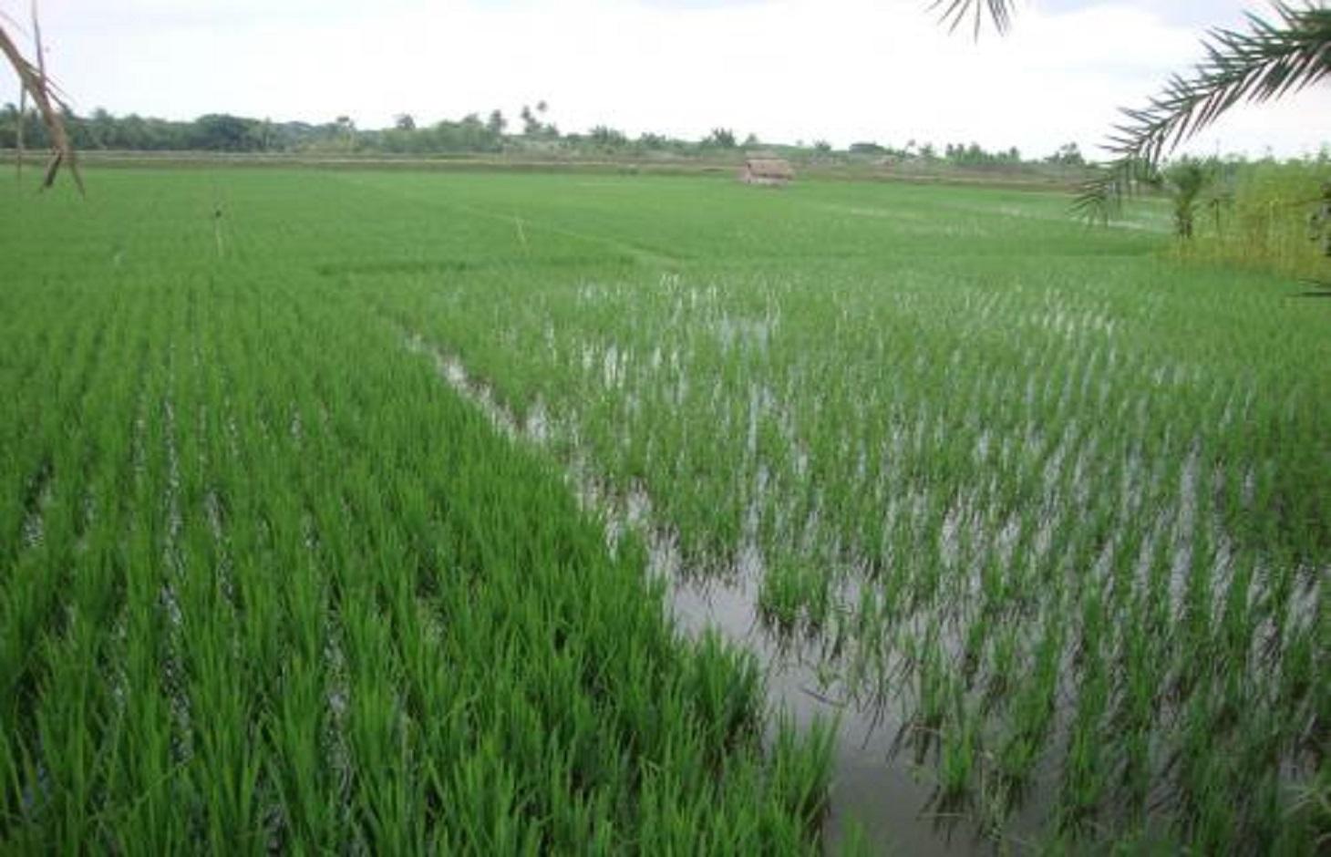
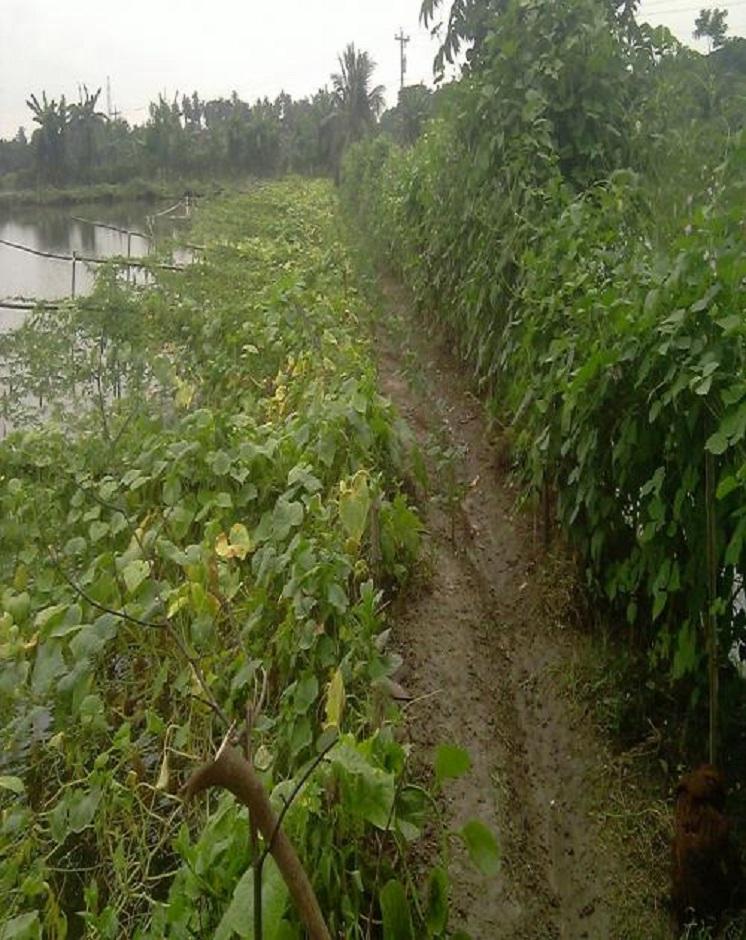
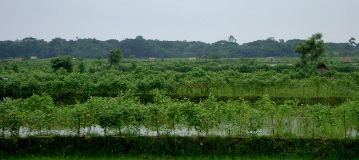
Gher is a local word used for shrimp cultivation plot. The boundaries of these ghers are nowadays raised and maintained to grow vegetables, fruits and also some tree species. In this case the boundary of the plot is raised at least 3 feet with grest width 1 feet plus depending on the height of the boundary (Bund/dyke). Within the gher the land is used for both sweet water prawn (Golda) or saline water prawn (Bagda) with other different types of fishes (locally called Sada Mach) if suitable depending on the salinity of water. Some of the gher lands are used for transplanted Aman with shrimp/fishes.
Farmers dug a ditch along the boundary or in any corner of the field or at the center of the plot to preserve water and fishes during the dry season. In some of the cases the farmers used shallow tube well water to sustain the fishes. In non-to slightly saline areas they used it even for boro (winter rice).
Purpose of the Technology: The purpose of this technology is a boundary which is used for various types of crops, including year round vegetables and land for rice and fishes including shrimps.
Establishment / maintenance activities and inputs: The boundary is constructed above flood level (2-3 feet), the width is approx. 2-3 feet, the ditches are 2-3 feet deep along the boundary or at the corner or at the center.
To grow vegetables farmers used nylon nets for creeping supported by the bamboo or Dhaincha or strings.
Top soils kept on top of the bunds to avoid relatively less fertile soil on the bunds.
Main inputs are seeds of vegetables, nets, bamboo, strings, fingerlings of fish etc.
Natural / human environment: The salinity of the soils from the bunds is washed away by rainwater, which facilitates vegetable production: Rain water desolves salt and moves to the bottom of the bund, and soil becomes non-saline or slightly saline where vegetable could be grown.
2.3 រូបភាពនៃបច្ចេកទេស
វិចិត្រសាលប្រព័ន្ធផ្សព្វផ្សាយ
2.5 ប្រទេស/តំបន់/ទីតាំងកន្លែង ដែលបច្ចេកទេសត្រូវបានអនុវត្ត និងបានគ្រប់ដណ្តប់ដោយការវាយតម្លៃនេះ
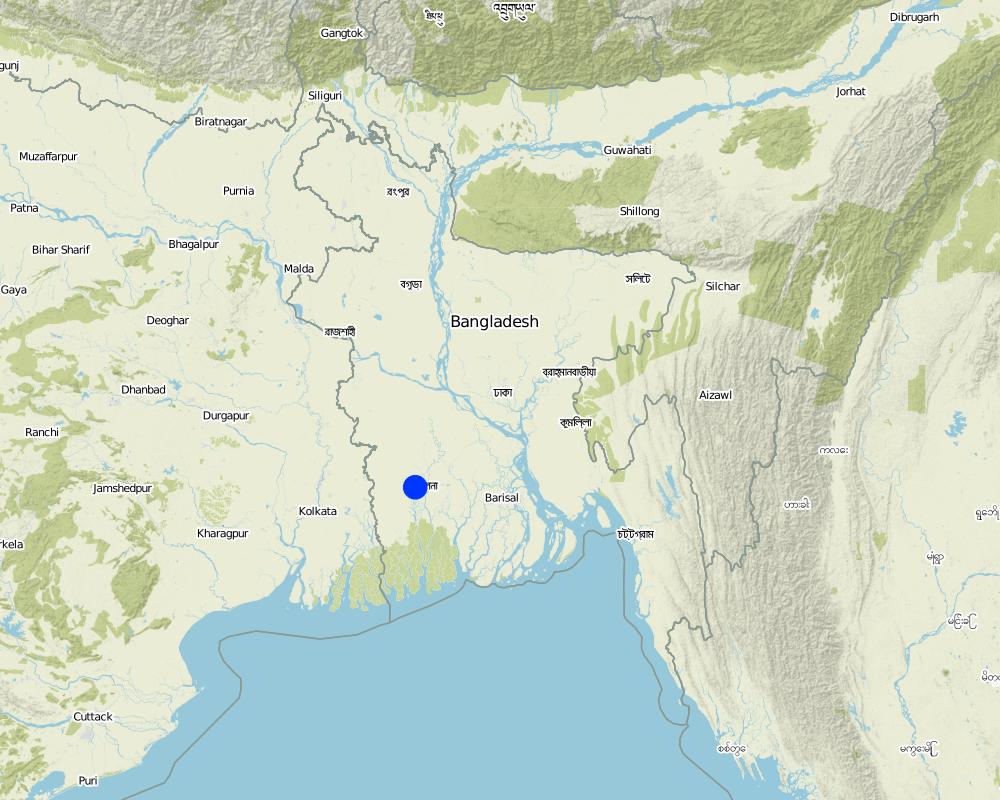
ប្រទេស:
ប្រទេសបង់ក្លាដែស
តំបន់/រដ្ឋ/ខេត្ត:
Bangladesh Southern region
បញ្ជាក់បន្ថែមពីលក្ខណៈនៃទីតាំង:
Khulna
Map
×2.6 កាលបរិច្ឆេទនៃការអនុវត្ត
ប្រសិនបើមិនច្បាស់ឆ្នាំ សូមបញ្ជាក់កាលបរិច្ឆេទដែលប្រហាក់ប្រហែល:
- តិចជាង 10ឆ្នាំមុន (ថ្មី)
2.7 ការណែនាំពីបច្ចេកទេស
សូមបញ្ជាក់តើបច្ចេកទេសត្រូវបានណែនាំឱ្យអនុវត្តដោយរបៀបណា:
- តាមរយៈការបង្កើតថ្មីរបស់អ្នកប្រើប្រាស់ដី
3. ចំណាត់ថ្នាក់នៃបច្ចេកទេស SLM
3.1 គោលបំណងចម្បង (១ ឬច្រើន) នៃបច្ចេកទេសនេះ
- ធ្វើឱ្យប្រសើរឡើងនូវផលិតកម្ម
3.2 ប្រភេទដីប្រើប្រាស់មួយប្រភេទ (ច្រើនប្រភេទ) ដែលបានអនុវត្តបច្ចេកទេស

ដីដាំដំណាំ
- ដំណាំប្រចាំឆ្នាំ

ចម្រុះ (ដំណាំ/ វាលស្មៅ/ ដើមឈើ)គិតទាំងកសិរុក្ខកម្ម
- Cropland and aquaculture
មតិយោបល់:
Major land use problems (compiler’s opinion): Soil and water salinity during dry season; tidal surge; cyclones
Major land use problems (land users’ perception): Water salinity; tidal surge; sidre (name of a cyclone)
Future (final) land use (after implementation of SLM Technology): Mixed: Mo: Other
Type of cropping system and major crops comments: Gher use is very much variable. The main issue of using land is to adapt soil and water salinity. Some ghers are used for only shrimp, some are mixed with other fishes, some are mixed with transplanted Aman. But the boundary/bunds are used for year round vegetables, Banana, fruits (Kul, Guava, Mango) etc.
ប្រសិនបើដីមានការប្រែប្រួលបន្ទាប់ពីការអនុវត្តបច្ចេកទេស សូមបញ្ជាក់ពីការប្រើប្រាស់ដីមុនពេលអនុវត្តន៍បច្ចេកទេស:
Mixed: Mo: Other
3.3 ព័ត៌មានបន្ថែមអំពីអ្នកប្រើប្រាស់ដី
ការផ្គត់ផ្គង់ទឹកនៅកន្លែងអនុវត្តបច្ចេកទេស:
- ទឹកភ្លៀង
មតិយោបល់:
Also mixed rainfed - irrigated
ចំនួនសារដែលដាំដំណាំក្នុងមួយឆ្នាំ:
- 1
សូមបញ្ជាក់:
Longest growing period in days: 160; Longest growing period from month to month: July to Sept
3.4 ក្រុម SLM ដែលបច្ចេកទេសស្ថិតនៅក្នុង
- ការចិញ្ចឹមឃ្មុំ, វារីវប្បកម្ម, ការចិញ្ចឹមបសុបក្សី, ទន្សាយ, ដង្កូវនាង ។ល។
3.5 ការសាយភាយនៃបច្ចេកទេស
បញ្ជាក់ពីការសាយភាយនៃបច្ចេកទេស:
- ត្រូវបានផ្សព្វផ្សាយត្រឹមតំបន់មួយ
ប្រសិនបើបច្ចេកទេសត្រូវបានសាយភាយពាសពេញតំបន់ណាមួយ សូមកំណត់ទំហំផ្ទៃដីអនុវត្តន៍:
- 1-10 គម2
មតិយោបល់:
Gher (Shrimp cultivation) boundary used for multiple crops; vegetables, fruits, tree etc in southern coastal region of Bangladesh.
3.6 វិធានការ SLM ដែលបញ្ចូលនូវបច្ចេកទេស

វិធានការក្សេត្រសាស្ត្រ
- A1: ដំណាំ/គម្របដី

វិធានការរចនាស័ម្ពន្ធ
- S2: ភ្លឺ ច្រាំង

វិធានការគ្រប់គ្រង
- M1: ការផ្លាស់ប្តូរប្រភេទដីប្រើប្រាស់
មតិយោបល់:
Type of agronomic measures: better crop cover, mixed cropping / intercropping
3.7 កំណត់ប្រភេទនៃការធ្លាក់ចុះគុណភាពដីសំខាន់ៗដែលបច្ចេកទេសនេះបានដោះស្រាយ

ការធ្លាក់ចុះសារធាតុគីមីក្នុងដី
- Cs: សារធាតុប្រៃ/អាល់កាឡាំង
មតិយោបល់:
Main causes of degradation: other natural causes (avalanches, volcanic eruptions, mud flows, highly susceptible natural resources, extreme topography, etc.) specify (Salinization: salination of top soil is due to saline ground water coming in shallow depth), Salinization (The area under this issue is in coastal zone. Conflict of land use is prominent. The lands became saline as other stakeholders keep saline water for other uses (salt production, shrimp))
3.8 ការពារ កាត់បន្ថយ ឬស្តារឡើងវិញនៃការធ្លាក់ចុះគុណភាពដី
បញ្ជាក់ពីគោលដៅរបស់បច្ចេកទេស ដែលផ្តោតទៅការធ្លាក់ចុះគុណភាពដី:
- ការជួសជុល/ ស្តារឡើងវិញនៃឱនភាពដីធ្ងន់ធ្ងរ
4. បច្ចេកទេសជាក់លាក់ សកម្មភាពអនុវត្ត ធាតុចូល និងថ្លៃដើម
4.1 គំនូសបច្ចេកទេសនៃបច្ចេកទេសនេះ
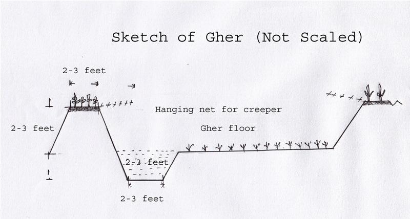
ឈ្មោះអ្នកនិពន្ធ:
Shoaib Jalal
4.2 លក្ខណៈពិសេសនៃបច្ចេកទេស/ ពណ៌នាពីគំនូរបច្ចេកទេស
The gher boundary is raised approximately 2-3 feet with a crest of 2-3 feet. A ditch also dug to store water and fish during dry season.
Location: Dumuria. Khulna
Date: 03-09-13
Technical knowledge required for field staff / advisors: moderate (It is only land manipulation.)
Technical knowledge required for land users: moderate (Previously farmer did not put the top soil on the top of the bunds. That impedes crop production on bunds.)
Main technical functions: increase in nutrient availability (supply, recycling,…), water harvesting / increase water supply, improvement of water quality, buffering / filtering water, promotion of vegetation species and varieties (quality, eg palatable fodder), spatial arrangement and diversification of land use, Decrease of soil salinity, Increase of options for growing more crops
Agronomic measure: Top soil kept on top
Structural measure: Bunds
Height of bunds/banks/others (m): 1
Width of bunds/banks/others (m): 0.5-1
Length of bunds/banks/others (m): 10-50
Construction material (earth): Bunds are raised by piling earth
Change of land use practices / intensity level: Bunds are used for year round cropping
4.3 ព័ត៌មានទូទៅដែលពាក់ព័ន្ធនឹងការគណនាធាតុចូល និងថ្លៃដើម
ផ្សេងៗ/ រូបិយប័ណ្ណជាតិ (បញ្ជាក់):
Taka
កំណត់អត្រាប្តូរប្រាក់ពីដុល្លាទៅរូបិយប័ណ្ណតំបន់ (បើទាក់ទង)៖ 1 ដុល្លារ =:
79,0
4.4 សកម្មភាពបង្កើត
| សកម្មភាព | ប្រភេទវិធានការ | ពេលវេលា | |
|---|---|---|---|
| 1. | Farmers cut the earth from adjacent lands | រចនាសម្ព័ន្ធ | Nov-Dec |
4.5 ថ្លៃដើម និងធាតុចូលដែលត្រូវការសម្រាប់ការបង្កើតបច្ចេកទេស
| បញ្ជាក់ពីធាតុចូល | ឯកតា | បរិមាណ | ថ្លៃដើមក្នុងមួយឯកតា | ថ្លៃធាតុចូលសរុប | % នៃថ្លៃដើមដែលចំណាយដោយអ្នកប្រើប្រាស់ដី | |
|---|---|---|---|---|---|---|
| កម្លាំងពលកម្ម | Farmers cut the earth from adjacent lands | ha | 10,0 | 65,0 | 650,0 | 100,0 |
| កម្លាំងពលកម្ម | Labour | ha | 2,0 | 300,0 | 600,0 | 100,0 |
| កម្លាំងពលកម្ម | Watch and ward | ha | 1,0 | 300,0 | 300,0 | 100,0 |
| សម្ភារៈ | Seeds, nets etc | ha | 1,0 | 50,0 | 50,0 | 100,0 |
| ជី និងសារធាតុពុល | Fertilizer | ha | 1,0 | 5,0 | 5,0 | 100,0 |
| ថ្លៃដើមសរុបក្នុងការបង្កើតបច្ចេកទេស | 1605,0 | |||||
មតិយោបល់:
Duration of establishment phase: 1 month(s)
4.6 សកម្មភាពថែទាំ
| សកម្មភាព | ប្រភេទវិធានការ | ពេលវេលា/ ភាពញឹកញាប់ | |
|---|---|---|---|
| 1. | Transplanting seedlings/seeds | ក្សេត្រសាស្ត្រ | July/Nov |
| 2. | Cultural practices | ក្សេត្រសាស្ត្រ | Aug-Oct/Dec-March |
4.7 កំណត់ថ្លៃដើមសម្រាប់ការថែទាំ/ សកម្មភាពរបស់បច្ចេកទេស (ក្នុងរយៈពេលមួយឆ្នាំ)
| បញ្ជាក់ពីធាតុចូល | ឯកតា | បរិមាណ | ថ្លៃដើមក្នុងមួយឯកតា | ថ្លៃធាតុចូលសរុប | % នៃថ្លៃដើមដែលចំណាយដោយអ្នកប្រើប្រាស់ដី | |
|---|---|---|---|---|---|---|
| កម្លាំងពលកម្ម | Transplanting seedlings/seeds | persons/day/ha | 2,0 | 10,0 | 20,0 | 100,0 |
| ថ្លៃដើមសរុបសម្រាប់ការថែទាំដំណាំតាមបច្ចេកទេស | 20,0 | |||||
មតិយោបល់:
Piling earth to construct gher bunds
4.8 កត្តាសំខាន់បំផុតដែលមានឥទ្ធិពលដល់ការចំណាយ
ពណ៌នាពីកត្តាប៉ះពាល់ចម្បងៗទៅលើថ្លៃដើម:
Availability of labour
5. លក្ខណៈបរិស្ថានធម្មជាតិ និងមនុស្ស
5.1 អាកាសធាតុ
បរិមាណទឹកភ្លៀងប្រចាំឆ្នាំ
- < 250 មម
- 251-500 មម
- 501-750 មម
- 751-1,000 មម
- 1,001-1,500 មម
- 1,501-2,000 មម
- 2,001-3,000 មម
- 3,001-4,000 មម
- > 4,000 មម
លក្ខណៈពិសេស/ មតិយោបល់លើរដូវភ្លៀង:
Most of the rainfall experienced in rainy season
តំបន់កសិអាកាសធាតុ
- សើម
Thermal climate class: tropics
5.2 សណ្ឋានដី
ជម្រាលជាមធ្យម:
- រាបស្មើ (0-2%)
- ជម្រាលតិចតួច (3-5%)
- មធ្យម (6-10%)
- ជម្រាលខ្ពស់បន្តិច (11-15%)
- ទីទួល (16-30%)
- ទីទួលចោត (31-60%)
- ទីទួលចោតខ្លាំង (>60%)
ទម្រង់ដី:
- ខ្ពង់រាប
- កំពូលភ្នំ
- ជម្រាលភ្នំ
- ជម្រាលទួល
- ជម្រាលជើងភ្នំ
- បាតជ្រលងភ្នំ
តំបន់តាមរយៈកម្ពស់ :
- 0-100 ម
- 101-500 ម
- 501-1,000 ម
- 1,001-1,500 ម
- 1,501-2,000 ម
- 2,001-2,500 ម
- 2,501-3,000 ម
- 3,001-4,000 ម
- > 4,000 ម
មតិយោបល់ និងបញ្ចាក់បន្ថែមអំពីសណ្ឋានដី :
Landforms: Coastal plain, narrow ridge with broad flat basin
5.3 ដី
ជម្រៅដីជាមធ្យម:
- រាក់ខ្លាំង (0-20 សម)
- រាក់ (21-50 សម)
- មធ្យម (51-80 សម)
- ជ្រៅ (81-120 សម)
- ជ្រៅខ្លាំង (> 120 សម)
វាយនភាពដី (ស្រទាប់លើ):
- មធ្យម (ល្បាយ, ល្បាប់)
- ម៉ត់/ ធ្ងន់ (ឥដ្ឋ)
សារធាតុសរីរាង្គនៅស្រទាប់ដីខាងលើ:
- ទាប (<1%)
បើអាចសូមភ្ជាប់ការពណ៌នាពីដីឱ្យបានច្បាស់ ឬព័ត៌មានដែលអាចទទួលបាន ឧ. ប្រភេទដី, pH ដី/ ជាតិអាស៊ីត, សមត្ថភាពផ្លាស់ប្តូរកាចុង, វត្តមាននីត្រូសែន, ភាពប្រៃ ។ល។:
Soil fertility is low
Soil drainage / infiltration is poor
Soil water storage capacity is very low - low
5.4 ទឹកដែលអាចទាញមកប្រើប្រាស់បាន និងគុណភាពទឹក
នីវ៉ូទឹកក្រោមដី:
< 5 ម
ទឹកលើដីដែលអាចទាញយកប្រើប្រាស់បាន:
មិនមាន/ គ្មាន
គុណភាពទឹក (មិនបានធ្វើប្រត្តិកម្ម):
ទឹកសម្រាប់តែការធ្វើកសិកម្ម (ស្រោចស្រព)
5.5 ជីវៈចម្រុះ
ភាពសម្បូរបែបនៃប្រភេទ:
- ទាប
5.6 លក្ខណៈនៃអ្នកប្រើប្រាស់ដីដែលអនុវត្តបច្ចេកទេស
ទីផ្សារនៃប្រព័ន្ធផលិតកម្ម:
- ពាក់កណ្តាលពាណិជ្ជកម្ម (ផ្គត់ផ្គង់ខ្លួនឯង/ ពាណិជ្ជកម្ម
- ពាណិជ្ជកម្ម/ ទីផ្សារ
ចំណូលក្រៅកសិកម្ម:
- 10-50% នៃចំណូល
កម្រិតជីវភាព:
- មិនល្អ
ឯកជន ឬក្រុម:
- ធ្វើខ្លួនឯង/ គ្រួសារ
កម្រិតប្រើប្រាស់គ្រឿងយន្ត:
- គ្រឿងយន្ត/ ម៉ាស៊ីន
យេនឌ័រ:
- បុរស
សូមបញ្ជាក់ពីលក្ខណៈពាក់ព័ន្ធផ្សេងទៀតអំពីអ្នកប្រើប្រាស់ដី:
Land users applying the Technology are mainly common / average land users
Difference in the involvement of women and men: Women casually worked during harvesting vegetables
Population density: > 500 persons/km2
Annual population growth: 2% - 3%
70% of the land users are poor.
Level of mechanization: Power triller on hire.
5.7 ទំហំផ្ទៃដីជាមធ្យមនៃដីផ្ទាល់ខ្លួន ឬជួលគេដែលបានអនុវត្តបច្ចេកទេស
- < 0.5 ហិកតា
- 0.5-1 ហិកតា
- 1-2 ហិកតា
- 2-5 ហិកតា
- 5-15 ហិកតា
- 15-50 ហិកតា
- 50-100 ហិកតា
- 100-500 ហិកតា
- 500-1,000 ហិកតា
- 1,000-10,000 ហិកតា
- > 10,000 ហិកតា
តើផ្ទៃដីនេះចាត់ទុកជាទំហំកម្រិតណាដែរ ខ្នាតតូច មធ្យម ឬខ្នាតធំ (ធៀបនឹងបរិបទតំបន់)?
- ខ្នាតតូច
មតិយោបល់:
15-50 ha: Mainly owner of lands of this area
5.8 ភាពជាម្ចាស់ដី កម្មសិទ្ធប្រើប្រាស់ដី និងកម្មសិទ្ធប្រើប្រាស់ទឹក
ភាពជាម្ចាស់ដី:
- ឯកជន មានកម្មសិទ្ធ
កម្មសិទ្ធិប្រើប្រាស់ដី:
- កិច្ចសន្យាជួល
- ឯកជន
កម្មសិទ្ធប្រើប្រាស់ទឹក:
- កិច្ចសន្យាជួល
- ឯកជន
5.9 ការប្រើប្រាស់សេវាកម្ម និងហេដ្ឋារចនាសម្ព័ន្ធ
សុខភាព:
- មិនល្អ
- មធ្យម
- ល្អ
ការអប់រំ:
- មិនល្អ
- មធ្យម
- ល្អ
ជំនួយបច្ចេកទេស:
- មិនល្អ
- មធ្យម
- ល្អ
ការងារ (ឧ. ការងារក្រៅកសិដ្ឋាន):
- មិនល្អ
- មធ្យម
- ល្អ
ទីផ្សារ:
- មិនល្អ
- មធ្យម
- ល្អ
ថាមពល:
- មិនល្អ
- មធ្យម
- ល្អ
ផ្លូវ និងការដឹកជញ្ជូន:
- មិនល្អ
- មធ្យម
- ល្អ
ទឹកផឹក និងអនាម័យ:
- មិនល្អ
- មធ្យម
- ល្អ
សេវាកម្មហិរញ្ញវត្ថុ:
- មិនល្អ
- មធ្យម
- ល្អ
6. ផលប៉ះពាល់ និងការសន្និដ្ឋាន
6.1 ផលប៉ះពាល់ក្នុងបរិវេណអនុវត្តបច្ចេកទេសដែលកើតមាន
ផលប៉ះពាល់លើសេដ្ឋកិច្ចសង្គម
ផលិតផល
ផលិតកម្មដំណាំ
មតិយោបល់/ ការបញ្ជាក់:
Desalinized soil of the bund
ផលប៉ះពាល់ទៅលើវប្បធម៌សង្គម
សន្តិសុខស្បៀង/ ភាពគ្រប់គ្រាន់ខ្លួនឯង
ស្ថានភាពសុខភាព
ឱកាសវប្បធម៍
មតិយោបល់/ ការបញ្ជាក់:
Cash from vegetables
ការកាត់បន្ថយជម្លោះ
មតិយោបល់/ ការបញ្ជាក់:
Conflicts to use water resource
ស្ថានភាពក្រុមដែលមានបញ្ហាក្នុងសង្គម និងសេដ្ឋកិច្ច
livelihood and human well-being
មតិយោបល់/ ការបញ្ជាក់:
Growing and marketing of year round vegetables help the farmer to get cash money throughout the year. That improves their livelihood and access to health care, education etc.
ផលប៉ះពាល់ទៅលើអេកូឡូស៊ី
វដ្តទឹក/លំហូរ
ប្រព័ន្ធបង្ហូរទឹក
មតិយោបល់/ ការបញ្ជាក់:
Ghers are ponded and no water can be drained
ដី
ភាពប្រៃ
មតិយោបល់/ ការបញ្ជាក់:
+ Soil salinity reduced as washed by rainwater -> found in soils of Gher bunds
- Due to ground water abstraction -> found in coastal regions, increasing trend
ជីវចម្រុះ៖ ដំណាំ, សត្វ
ភាពសម្បូរបែបនៃរុក្ខជាតិ
ការកាត់បន្ថយហានិភ័យនៃគ្រោះមហន្តរាយ និងគ្រោះអាកាសធាតុ
ការបំភាយនៃកាបូន និងឧស្ម័នផ្ទះកញ្ចក់
6.3 ភាពប្រឈម និងភាពរួសនៃបច្ចេកទេសទៅនឹងការប្រែប្រួលអាកាសធាតុ និងគ្រោះអាកាសធាតុ/ គ្រោះមហន្តរាយ (ដែលដឹងដោយអ្នកប្រើប្រាស់ដី)
ការប្រែប្រួលអាកាសធាតុ
ការប្រែប្រួលអាកាសធាតុ
| រដូវកាល | ប្រភេទនៃការប្រែប្រួលអាកាសធាតុ/ព្រឹត្តិការណ៍ | លក្ខណៈឆ្លើយតបនៃបច្ចេកទេសទៅនឹងការប្រែប្រួលអាកាសធាតុ | |
|---|---|---|---|
| សីតុណ្ហភាពប្រចាំឆ្នាំ | កើនឡើង | មិនល្អ |
គ្រោះអាកាសធាតុ (មហន្តរាយ)
គ្រោះមហន្តរាយធម្មជាតិ
| លក្ខណៈឆ្លើយតបនៃបច្ចេកទេសទៅនឹងការប្រែប្រួលអាកាសធាតុ | |
|---|---|
| ព្យុះភ្លៀងតាមតំបន់ | មិនល្អ |
| ព្យុះកំបុតត្បូងតាមតំបន់ | មិនល្អ |
មតិយោបល់:
Salinity is washed out from the bund by rainwater. Consequently year round vegetable can be grown on bunds of the gher besides fish in the main land or transplanted rice (depending on the salinity of soil and water and choice of farmers).
6.4 ការវិភាគថ្លៃដើម និងអត្ថប្រយោជន៍
តើផលចំណេញ និងថ្លៃដើមត្រូវបានប្រៀបធៀបគ្នាយ៉ាងដូចម្តេច (ទស្សនៈរបស់អ្នកប្រើប្រាស់ដី)?
រយៈពេលខ្លី:
វិជ្ជមានខ្លាំង
រយៈពេលវែង:
វិជ្ជមានតិចតួច
តើផលចំណេញ និងការថែទាំ/ ជួសជុលត្រូវបានប្រៀបធៀបគ្នាយ៉ាងដូចម្តេច (ទស្សនៈរបស់អ្នកប្រើប្រាស់ដី)?
រយៈពេលខ្លី:
វិជ្ជមានខ្លាំង
រយៈពេលវែង:
វិជ្ជមានតិចតួច
មតិយោបល់:
Long term benefit is yet to be observed
6.5 ការទទួលយកបច្ចេកទេស
មតិយោបល់:
There is a moderate trend towards spontaneous adoption of the Technology
Comments on adoption trend: Leased land users are not capable to adopt the technology.
6.7 ភាពខ្លាំង/ គុណសម្បត្តិ/ ឱកាសនៃបច្ចេកទេស
| ភាពខ្លាំង/ គុណសម្បត្តិ/ ឱកាសនៅកន្លែងរបស់អ្នកប្រើប្រាស់ដី |
|---|
|
Growing more crops will benefit the farmer with more return. As of now marketing of the goods are facilitated by local small entrepreneurs. Most of them have poor linkage with broader markets. How can they be sustained / enhanced? These entrepreneurs could be appropriately linked with bigger one at regional levels (Upazila/ Districts). At the same time road net works are to be alleviated to facilitate access of transport to carry farmers good with all securities. |
| ភាពខ្លាំង/ គុណសម្បត្តិ/ ឱកាស ទស្សនៈរបស់បុគ្គលសំខាន់ៗ |
|---|
|
Land could be used as farmers are managing themselves How can they be sustained / enhanced? To sustain production and produce such as vegetables and fishes deserve uninterrupted marketing linkage essential. |
|
Changes in land management by the farmer to grow multiple crops indeed scale up their economy than before. How can they be sustained / enhanced? To sustain the farming system good variety and quality seeds supply will enhance the scenario. |
6.8 ភាពខ្សោយ/ គុណវិបត្តិ/ ហានិភ័យនៃបច្ចេកទេស និងវិធីសាស្ត្រដោះស្រាយ
| ភាពខ្សោយ/ គុណវិបត្តិ/ ហានិភ័យ ទស្សនៈរបស់អ្នកប្រើប្រាស់ដី | តើបច្ចេកទេសទាំងនោះបានដោះស្រាយបញ្ហាដូចម្តេច? |
|---|---|
| Water management of the areas became critical, specially sweet water | Good water management system is to be introduced through local and regional planning. |
| Conflicts of land uses are prominent. | Social awareness and concept of land zoning seems to be essentials at all levels. |
| ភាពខ្សោយ/ គុណវិបត្តិ/ ហានិភ័យ ទស្សនៈរបស់អ្នកចងក្រងឬបុគ្គលសំខាន់ៗ | តើបច្ចេកទេសទាំងនោះបានដោះស្រាយបញ្ហាដូចម្តេច? |
|---|---|
| Due to construction or rearrangement of field bunds (Dykes) almost all drainages ways blocked. Consequently the whole area became water logged. This situation will definitely aggravate soil quality, environment and ultimate ecosystem | Community approach to manage the landscape will be effective. In this regard local administration and community leaders can play a vital role. |
| Soils of Gher boundaries (Dykes) are subject to erosion when exposed to rain water. | Good cover crops and management are necessary to protect soils from erosion. At same time farmers may be trained on this issue. |
ការតភ្ជាប់ និងម៉ូឌុល
ពង្រីកមើលទាំងអស់ បង្រួមទាំងអស់ការតភ្ជាប់
គ្មានការតភ្ជាប់
ម៉ូឌុល
គ្មានម៉ូឌុល