Cascading Rock Irrigation Channel [ប្រទេសតាហ្ស៊ីគីស្ថាន]
- ការបង្កើត៖
- បច្ចុប្បន្នភាព
- អ្នកចងក្រង៖ Davlatbek Davlatov
- អ្នកកែសម្រួល៖ –
- អ្នកត្រួតពិនិត្យច្រើនទៀត៖ Alexandra Gavilano, David Streiff, Joana Eichenberger
Boloi Dasht (Tajik)
technologies_1454 - ប្រទេសតាហ្ស៊ីគីស្ថាន
ពិនិត្យមើលគ្រប់ផ្នែក
ពង្រីកមើលទាំងអស់ បង្រួមទាំងអស់1. ព័ត៌មានទូទៅ
1.2 ព័ត៌មានលម្អិតពីបុគ្គលសំខាន់ៗ និងស្ថាប័នដែលចូលរួមក្នុងការវាយតម្លៃ និងចងក្រងឯកសារនៃបច្ចេកទេស
អ្នកជំនាញឯកទេស SLM:
ឈ្មោះគម្រោងដែលបានចងក្រងឯកសារ/ វាយតម្លៃលើបច្ចេកទេស (បើទាក់ទង)
Pilot Program for Climate Resilience, Tajikistan (WB / PPCR)ឈ្មោះអង្គភាពមួយ (ច្រើន) ដែលបានចងក្រងឯកសារ/ វាយតម្លៃបច្ចេកទេស (បើទាក់ទង)
CAMP - Central Asian Mountain Partnership (CAMP - Central Asian Mountain Partnership) - ប្រទេសកៀហ្ស៊ីស៊ីស្ថាន1.3 លក្ខខណ្ឌទាក់ទងទៅនឹងការប្រើប្រាស់ទិន្នន័យដែលបានចងក្រងតាមរយៈ វ៉ូខេត
អ្នកចងក្រង និង(បុគ្គលសំខាន់ៗ)យល់ព្រមទទួលយកនូវលក្ខខណ្ឌនានាទាក់ទងទៅនឹងការប្រើប្រាស់ទិន្នន័យដែលបានចងក្រងតាមរយៈវ៉ូខេត:
បាទ/ចា៎
2. ការពណ៌នាពីបច្ចេកទេស SLM
2.1 ការពណ៌នាដោយសង្ខេបពីបច្ចេកទេស
និយមន័យបច្ចេកទេស:
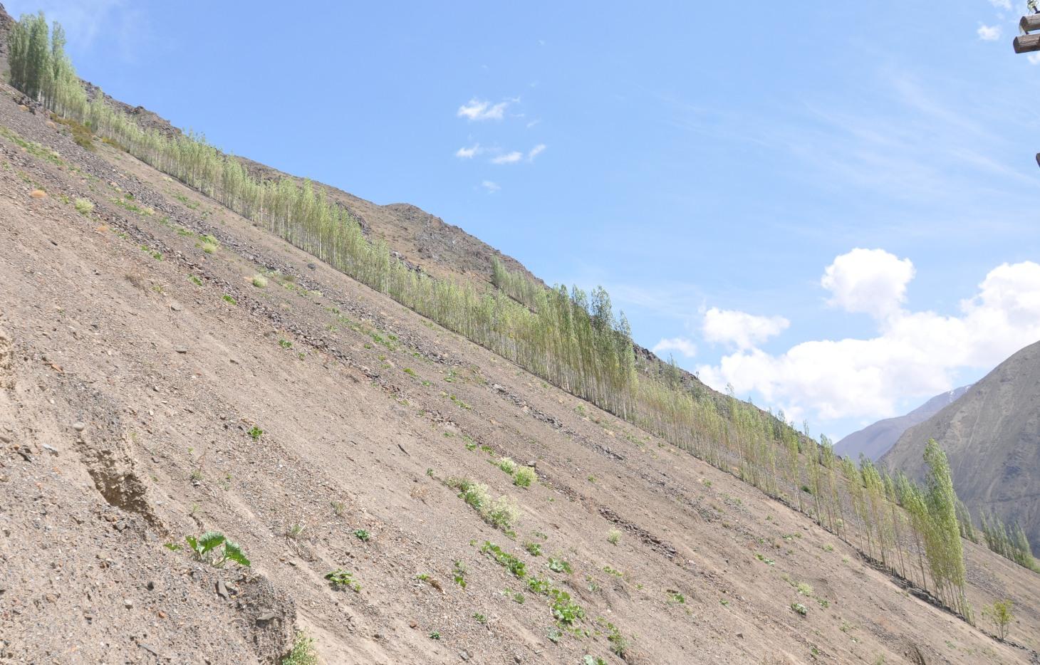
A cascading rock irrigation channel lined with fast growing poplar trees, constructed on rocky slopes to channel water runoff from the high mountains for human use at the valley floor.
2.2 ការពណ៌នាលម្អិតពីបច្ចេកទេស
ការពណ៌នា:
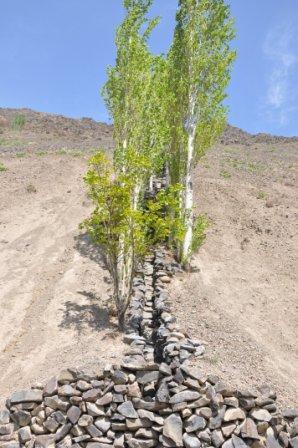
A one metre wide, 300m long, irrigation channel constructed of stones, that is built into the steep slope of a mountain gorge. The channel is 0.5m deep and is lined with poplar trees that help stabilise the structure. The water runs down the channel from the top mountains, with water splashing onto the poplar trees. At the foot of the channel the water is used to irrigated cultivated land and provide drinking water.
Purpose of the Technology: The main purpose of the cascading rock irrigation structure is to capture surface water run-off from the top of the mountain and channel it to where it can be utilised for human use such as drinking water, sanitation, and irrigation. The uneven surface of the rock channel slows the pace of the water thus preventing scouring at the foot of the channel. The channel also provides a suitable environment for the cultivation of poplar trees which in turn can help reduce water and wind erosion on the slopes, thus preventing rock and debris movement down onto the cultivated lands on the valley floor.
Establishment / maintenance activities and inputs: The channel is dug perpendicular to the steep slope and lined with stones gathered from the mountainous slopes. This activity is labour intensive, but can be more efficient with the use of donkeys. The stones are placed upon/on top of each other in the base of the channel, and used to line the sides of the channel to retain the water. The soil along the edge of the channel is cleared of debris and stone until it is suitable for the planting of poplar cuttings. The cutting are supplemented with organic fertiliser. The channel is financed by the land owner, with voluntary support from the community.
Natural / human environment: The cascading rock irrigation channel is located in a remote steep mountainous gorge where there is a shortage of land for cultivation. Water is in short supply, especially during the hot summer months. Subsequently the inhabitants have a high dependency on irrigated water from the top of the mountain range. The majority of the residents have a semi-subsistence living and are highly reliant upon the cultivated land where they grow a range of crops (e.g. wheat, potatoes. etc), fruits (e.g. apricots) and poplar trees for selling and construction purposes.
2.3 រូបភាពនៃបច្ចេកទេស
វិចិត្រសាលប្រព័ន្ធផ្សព្វផ្សាយ
2.5 ប្រទេស/តំបន់/ទីតាំងកន្លែង ដែលបច្ចេកទេសត្រូវបានអនុវត្ត និងបានគ្រប់ដណ្តប់ដោយការវាយតម្លៃនេះ
ប្រទេស:
ប្រទេសតាហ្ស៊ីគីស្ថាន
តំបន់/រដ្ឋ/ខេត្ត:
Sogd region
បញ្ជាក់បន្ថែមពីលក្ខណៈនៃទីតាំង:
Ayni
បញ្ជាក់ពីការសាយភាយនៃបច្ចេកទេស:
- ត្រូវបានផ្សព្វផ្សាយត្រឹមតំបន់មួយ
ប្រសិនបើមិនច្បាស់ពីទំហំផ្ទៃដី សូមធ្វើការប៉ាន់ប្រម៉ាណ:
- < 0.1 គម2 (10 ហិកតា)
មតិយោបល់:
Long and narrow geographical areas were chosen for implementation of the technology. The technology was replicated ten times in this community area.
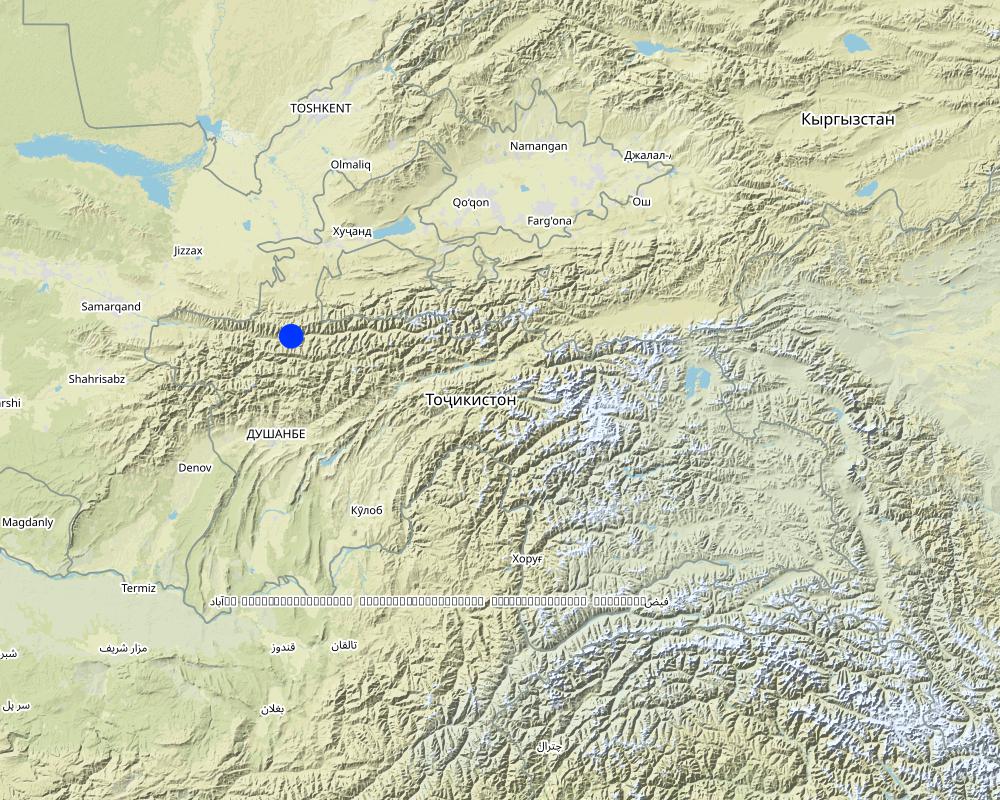
Map
×2.6 កាលបរិច្ឆេទនៃការអនុវត្ត
ប្រសិនបើមិនច្បាស់ឆ្នាំ សូមបញ្ជាក់កាលបរិច្ឆេទដែលប្រហាក់ប្រហែល:
- 10-50 ឆ្នាំ
2.7 ការណែនាំពីបច្ចេកទេស
សូមបញ្ជាក់តើបច្ចេកទេសត្រូវបានណែនាំឱ្យអនុវត្តដោយរបៀបណា:
- តាមរយៈការបង្កើតថ្មីរបស់អ្នកប្រើប្រាស់ដី
មតិយោបល់ (ប្រភេទនៃគម្រោង ។ល។):
The technology was constructed in 1992 and 1997 based upon ideas generated from the local inhabitants.
3. ចំណាត់ថ្នាក់នៃបច្ចេកទេស SLM
3.1 គោលបំណងចម្បង (១ ឬច្រើន) នៃបច្ចេកទេសនេះ
- កាត់បន្ថយ, បង្ការ, ស្តារឡើងវិញនូវការធ្លាក់ចុះគុណភាពដី
- improved access to water
3.2 ប្រភេទដីប្រើប្រាស់មួយប្រភេទ (ច្រើនប្រភេទ) ដែលបានអនុវត្តបច្ចេកទេស

ដីដាំដំណាំ
- ដំណាំប្រចាំឆ្នាំ
- ប្រភេទដើមឈើធំៗ និងដើមឈើតូចៗ
ដំណាំប្រចាំឆ្នាំ - បញ្ជាក់ប្រភេទដំណាំ:
- ធញ្ញជាតិ - ស្រូវសាលី (សិសិររដូវរងារ)
- ឬស/ដំណាំមើម - ដំឡូងបារាំង
ប្រភេទដើមឈើធំៗ និងដើមឈើតូចៗ - បញ្ជាក់ប្រភេទ:
- stone fruits (ផ្លែប៉េស, apricot, ផ្លែឆឺរី, plum ។ល។)
ចំនួនសារដែលដាំដំណាំក្នុងមួយឆ្នាំ:
- 1

ដីព្រៃ/ដីដាំដើមឈើ
- ព្រៃ (ពាក់កណ្តាល) ធម្មជាតិ/ ដីព្រៃ
- ការដាំដើមឈើ ការដាំព្រៃឡើងវិញ
ការដាំដើមឈើ ការដាំដើមឈើឡើងវិញ៖ បញ្ជាក់ពីប្រភេទក្នុងតំបន់ និងប្រភេទលុប:
- ឯកវប្បកម្មដែលប្រើពូជក្នុងតំបន់
ផលិតផល និងសេវាកម្ម:
- ការពារពីគ្រោះធម្មជាតិ
- construction

ផ្សេងៗ
សូមបញ្ជាក់:
Wasteland: The mountain slopes are mainly devoid of vegetation.
មតិយោបល់:
Major land use problems (compiler’s opinion): Water and wind erosion, rockfalls and debris movement.
Major land use problems (land users’ perception): Debris movement due to excessive rains damaging crops and infrastructure.
Selective felling of (semi-) natural forests: Infrequent felling of poplars.
Forest products and services: timber, protection against natural hazards
Other forest products and services: construction
Future (final) land use (after implementation of SLM Technology): Forests / woodlands: Fp: Plantations, afforestations
Constraints of wastelands / deserts / glaciers / swamps
3.3 បន្ទាប់ពីអនុវត្តបច្ចេកទេស តើដីប្រើប្រាស់មានការប្រែប្រួលដែររឺទេ?
ដីដាំដំណាំ
- ដំណាំប្រចាំឆ្នាំ
- ប្រភេទដើមឈើធំៗ និងដើមឈើតូចៗ
ដំណាំប្រចាំឆ្នាំ - បញ្ជាក់ប្រភេទដំណាំ:
- ធញ្ញជាតិ - ស្រូវសាលី (និទាឃរដូវ)
- ឬស/ដំណាំមើម - ដំឡូងបារាំង
ប្រភេទដើមឈើធំៗ និងដើមឈើតូចៗ - បញ្ជាក់ប្រភេទ:
- stone fruits (ផ្លែប៉េស, apricot, ផ្លែឆឺរី, plum ។ល។)
ដីព្រៃ/ដីដាំដើមឈើ
- ការដាំដើមឈើ ការដាំព្រៃឡើងវិញ
3.4 ការផ្គត់ផ្គង់ទឹក
ការផ្គត់ផ្គង់ទឹកនៅកន្លែងអនុវត្តបច្ចេកទេស:
- ទឹកភ្លៀង
មតិយោបល់:
Number of growing seasons per year:
1
Specify:
Longest growing period in days: 180Longest growing period from month to month: March-October
3.5 ក្រុម SLM ដែលបច្ចេកទេសស្ថិតនៅក្នុង
- វិធានការអនុវត្តកាត់ទទឹងទីជម្រាល
- ការគ្រប់គ្រងប្រព័ន្ធស្រោចស្រព (រួមទាំងការផ្គត់ផ្គង់ទឹក ប្រព័ន្ធបង្ហូរ)
- ការបែងចែកទឹក និងប្រព័ន្ធបង្ហូរ
3.6 វិធានការ SLM ដែលបញ្ចូលនូវបច្ចេកទេស

វិធានការក្សេត្រសាស្ត្រ
- A1: ដំណាំ/គម្របដី

វិធានការរុក្ខជាតិ
- V1: ឈើធំៗ និងដើមឈើតូចៗ

វិធានការរចនាស័ម្ពន្ធ
- S3: កម្ពស់ភ្លឺ ប្រឡាយ ផ្លូវទឹក
មតិយោបល់:
Main measures: vegetative measures, structural measures
Type of vegetative measures: aligned: -linear
3.7 កំណត់ប្រភេទនៃការធ្លាក់ចុះគុណភាពដីសំខាន់ៗដែលបច្ចេកទេសនេះបានដោះស្រាយ

ការហូរច្រោះដីដោយសារទឹក
- Wg: ការកកើតឡើងនូវកំទេចកំទីដីស្រទាប់ក្រោម
- Wm: ការបាក់ដី

ការបាត់ដីដោយសារខ្យល់
- Ed: អតិផរណា និង ការទម្លាក់
មតិយោបល់:
Main type of degradation addressed: Wm: mass movements / landslides
Secondary types of degradation addressed: Wg: gully erosion / gullying, Ed: deflation and deposition
Main causes of degradation: deforestation / removal of natural vegetation (incl. forest fires) (Removal of forest vegetation many years before.), Heavy / extreme rainfall (intensity/amounts) (Extreme events lead to debris movement covering fertile lands.)
Secondary causes of degradation: war and conflicts (Lack of natural resources during civil war led to the cutting of many of the trees preventing slope movement.)
3.8 ការពារ កាត់បន្ថយ ឬស្តារឡើងវិញនៃការធ្លាក់ចុះគុណភាពដី
បញ្ជាក់ពីគោលដៅរបស់បច្ចេកទេស ដែលផ្តោតទៅការធ្លាក់ចុះគុណភាពដី:
- ការកាត់បន្ថយការធ្លាក់ចុះគុណភាពដី
4. បច្ចេកទេសជាក់លាក់ សកម្មភាពអនុវត្ត ធាតុចូល និងថ្លៃដើម
4.1 គំនូសបច្ចេកទេសនៃបច្ចេកទេសនេះ
លក្ខណៈពិសេសនៃបច្ចេកទេស (ទាក់ទងនឺងគំនូរបច្ចេកទេស):
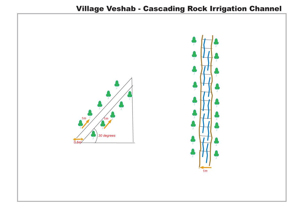
The drawing shows in plan and profile the cascading rock channel. The slope of the mountain is 30 degrees, a one metre wide channel, 0.5 m deep, is dug into the slope. The channel is lined with stones. The soil either side of the channel is cleared of rocks, and poplar branches are planted at 1m intervals lining the channel.
Location: Veshab Boloi Dasht. Ayni Sughd Region Tajikistan
Date: 2011-05-04
Technical knowledge required for land users: moderate (An understanding of how to build the basic structure without it collapsing and able to meet the discharge capacity of the water.)
Main technical functions: control of concentrated runoff: drain / divert, water harvesting / increase water supply, Prevent off site damage to cultivated land at the foot of the slope.
Secondary technical functions: Stabilisation of soil along the channel.
Aligned: -linear
Vegetative material: T : trees / shrubs
Number of plants per (ha): 600
Vertical interval within rows / strips / blocks (m): 1
Width within rows / strips / blocks (m): 1
Trees/ shrubs species: Poplars (safedor) are planted in vertical rows, 1m apart, on both sides of the 1m wide channel.
Slope (which determines the spacing indicated above): 30.00%
Waterway
Depth of ditches/pits/dams (m): 0.5
Width of ditches/pits/dams (m): 1
Length of ditches/pits/dams (m): 300
Construction material (stone): local stones and rocks
Slope (which determines the spacing indicated above): 30%
Vegetation is used for stabilisation of structures.
ឈ្មោះអ្នកនិពន្ធ:
Davlatov Davlatbek, Dushanbe City,Rudaki str.131,fl.19
4.2 ព័ត៌មានទូទៅដែលពាក់ព័ន្ធនឹងការគណនាធាតុចូល និងថ្លៃដើម
កំណត់របៀបនៃការគណនាថ្លៃដើម និងធាតុចូល:
- ក្នុងឯកតាបច្ចេកទេស
ផ្សេងៗ/ រូបិយប័ណ្ណជាតិ (បញ្ជាក់):
Somoni
បើពាក់ព័ន្ធសូមកំណត់អត្រាប្តូរប្រាក់ពីដុល្លាទៅរូបិយប័ណ្ណតំបន់ (ឧ. 1 ដុល្លារ = 79.9 រៀលនៃរូបិយប័ណ្ណប្រេស៊ីល) ៖ 1 ដុល្លារ =:
4,5
កំណត់ថ្លៃឈ្នួលជាមធ្យមនៃការជួលកម្លាំងពលកម្មក្នុងមួយថ្ងៃ:
5.50
4.3 សកម្មភាពបង្កើត
| សកម្មភាព | រយៈពេល (រដូវកាល) | |
|---|---|---|
| 1. | Planting Poplars | Spring, March |
| 2. | Composting | spring |
| 3. | Construction of rock irrigation channel | spring |
4.4 ថ្លៃដើម និងធាតុចូលដែលត្រូវការសម្រាប់ការបង្កើតបច្ចេកទេស
| បញ្ជាក់ពីធាតុចូល | ឯកតា | បរិមាណ | ថ្លៃដើមក្នុងមួយឯកតា | ថ្លៃធាតុចូលសរុប | % នៃថ្លៃដើមដែលចំណាយដោយអ្នកប្រើប្រាស់ដី | |
|---|---|---|---|---|---|---|
| កម្លាំងពលកម្ម | Planting Poplars | Persons/day | 10,0 | 25,0 | 250,0 | 100,0 |
| កម្លាំងពលកម្ម | Construction of rock irrigation channel | Persons/day | 60,0 | 25,0 | 1500,0 | 100,0 |
| សម្ភារៈ | Tools | Pieces | 3,0 | 20,0 | 60,0 | 100,0 |
| សម្ភារៈ | Donkey | Donkey/day | 20,0 | 22,5 | 450,0 | 100,0 |
| សម្ភារៈដាំដុះ | Seedlings | Unit | 1,0 | 266,0 | 266,0 | 100,0 |
| ជី និងសារធាតុពុល | Composte | per tree | 250,0 | 1,0 | 250,0 | 100,0 |
| សម្ភារៈសាងសង់ | Stone | tons | 50,0 | 20,0 | 1000,0 | 100,0 |
| ថ្លៃដើមសរុបក្នុងការបង្កើតបច្ចេកទេស | 3776,0 | |||||
| ថ្លៃដើមសរុបក្នុងការបង្កើតបច្ចេកទេសគិតជាដុល្លារ | 839,11 | |||||
មតិយោបល់:
Duration of establishment phase: 1 month(s)
4.5 សកម្មភាពថែទាំ
| សកម្មភាព | ពេលវេលា/ ភាពញឹកញាប់ | |
|---|---|---|
| 1. | tree tending | every year |
| 2. | Maintenance of channel | Spring |
4.6 កំណត់ថ្លៃដើមសម្រាប់ការថែទាំ/ សកម្មភាពរបស់បច្ចេកទេស (ក្នុងរយៈពេលមួយឆ្នាំ)
| បញ្ជាក់ពីធាតុចូល | ឯកតា | បរិមាណ | ថ្លៃដើមក្នុងមួយឯកតា | ថ្លៃធាតុចូលសរុប | % នៃថ្លៃដើមដែលចំណាយដោយអ្នកប្រើប្រាស់ដី | |
|---|---|---|---|---|---|---|
| កម្លាំងពលកម្ម | Tree tending | Persons/day | 7,0 | 25,0 | 175,0 | 100,0 |
| កម្លាំងពលកម្ម | Maintenance of channel | Persons/day | 10,0 | 25,0 | 250,0 | 100,0 |
| ថ្លៃដើមសរុបសម្រាប់ការថែទាំដំណាំតាមបច្ចេកទេស | 425,0 | |||||
| ថ្លៃដើមសរុបសម្រាប់ការថែទាំដំណាំតាមបច្ចេកទេសគិតជាដុល្លារ | 94,44 | |||||
មតិយោបល់:
The indicative cost of the technology was calculated based on 2010 prices.
4.7 កត្តាសំខាន់បំផុតដែលមានឥទ្ធិពលដល់ការចំណាយ
ពណ៌នាពីកត្តាប៉ះពាល់ចម្បងៗទៅលើថ្លៃដើម:
There was no real cost in construction of the rock irrigation channel. All labour, animal traction and materials were sourced locally for no cost, poplar seedlings are cuttings from local poplars, and organic compost for the trees was collected from local livestock.
5. លក្ខណៈបរិស្ថានធម្មជាតិ និងមនុស្ស
5.1 អាកាសធាតុ
បរិមាណទឹកភ្លៀងប្រចាំឆ្នាំ
- < 250 មម
- 251-500 មម
- 501-750 មម
- 751-1,000 មម
- 1,001-1,500 មម
- 1,501-2,000 មម
- 2,001-3,000 មម
- 3,001-4,000 មម
- > 4,000 មម
លក្ខណៈពិសេស/ មតិយោបល់លើរដូវភ្លៀង:
Heavy Spring and Autumn Rain
តំបន់កសិអាកាសធាតុ
- មានភ្លៀងតិចតួច
Thermal climate class: temperate. 4 months of snowing during the winter period.
5.2 សណ្ឋានដី
ជម្រាលជាមធ្យម:
- រាបស្មើ (0-2%)
- ជម្រាលតិចតួច (3-5%)
- មធ្យម (6-10%)
- ជម្រាលខ្ពស់បន្តិច (11-15%)
- ទីទួល (16-30%)
- ទីទួលចោត (31-60%)
- ទីទួលចោតខ្លាំង (>60%)
ទម្រង់ដី:
- ខ្ពង់រាប
- កំពូលភ្នំ
- ជម្រាលភ្នំ
- ជម្រាលទួល
- ជម្រាលជើងភ្នំ
- បាតជ្រលងភ្នំ
តំបន់តាមរយៈកម្ពស់ :
- 0-100 ម
- 101-500 ម
- 501-1,000 ម
- 1,001-1,500 ម
- 1,501-2,000 ម
- 2,001-2,500 ម
- 2,501-3,000 ម
- 3,001-4,000 ម
- > 4,000 ម
មតិយោបល់ និងបញ្ចាក់បន្ថែមអំពីសណ្ឋានដី :
Altitudinal zone: This area is located at 1500m
5.3 ដី
ជម្រៅដីជាមធ្យម:
- រាក់ខ្លាំង (0-20 សម)
- រាក់ (21-50 សម)
- មធ្យម (51-80 សម)
- ជ្រៅ (81-120 សម)
- ជ្រៅខ្លាំង (> 120 សម)
វាយនភាពដី (ស្រទាប់លើ):
- គ្រើម/ មានពន្លឺ (ខ្សាច់)
សារធាតុសរីរាង្គនៅស្រទាប់ដីខាងលើ:
- ទាប (<1%)
បើអាចសូមភ្ជាប់ការពណ៌នាពីដីឱ្យបានច្បាស់ ឬព័ត៌មានដែលអាចទទួលបាន ឧ. ប្រភេទដី, pH ដី/ ជាតិអាស៊ីត, សមត្ថភាពផ្លាស់ប្តូរកាចុង, វត្តមាននីត្រូសែន, ភាពប្រៃ ។ល។:
Soil texture is rocky, shale.
Soil fertility is very low and nothing is growing on the adjacent slopes.
Soil drainage / infiltration is poor
Soil water storage capacity is very low.
5.4 ទឹកដែលអាចទាញមកប្រើប្រាស់បាន និងគុណភាពទឹក
នីវ៉ូទឹកក្រោមដី:
> 50 ម
ទឹកលើដីដែលអាចទាញយកប្រើប្រាស់បាន:
មិនមាន/ គ្មាន
គុណភាពទឹក (មិនបានធ្វើប្រត្តិកម្ម):
ទឹកពិសារដែលមានគុណភាពល្អ
5.5 ជីវៈចម្រុះ
ភាពសម្បូរបែបនៃប្រភេទ:
- ទាប
មតិយោបល់ និងលក្ខណៈពិសេសផ្សេងទៀតលើជីវចម្រុះ:
No natural propogation/reproduction on the slope and slow growth rate without irrigation.
5.6 លក្ខណៈនៃអ្នកប្រើប្រាស់ដីដែលអនុវត្តបច្ចេកទេស
ទីផ្សារនៃប្រព័ន្ធផលិតកម្ម:
- សម្រាប់ហូបក្នុងគ្រួសារ (ផ្គត់ផ្គង់ខ្លួនឯង)
- ពាក់កណ្តាលពាណិជ្ជកម្ម (ផ្គត់ផ្គង់ខ្លួនឯង/ ពាណិជ្ជកម្ម)
ចំណូលក្រៅកសិកម្ម:
- ច្រើនជាង 50% នៃចំណូល
កម្រិតជីវភាព:
- មធ្យម
ឯកជន ឬក្រុម:
- ជាក្រុម/ សហគមន៍
យេនឌ័រ:
- ស្ត្រី
- បុរស
សូមបញ្ជាក់ពីលក្ខណៈពាក់ព័ន្ធផ្សេងទៀតអំពីអ្នកប្រើប្រាស់ដី:
Land users applying the Technology are mainly common / average land users
Population density: < 10 persons/km2
Annual population growth: 1% - 2%
100% of the land users are average wealthy and own 100% of the land.
Off-farm income specification: Some of the incomes come from driving, teaching etc
Market orientation of production system: Poplars are used for personal construction projects but can be sold for $300 per tree.
5.7 ទំហំផ្ទៃដីជាមធ្យមនៃដីប្រើប្រាស់ដោយអ្នកប្រើប្រាស់ដី ក្នុងការអនុវត្តបច្ចេកទេស
- < 0.5 ហិកតា
- 0.5-1 ហិកតា
- 1-2 ហិកតា
- 2-5 ហិកតា
- 5-15 ហិកតា
- 15-50 ហិកតា
- 50-100 ហិកតា
- 100-500 ហិកតា
- 500-1,000 ហិកតា
- 1,000-10,000 ហិកតា
- > 10,000 ហិកតា
តើផ្ទៃដីនេះចាត់ទុកជាទំហំកម្រិតណាដែរ ខ្នាតតូច មធ្យម ឬខ្នាតធំ (ធៀបនឹងបរិបទតំបន់)?
- ខ្នាតតូច
5.8 ភាពជាម្ចាស់ដី កម្មសិទ្ធប្រើប្រាស់ដី និងកម្មសិទ្ធប្រើប្រាស់ទឹក
ភាពជាម្ចាស់ដី:
- រដ្ឋ
កម្មសិទ្ធិប្រើប្រាស់ដី:
- ជាក្រុម (មានដែនកំណត់)
កម្មសិទ្ធប្រើប្រាស់ទឹក:
- ជាក្រុម (មានដែនកំណត់)
5.9 ការប្រើប្រាស់សេវាកម្ម និងហេដ្ឋារចនាសម្ព័ន្ធ
សុខភាព:
- មិនល្អ
- មធ្យម
- ល្អ
ការអប់រំ:
- មិនល្អ
- មធ្យម
- ល្អ
ជំនួយបច្ចេកទេស:
- មិនល្អ
- មធ្យម
- ល្អ
ការងារ (ឧ. ការងារក្រៅកសិដ្ឋាន):
- មិនល្អ
- មធ្យម
- ល្អ
ទីផ្សារ:
- មិនល្អ
- មធ្យម
- ល្អ
ថាមពល:
- មិនល្អ
- មធ្យម
- ល្អ
ផ្លូវ និងការដឹកជញ្ជូន:
- មិនល្អ
- មធ្យម
- ល្អ
ទឹកផឹក និងអនាម័យ:
- មិនល្អ
- មធ្យម
- ល្អ
សេវាកម្មហិរញ្ញវត្ថុ:
- មិនល្អ
- មធ្យម
- ល្អ
6. ផលប៉ះពាល់ និងការសន្និដ្ឋាន
6.1 ផលប៉ះពាល់ក្នុងបរិវេណអនុវត្តបច្ចេកទេសដែលកើតមាន
ផលប៉ះពាល់លើសេដ្ឋកិច្ចសង្គម
ផលិតផល
ផលិតកម្មឈើ
ផ្ទៃដីផលិតកម្ម
ទឹកដែលអាចទាញមកប្រើប្រាស់បាន និងគុណភាពទឹក
ទឹកបរិភោគដែលអាចទាញយកមកប្រើប្រាស់បាន
ទឹកដែលអាចប្រើប្រាស់បានសម្រាប់ការចិញ្ចឹមសត្វ
ចំណូល និងថ្លៃដើម
ចំណូលក្នុងកសិដ្ឋាន
ផលប៉ះពាល់ទៅលើវប្បធម៌សង្គម
សន្តិសុខស្បៀង/ ភាពគ្រប់គ្រាន់ខ្លួនឯង
ចំណេះដឹង SLM / ការធ្លាក់ចុះគុណភាពដី
Livelihood and human well-being
មតិយោបល់/ ការបញ្ជាក់:
This includes wood for construction, improved water supply for irrigation and improved water quality for drinking and sanitation.
ផលប៉ះពាល់ទៅលើអេកូឡូស៊ី
វដ្តទឹក/លំហូរ
បរិមាណទឹក
គុណភាពទឹក
ការប្រមូលស្តុកទុកទឹក
លំហូរទឹកលើផ្ទៃដី
ដី
ការបាត់បង់ដី
ការកាត់បន្ថយហានិភ័យនៃគ្រោះមហន្តរាយ និងគ្រោះអាកាសធាតុ
ដីបាក់/ លំហូរកំទិចកំទី
ល្បឿនខ្យល់
6.2 ផលប៉ះពាល់ក្រៅបរិវេណអនុវត្តបច្ចេកទេសដែលកើតមាន
ទឹកដែលអាចទាញមកប្រើប្រាស់បាន
ខ្យល់នាំយកនូវធូរលី
ខូចខាតដល់ស្រែអ្នកជិតខាង
ខូចខាតដល់ហេដ្ឋារចនាសម្ព័ន្ធសាធារណៈ/ឯកជន
6.3 ភាពប្រឈម និងភាពរួសនៃបច្ចេកទេសទៅនឹងការប្រែប្រួលអាកាសធាតុ និងគ្រោះអាកាសធាតុ/ គ្រោះមហន្តរាយ (ដែលដឹងដោយអ្នកប្រើប្រាស់ដី)
ការប្រែប្រួលអាកាសធាតុ
ការប្រែប្រួលអាកាសធាតុ
| រដូវកាល | កើនឡើង ឬថយចុះ | លក្ខណៈឆ្លើយតបនៃបច្ចេកទេសទៅនឹងការប្រែប្រួលអាកាសធាតុ | |
|---|---|---|---|
| សីតុណ្ហភាពប្រចាំឆ្នាំ | កើនឡើង | ល្អ |
គ្រោះអាកាសធាតុ (មហន្តរាយ)
គ្រោះមហន្តរាយធម្មជាតិ
| លក្ខណៈឆ្លើយតបនៃបច្ចេកទេសទៅនឹងការប្រែប្រួលអាកាសធាតុ | |
|---|---|
| ព្យុះភ្លៀងតាមតំបន់ | ល្អ |
| ព្យុះកំបុតត្បូងតាមតំបន់ | ល្អ |
គ្រោះមហន្តរាយអាកាសធាតុ
| លក្ខណៈឆ្លើយតបនៃបច្ចេកទេសទៅនឹងការប្រែប្រួលអាកាសធាតុ | |
|---|---|
| រាំងស្ងួត | មិនល្អ |
គ្រោះមហន្តរាយទឹក
| លក្ខណៈឆ្លើយតបនៃបច្ចេកទេសទៅនឹងការប្រែប្រួលអាកាសធាតុ | |
|---|---|
| ទឹកជំនន់ទូទៅ (ទន្លេ) | មិនល្អ |
ផលវិបាកដែលទាក់ទងនឹងបរិយាកាសផ្សេងៗទៀត
ផលវិបាកដែលទាក់ទងនឹងបរិយាកាសផ្សេងៗទៀត
| លក្ខណៈឆ្លើយតបនៃបច្ចេកទេសទៅនឹងការប្រែប្រួលអាកាសធាតុ | |
|---|---|
| mass soil movement | មិនល្អ |
6.4 ការវិភាគថ្លៃដើម និងអត្ថប្រយោជន៍
តើផលចំណេញ និងថ្លៃដើមត្រូវបានប្រៀបធៀបគ្នាយ៉ាងដូចម្តេច (ទស្សនៈរបស់អ្នកប្រើប្រាស់ដី)?
រយៈពេលខ្លី:
វិជ្ជមានខ្លាំង
រយៈពេលវែង:
វិជ្ជមានខ្លាំង
តើផលចំណេញ និងការថែទាំ/ ជួសជុលត្រូវបានប្រៀបធៀបគ្នាយ៉ាងដូចម្តេច (ទស្សនៈរបស់អ្នកប្រើប្រាស់ដី)?
រយៈពេលខ្លី:
វិជ្ជមានខ្លាំង
រយៈពេលវែង:
វិជ្ជមានខ្លាំង
មតិយោបល់:
Low initial expense due to inputs easily available.
6.5 ការទទួលយកបច្ចេកទេស
- 1-10%
បើអាច សូមបញ្ជាក់ពីបរិមាណ (ចំនួនគ្រួសារ និង/ ឬតំបន់គ្របដណ្តប់):
400 households
ក្នុងចំណោមគ្រួសារទាំងអស់ដែលបានអនុវត្តបច្ចេកទេស តើមានប៉ុន្មានគ្រួសារដែលចង់ធ្វើដោយខ្លួនឯង ដោយមិនទទួលបានសម្ភារៈលើកទឹកចិត្ត/ប្រាក់ឧបត្ថម្ភ?:
- 91-100%
មតិយោបល់:
5% of land user families have adopted the Technology without any external material support
400 land user families have adopted the Technology without any external material support
Comments on spontaneous adoption: Minimal replication in small areas of land, but no replication in recent years. (It appears in this area the implementation of the technology may have been optimised).
There is no trend towards spontaneous adoption of the Technology
6.7 ភាពខ្លាំង/ គុណសម្បត្តិ/ ឱកាសនៃបច្ចេកទេស
| ភាពខ្លាំង/ គុណសម្បត្តិ/ ឱកាសនៅកន្លែងរបស់អ្នកប្រើប្រាស់ដី |
|---|
|
Improved livelihoods and the variety and yield of crops. How can they be sustained / enhanced? If the water was not available through the channel then the land would have to be abandoned. |
| The poplar trees provide a good source of secondary income. |
| ភាពខ្លាំង/ គុណសម្បត្តិ/ ឱកាស ទស្សនៈរបស់បុគ្គលសំខាន់ៗ |
|---|
|
It reduces soil and wind erosion from the mountain slopes. How can they be sustained / enhanced? Further planting of trees. |
| It reduces rockfalls and debris movement, thus protecting the land down slope that is used for cultivation. |
|
It provides water for irrigation and hence leads to an increase in crops yields and crop diversification down slope of the channel. These crops include wheat, potatoes, onions and some fruit trees mainly apricot. How can they be sustained / enhanced? Pipes form the channel to other areas. |
|
Increased access to clean running water has improved sanitation and hygiene conditions for the inhabitants. How can they be sustained / enhanced? Further training on hygiene and sanitation. |
| The use of uneven rocks slows down the speed of the water in the channel and prevents water erosion at the base of the slope. |
6.8 ភាពខ្សោយ/ គុណវិបត្តិ/ ហានិភ័យនៃបច្ចេកទេស និងវិធីសាស្ត្រដោះស្រាយ
| ភាពខ្សោយ/ គុណវិបត្តិ/ ហានិភ័យ ទស្សនៈរបស់អ្នកប្រើប្រាស់ដី | តើបច្ចេកទេសទាំងនោះបានដោះស្រាយបញ្ហាដូចម្តេច? |
|---|---|
| The channel can become severely damaged after a harsh winter. | The rock lining could be cemented in but that would increase the cost, and the trees would not be able to use the water that soaks through the channel. |
| ភាពខ្សោយ/ គុណវិបត្តិ/ ហានិភ័យ ទស្សនៈរបស់អ្នកចងក្រងឬបុគ្គលសំខាន់ៗ | តើបច្ចេកទេសទាំងនោះបានដោះស្រាយបញ្ហាដូចម្តេច? |
|---|---|
| The technology is a major construction activity that needs to be strategically positioned. | The location should be carefully considered with help of specialists. |
7. ឯកសារយោង និងវេបសាយ
7.1 វិធីសាស្ត្រ/ ប្រភពនៃព័ត៌មាន
ការតភ្ជាប់ និងម៉ូឌុល
ពង្រីកមើលទាំងអស់ បង្រួមទាំងអស់ការតភ្ជាប់
គ្មានការតភ្ជាប់
ម៉ូឌុល
គ្មានម៉ូឌុល