Check dam ponds [ប្រទេសអេត្យូពី]
- ការបង្កើត៖
- បច្ចុប្បន្នភាព
- អ្នកចងក្រង៖ Eyasu Yazew
- អ្នកកែសម្រួល៖ –
- អ្នកត្រួតពិនិត្យច្រើនទៀត៖ Fabian Ottiger, Alexandra Gavilano
May me'ekori ketri
technologies_1547 - ប្រទេសអេត្យូពី
ពិនិត្យមើលគ្រប់ផ្នែក
ពង្រីកមើលទាំងអស់ បង្រួមទាំងអស់1. ព័ត៌មានទូទៅ
1.2 ព័ត៌មានលម្អិតពីបុគ្គលសំខាន់ៗ និងស្ថាប័នដែលចូលរួមក្នុងការវាយតម្លៃ និងចងក្រងឯកសារនៃបច្ចេកទេស
អ្នកជំនាញឯកទេស SLM:
អ្នកជំនាញឯកទេស SLM:
Kifle Weldearegay
Mekelle University
ប្រទេសអេត្យូពី
ឈ្មោះអង្គភាពមួយ (ច្រើន) ដែលបានចងក្រងឯកសារ/ វាយតម្លៃបច្ចេកទេស (បើទាក់ទង)
Mekelle University (Mekelle University) - ប្រទេសអេត្យូពី1.3 លក្ខខណ្ឌទាក់ទងទៅនឹងការប្រើប្រាស់ទិន្នន័យដែលបានចងក្រងតាមរយៈ វ៉ូខេត
អ្នកចងក្រង និង(បុគ្គលសំខាន់ៗ)យល់ព្រមទទួលយកនូវលក្ខខណ្ឌនានាទាក់ទងទៅនឹងការប្រើប្រាស់ទិន្នន័យដែលបានចងក្រងតាមរយៈវ៉ូខេត:
បាទ/ចា៎
2. ការពណ៌នាពីបច្ចេកទេស SLM
2.1 ការពណ៌នាដោយសង្ខេបពីបច្ចេកទេស
និយមន័យបច្ចេកទេស:
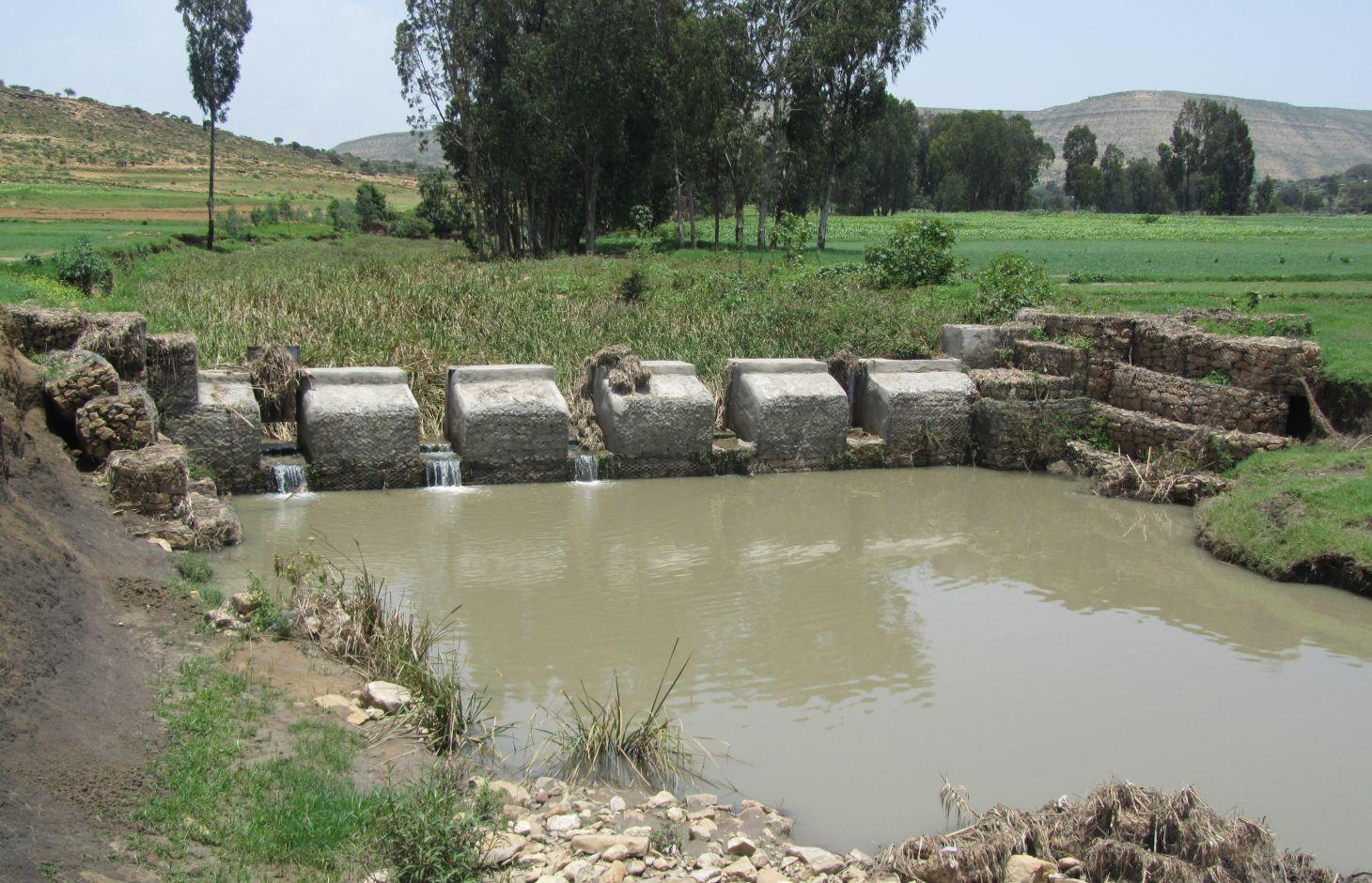
It is a raised wall constructed across a stream/gully using stone, concrete and/or gabion for dual purpose, namely, to pond/store the stream flow behind it for irrigation purpose while at the same time reducing the runoff velocity and enhancing gully rehabilitation.
2.2 ការពណ៌នាលម្អិតពីបច្ចេកទេស
ការពណ៌នា:
A check dam pond is a raised wall constructed across a gully from stone, concrete and/or gabion to store water behind it for irrigation purpose using either gravity or lifting mechanism. The structure generally consists of construction of foundation, apron, retaining wall and the checkdam. The width of the checkdam ranges between 1 - 2 m while the height varies between 1 - 2 m depending up on the gully depth. The length of the checkdam depends on the gully width. The spacing between adjacent checkdams is determined based on two factors, namely, the gradient of the river bed and the availability of potential land that can be irrigated. It is also provided with a number of sluice gates which will be removed during the main rainy season to minimize siltation.
Purpose of the Technology: In addition to storing water for irrigation, check dam ponds decrease slope length, slope angle, runoff velocity and minimize soil erosion.
Establishment / maintenance activities and inputs: Establishment of a check dam pond starts with collection and transportation of stone and sand. The construction is started by setting out the dimensions from the design on the selected site and excavating the foundation for the different parts, namely, key trench, apron and retaining wall. The check dam is then constructed using gabions filled with stones and tightly tied together with wire. Finally the superstructure is plastered using mortar to prevent the passage of water through the body. Gates of about 1 m wide are finally constructed at about 1 m interval and fitted with sluice gates. Maintenance usually involves fixing damaged gates and reinforcing gabions.
Natural / human environment: Check dam pond is implemented in gentle (2 - 5%) and moderate (5 - 8%) slopes and in medium and light soil types of at least 1 m depth. It increases water availability for irrigation and livestock consumption purposes. It also reduces runoff velocity thereby decreasing soil erosion and enhancing gully rehabilitation.
It requires skilled labour and high construction cost. As a result, it is constructed through external support. However, the number of communities seeking for external support and willing to contribute their share is at the rise. The technology minimizes greatly the risk of crop failure and improves the livelihood of the land users.
2.3 រូបភាពនៃបច្ចេកទេស
វិចិត្រសាលប្រព័ន្ធផ្សព្វផ្សាយ

2.5 ប្រទេស/តំបន់/ទីតាំងកន្លែង ដែលបច្ចេកទេសត្រូវបានអនុវត្ត និងបានគ្រប់ដណ្តប់ដោយការវាយតម្លៃនេះ
ប្រទេស:
ប្រទេសអេត្យូពី
តំបន់/រដ្ឋ/ខេត្ត:
Tigray
បញ្ជាក់បន្ថែមពីលក្ខណៈនៃទីតាំង:
Kilite Awlaelo
បញ្ជាក់ពីការសាយភាយនៃបច្ចេកទេស:
- ត្រូវបានផ្សព្វផ្សាយត្រឹមតំបន់មួយ
ប្រសិនបើមិនច្បាស់ពីទំហំផ្ទៃដី សូមធ្វើការប៉ាន់ប្រម៉ាណ:
- 1-10 គម2
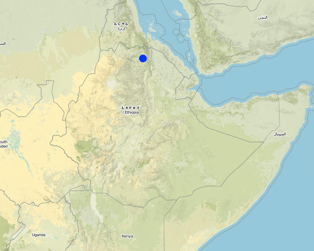
Map
×2.6 កាលបរិច្ឆេទនៃការអនុវត្ត
ប្រសិនបើមិនច្បាស់ឆ្នាំ សូមបញ្ជាក់កាលបរិច្ឆេទដែលប្រហាក់ប្រហែល:
- តិចជាង 10ឆ្នាំមុន (ថ្មី)
2.7 ការណែនាំពីបច្ចេកទេស
សូមបញ្ជាក់តើបច្ចេកទេសត្រូវបានណែនាំឱ្យអនុវត្តដោយរបៀបណា:
- តាមរយៈគម្រោង / អន្តរាគមន៍ពីខាងក្រៅ
3. ចំណាត់ថ្នាក់នៃបច្ចេកទេស SLM
3.2 ប្រភេទដីប្រើប្រាស់មួយប្រភេទ (ច្រើនប្រភេទ) ដែលបានអនុវត្តបច្ចេកទេស

ដីដាំដំណាំ
- ដំណាំប្រចាំឆ្នាំ
ដំណាំប្រចាំឆ្នាំ - បញ្ជាក់ប្រភេទដំណាំ:
- ធញ្ញជាតិ - ស្រូវ
- ធញ្ញជាតិ - ពោត
- បន្លែ - បន្លែយកមើម (ការ៉ុត ខ្ទឹមបារាំង ឆៃថាវម្យ៉ាង ផ្សេងៗ)
- tomatoes, wheat, teff
ចំនួនសារដែលដាំដំណាំក្នុងមួយឆ្នាំ:
- 2
សូមបញ្ជាក់:
Longest growing period in days: 150Longest growing period from month to month: June - NovemberSecond longest growing period in days: 105Second longest growing period from month to month: January - April
មតិយោបល់:
Major land use problems (compiler’s opinion): Deforestation and overgrazing, high erosion risk, gully formation and land loss, decline in productivity.
Major land use problems (land users’ perception): Population pressure, deforestation, flood, soil erosion, reduced productivity.
3.4 ការផ្គត់ផ្គង់ទឹក
ការផ្គត់ផ្គង់ទឹកនៅកន្លែងអនុវត្តបច្ចេកទេស:
- ទឹកភ្លៀង និងប្រព័ន្ធស្រោចស្រព
3.5 ក្រុម SLM ដែលបច្ចេកទេសស្ថិតនៅក្នុង
- ការស្តុកទុកទឹក
- ការគ្រប់គ្រងប្រព័ន្ធស្រោចស្រព (រួមទាំងការផ្គត់ផ្គង់ទឹក ប្រព័ន្ធបង្ហូរ)
- ការគ្រប់គ្រងទឹកលើដី (ទឹកធ្លាក់ ទន្លេ បឹង សមុទ្រ)
3.6 វិធានការ SLM ដែលបញ្ចូលនូវបច្ចេកទេស

វិធានការរចនាស័ម្ពន្ធ
- S6: ជញ្ជាំង, របាំង, របងឈើខ្ពស់ៗ
មតិយោបល់:
Main measures: structural measures
3.7 កំណត់ប្រភេទនៃការធ្លាក់ចុះគុណភាពដីសំខាន់ៗដែលបច្ចេកទេសនេះបានដោះស្រាយ

ការហូរច្រោះដីដោយសារទឹក
- Wt: ការបាត់ដីស្រទាប់លើដោយការហូរច្រោះ
- Wg: ការកកើតឡើងនូវកំទេចកំទីដីស្រទាប់ក្រោម
- Wm: ការបាក់ដី
- Wo: ផលប៉ះពាល់នៃការធ្លាក់ចុះគុណភាពកន្លែងឆ្ងាយ
មតិយោបល់:
Main type of degradation addressed: Wg: gully erosion / gullying
Secondary types of degradation addressed: Wt: loss of topsoil / surface erosion, Wm: mass movements / landslides, Wo: offsite degradation effects
Main causes of degradation: deforestation / removal of natural vegetation (incl. forest fires), Heavy / extreme rainfall (intensity/amounts), other natural causes (avalanches, volcanic eruptions, mud flows, highly susceptible natural resources, extreme topography, etc.) specify (Steep topography that increases amount and velocity of flood), population pressure
Secondary causes of degradation: crop management (annual, perennial, tree/shrub), over-exploitation of vegetation for domestic use, overgrazing, floods, land tenure, poverty / wealth, education, access to knowledge and support services
3.8 ការពារ កាត់បន្ថយ ឬស្តារឡើងវិញនៃការធ្លាក់ចុះគុណភាពដី
បញ្ជាក់ពីគោលដៅរបស់បច្ចេកទេស ដែលផ្តោតទៅការធ្លាក់ចុះគុណភាពដី:
- ការកាត់បន្ថយការធ្លាក់ចុះគុណភាពដី
- ការជួសជុល/ ស្តារឡើងវិញនៃឱនភាពដីធ្ងន់ធ្ងរ
មតិយោបល់:
Main goals: mitigation / reduction of land degradation
Secondary goals: rehabilitation / reclamation of denuded land
4. បច្ចេកទេសជាក់លាក់ សកម្មភាពអនុវត្ត ធាតុចូល និងថ្លៃដើម
4.1 គំនូសបច្ចេកទេសនៃបច្ចេកទេសនេះ
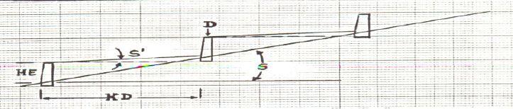
លក្ខណៈពិសេសនៃបច្ចេកទេស (ទាក់ទងនឺងគំនូរបច្ចេកទេស):
Check dam ponds are raised walls constructed across a stream/gully using stone, concrete and/or gabion for dual purpose, namely, to pond/store the stream flow behind it for irrigation purpose while at the same time reducing the runoff velocity and enhancing gully rehabilitation.
Location: Tigray. Kilte Awlaelo
Date: 10/10/2014
Technical knowledge required for field staff / advisors: high
Technical knowledge required for land users: high
Technical knowledge required for Engineer/designer: high
Main technical functions: control of dispersed runoff: impede / retard, reduction of slope length
Secondary technical functions: reduction of slope angle, increase of infiltration, increase of groundwater level / recharge of groundwater, sediment retention / trapping, sediment harvesting
Wall/ barrier
Vertical interval between structures (m): n/a
Spacing between structures (m): n/a
Height of bunds/banks/others (m): 1 - 2
Width of bunds/banks/others (m): 1 - 2
Construction material (stone): Stones are usually shaped in order to piece together very well.
Construction material (concrete): The chekdam is usually plastered by concrete on the upstream side to prevent the passage of water th
Construction material (other): Gabion, Sheet metal and Angle iron.
Slope (which determines the spacing indicated above): 2 - 8%
Lateral gradient along the structure: 0%
ឈ្មោះអ្នកនិពន្ធ:
Eyasu Yazew, P.O.Box 231, Mekelle University, Mekelle, Ethiopia
4.2 ព័ត៌មានទូទៅដែលពាក់ព័ន្ធនឹងការគណនាធាតុចូល និងថ្លៃដើម
ផ្សេងៗ/ រូបិយប័ណ្ណជាតិ (បញ្ជាក់):
Birr
បើពាក់ព័ន្ធសូមកំណត់អត្រាប្តូរប្រាក់ពីដុល្លាទៅរូបិយប័ណ្ណតំបន់ (ឧ. 1 ដុល្លារ = 79.9 រៀលនៃរូបិយប័ណ្ណប្រេស៊ីល) ៖ 1 ដុល្លារ =:
18,0
កំណត់ថ្លៃឈ្នួលជាមធ្យមនៃការជួលកម្លាំងពលកម្មក្នុងមួយថ្ងៃ:
2.50
4.3 សកម្មភាពបង្កើត
| សកម្មភាព | រយៈពេល (រដូវកាល) | |
|---|---|---|
| 1. | Site clearance and excavation of foundation | Dry season |
| 2. | Stone collection and transportation | Dry season |
| 3. | Sand collection and transportation | Dry season |
| 4. | Gabion masonry work | Dry season |
| 5. | Plastering | Dry season |
4.4 ថ្លៃដើម និងធាតុចូលដែលត្រូវការសម្រាប់ការបង្កើតបច្ចេកទេស
| បញ្ជាក់ពីធាតុចូល | ឯកតា | បរិមាណ | ថ្លៃដើមក្នុងមួយឯកតា | ថ្លៃធាតុចូលសរុប | % នៃថ្លៃដើមដែលចំណាយដោយអ្នកប្រើប្រាស់ដី | |
|---|---|---|---|---|---|---|
| កម្លាំងពលកម្ម | Labour | ha | 1,0 | 4678,0 | 4678,0 | 25,0 |
| សម្ភារៈសាងសង់ | Cement | ha | 1,0 | 953,0 | 953,0 | |
| សម្ភារៈសាងសង់ | Gabion | ha | 1,0 | 6268,0 | 6268,0 | |
| សម្ភារៈសាងសង់ | Sheet metal | ha | 1,0 | 44,0 | 44,0 | |
| សម្ភារៈសាងសង់ | Angle iron | ha | 1,0 | 56,0 | 56,0 | |
| ថ្លៃដើមសរុបក្នុងការបង្កើតបច្ចេកទេស | 11999,0 | |||||
| ថ្លៃដើមសរុបក្នុងការបង្កើតបច្ចេកទេសគិតជាដុល្លារ | 666,61 | |||||
មតិយោបល់:
Duration of establishment phase: 6 month(s)
4.5 សកម្មភាពថែទាំ
| សកម្មភាព | ពេលវេលា/ ភាពញឹកញាប់ | |
|---|---|---|
| 1. | Fixing damaged gates and reinforcing gabions | Dry season |
4.6 កំណត់ថ្លៃដើមសម្រាប់ការថែទាំ/ សកម្មភាពរបស់បច្ចេកទេស (ក្នុងរយៈពេលមួយឆ្នាំ)
មតិយោបល់:
Machinery/ tools: Digging hoe, shovel, hammer, crow bar
Since the check dam ponds generally vary in depth, width and most importantly in length depending up on the gully profile, calculation of cost per meter length will not be a reliable presentation. As a result, one typical check dam pond was selected and the total volume of the structure and the corresponding total cost of construction calculated. Then, the cost per cubic meter of the check dam was determined by dividing the total construction cost to the total volume of the structure.
The calculation includes the cost for the purchase of industrial materials (cement, gabion, sheet metal and angle iron) and cost of labour used for the construction including site clearance and excavation of foundation, stone and sand collection and transportation, gabion masonry work and plastering.
The price of the industrial materials and the labour wage used in the cost calculation apply to 2012. The daily labour wage for plastering is 180 Birr while it is 50 Birr for all other works.
4.7 កត្តាសំខាន់បំផុតដែលមានឥទ្ធិពលដល់ការចំណាយ
ពណ៌នាពីកត្តាប៉ះពាល់ចម្បងៗទៅលើថ្លៃដើម:
Labour, availability of construction material, depth and width of gully.
5. លក្ខណៈបរិស្ថានធម្មជាតិ និងមនុស្ស
5.1 អាកាសធាតុ
បរិមាណទឹកភ្លៀងប្រចាំឆ្នាំ
- < 250 មម
- 251-500 មម
- 501-750 មម
- 751-1,000 មម
- 1,001-1,500 មម
- 1,501-2,000 មម
- 2,001-3,000 មម
- 3,001-4,000 មម
- > 4,000 មម
លក្ខណៈពិសេស/ មតិយោបល់លើរដូវភ្លៀង:
Average rainfall of 450-550 mm, Main rainy season from Mid-June to August.
តំបន់កសិអាកាសធាតុ
- មានភ្លៀងតិចតួច
Thermal climate class: subtropics
5.2 សណ្ឋានដី
ជម្រាលជាមធ្យម:
- រាបស្មើ (0-2%)
- ជម្រាលតិចតួច (3-5%)
- មធ្យម (6-10%)
- ជម្រាលខ្ពស់បន្តិច (11-15%)
- ទីទួល (16-30%)
- ទីទួលចោត (31-60%)
- ទីទួលចោតខ្លាំង (>60%)
ទម្រង់ដី:
- ខ្ពង់រាប
- កំពូលភ្នំ
- ជម្រាលភ្នំ
- ជម្រាលទួល
- ជម្រាលជើងភ្នំ
- បាតជ្រលងភ្នំ
តំបន់តាមរយៈកម្ពស់ :
- 0-100 ម
- 101-500 ម
- 501-1,000 ម
- 1,001-1,500 ម
- 1,501-2,000 ម
- 2,001-2,500 ម
- 2,501-3,000 ម
- 3,001-4,000 ម
- > 4,000 ម
5.3 ដី
ជម្រៅដីជាមធ្យម:
- រាក់ខ្លាំង (0-20 សម)
- រាក់ (21-50 សម)
- មធ្យម (51-80 សម)
- ជ្រៅ (81-120 សម)
- ជ្រៅខ្លាំង (> 120 សម)
វាយនភាពដី (ស្រទាប់លើ):
- គ្រើម/ មានពន្លឺ (ខ្សាច់)
- មធ្យម (ល្បាយ, ល្បាប់)
សារធាតុសរីរាង្គនៅស្រទាប់ដីខាងលើ:
- ទាប (<1%)
បើអាចសូមភ្ជាប់ការពណ៌នាពីដីឱ្យបានច្បាស់ ឬព័ត៌មានដែលអាចទទួលបាន ឧ. ប្រភេទដី, pH ដី/ ជាតិអាស៊ីត, សមត្ថភាពផ្លាស់ប្តូរកាចុង, វត្តមាននីត្រូសែន, ភាពប្រៃ ។ល។:
Soil fertility is low (medium soils, ranked 1) and very low (light soils, ranked 2)
Soil drainage/infiltration is medium (ranked 1) and good (ranked 2)
Soil water storage capacity is medium (ranked 1) and low (ranked 2)
5.4 ទឹកដែលអាចទាញមកប្រើប្រាស់បាន និងគុណភាពទឹក
នីវ៉ូទឹកក្រោមដី:
5-50 ម
ទឹកលើដីដែលអាចទាញយកប្រើប្រាស់បាន:
ល្អ
គុណភាពទឹក (មិនបានធ្វើប្រត្តិកម្ម):
ទឹកសម្រាប់តែការធ្វើកសិកម្ម (ស្រោចស្រព)
មតិយោបល់ និងលក្ខណៈពិសេសផ្សេងៗទៀតលើគុណភាព និងបរិមាណទឹក :
Availability of surface water is good (September - January). Also medium (February-June)
5.5 ជីវៈចម្រុះ
ភាពសម្បូរបែបនៃប្រភេទ:
- ទាប
5.6 លក្ខណៈនៃអ្នកប្រើប្រាស់ដីដែលអនុវត្តបច្ចេកទេស
ទីផ្សារនៃប្រព័ន្ធផលិតកម្ម:
- សម្រាប់ហូបក្នុងគ្រួសារ (ផ្គត់ផ្គង់ខ្លួនឯង)
ចំណូលក្រៅកសិកម្ម:
- តិចជាង 10% នៃចំណូល
កម្រិតជីវភាព:
- មិនល្អ
- មធ្យម
ឯកជន ឬក្រុម:
- ជាក្រុម/ សហគមន៍
កម្រិតប្រើប្រាស់គ្រឿងយន្ត:
- ប្រើកម្លាំងពលកម្ម
- ប្រើកម្លាំងសត្វ
យេនឌ័រ:
- ស្ត្រី
- បុរស
សូមបញ្ជាក់ពីលក្ខណៈពាក់ព័ន្ធផ្សេងទៀតអំពីអ្នកប្រើប្រាស់ដី:
Land users applying the Technology are mainly common / average land users
Population density: 100-200 persons/km2
Annual population growth: 2% - 3%
10% of the land users are rich and own 10% of the land.
60% of the land users are average wealthy and own 55% of the land (35 Birr/day/person).
30% of the land users are poor and own 35% of the land.
5.7 ទំហំផ្ទៃដីជាមធ្យមនៃដីប្រើប្រាស់ដោយអ្នកប្រើប្រាស់ដី ក្នុងការអនុវត្តបច្ចេកទេស
- < 0.5 ហិកតា
- 0.5-1 ហិកតា
- 1-2 ហិកតា
- 2-5 ហិកតា
- 5-15 ហិកតា
- 15-50 ហិកតា
- 50-100 ហិកតា
- 100-500 ហិកតា
- 500-1,000 ហិកតា
- 1,000-10,000 ហិកតា
- > 10,000 ហិកតា
តើផ្ទៃដីនេះចាត់ទុកជាទំហំកម្រិតណាដែរ ខ្នាតតូច មធ្យម ឬខ្នាតធំ (ធៀបនឹងបរិបទតំបន់)?
- ខ្នាតតូច
មតិយោបល់:
Average land holding is 0.6 ha per household.
5.8 ភាពជាម្ចាស់ដី កម្មសិទ្ធប្រើប្រាស់ដី និងកម្មសិទ្ធប្រើប្រាស់ទឹក
ភាពជាម្ចាស់ដី:
- រដ្ឋ
កម្មសិទ្ធិប្រើប្រាស់ដី:
- ជាក្រុម (មានដែនកំណត់)
- ឯកជន
កម្មសិទ្ធប្រើប្រាស់ទឹក:
- ជាក្រុម (មានដែនកំណត់)
5.9 ការប្រើប្រាស់សេវាកម្ម និងហេដ្ឋារចនាសម្ព័ន្ធ
សុខភាព:
- មិនល្អ
- មធ្យម
- ល្អ
ការអប់រំ:
- មិនល្អ
- មធ្យម
- ល្អ
ជំនួយបច្ចេកទេស:
- មិនល្អ
- មធ្យម
- ល្អ
ការងារ (ឧ. ការងារក្រៅកសិដ្ឋាន):
- មិនល្អ
- មធ្យម
- ល្អ
ទីផ្សារ:
- មិនល្អ
- មធ្យម
- ល្អ
ថាមពល:
- មិនល្អ
- មធ្យម
- ល្អ
ផ្លូវ និងការដឹកជញ្ជូន:
- មិនល្អ
- មធ្យម
- ល្អ
ទឹកផឹក និងអនាម័យ:
- មិនល្អ
- មធ្យម
- ល្អ
សេវាកម្មហិរញ្ញវត្ថុ:
- មិនល្អ
- មធ្យម
- ល្អ
Mobile communication:
- មិនល្អ
- មធ្យម
- ល្អ
6. ផលប៉ះពាល់ និងការសន្និដ្ឋាន
6.1 ផលប៉ះពាល់ក្នុងបរិវេណអនុវត្តបច្ចេកទេសដែលកើតមាន
ផលប៉ះពាល់លើសេដ្ឋកិច្ចសង្គម
ផលិតផល
ផលិតកម្មដំណាំ
ហានិភ័យនៃភាពបរាជ័យរបស់ផលិតកម្ម
ទឹកដែលអាចទាញមកប្រើប្រាស់បាន និងគុណភាពទឹក
ទឹកដែលអាចប្រើប្រាស់បានសម្រាប់ការចិញ្ចឹមសត្វ
គុណភាពទឹកសម្រាប់ការចិញ្ចឹមសត្វ
ទឹកប្រើប្រាស់សម្រាប់ស្រោចស្រព
គុណភាពទឹកស្រោចស្រព
ចំណូល និងថ្លៃដើម
ការចំណាយលើធាតុចូលកសិកម្ម
ចំណូលក្នុងកសិដ្ឋាន
បន្ទុកការងារ
មតិយោបល់/ ការបញ្ជាក់:
Also: Requires skilled labour
ផលប៉ះពាល់ទៅលើវប្បធម៌សង្គម
សន្តិសុខស្បៀង/ ភាពគ្រប់គ្រាន់ខ្លួនឯង
ស្ថានភាពសុខភាព
មតិយោបល់/ ការបញ្ជាក់:
Increased investment in health care as a result of increased income.
ស្ថាប័នសហគមន៍
ចំណេះដឹង SLM / ការធ្លាក់ចុះគុណភាពដី
ការកាត់បន្ថយជម្លោះ
ស្ថានភាពក្រុមដែលមានបញ្ហាក្នុងសង្គម និងសេដ្ឋកិច្ច
Improved livelihoods and human well-being
ផលប៉ះពាល់ទៅលើអេកូឡូស៊ី
វដ្តទឹក/លំហូរ
បរិមាណទឹក
ការប្រមូលស្តុកទុកទឹក
នីវ៉ូទឹកក្រោមដី/ ដង្ហើមទឹក
រំហួត
ដី
ការបាត់បង់ដី
ជីវចម្រុះ៖ ដំណាំ, សត្វ
ភាពសម្បូរបែបនៃរុក្ខជាតិ
6.2 ផលប៉ះពាល់ក្រៅបរិវេណអនុវត្តបច្ចេកទេសដែលកើតមាន
ទឹកដែលអាចទាញមកប្រើប្រាស់បាន
ទឹកជំនន់ខ្សែទឹកខាងក្រោម
កំណកល្បាប់ខ្សែទឹកខាងក្រោម
ខូចខាតដល់ហេដ្ឋារចនាសម្ព័ន្ធសាធារណៈ/ឯកជន
6.3 ភាពប្រឈម និងភាពរួសនៃបច្ចេកទេសទៅនឹងការប្រែប្រួលអាកាសធាតុ និងគ្រោះអាកាសធាតុ/ គ្រោះមហន្តរាយ (ដែលដឹងដោយអ្នកប្រើប្រាស់ដី)
គ្រោះអាកាសធាតុ (មហន្តរាយ)
គ្រោះមហន្តរាយទឹក
| លក្ខណៈឆ្លើយតបនៃបច្ចេកទេសទៅនឹងការប្រែប្រួលអាកាសធាតុ | |
|---|---|
| ទឹកជំនន់ទូទៅ (ទន្លេ) | មិនល្អ |
6.4 ការវិភាគថ្លៃដើម និងអត្ថប្រយោជន៍
តើផលចំណេញ និងថ្លៃដើមត្រូវបានប្រៀបធៀបគ្នាយ៉ាងដូចម្តេច (ទស្សនៈរបស់អ្នកប្រើប្រាស់ដី)?
រយៈពេលខ្លី:
វិជ្ជមានខ្លាំង
រយៈពេលវែង:
វិជ្ជមានខ្លាំង
តើផលចំណេញ និងការថែទាំ/ ជួសជុលត្រូវបានប្រៀបធៀបគ្នាយ៉ាងដូចម្តេច (ទស្សនៈរបស់អ្នកប្រើប្រាស់ដី)?
រយៈពេលខ្លី:
វិជ្ជមានខ្លាំង
រយៈពេលវែង:
វិជ្ជមានខ្លាំង
6.5 ការទទួលយកបច្ចេកទេស
មតិយោបល់:
100% of land user families have adopted the Technology with external material support
500 land user families have adopted the Technology with external material support
There is no trend towards spontaneous adoption of the Technology
Comments on adoption trend: There is no trend for spontaneous adoption due to high costs. However, communities are increasingly seeking external support to implement this technology.
6.7 ភាពខ្លាំង/ គុណសម្បត្តិ/ ឱកាសនៃបច្ចេកទេស
| ភាពខ្លាំង/ គុណសម្បត្តិ/ ឱកាសនៅកន្លែងរបស់អ្នកប្រើប្រាស់ដី |
|---|
|
Increased water availability for irrigation and livestock consumption How can they be sustained / enhanced? Watershed management |
|
Reduced soil erosion How can they be sustained / enhanced? Construction of retaining walls |
|
Increased employment opportunity and income from irrigation How can they be sustained / enhanced? Cultivation of high value crops |
| ភាពខ្លាំង/ គុណសម្បត្តិ/ ឱកាស ទស្សនៈរបស់បុគ្គលសំខាន់ៗ |
|---|
|
Increased water availability for irrigation as well as livestock consumption How can they be sustained / enhanced? Integrated watershed management |
|
Reduce slope length, angle and erosion risk and enhance gully rehabilitation How can they be sustained / enhanced? Regular maintenance of the structure |
6.8 ភាពខ្សោយ/ គុណវិបត្តិ/ ហានិភ័យនៃបច្ចេកទេស និងវិធីសាស្ត្រដោះស្រាយ
| ភាពខ្សោយ/ គុណវិបត្តិ/ ហានិភ័យ ទស្សនៈរបស់អ្នកចងក្រងឬបុគ្គលសំខាន់ៗ | តើបច្ចេកទេសទាំងនោះបានដោះស្រាយបញ្ហាដូចម្តេច? |
|---|---|
| High cost of construction | Selecting a site that has good availability of construction material and that can irrigate as large area as possible. |
| Require skilled labour | Training of land users |
| Labour intensive | Mass mobilization |
7. ឯកសារយោង និងវេបសាយ
7.1 វិធីសាស្ត្រ/ ប្រភពនៃព័ត៌មាន
7.2 ឯកសារយោងដែលបានចេញផ្សាយ
ចំណងជើង អ្នកនិពន្ធ ឆ្នាំ ISBN:
Staff members of the Kilte Awlaelo Wereda Office of Agriculture and Rural Development and Office of Water Resources Development
ការតភ្ជាប់ និងម៉ូឌុល
ពង្រីកមើលទាំងអស់ បង្រួមទាំងអស់ការតភ្ជាប់
គ្មានការតភ្ជាប់
ម៉ូឌុល
គ្មានម៉ូឌុល