Planting birch trees to establish local seed banks [ប្រទេសអ៊ីស្លង់]
- ការបង្កើត៖
- បច្ចុប្បន្នភាព
- អ្នកចងក្រង៖ Thorunn Petursdottir
- អ្នកកែសម្រួល៖ –
- អ្នកត្រួតពិនិត្យច្រើនទៀត៖ Jan Reichert, Hanspeter Liniger
technologies_1672 - ប្រទេសអ៊ីស្លង់
- សង្ខេបជា PDF
- សេចក្តីសង្ខេបពេញលេញជាទម្រង់ PDF សម្រាប់បោះពុម្ព
- សេចក្តីសង្ខេបពេញលេញទម្រង់អ៊ីនធឺនេត
- សេចក្តីសង្ខេបពេញលេញ (មិនមានទម្រង់ជាក់លាក់)
- Planting trees to establish local seed banks: 15 ខែ មិនា ឆ្នាំ 2017 (inactive)
- Planting trees to establish local seed banks: 4 ខែ មេសា ឆ្នាំ 2019 (inactive)
- Planting birch trees to establish local seed banks: 14 ខែ មិថុនា ឆ្នាំ 2020 (inactive)
- Planting birch trees to establish local seed banks: 5 ខែ កក្កដា ឆ្នាំ 2020 (public)
ពិនិត្យមើលគ្រប់ផ្នែក
ពង្រីកមើលទាំងអស់ បង្រួមទាំងអស់1. ព័ត៌មានទូទៅ
1.2 ព័ត៌មានលម្អិតពីបុគ្គលសំខាន់ៗ និងស្ថាប័នដែលចូលរួមក្នុងការវាយតម្លៃ និងចងក្រងឯកសារនៃបច្ចេកទេស
ឈ្មោះគម្រោងដែលបានចងក្រងឯកសារ/ វាយតម្លៃលើបច្ចេកទេស (បើទាក់ទង)
Preventing and Remediating degradation of soils in Europe through Land Care (EU-RECARE )ឈ្មោះអង្គភាពមួយ (ច្រើន) ដែលបានចងក្រងឯកសារ/ វាយតម្លៃបច្ចេកទេស (បើទាក់ទង)
Soil Conservation Service of Iceland (Soil Conservation Service of Iceland) - ប្រទេសអ៊ីស្លង់1.3 លក្ខខណ្ឌទាក់ទងទៅនឹងការប្រើប្រាស់ទិន្នន័យដែលបានចងក្រងតាមរយៈ វ៉ូខេត
អ្នកចងក្រង និង(បុគ្គលសំខាន់ៗ)យល់ព្រមទទួលយកនូវលក្ខខណ្ឌនានាទាក់ទងទៅនឹងការប្រើប្រាស់ទិន្នន័យដែលបានចងក្រងតាមរយៈវ៉ូខេត:
បាទ/ចា៎
2. ការពណ៌នាពីបច្ចេកទេស SLM
2.1 ការពណ៌នាដោយសង្ខេបពីបច្ចេកទេស
និយមន័យបច្ចេកទេស:
The technology is supposed to increase afforestation with native species within the area by supporting natural seed dispersal
2.2 ការពណ៌នាលម្អិតពីបច្ចេកទេស
ការពណ៌នា:
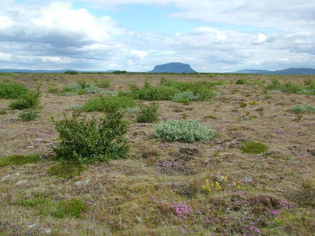
Areas to be replanted are pre-selected based on local conditions and optimal rates of potential seed dispersal (prevailing dry-wind direction, distance to remnant seed banks etc.). The areas are partially vegetated or have previously been treated with fertilizer (and seed) to facilitate surface stabilization, improved soil qualities and vegetation succession. Only native species are planted in these seed bank "islands": mainly birch and a mixture of willow species. The islands/patches are scattered within the restoration area in order to maximise the effectiveness of the technology in the long term.
Purpose of the Technology: The purpose of the technology is to halt further land degradation and facilitate natural succession within the area undergoing restoration. In the long-term, it should substantially reduce wind and water erosion. It should also lead to increased biodiversity, enhanced water availability and accelerated carbon sequestration (in soil and vegetation). The overall restoration task is to increase the resilience of the ecosystems against natural hazards, such as volcanic activity.
Establishment / maintenance activities and inputs: For the first years, the plants in the seed banks islands are treated annually with a small amount of fertilizer. The nutrient level within the areas is still very low and barely enough to support adequate annual plant growth.
Natural / human environment: In the long-term, the technology is expected to substantially increase biomass production, re-build soil qualities, accelerate carbon sequestration and secure water availability within the rangeland and the adjacent ecosystems. Increased tree and diverse vegetation cover will have the effect of reducing and even halting the sand drift that still creates challenges for inhabitants in adjacent villages, on farmsteads and within the summerhouse clusters, scattered around the area. As the degraded rangeland is in the vicinity of an active volcano (Mt Hekla) the technology is also expected to increase ecosystem resilience against natural hazards like ash and pumice drift and reduce potential offsite damage caused by these materials. Planting areas are pre-selected based on local conditions and optimal rate of potential seed dispersal (prevailing dry-wind direction, distance to remnant seed banks etc.). The areas are partially vegetated or have previously been treated with fertilizer (and seed) to facilitate surface stabilization, improved soil qualities and vegetation succession. Only native species are planted in these seed bank "islands"; mainly birch and a mixture of willow species. The islands/patches are scattered within the restoration area in order to maximise the effectiveness of the technology in the long-term.
2.3 រូបភាពនៃបច្ចេកទេស
វិចិត្រសាលប្រព័ន្ធផ្សព្វផ្សាយ

2.5 ប្រទេស/តំបន់/ទីតាំងកន្លែង ដែលបច្ចេកទេសត្រូវបានអនុវត្ត និងបានគ្រប់ដណ្តប់ដោយការវាយតម្លៃនេះ
ប្រទេស:
ប្រទេសអ៊ីស្លង់
តំបន់/រដ្ឋ/ខេត្ត:
Rangarthing Ytra
បញ្ជាក់បន្ថែមពីលក្ខណៈនៃទីតាំង:
Rangarvellir
មតិយោបល់:
Total area covered by the SLM Technology is 900 km2.
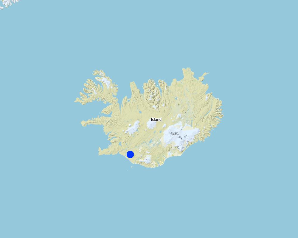
Map
×2.6 កាលបរិច្ឆេទនៃការអនុវត្ត
ប្រសិនបើមិនច្បាស់ឆ្នាំ សូមបញ្ជាក់កាលបរិច្ឆេទដែលប្រហាក់ប្រហែល:
- 10-50 ឆ្នាំ
2.7 ការណែនាំពីបច្ចេកទេស
សូមបញ្ជាក់តើបច្ចេកទេសត្រូវបានណែនាំឱ្យអនុវត្តដោយរបៀបណា:
- ពេលកំពុងពិសោធន៍
3. ចំណាត់ថ្នាក់នៃបច្ចេកទេស SLM
3.1 គោលបំណងចម្បង (១ ឬច្រើន) នៃបច្ចេកទេសនេះ
- កាត់បន្ថយ, បង្ការ, ស្តារឡើងវិញនូវការធ្លាក់ចុះគុណភាពដី
- អភិរក្សប្រព័ន្ធអេកូឡូស៊ី
- អភិរក្ស/ធ្វើឱ្យប្រសើរឡើងជីវចម្រុះ
- កាត់បន្ថយហានិភ័យនៃគ្រោះមហន្តរាយ
3.2 ប្រភេទដីប្រើប្រាស់មួយប្រភេទ (ច្រើនប្រភេទ) ដែលបានអនុវត្តបច្ចេកទេស

ដីព្រៃ/ដីដាំដើមឈើ
ផលិតផល និងសេវាកម្ម:
- ការអភិរក្ស/ការការពារធម្មជាតិ
- ការកំសាន្ត/ទេសចរណ៍
- ការពារពីគ្រោះធម្មជាតិ

ដីខ្សោះជីជាតិ
សូមបញ្ជាក់:
Wastelands, deserts, glaciers, swamps, recreation areas, etc
មតិយោបល់:
Major land use problems (compiler’s opinion): Vast parts of the area are heavily degraded due to unsustainable land use through the centuries in combination to harsh climate and frequent volcanic eruptions. The major land use problem are related to the fact that the concerned ecosystems collapsed long time ago and despite all restoration efforts implemented within the area for over 100 years, the systems are still highly dysfunctional. Their carrying capacity is limited and even light livestock grazing can keep further vegetation succession down. Passive restoration might take place where the livestock grazing has been excluded but in most cases some technologies are needed to "kickstart" the ecosystem and break their negative resilience against changes.
Major land use problems (land users’ perception): They are fully aware that the ecosystems are in a poor condition and restoration is needed in order to push improvements forward. They acknowledge that grazing of collapsed ecosystems can maintain the dysfunctional of the systems and hinder ecological improvements. Nevertheless, in many cases they believe the harsh climate and volcanic activities are the main contributors to land degradation - that livestock grazing and the grazing carrying capacity of the rangeland are not fundamental issues in this context.
Future (final) land use (after implementation of SLM Technology): Forests / woodlands: Fn: Natural
Constraints of wastelands / deserts / glaciers / swamps
Number of growing seasons per year: 1
Longest growing period from month to month: June to end August
3.3 បន្ទាប់ពីអនុវត្តបច្ចេកទេស តើដីប្រើប្រាស់មានការប្រែប្រួលដែររឺទេ?
បន្ទាប់ពីអនុវត្តបច្ចេកទេស តើដីប្រើប្រាស់មានការប្រែប្រួលដែររឺទេ?
- បាទ/ច៎ា (សូមបំពេញសំណួរខាងក្រោមពីស្ថានភាពដីប្រើប្រាស់មុនពេលអនុវត្តបច្ចេកទេស)
ដីខ្សោះជីជាតិ
សូមបញ្ជាក់:
Wastelands, deserts, glaciers, swamps, recreation areas, etc
3.4 ការផ្គត់ផ្គង់ទឹក
ការផ្គត់ផ្គង់ទឹកនៅកន្លែងអនុវត្តបច្ចេកទេស:
- ទឹកភ្លៀង
3.5 ក្រុម SLM ដែលបច្ចេកទេសស្ថិតនៅក្នុង
- ធ្វើឱ្យប្រសើរឡើងគម្របដី/ ដំណាំគម្របដី
- កាត់បន្ថយហានិភ័យនៃបញ្ហាលើប្រព័ន្ធអេកូឡូស៊ី
3.6 វិធានការ SLM ដែលបញ្ចូលនូវបច្ចេកទេស

វិធានការរុក្ខជាតិ
- V1: ឈើធំៗ និងដើមឈើតូចៗ

វិធានការគ្រប់គ្រង
- M1: ការផ្លាស់ប្តូរប្រភេទដីប្រើប្រាស់
មតិយោបល់:
Main measures: vegetative measures, management measures
Type of vegetative measures: aligned: -against wind, scattered / dispersed
3.7 កំណត់ប្រភេទនៃការធ្លាក់ចុះគុណភាពដីសំខាន់ៗដែលបច្ចេកទេសនេះបានដោះស្រាយ

ការធ្លាក់ចុះជីវសាស្ត្រនៃដី
- Bc: ការថយចុះនូវគម្របរុក្ខជាតិ
- Bq: ការថយចុះនូវជីវម៉ាស/ បរិមាណ
- Bs: សមាសភាពដែលមានគុណភាពនិងប្រភេទសត្វ/ការថយចុះនូវជីវចម្រុះ

ការបាត់បង់ទឹក
- Hs: ការប្រែប្រួលបរិមាណទឹកនៅលើផ្ទៃដី
- Hg: ការប្រែប្រួលបរិមាណទឹកនៅក្រោមដី
មតិយោបល់:
Secondary types of degradation addressed: Bc: reduction of vegetation cover, Bq: quantity / biomass decline, Bs: quality and species composition /diversity decline, Hs: change in quantity of surface water, Hg: change in groundwater / aquifer level
Main causes of degradation: deforestation / removal of natural vegetation (incl. forest fires), over-exploitation of vegetation for domestic use, overgrazing, Heavy / extreme rainfall (intensity/amounts), wind storms / dust storms, other natural causes (avalanches, volcanic eruptions, mud flows, highly susceptible natural resources, extreme topography, etc.) specify
Secondary causes of degradation: disturbance of water cycle (infiltration / runoff), change in temperature, floods, land tenure, governance / institutional
3.8 ការពារ កាត់បន្ថយ ឬស្តារឡើងវិញនៃការធ្លាក់ចុះគុណភាពដី
បញ្ជាក់ពីគោលដៅរបស់បច្ចេកទេស ដែលផ្តោតទៅការធ្លាក់ចុះគុណភាពដី:
- ការកាត់បន្ថយការធ្លាក់ចុះគុណភាពដី
- ការជួសជុល/ ស្តារឡើងវិញនៃឱនភាពដីធ្ងន់ធ្ងរ
មតិយោបល់:
Main goals: mitigation / reduction of land degradation, rehabilitation / reclamation of denuded land
Secondary goals: prevention of land degradation
4. បច្ចេកទេសជាក់លាក់ សកម្មភាពអនុវត្ត ធាតុចូល និងថ្លៃដើម
4.1 គំនូសបច្ចេកទេសនៃបច្ចេកទេសនេះ
លក្ខណៈពិសេសនៃបច្ចេកទេស (ទាក់ទងនឺងគំនូរបច្ចេកទេស):
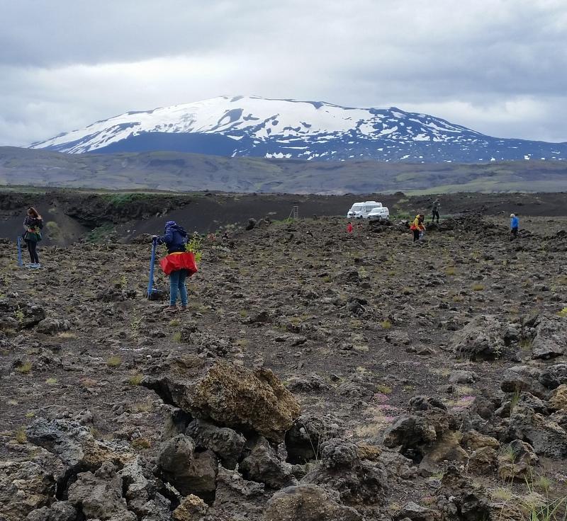
An example showing the development of a local seed bank at a previously eroded area.
Location: South Iceland
Technical knowledge required for field staff / advisors: high
Technical knowledge required for land users: moderate
Main technical functions: improvement of ground cover, increase of surface roughness, improvement of topsoil structure (compaction), increase in organic matter, increase in nutrient availability (supply, recycling,…), increase of infiltration, increase / maintain water stored in soil, increase of groundwater level / recharge of groundwater, water harvesting / increase water supply, water spreading, improvement of water quality, buffering / filtering water, sediment retention / trapping, sediment harvesting, reduction in wind speed, increase of biomass (quantity)
Secondary technical functions: control of raindrop splash, control of dispersed runoff: retain / trap, control of dispersed runoff: impede / retard, control of concentrated runoff: impede / retard, control of concentrated runoff: drain / divert, stabilisation of soil (eg by tree roots against land slides), promotion of vegetation species and varieties (quality, eg palatable fodder), spatial arrangement and diversification of land use
Aligned: -against wind
Vegetative material: T : trees / shrubs
Scattered / dispersed
Vegetative material: T : trees / shrubs
Trees/ shrubs species: birch and several willow species planted to facilitate natural regeneration of native trees and shrubs
Change of land use type: Protected from sheep grazing
ឈ្មោះអ្នកនិពន្ធ:
Áskell Þórisson
4.2 ព័ត៌មានទូទៅដែលពាក់ព័ន្ធនឹងការគណនាធាតុចូល និងថ្លៃដើម
ផ្សេងៗ/ រូបិយប័ណ្ណជាតិ (បញ្ជាក់):
ISK
បើពាក់ព័ន្ធសូមកំណត់អត្រាប្តូរប្រាក់ពីដុល្លាទៅរូបិយប័ណ្ណតំបន់ (ឧ. 1 ដុល្លារ = 79.9 រៀលនៃរូបិយប័ណ្ណប្រេស៊ីល) ៖ 1 ដុល្លារ =:
138,0
4.3 សកម្មភាពបង្កើត
| សកម្មភាព | រយៈពេល (រដូវកាល) | |
|---|---|---|
| 1. | Planting seedlings | May/June |
4.4 ថ្លៃដើម និងធាតុចូលដែលត្រូវការសម្រាប់ការបង្កើតបច្ចេកទេស
| បញ្ជាក់ពីធាតុចូល | ឯកតា | បរិមាណ | ថ្លៃដើមក្នុងមួយឯកតា | ថ្លៃធាតុចូលសរុប | % នៃថ្លៃដើមដែលចំណាយដោយអ្នកប្រើប្រាស់ដី | |
|---|---|---|---|---|---|---|
| កម្លាំងពលកម្ម | Planting | |||||
| សម្ភារៈ | Machinery | |||||
| សម្ភារៈដាំដុះ | Seedlings | |||||
| ផ្សេងៗ | Total costs | ha | 1,0 | 500000,0 | 500000,0 | |
| ថ្លៃដើមសរុបក្នុងការបង្កើតបច្ចេកទេស | 500000,0 | |||||
| ថ្លៃដើមសរុបក្នុងការបង្កើតបច្ចេកទេសគិតជាដុល្លារ | 3623,19 | |||||
4.7 កត្តាសំខាន់បំផុតដែលមានឥទ្ធិពលដល់ការចំណាយ
ពណ៌នាពីកត្តាប៉ះពាល់ចម្បងៗទៅលើថ្លៃដើម:
The most determinate factors affecting the cost are a) the distance from the farmsteads to the eroded areas and b) the time it takes to plant the seedlings; easily accessible areas vs difficult areas
5. លក្ខណៈបរិស្ថានធម្មជាតិ និងមនុស្ស
5.1 អាកាសធាតុ
បរិមាណទឹកភ្លៀងប្រចាំឆ្នាំ
- < 250 មម
- 251-500 មម
- 501-750 មម
- 751-1,000 មម
- 1,001-1,500 មម
- 1,501-2,000 មម
- 2,001-3,000 មម
- 3,001-4,000 មម
- > 4,000 មម
តំបន់កសិអាកាសធាតុ
- មានភ្លៀងមធ្យម
- មានភ្លៀងតិចតួច
Thermal climate class: boreal
Thermal climate class: polar/arctic
5.2 សណ្ឋានដី
ជម្រាលជាមធ្យម:
- រាបស្មើ (0-2%)
- ជម្រាលតិចតួច (3-5%)
- មធ្យម (6-10%)
- ជម្រាលខ្ពស់បន្តិច (11-15%)
- ទីទួល (16-30%)
- ទីទួលចោត (31-60%)
- ទីទួលចោតខ្លាំង (>60%)
ទម្រង់ដី:
- ខ្ពង់រាប
- កំពូលភ្នំ
- ជម្រាលភ្នំ
- ជម្រាលទួល
- ជម្រាលជើងភ្នំ
- បាតជ្រលងភ្នំ
តំបន់តាមរយៈកម្ពស់ :
- 0-100 ម
- 101-500 ម
- 501-1,000 ម
- 1,001-1,500 ម
- 1,501-2,000 ម
- 2,001-2,500 ម
- 2,501-3,000 ម
- 3,001-4,000 ម
- > 4,000 ម
បញ្ជាក់ថាតើបច្ចេកទេសនេះត្រូវបានអនុវត្តន៍នៅក្នុង:
- មិនពាក់ព័ន្ធទាំងអស់
5.3 ដី
ជម្រៅដីជាមធ្យម:
- រាក់ខ្លាំង (0-20 សម)
- រាក់ (21-50 សម)
- មធ្យម (51-80 សម)
- ជ្រៅ (81-120 សម)
- ជ្រៅខ្លាំង (> 120 សម)
វាយនភាពដី (ស្រទាប់លើ):
- គ្រើម/ មានពន្លឺ (ខ្សាច់)
វាយនភាពដី (> 20 សម ស្រទាប់ក្នុង):
- គ្រើម/ មានពន្លឺ (ខ្សាច់)
សារធាតុសរីរាង្គនៅស្រទាប់ដីខាងលើ:
- មធ្យម (1-3%)
- ទាប (<1%)
បើអាចសូមភ្ជាប់ការពណ៌នាពីដីឱ្យបានច្បាស់ ឬព័ត៌មានដែលអាចទទួលបាន ឧ. ប្រភេទដី, pH ដី/ ជាតិអាស៊ីត, សមត្ថភាពផ្លាស់ប្តូរកាចុង, វត្តមាននីត្រូសែន, ភាពប្រៃ ។ល។:
Soil fertility is very low-low to medium
Soil drainage/infiltration is poor to medium
Soil water sotrage capacity is very low to medium
5.4 ទឹកដែលអាចទាញមកប្រើប្រាស់បាន និងគុណភាពទឹក
នីវ៉ូទឹកក្រោមដី:
< 5 ម
ទឹកលើដីដែលអាចទាញយកប្រើប្រាស់បាន:
មិនមាន/ គ្មាន
គុណភាពទឹក (មិនបានធ្វើប្រត្តិកម្ម):
ទឹកពិសារដែលមានគុណភាពល្អ
គុណភាពទឹក គឺផ្តោតទៅលើ៖:
ទឹកក្រោមដី
តើមានបញ្ហាភាពទឹកប្រៃហូរចូលមកដែរឬទេ?
ទេ
តើទឹកជំនន់កំពុងកើតមាននៅតំបន់នេះដែររឺទេ?
ទេ
5.5 ជីវៈចម្រុះ
ភាពសម្បូរបែបនៃប្រភេទ:
- ទាប
ភាពសម្បូរបែបនៃទីជម្រក:
- ទាប
5.6 លក្ខណៈនៃអ្នកប្រើប្រាស់ដីដែលអនុវត្តបច្ចេកទេស
នៅមួយកន្លែង ឬពនេចរ :
- នៅមួយកន្លែង
ទីផ្សារនៃប្រព័ន្ធផលិតកម្ម:
- សម្រាប់ហូបក្នុងគ្រួសារ (ផ្គត់ផ្គង់ខ្លួនឯង)
ចំណូលក្រៅកសិកម្ម:
- 10-50% នៃចំណូល
កម្រិតជីវភាព:
- មាន
ឯកជន ឬក្រុម:
- ជាក្រុម/ សហគមន៍
កម្រិតប្រើប្រាស់គ្រឿងយន្ត:
- ប្រើកម្លាំងពលកម្ម
- គ្រឿងយន្ត/ ម៉ាស៊ីន
យេនឌ័រ:
- ស្ត្រី
- បុរស
អាយុរបស់អ្នកប្រើប្រាស់ដី:
- វ័យកណ្តាល
សូមបញ្ជាក់ពីលក្ខណៈពាក់ព័ន្ធផ្សេងទៀតអំពីអ្នកប្រើប្រាស់ដី:
Land users applying the Technology are mainly common / average land users
Population density: < 10 persons/km2
5.7 ទំហំផ្ទៃដីជាមធ្យមនៃដីប្រើប្រាស់ដោយអ្នកប្រើប្រាស់ដី ក្នុងការអនុវត្តបច្ចេកទេស
- < 0.5 ហិកតា
- 0.5-1 ហិកតា
- 1-2 ហិកតា
- 2-5 ហិកតា
- 5-15 ហិកតា
- 15-50 ហិកតា
- 50-100 ហិកតា
- 100-500 ហិកតា
- 500-1,000 ហិកតា
- 1,000-10,000 ហិកតា
- > 10,000 ហិកតា
តើផ្ទៃដីនេះចាត់ទុកជាទំហំកម្រិតណាដែរ ខ្នាតតូច មធ្យម ឬខ្នាតធំ (ធៀបនឹងបរិបទតំបន់)?
- ខ្នាតតូច
5.8 ភាពជាម្ចាស់ដី កម្មសិទ្ធប្រើប្រាស់ដី និងកម្មសិទ្ធប្រើប្រាស់ទឹក
ភាពជាម្ចាស់ដី:
- រដ្ឋ
កម្មសិទ្ធិប្រើប្រាស់ដី:
- ជាក្រុម (មានដែនកំណត់)
កម្មសិទ្ធប្រើប្រាស់ទឹក:
- អាស្រ័យផលសេរី (មិនមានការកំណត់)
តើកម្មសិទ្ធប្រើប្រាស់ដី គឺផ្អែកលើប្រព័ន្ធច្បាប់បែបបុរាណ?
បាទ/ចា៎
5.9 ការប្រើប្រាស់សេវាកម្ម និងហេដ្ឋារចនាសម្ព័ន្ធ
សុខភាព:
- មិនល្អ
- មធ្យម
- ល្អ
ការអប់រំ:
- មិនល្អ
- មធ្យម
- ល្អ
ជំនួយបច្ចេកទេស:
- មិនល្អ
- មធ្យម
- ល្អ
ការងារ (ឧ. ការងារក្រៅកសិដ្ឋាន):
- មិនល្អ
- មធ្យម
- ល្អ
ទីផ្សារ:
- មិនល្អ
- មធ្យម
- ល្អ
ថាមពល:
- មិនល្អ
- មធ្យម
- ល្អ
ផ្លូវ និងការដឹកជញ្ជូន:
- មិនល្អ
- មធ្យម
- ល្អ
ទឹកផឹក និងអនាម័យ:
- មិនល្អ
- មធ្យម
- ល្អ
សេវាកម្មហិរញ្ញវត្ថុ:
- មិនល្អ
- មធ្យម
- ល្អ
6. ផលប៉ះពាល់ និងការសន្និដ្ឋាន
6.1 ផលប៉ះពាល់ក្នុងបរិវេណអនុវត្តបច្ចេកទេសដែលកើតមាន
ផលប៉ះពាល់លើសេដ្ឋកិច្ចសង្គម
ទឹកដែលអាចទាញមកប្រើប្រាស់បាន និងគុណភាពទឹក
ទឹកបរិភោគដែលអាចទាញយកមកប្រើប្រាស់បាន
ទឹកដែលអាចប្រើប្រាស់បានសម្រាប់ការចិញ្ចឹមសត្វ
គុណភាពទឹកសម្រាប់ការចិញ្ចឹមសត្វ
ផលប៉ះពាល់ទៅលើសេដ្ឋកិច្ចសង្គមផ្សេងៗ
Land price/lease
ផលប៉ះពាល់ទៅលើវប្បធម៌សង្គម
ឱកាសវប្បធម៍
ឱកាសនៃការបង្កើតថ្មី
ស្ថាប័នសហគមន៍
ស្ថាប័នជាតិ
ចំណេះដឹង SLM / ការធ្លាក់ចុះគុណភាពដី
ផលប៉ះពាល់ទៅលើអេកូឡូស៊ី
វដ្តទឹក/លំហូរ
បរិមាណទឹក
គុណភាពទឹក
ការប្រមូលស្តុកទុកទឹក
លំហូរទឹកលើផ្ទៃដី
ប្រព័ន្ធបង្ហូរទឹក
នីវ៉ូទឹកក្រោមដី/ ដង្ហើមទឹក
រំហួត
ដី
សំណើមដី
គម្របដី
ការបាត់បង់ដី
វដ្តនៃសារធាតុចិញ្ចឹម/ការទទួលបាន
សារធាតុសរីរាង្គដី/ការបូនក្រោមដី
ជីវចម្រុះ៖ ដំណាំ, សត្វ
ជីវម៉ាស/ កាបូនលើដី
ភាពសម្បូរបែបនៃរុក្ខជាតិ
ភាពសម្បូរបែបនៃសត្វ
ភាពសម្បូរបែបនៃទីជំរក
ការកាត់បន្ថយហានិភ័យនៃគ្រោះមហន្តរាយ និងគ្រោះអាកាសធាតុ
ការបំភាយនៃកាបូន និងឧស្ម័នផ្ទះកញ្ចក់
ល្បឿនខ្យល់
6.2 ផលប៉ះពាល់ក្រៅបរិវេណអនុវត្តបច្ចេកទេសដែលកើតមាន
ទឹកដែលអាចទាញមកប្រើប្រាស់បាន
ទឹកជំនន់ខ្សែទឹកខាងក្រោម
កំណកល្បាប់ខ្សែទឹកខាងក្រោម
Buffering/សមត្ថភាពចម្រោះ
ខ្យល់នាំយកនូវធូរលី
ខូចខាតដល់ស្រែអ្នកជិតខាង
ខូចខាតដល់ហេដ្ឋារចនាសម្ព័ន្ធសាធារណៈ/ឯកជន
6.3 ភាពប្រឈម និងភាពរួសនៃបច្ចេកទេសទៅនឹងការប្រែប្រួលអាកាសធាតុ និងគ្រោះអាកាសធាតុ/ គ្រោះមហន្តរាយ (ដែលដឹងដោយអ្នកប្រើប្រាស់ដី)
ការប្រែប្រួលអាកាសធាតុ
ការប្រែប្រួលអាកាសធាតុ
| រដូវកាល | កើនឡើង ឬថយចុះ | លក្ខណៈឆ្លើយតបនៃបច្ចេកទេសទៅនឹងការប្រែប្រួលអាកាសធាតុ | |
|---|---|---|---|
| សីតុណ្ហភាពប្រចាំឆ្នាំ | កើនឡើង | ល្អ |
គ្រោះអាកាសធាតុ (មហន្តរាយ)
គ្រោះមហន្តរាយធម្មជាតិ
| លក្ខណៈឆ្លើយតបនៃបច្ចេកទេសទៅនឹងការប្រែប្រួលអាកាសធាតុ | |
|---|---|
| ព្យុះកំបុតត្បូងតាមតំបន់ | ល្អ |
គ្រោះមហន្តរាយអាកាសធាតុ
| លក្ខណៈឆ្លើយតបនៃបច្ចេកទេសទៅនឹងការប្រែប្រួលអាកាសធាតុ | |
|---|---|
| រាំងស្ងួត | មិនល្អ |
គ្រោះមហន្តរាយទឹក
| លក្ខណៈឆ្លើយតបនៃបច្ចេកទេសទៅនឹងការប្រែប្រួលអាកាសធាតុ | |
|---|---|
| ទឹកជំនន់ទូទៅ (ទន្លេ) | ល្អ |
ផលវិបាកដែលទាក់ទងនឹងបរិយាកាសផ្សេងៗទៀត
ផលវិបាកដែលទាក់ទងនឹងបរិយាកាសផ្សេងៗទៀត
| លក្ខណៈឆ្លើយតបនៃបច្ចេកទេសទៅនឹងការប្រែប្រួលអាកាសធាតុ | |
|---|---|
| កាត់បន្ថយពេលដាំដុះ | ល្អ |
6.4 ការវិភាគថ្លៃដើម និងអត្ថប្រយោជន៍
តើផលចំណេញ និងថ្លៃដើមត្រូវបានប្រៀបធៀបគ្នាយ៉ាងដូចម្តេច (ទស្សនៈរបស់អ្នកប្រើប្រាស់ដី)?
រយៈពេលខ្លី:
វិជ្ជមាន
រយៈពេលវែង:
វិជ្ជមានខ្លាំង
តើផលចំណេញ និងការថែទាំ/ ជួសជុលត្រូវបានប្រៀបធៀបគ្នាយ៉ាងដូចម្តេច (ទស្សនៈរបស់អ្នកប្រើប្រាស់ដី)?
រយៈពេលខ្លី:
វិជ្ជមានខ្លាំង
រយៈពេលវែង:
វិជ្ជមានខ្លាំង
6.5 ការទទួលយកបច្ចេកទេស
- 11-50%
ក្នុងចំណោមគ្រួសារទាំងអស់ដែលបានអនុវត្តបច្ចេកទេស តើមានប៉ុន្មានគ្រួសារដែលចង់ធ្វើដោយខ្លួនឯង ដោយមិនទទួលបានសម្ភារៈលើកទឹកចិត្ត/ប្រាក់ឧបត្ថម្ភ?:
- 0-10%
6.6 ការបន្សុំា
តើថ្មីៗនេះ បច្ចេកទេសនេះត្រូវបានកែតម្រូវដើម្បីបន្ស៊ាំទៅនឹងស្ថានភាពប្រែប្រួលដែរឬទេ?
បាទ/ចា៎
ផ្សេងៗ (សូមបញ្ជាក់):
climate
បញ្ជាក់ពីការបន្ស៊ាំនៃបច្ចេកទេស (ការរៀបចំ, ឧបករណ៍/ប្រភេទ ។ល។):
using of local birch trees
freezing the seadlings (after planting the plants have some water to grow and they can't lose water through evaporation, start growing when the conditions are good for them) --> much better succes
6.7 ភាពខ្លាំង/ គុណសម្បត្តិ/ ឱកាសនៃបច្ចេកទេស
| ភាពខ្លាំង/ គុណសម្បត្តិ/ ឱកាសនៅកន្លែងរបស់អ្នកប្រើប្រាស់ដី |
|---|
| Trees are less vulnerable to ash falls after volcanic eruptions. |
| The astetic view of landscape is increasing. |
| The trees can store carbon. |
| ភាពខ្លាំង/ គុណសម្បត្តិ/ ឱកាស ទស្សនៈរបស់បុគ្គលសំខាន់ៗ |
|---|
| Trees are less vulnerable to ash falls after volcanic eruptions. |
| The astetic view of landscape is increasing. |
| Native Icelandic plants are used. |
| The trees can store carbon. |
6.8 ភាពខ្សោយ/ គុណវិបត្តិ/ ហានិភ័យនៃបច្ចេកទេស និងវិធីសាស្ត្រដោះស្រាយ
| ភាពខ្សោយ/ គុណវិបត្តិ/ ហានិភ័យ ទស្សនៈរបស់អ្នកប្រើប្រាស់ដី | តើបច្ចេកទេសទាំងនោះបានដោះស្រាយបញ្ហាដូចម្តេច? |
|---|---|
| It covers land who could be used for other things (grazing). | Explain advantages of restore land and save it from wind erosion |
| ភាពខ្សោយ/ គុណវិបត្តិ/ ហានិភ័យ ទស្សនៈរបស់អ្នកចងក្រងឬបុគ្គលសំខាន់ៗ | តើបច្ចេកទេសទាំងនោះបានដោះស្រាយបញ្ហាដូចម្តេច? |
|---|---|
| The soil in certain locations must first be prepared. | Through land reclamation activities the soil can be improved. (fertilized and stabilized) |
7. ឯកសារយោង និងវេបសាយ
7.1 វិធីសាស្ត្រ/ ប្រភពនៃព័ត៌មាន
- តាមការចុះទីវាល ការស្រាវជ្រាវនៅទីវាល
- ការសម្ភាសន៍ជាមួយអ្នកប្រើប្រាស់ដី
- ការសម្ភាសន៍ជាមួយអ្នកជំនាញ/ ឯកទេស
- ការចងក្រងពីរបាកការណ៍ និងឯកសារផ្សេងៗទៀតដែលមាន
7.3 ការភ្ជាប់ទៅកាន់ព័ត៌មានពាក់ព័ន្ធលើប្រព័ន្ធអនឡាញ
ចំណងជើង/ ពណ៌នា:
Webpage Soil Conservation Service of Iceland
វេបសាយ:
https://land.is/english/
ការតភ្ជាប់ និងម៉ូឌុល
ពង្រីកមើលទាំងអស់ បង្រួមទាំងអស់ការតភ្ជាប់
គ្មានការតភ្ជាប់
ម៉ូឌុល
គ្មានម៉ូឌុល