Soil and Water Conservation Channels [អ៊ូហ្គង់ដា]
- ការបង្កើត៖
- បច្ចុប្បន្នភាព
- អ្នកចងក្រង៖ Philip Tibenderana
- អ្នកកែសម្រួល៖ Mirjam Nufer
- អ្នកត្រួតពិនិត្យច្រើនទៀត៖ Alexandra Gavilano, Hanspeter Liniger, Nicole Harari
Emirongooti
technologies_711 - អ៊ូហ្គង់ដា
ពិនិត្យមើលគ្រប់ផ្នែក
ពង្រីកមើលទាំងអស់ បង្រួមទាំងអស់1. ព័ត៌មានទូទៅ
1.2 ព័ត៌មានលម្អិតពីបុគ្គលសំខាន់ៗ និងស្ថាប័នដែលចូលរួមក្នុងការវាយតម្លៃ និងចងក្រងឯកសារនៃបច្ចេកទេស
បុគ្គលសំខាន់ម្នាក់ (ច្រើននាក់)
អ្នកជំនាញឯកទេស SLM:
ឈ្មោះគម្រោងដែលបានចងក្រងឯកសារ/ វាយតម្លៃលើបច្ចេកទេស (បើទាក់ទង)
Book project: where people and their land are safer - A Compendium of Good Practices in Disaster Risk Reduction (DRR) (where people and their land are safer)ឈ្មោះអង្គភាពមួយ (ច្រើន) ដែលបានចងក្រងឯកសារ/ វាយតម្លៃបច្ចេកទេស (បើទាក់ទង)
Tear Fund Switzerland (Tear Fund Switzerland) - ប្រទេសស្វ៊ីស1.3 លក្ខខណ្ឌទាក់ទងទៅនឹងការប្រើប្រាស់ទិន្នន័យដែលបានចងក្រងតាមរយៈ វ៉ូខេត
អ្នកចងក្រង និង(បុគ្គលសំខាន់ៗ)យល់ព្រមទទួលយកនូវលក្ខខណ្ឌនានាទាក់ទងទៅនឹងការប្រើប្រាស់ទិន្នន័យដែលបានចងក្រងតាមរយៈវ៉ូខេត:
បាទ/ចា៎
1.4 សេចក្តីប្រកាសស្តីពីចីរភាពនៃការពណ៌នាពីបច្ចេកទេស
តើបច្ចេកទេសដែលបានពណ៌នានេះមានបញ្ហាដែលផ្តោតលើការធ្លាក់ចុះគុណភាពដី, បើដូច្នេះវាមិនអាចត្រូវបានប្រកាសថាជាបច្ចេកទេសនៃការគ្រប់គ្រងប្រកបដោយចីរភាពទេ?
ទេ
មតិយោបល់:
So far, where this technology has been applied, the water runoff has been reduced, water retention increased and soils trapped
1.5 ការយោងទៅលើកម្រងបញ្ជីសំណួរ (មួយ ឬច្រើន) នៃវិធីសាស្ត្រផ្សព្វផ្សាយ SLM (ដែលបានចងក្រងដោយទស្សនៈពិភពលោកស្តីពីវិធីសាស្ត្រ និងបច្ចេកទេសងអភិរក្ស WOCAT)
Catchment Based Integrated Water Resources Management [អ៊ូហ្គង់ដា]
Catchment based integrated water resources management is a process which promotes the coordinated development and management of water, land and related resources in order to maximise economic and social welfare in an equitable manner without compromising the sustainability of vital eco systems
- អ្នកចងក្រង៖ Philip Tibenderana
2. ការពណ៌នាពីបច្ចេកទេស SLM
2.1 ការពណ៌នាដោយសង្ខេបពីបច្ចេកទេស
និយមន័យបច្ចេកទេស:
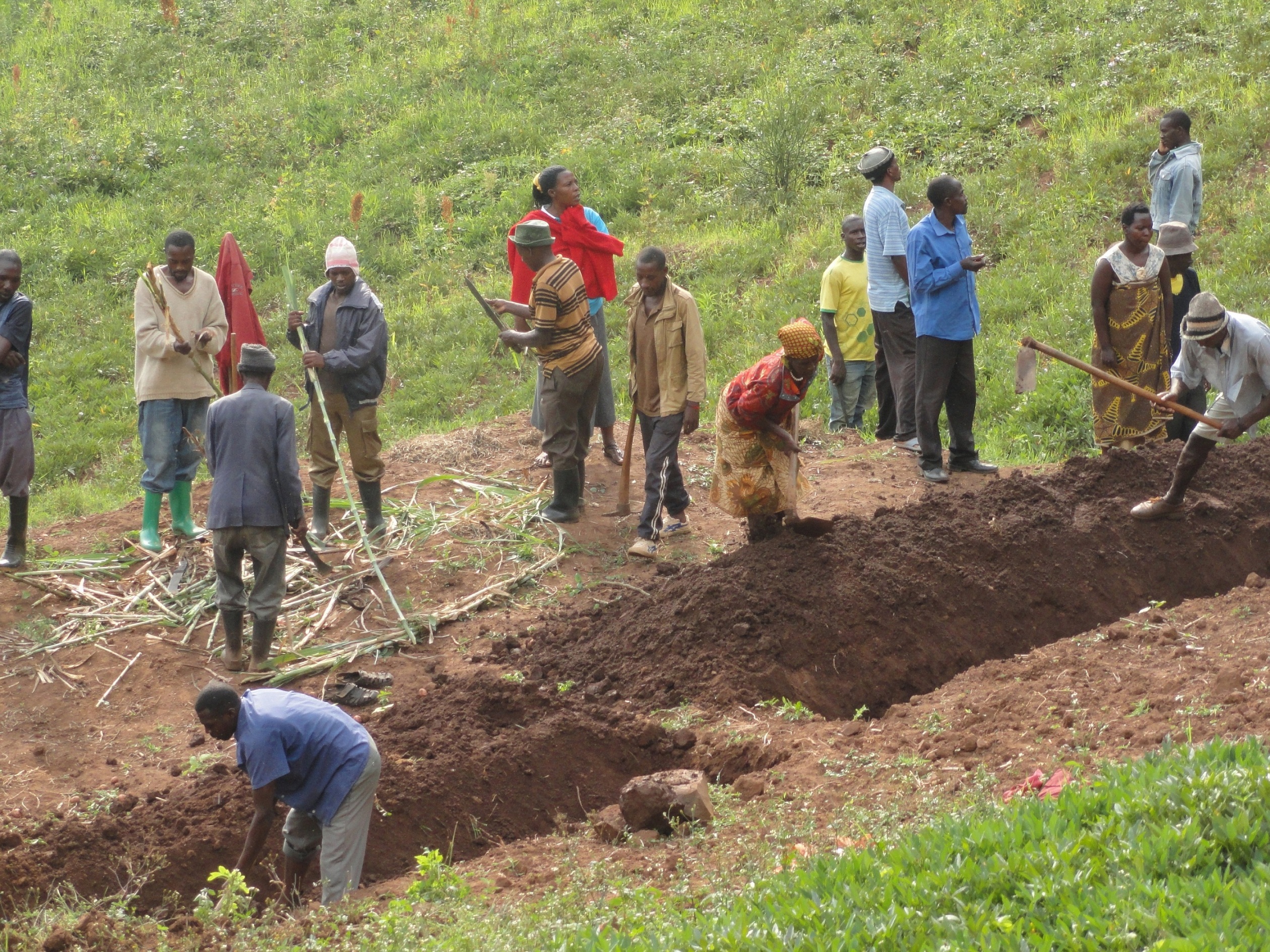
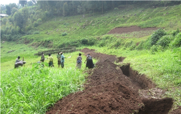
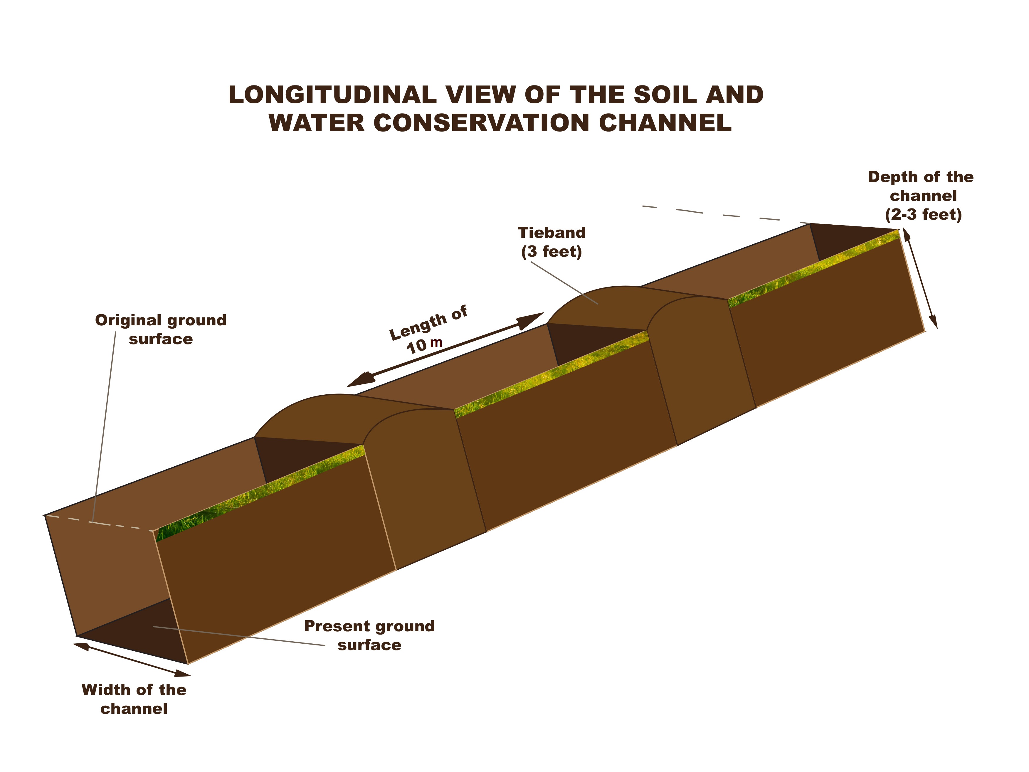
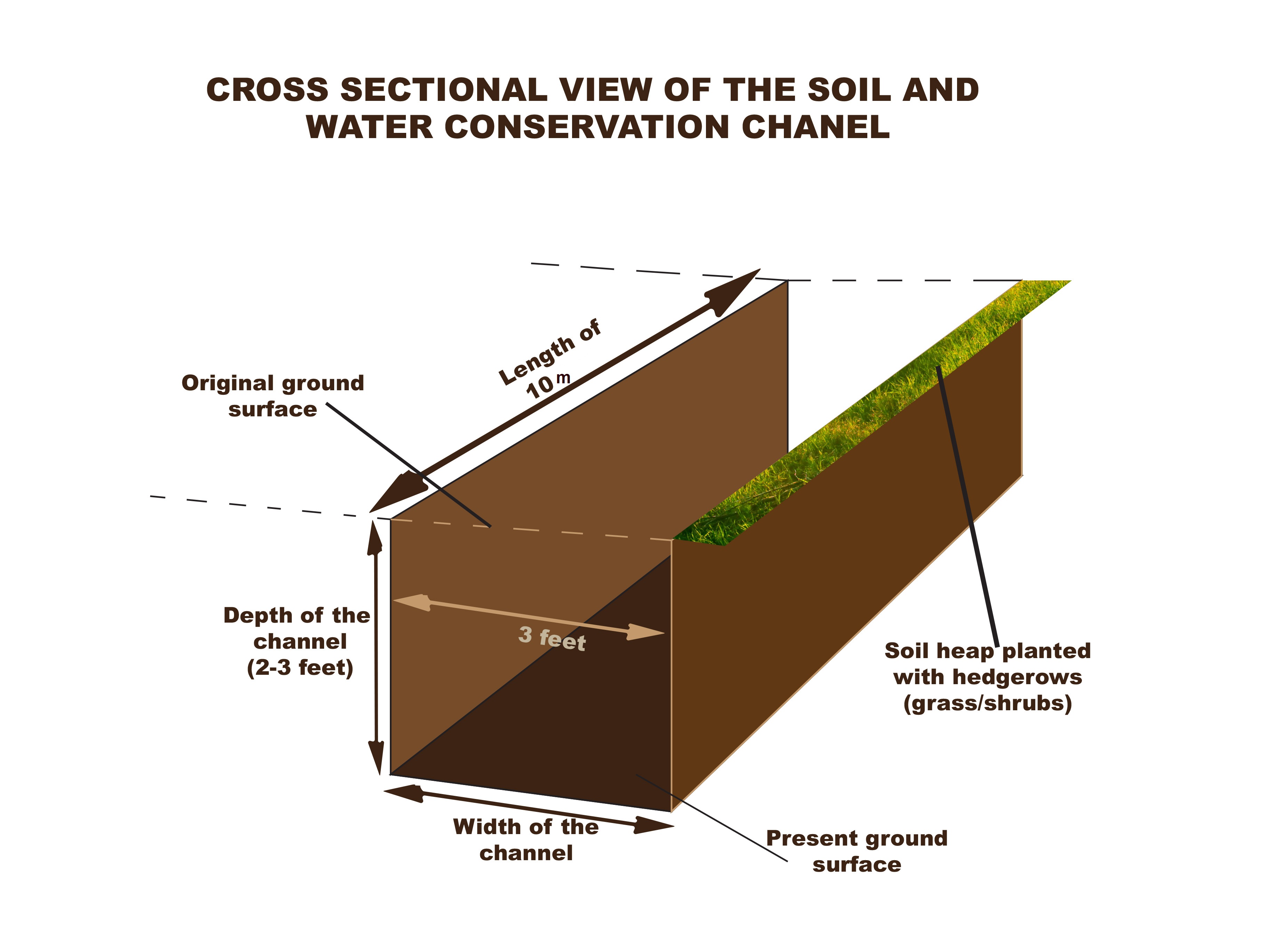
A soil and water conservation channel is an excavated trench along the contour with tie bands after an interval to trap water and soil which are being washed down the slopes by a downpour
2.2 ការពណ៌នាលម្អិតពីបច្ចេកទេស
ការពណ៌នា:
The technology is applied in already existing degraded farmlands, which are individually owned. An average farm size is less than half an acre.
A typical soil and water conservation channel is a trench 1m wide, 1m deep and with tie bands (1m wide to avoid flow of water along the trench) at intervals of 10m along the contour. The excavated soil is used piled up into an earth bund next to the trench at lower side and stabilized by planting hedge rows of "Starria grass" to avoid erosion.
This technology reduces the speed of water running down the slope during a downpour and traps the water and soil that is being washed thereby reducing soil erosion and increasing water retention.
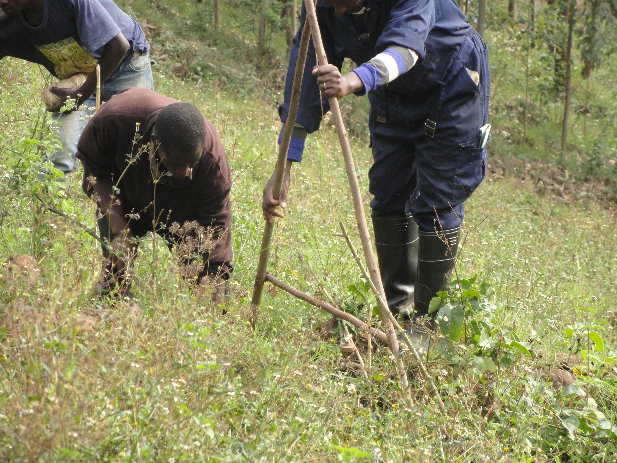
Areas which are prone to degradation by erosion are identified and later, the farmers are trained on benefits of this technology, how to set out the technology by use of the ‘A – frame’, how to construct the channels and how to maintain them by periodic de-silting and planting grasses and shrubs on the bands.
The 'A - Frame' is an A shaped structure made from wooden poles or thin metal poles that can be easily constructed and used to peg flat or graded contours or water drains.
This technology helps maintain the good top soil, which would have otherwise been washed down the slope into the valley and increases water retention.
The land users like this technology because their soil is not lost but what they dislike about this technology is that it is labour intensive, setting it out is technical and not easily conceptualized and it takes part of the land. Individual land users excavate these channels in their individual plots of land using simple hand tools like hoes, spades and pick axes.
2.3 រូបភាពនៃបច្ចេកទេស
វិចិត្រសាលប្រព័ន្ធផ្សព្វផ្សាយ
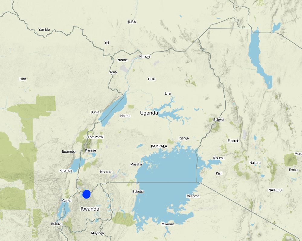
2.5 ប្រទេស/តំបន់/ទីតាំងកន្លែង ដែលបច្ចេកទេសត្រូវបានអនុវត្ត និងបានគ្រប់ដណ្តប់ដោយការវាយតម្លៃនេះ
ប្រទេស:
អ៊ូហ្គង់ដា
តំបន់/រដ្ឋ/ខេត្ត:
South Western Region
បញ្ជាក់បន្ថែមពីលក្ខណៈនៃទីតាំង:
Rubaya Sub County, Kabale District
បញ្ជាក់ពីការសាយភាយនៃបច្ចេកទេស:
- ត្រូវបានផ្សព្វផ្សាយត្រឹមតំបន់មួយ
មតិយោបល់:
rotational systems (crop rotation, fallows, shifting cultivation)
improved ground/ vegetation cover
integrated soil fertility management
Map
×2.6 កាលបរិច្ឆេទនៃការអនុវត្ត
បង្ហាញឆ្នាំនៃការចុះអនុវត្ត:
2015
2.7 ការណែនាំពីបច្ចេកទេស
សូមបញ្ជាក់តើបច្ចេកទេសត្រូវបានណែនាំឱ្យអនុវត្តដោយរបៀបណា:
- តាមរយៈគម្រោង / អន្តរាគមន៍ពីខាងក្រៅ
មតិយោបល់ (ប្រភេទនៃគម្រោង ។ល។):
The technology was introduced under the Integrated Water Resources Management Project to support farmers to mazimise land productivity
3. ចំណាត់ថ្នាក់នៃបច្ចេកទេស SLM
3.1 គោលបំណងចម្បង (១ ឬច្រើន) នៃបច្ចេកទេសនេះ
- ធ្វើឱ្យប្រសើរឡើងនូវផលិតកម្ម
- កាត់បន្ថយ, បង្ការ, ស្តារឡើងវិញនូវការធ្លាក់ចុះគុណភាពដី
- អភិរក្សប្រព័ន្ធអេកូឡូស៊ី
- ការពារតំបន់ទីជម្រាល/តំបន់ខ្សែទឹកខាងក្រោមបញ្ចូលជាមួយបច្ចេកទេសផ្សេងទៀត
- កាត់បន្ថយហានិភ័យនៃគ្រោះមហន្តរាយ
- បន្ស៊ាំទៅនឹងការប្រែប្រួលអាកាសធាតុ/គ្រោះមហន្តរាយ និងផលប៉ះពាល់របស់វា
- កាត់បន្ថយការប្រែប្រួលអាកាសធាតុ និងផលប៉ះពាល់របស់វា
- បង្កើតផលប្រយោជន៍សេដ្ឋកិច្ច
- បង្កើតផលប្រយោជន៍សង្គម
3.2 ប្រភេទដីប្រើប្រាស់មួយប្រភេទ (ច្រើនប្រភេទ) ដែលបានអនុវត្តបច្ចេកទេស

ដីដាំដំណាំ
- ដំណាំប្រចាំឆ្នាំ
- ដំណាំរយៈពេលវែង (មិនមែនឈើ)
ចំនួនសារដែលដាំដំណាំក្នុងមួយឆ្នាំ:
- 2
សូមបញ្ជាក់:
September to January and March to June
3.4 ការផ្គត់ផ្គង់ទឹក
ការផ្គត់ផ្គង់ទឹកនៅកន្លែងអនុវត្តបច្ចេកទេស:
- ទឹកភ្លៀង
3.5 ក្រុម SLM ដែលបច្ចេកទេសស្ថិតនៅក្នុង
- ប្រព័ន្ធដំណាំបង្វិល (ការដាំដំណាំវិលជុំ ការទុកដីចោលដើម្បីបង្កើនជីជាតិ កសិកម្មពនេចរ)
- ធ្វើឱ្យប្រសើរឡើងគម្របដី/ ដំណាំគម្របដី
- ការគ្រប់គ្រងជីជាតិដីតាមបែបចម្រុះ
3.6 វិធានការ SLM ដែលបញ្ចូលនូវបច្ចេកទេស

វិធានការរុក្ខជាតិ
- V1: ឈើធំៗ និងដើមឈើតូចៗ
- V2: ស្មៅនិងរុក្ខជាតិៗដែលដុះមានអាយុមិនលើសពី 2ឆ្នាំ

វិធានការរចនាស័ម្ពន្ធ
- S3: កម្ពស់ភ្លឺ ប្រឡាយ ផ្លូវទឹក
3.7 កំណត់ប្រភេទនៃការធ្លាក់ចុះគុណភាពដីសំខាន់ៗដែលបច្ចេកទេសនេះបានដោះស្រាយ

ការហូរច្រោះដីដោយសារទឹក
- Wt: ការបាត់ដីស្រទាប់លើដោយការហូរច្រោះ
- Wg: ការកកើតឡើងនូវកំទេចកំទីដីស្រទាប់ក្រោម
- Wm: ការបាក់ដី
3.8 ការពារ កាត់បន្ថយ ឬស្តារឡើងវិញនៃការធ្លាក់ចុះគុណភាពដី
បញ្ជាក់ពីគោលដៅរបស់បច្ចេកទេស ដែលផ្តោតទៅការធ្លាក់ចុះគុណភាពដី:
- ការកាត់បន្ថយការធ្លាក់ចុះគុណភាពដី
4. បច្ចេកទេសជាក់លាក់ សកម្មភាពអនុវត្ត ធាតុចូល និងថ្លៃដើម
4.1 គំនូសបច្ចេកទេសនៃបច្ចេកទេសនេះ
ឈ្មោះអ្នកនិពន្ធ:
Kigezi Diocese Water and Sanitation Programme
កាលបរិច្ឆេទ:
12/12/2016
ឈ្មោះអ្នកនិពន្ធ:
Kigezi Diocese Water and Sanitation Programme
កាលបរិច្ឆេទ:
12/12/2016
ឈ្មោះអ្នកនិពន្ធ:
Kigezi Diocese Water and Sanitation Programme
កាលបរិច្ឆេទ:
12/12/2016
4.2 ព័ត៌មានទូទៅដែលពាក់ព័ន្ធនឹងការគណនាធាតុចូល និងថ្លៃដើម
កំណត់របៀបនៃការគណនាថ្លៃដើម និងធាតុចូល:
- ក្នុងឯកតាបច្ចេកទេស
បញ្ជាក់ឯកតា:
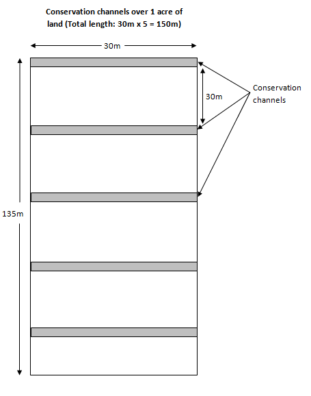
Per acre (each acre usually has 150meters of channels)
កំណត់រូបិយប័ណ្ណសម្រាប់ថ្លៃដើម:
- ដុល្លារ
បើពាក់ព័ន្ធសូមកំណត់អត្រាប្តូរប្រាក់ពីដុល្លាទៅរូបិយប័ណ្ណតំបន់ (ឧ. 1 ដុល្លារ = 79.9 រៀលនៃរូបិយប័ណ្ណប្រេស៊ីល) ៖ 1 ដុល្លារ =:
3300,0
កំណត់ថ្លៃឈ្នួលជាមធ្យមនៃការជួលកម្លាំងពលកម្មក្នុងមួយថ្ងៃ:
USD 2.12
4.3 សកម្មភាពបង្កើត
| សកម្មភាព | រយៈពេល (រដូវកាល) | |
|---|---|---|
| 1. | Setting out the soil and water conservation channel using the A-frame to set out the contour lines | After harvest of crops |
| 2. | Excavation of the soil and water conservation channel and build up soil bund on the lower side of the trench; leave a tie band every 10 meters | In the dry season |
| 3. | Planting of hedge rows on the bands | On the onset of rains |
4.4 ថ្លៃដើម និងធាតុចូលដែលត្រូវការសម្រាប់ការបង្កើតបច្ចេកទេស
| បញ្ជាក់ពីធាតុចូល | ឯកតា | បរិមាណ | ថ្លៃដើមក្នុងមួយឯកតា | ថ្លៃធាតុចូលសរុប | % នៃថ្លៃដើមដែលចំណាយដោយអ្នកប្រើប្រាស់ដី | |
|---|---|---|---|---|---|---|
| កម្លាំងពលកម្ម | Setting out | meter | 150,0 | 0,02 | 3,0 | 100,0 |
| កម្លាំងពលកម្ម | Excavation of the channels | meter | 150,0 | 1,06 | 159,0 | 100,0 |
| កម្លាំងពលកម្ម | Planting starria grass | meter | 150,0 | 0,02 | 3,0 | 100,0 |
| សម្ភារៈ | Forked hoes (1 piece can excavate 1km) | meter | 6,67 | 5,0 | 33,35 | |
| សម្ភារៈ | Pick axes (1 piece can excavate 1km) | meter | 6,67 | 5,0 | 33,35 | |
| សម្ភារៈ | Spades (1 piece can be used on 1km) | meter | 6,67 | 5,0 | 33,35 | |
| សម្ភារៈដាំដុះ | Starria grass (1 sack for 20m) | sacks | 7,5 | 7,0 | 52,5 | |
| ថ្លៃដើមសរុបក្នុងការបង្កើតបច្ចេកទេស | 317,55 | |||||
| ថ្លៃដើមសរុបក្នុងការបង្កើតបច្ចេកទេសគិតជាដុល្លារ | 0,1 | |||||
ប្រសិនបើអ្នកប្រើប្រាស់ដីមិនមានថ្លៃដើម 100% សូមបញ្ជាក់ថានរណាដែលចំណាយថ្លៃដើមដែលនៅសល់:
Kigezi Diocese Water and Sanitation Programme
មតិយោបល់:
The land users, after being trained, set out the soil and water conservation channels for themselves but the tools are beyond the financial capacity of the land user hence the need for subsidy
4.5 សកម្មភាពថែទាំ
| សកម្មភាព | ពេលវេលា/ ភាពញឹកញាប់ | |
|---|---|---|
| 1. | De-silting the channels and spreading the silt on the fields and restoring the bunds | When half full |
| 2. | Maintenance of the hedge rows by triming and replanting empty spaces | Continuous |
4.6 កំណត់ថ្លៃដើមសម្រាប់ការថែទាំ/ សកម្មភាពរបស់បច្ចេកទេស (ក្នុងរយៈពេលមួយឆ្នាំ)
| បញ្ជាក់ពីធាតុចូល | ឯកតា | បរិមាណ | ថ្លៃដើមក្នុងមួយឯកតា | ថ្លៃធាតុចូលសរុប | % នៃថ្លៃដើមដែលចំណាយដោយអ្នកប្រើប្រាស់ដី | |
|---|---|---|---|---|---|---|
| កម្លាំងពលកម្ម | Desilting of channels (when half full) | meter | 1,0 | 0,265 | 0,27 | 100,0 |
| កម្លាំងពលកម្ម | Trimming of hedge rows (100m per day) | days | 1,0 | 0,0212 | 0,02 | 100,0 |
| ថ្លៃដើមសរុបសម្រាប់ការថែទាំដំណាំតាមបច្ចេកទេស | 0,29 | |||||
មតិយោបល់:
The initial investment of the equipment is adequate for maintenance at least for some years
4.7 កត្តាសំខាន់បំផុតដែលមានឥទ្ធិពលដល់ការចំណាយ
ពណ៌នាពីកត្តាប៉ះពាល់ចម្បងៗទៅលើថ្លៃដើម:
The costs have been calculated basing on depth of top soil of 51 – 80cm. When the depth of the top soil is shallow, then the costs of breaking the underlying sub-surface layers, which are usually rock, are much higher. Also during the rainy season, the soil is more workable
The costs of maintenance will be less where the rest of the landscape also has conservation channels, has good vegetative cover and where the hill slope is gentle.
5. លក្ខណៈបរិស្ថានធម្មជាតិ និងមនុស្ស
5.1 អាកាសធាតុ
បរិមាណទឹកភ្លៀងប្រចាំឆ្នាំ
- < 250 មម
- 251-500 មម
- 501-750 មម
- 751-1,000 មម
- 1,001-1,500 មម
- 1,501-2,000 មម
- 2,001-3,000 មម
- 3,001-4,000 មម
- > 4,000 មម
លក្ខណៈពិសេស/ មតិយោបល់លើរដូវភ្លៀង:
Bi-modal rainfall pattern with long rainy season from September to December then March to May
បញ្ជាក់ឈ្មោះឯកសារយោងនៃស្ថានីយឧតុនិយម:
Kabale District Meterological Department
តំបន់កសិអាកាសធាតុ
- មានភ្លៀងមធ្យម
5.2 សណ្ឋានដី
ជម្រាលជាមធ្យម:
- រាបស្មើ (0-2%)
- ជម្រាលតិចតួច (3-5%)
- មធ្យម (6-10%)
- ជម្រាលខ្ពស់បន្តិច (11-15%)
- ទីទួល (16-30%)
- ទីទួលចោត (31-60%)
- ទីទួលចោតខ្លាំង (>60%)
ទម្រង់ដី:
- ខ្ពង់រាប
- កំពូលភ្នំ
- ជម្រាលភ្នំ
- ជម្រាលទួល
- ជម្រាលជើងភ្នំ
- បាតជ្រលងភ្នំ
តំបន់តាមរយៈកម្ពស់ :
- 0-100 ម
- 101-500 ម
- 501-1,000 ម
- 1,001-1,500 ម
- 1,501-2,000 ម
- 2,001-2,500 ម
- 2,501-3,000 ម
- 3,001-4,000 ម
- > 4,000 ម
បញ្ជាក់ថាតើបច្ចេកទេសនេះត្រូវបានអនុវត្តន៍នៅក្នុង:
- មិនពាក់ព័ន្ធទាំងអស់
5.3 ដី
ជម្រៅដីជាមធ្យម:
- រាក់ខ្លាំង (0-20 សម)
- រាក់ (21-50 សម)
- មធ្យម (51-80 សម)
- ជ្រៅ (81-120 សម)
- ជ្រៅខ្លាំង (> 120 សម)
វាយនភាពដី (ស្រទាប់លើ):
- មធ្យម (ល្បាយ, ល្បាប់)
វាយនភាពដី (> 20 សម ស្រទាប់ក្នុង):
- មធ្យម (ល្បាយ, ល្បាប់)
សារធាតុសរីរាង្គនៅស្រទាប់ដីខាងលើ:
- មធ្យម (1-3%)
5.4 ទឹកដែលអាចទាញមកប្រើប្រាស់បាន និងគុណភាពទឹក
នីវ៉ូទឹកក្រោមដី:
> 50 ម
ទឹកលើដីដែលអាចទាញយកប្រើប្រាស់បាន:
ល្អ
គុណភាពទឹក (មិនបានធ្វើប្រត្តិកម្ម):
ទឹកពិសារដែលគ្មានគុណភាព (តម្រូវឱ្យមានការសំអាត)
តើមានបញ្ហាភាពទឹកប្រៃហូរចូលមកដែរឬទេ?
ទេ
តើទឹកជំនន់កំពុងកើតមាននៅតំបន់នេះដែររឺទេ?
បាទ/ចា៎
ភាពទៀងទាត់:
ម្តងម្កាល
មតិយោបល់ និងលក្ខណៈពិសេសផ្សេងៗទៀតលើគុណភាព និងបរិមាណទឹក :
Water quantity and quality is dependent on human activities and rainfall patterns
5.5 ជីវៈចម្រុះ
ភាពសម្បូរបែបនៃប្រភេទ:
- កម្រិតមធ្យម
ភាពសម្បូរបែបនៃទីជម្រក:
- កម្រិតមធ្យម
5.6 លក្ខណៈនៃអ្នកប្រើប្រាស់ដីដែលអនុវត្តបច្ចេកទេស
នៅមួយកន្លែង ឬពនេចរ :
- នៅមួយកន្លែង
ទីផ្សារនៃប្រព័ន្ធផលិតកម្ម:
- សម្រាប់ហូបក្នុងគ្រួសារ (ផ្គត់ផ្គង់ខ្លួនឯង)
- ពាក់កណ្តាលពាណិជ្ជកម្ម (ផ្គត់ផ្គង់ខ្លួនឯង/ ពាណិជ្ជកម្ម)
ចំណូលក្រៅកសិកម្ម:
- តិចជាង 10% នៃចំណូល
កម្រិតជីវភាព:
- មិនល្អ
ឯកជន ឬក្រុម:
- ធ្វើខ្លួនឯង/ គ្រួសារ
កម្រិតប្រើប្រាស់គ្រឿងយន្ត:
- ប្រើកម្លាំងពលកម្ម
យេនឌ័រ:
- ស្ត្រី
- បុរស
អាយុរបស់អ្នកប្រើប្រាស់ដី:
- យុវវ័យ
- វ័យកណ្តាល
5.7 ទំហំផ្ទៃដីជាមធ្យមនៃដីប្រើប្រាស់ដោយអ្នកប្រើប្រាស់ដី ក្នុងការអនុវត្តបច្ចេកទេស
- < 0.5 ហិកតា
- 0.5-1 ហិកតា
- 1-2 ហិកតា
- 2-5 ហិកតា
- 5-15 ហិកតា
- 15-50 ហិកតា
- 50-100 ហិកតា
- 100-500 ហិកតា
- 500-1,000 ហិកតា
- 1,000-10,000 ហិកតា
- > 10,000 ហិកតា
5.8 ភាពជាម្ចាស់ដី កម្មសិទ្ធប្រើប្រាស់ដី និងកម្មសិទ្ធប្រើប្រាស់ទឹក
ភាពជាម្ចាស់ដី:
- ឯកជន មិនមានកម្មសិទ្ធ
កម្មសិទ្ធិប្រើប្រាស់ដី:
- ឯកជន
កម្មសិទ្ធប្រើប្រាស់ទឹក:
- ជាក្រុម (មានដែនកំណត់)
5.9 ការប្រើប្រាស់សេវាកម្ម និងហេដ្ឋារចនាសម្ព័ន្ធ
សុខភាព:
- មិនល្អ
- មធ្យម
- ល្អ
ការអប់រំ:
- មិនល្អ
- មធ្យម
- ល្អ
ជំនួយបច្ចេកទេស:
- មិនល្អ
- មធ្យម
- ល្អ
ការងារ (ឧ. ការងារក្រៅកសិដ្ឋាន):
- មិនល្អ
- មធ្យម
- ល្អ
ទីផ្សារ:
- មិនល្អ
- មធ្យម
- ល្អ
ថាមពល:
- មិនល្អ
- មធ្យម
- ល្អ
ផ្លូវ និងការដឹកជញ្ជូន:
- មិនល្អ
- មធ្យម
- ល្អ
ទឹកផឹក និងអនាម័យ:
- មិនល្អ
- មធ្យម
- ល្អ
សេវាកម្មហិរញ្ញវត្ថុ:
- មិនល្អ
- មធ្យម
- ល្អ
6. ផលប៉ះពាល់ និងការសន្និដ្ឋាន
6.1 ផលប៉ះពាល់ក្នុងបរិវេណអនុវត្តបច្ចេកទេសដែលកើតមាន
ផលប៉ះពាល់លើសេដ្ឋកិច្ចសង្គម
ផលិតផល
ផលិតកម្មដំណាំ
មតិយោបល់/ ការបញ្ជាក់:
The impacts are seen immediately after the first crop
គុណភាពដំណាំ
ផលិតកម្មចំណីសត្វ
គុណភាពចំណីសត្វ
ហានិភ័យនៃភាពបរាជ័យរបស់ផលិតកម្ម
ផ្ទៃដីផលិតកម្ម
ការគ្រប់គ្រងដី
ចំណូល និងថ្លៃដើម
ការចំណាយលើធាតុចូលកសិកម្ម
ចំណូលក្នុងកសិដ្ឋាន
ភាពសម្បូរបែបប្រភពប្រាក់ចំណូល
បន្ទុកការងារ
ផលប៉ះពាល់ទៅលើវប្បធម៌សង្គម
សន្តិសុខស្បៀង/ ភាពគ្រប់គ្រាន់ខ្លួនឯង
ស្ថានភាពសុខភាព
ស្ថាប័នសហគមន៍
ចំណេះដឹង SLM / ការធ្លាក់ចុះគុណភាពដី
ការកាត់បន្ថយជម្លោះ
ផលប៉ះពាល់ទៅលើអេកូឡូស៊ី
វដ្តទឹក/លំហូរ
លំហូរទឹកលើផ្ទៃដី
នីវ៉ូទឹកក្រោមដី/ ដង្ហើមទឹក
ដី
សំណើមដី
គម្របដី
ការបាត់បង់ដី
ការកើនឡើងដី
សារធាតុសរីរាង្គដី/ការបូនក្រោមដី
ការកាត់បន្ថយហានិភ័យនៃគ្រោះមហន្តរាយ និងគ្រោះអាកាសធាតុ
ផលប៉ះពាល់នៃទឹកជំនន់
6.2 ផលប៉ះពាល់ក្រៅបរិវេណអនុវត្តបច្ចេកទេសដែលកើតមាន
ទឹកដែលអាចទាញមកប្រើប្រាស់បាន
ទឹកជំនន់ខ្សែទឹកខាងក្រោម
ខូចខាតដល់ស្រែអ្នកជិតខាង
ខូចខាតដល់ហេដ្ឋារចនាសម្ព័ន្ធសាធារណៈ/ឯកជន
6.3 ភាពប្រឈម និងភាពរួសនៃបច្ចេកទេសទៅនឹងការប្រែប្រួលអាកាសធាតុ និងគ្រោះអាកាសធាតុ/ គ្រោះមហន្តរាយ (ដែលដឹងដោយអ្នកប្រើប្រាស់ដី)
ការប្រែប្រួលអាកាសធាតុ
ការប្រែប្រួលអាកាសធាតុ
| រដូវកាល | កើនឡើង ឬថយចុះ | លក្ខណៈឆ្លើយតបនៃបច្ចេកទេសទៅនឹងការប្រែប្រួលអាកាសធាតុ | |
|---|---|---|---|
| សីតុណ្ហភាពប្រចាំឆ្នាំ | កើនឡើង | មិនស្គាល់ | |
| សីតុណ្ហភាពប្រចាំរដូវកាល | សើម/រដូវភ្លៀង | កើនឡើង | មិនស្គាល់ |
| សីតុណ្ហភាពប្រចាំរដូវកាល | រដូវប្រាំង | កើនឡើង | មិនស្គាល់ |
| បរិមាណទឹកភ្លៀងប្រចាំឆ្នាំ | ថយចុះ | ល្អ | |
| បរិមាណទឹកភ្លៀងប្រចាំរដូវកាល | សើម/រដូវភ្លៀង | ថយចុះ | ល្អ |
គ្រោះអាកាសធាតុ (មហន្តរាយ)
គ្រោះមហន្តរាយធម្មជាតិ
| លក្ខណៈឆ្លើយតបនៃបច្ចេកទេសទៅនឹងការប្រែប្រួលអាកាសធាតុ | |
|---|---|
| ព្យុះភ្លៀងតាមតំបន់ | ល្អ |
| ព្យុះរន្ទះតាមតំបន់ | ល្អ |
| ព្យុះទឹកកកតាមតំបន់ | ល្អ |
គ្រោះមហន្តរាយអាកាសធាតុ
| លក្ខណៈឆ្លើយតបនៃបច្ចេកទេសទៅនឹងការប្រែប្រួលអាកាសធាតុ | |
|---|---|
| ភ្លើងឆេះ | ល្អ |
គ្រោះមហន្តរាយទឹក
| លក្ខណៈឆ្លើយតបនៃបច្ចេកទេសទៅនឹងការប្រែប្រួលអាកាសធាតុ | |
|---|---|
| ទឹកជំនន់ទូទៅ (ទន្លេ) | ល្អណាស់ |
| ទឹកជំនន់ដោយទឹកភ្លៀង | ល្អណាស់ |
| ដីបាក់ | ល្អ |
គ្រោះមហន្តរាយជីវៈសាស្ត្រ
| លក្ខណៈឆ្លើយតបនៃបច្ចេកទេសទៅនឹងការប្រែប្រួលអាកាសធាតុ | |
|---|---|
| ការរាតត្បាតនៃជំងឺ | មធ្យម |
| ការមានបញ្ហាសត្វល្អិត/ដង្កូវ | មិនស្គាល់ |
6.4 ការវិភាគថ្លៃដើម និងអត្ថប្រយោជន៍
តើផលចំណេញ និងថ្លៃដើមត្រូវបានប្រៀបធៀបគ្នាយ៉ាងដូចម្តេច (ទស្សនៈរបស់អ្នកប្រើប្រាស់ដី)?
រយៈពេលខ្លី:
វិជ្ជមាន
រយៈពេលវែង:
វិជ្ជមានខ្លាំង
តើផលចំណេញ និងការថែទាំ/ ជួសជុលត្រូវបានប្រៀបធៀបគ្នាយ៉ាងដូចម្តេច (ទស្សនៈរបស់អ្នកប្រើប្រាស់ដី)?
រយៈពេលខ្លី:
វិជ្ជមាន
រយៈពេលវែង:
វិជ្ជមានខ្លាំង
មតិយោបល់:
The adoption rate of this technology is gradual as people keep appreciating the benefits
6.5 ការទទួលយកបច្ចេកទេស
- 1-10%
ក្នុងចំណោមគ្រួសារទាំងអស់ដែលបានអនុវត្តបច្ចេកទេស តើមានប៉ុន្មានគ្រួសារដែលចង់ធ្វើដោយខ្លួនឯង ដោយមិនទទួលបានសម្ភារៈលើកទឹកចិត្ត/ប្រាក់ឧបត្ថម្ភ?:
- 0-10%
6.6 ការបន្សុំា
តើថ្មីៗនេះ បច្ចេកទេសនេះត្រូវបានកែតម្រូវដើម្បីបន្ស៊ាំទៅនឹងស្ថានភាពប្រែប្រួលដែរឬទេ?
ទេ
6.7 ភាពខ្លាំង/ គុណសម្បត្តិ/ ឱកាសនៃបច្ចេកទេស
| ភាពខ្លាំង/ គុណសម្បត្តិ/ ឱកាសនៅកន្លែងរបស់អ្នកប្រើប្រាស់ដី |
|---|
| 1) It controls soil loss from the land users garden |
| 2) It provides silt which is spread in their garden |
| 3) Hedge rows are used as fodder and as mulching material |
| 4) The conserved water is used to benefit the plants in the same garden |
| ភាពខ្លាំង/ គុណសម្បត្តិ/ ឱកាស ទស្សនៈរបស់បុគ្គលសំខាន់ៗ |
|---|
| 1) It improves water percolation in the soil which increases soil moisture content and increases ground water recharge |
| 2) It is a simple technology which uses simple hand tools |
| 3) It reduces conflicts related to land being washed into the neighbours plot since land is fragmented |
6.8 ភាពខ្សោយ/ គុណវិបត្តិ/ ហានិភ័យនៃបច្ចេកទេស និងវិធីសាស្ត្រដោះស្រាយ
| ភាពខ្សោយ/ គុណវិបត្តិ/ ហានិភ័យ ទស្សនៈរបស់អ្នកប្រើប្រាស់ដី | តើបច្ចេកទេសទាំងនោះបានដោះស្រាយបញ្ហាដូចម្តេច? |
|---|---|
| 1) This technology requires a lot of hard labour | The land users were encouraged to form small groups which work together to ease the work and share knowledge and skill |
| 2) Land users feel that the channels take up alot of their land, which would otherwise be used for growing crops | The land users have been helped to appreciate the benefits of the technology in making the seemingly smaller land more productive |
| ភាពខ្សោយ/ គុណវិបត្តិ/ ហានិភ័យ ទស្សនៈរបស់អ្នកចងក្រងឬបុគ្គលសំខាន់ៗ | តើបច្ចេកទេសទាំងនោះបានដោះស្រាយបញ្ហាដូចម្តេច? |
|---|---|
| 1) This technology is dependent on land users continued efforts in de-silting and maintenance of the hedge rows. When this is not done the technology fails | Land users are encouraged to periodically desilt the channels |
| 2) The effectiveness of this technology is dependent on the compliance of other land users in the landscape. For example if it is done downhill and not uphill, then the channels will be overwhelmed by the volume of the soil and water runoff | All community members were sensitised on the importance and effectiveness of this technology and existing by-laws will foster members uphill to practice the technology. The benefits of the technology will encourage other land users to adopt it |
| 3) The process of maintaining and rolling out this technology requires engagement of many stakeholders | Management structures, which are well linked with government structures, have been set up and trained at various levels to manage the process of maintaining and rolling out the technology |
7. ឯកសារយោង និងវេបសាយ
7.1 វិធីសាស្ត្រ/ ប្រភពនៃព័ត៌មាន
- តាមការចុះទីវាល ការស្រាវជ្រាវនៅទីវាល
Observation field visits to the different land users
- ការសម្ភាសន៍ជាមួយអ្នកប្រើប្រាស់ដី
Focus group discussion with 18 land users
- ការសម្ភាសន៍ជាមួយអ្នកជំនាញ/ ឯកទេស
Interviews with programme (KDWSP) staff
- ការចងក្រងពីរបាកការណ៍ និងឯកសារផ្សេងៗទៀតដែលមាន
Information gathered from programme progress reports and Ministry of Water and Environment Documentation
តើពេលណាដែលទិន្នន័យបានចងក្រង (នៅទីវាល)?
07/09/2016
7.2 ឯកសារយោងដែលបានចេញផ្សាយ
ចំណងជើង អ្នកនិពន្ធ ឆ្នាំ ISBN:
Kigezi Diocese Water and Sanitation Programme, IWRM Annual Report (April 2015 - March 2016)
មានប្រភពមកពីណា? ថ្លៃដើមប៉ុន្មាន?
www.kigezi-watsan.ug
ចំណងជើង អ្នកនិពន្ធ ឆ្នាំ ISBN:
IWRM Pilot report 2013
មានប្រភពមកពីណា? ថ្លៃដើមប៉ុន្មាន?
www.kigezi-watsan.ug
7.3 ការភ្ជាប់ទៅកាន់ព័ត៌មានពាក់ព័ន្ធលើប្រព័ន្ធអនឡាញ
ចំណងជើង/ ពណ៌នា:
Handbook of chennel design for soil and water conservation
វេបសាយ:
www.worldwidehelpers.org
ចំណងជើង/ ពណ៌នា:
Soil conservation handbook
វេបសាយ:
www.wcc.nrcs.usda.gov/ftpref/wntsc/H&H/TRsTPs/TP61.pdf
ចំណងជើង/ ពណ៌នា:
Soil conservation
វេបសាយ:
http://www.fao.org/docrep/t0321e/t0321e-10.htm
ការតភ្ជាប់ និងម៉ូឌុល
ពង្រីកមើលទាំងអស់ បង្រួមទាំងអស់ការតភ្ជាប់
Catchment Based Integrated Water Resources Management [អ៊ូហ្គង់ដា]
Catchment based integrated water resources management is a process which promotes the coordinated development and management of water, land and related resources in order to maximise economic and social welfare in an equitable manner without compromising the sustainability of vital eco systems
- អ្នកចងក្រង៖ Philip Tibenderana
ម៉ូឌុល
គ្មានម៉ូឌុល