From storylines to scenarios: raising awareness and decision support
(ບາຊິວ)
ຄຳອະທິບາຍ
Investigating viable carbon-optimized land management strategies, which maintain or improve ecosystem function, under changing climate conditions in the Southern Amazon - using regional scenarios generated from storylines.
Aims / objectives: One objective of the Carbiocial project, in close cooperation with its Brazilian partner project Carbioma, is to explore how land use change in one of Brazil’s most dynamic regions will develop in the next 30 years and how it will be affected by the implementation of land-use planning options and conservation policies. For this purpose a set of scenarios was created. The scenarios portray different plausible development pathways for the region. Each scenario consists of a storyline: a brief narrative of the future. At this level farmers and institutions are involved. An expert panel translated the findings of several stakeholder workshops and extensive stakeholder and expert interviews, conducted in 2012, into qualitative information needed to elaborate these scenarios. Four storylines emerged: (1) “business-as-usual”; (2) sustainable, extensive use of the Amazon; (3) legal intensification; (3) illegal intensification.
Methods: It was agreed that the communication between qualitative social science data and quantitative data had to be considered carefully. A blend of the required input factors for the models was agreed as guiding principles for all storylines: these were: population, agrarian production, livestock, agrarian and environmental policies, protected areas, infrastructure, impact of climate change (mitigation/adaptation). In a second step, qualitative data had to be added to the models; to limit bias, all available German experts on Southern Amazonia participated in a day-long (and quite controversial) brainstorming session producing content for the four storylines.
After translating the results into Portuguese the outcome was discussed with representatives of government and NGOs to discuss their plausibility and to modify accordingly. The input of local stakeholders was included on the basis of discussions and qualitative interviews. Generally speaking, the feedback loops with Brazilian stakeholders’ happened rather arbitrarily. Participation could have been better if planned more methodically and earlier.
The three hypothetical storylines describe different pathways of future regional development within the two states. Due to the strong linkages of Southern Amazonia to global markets (e.g. exports of soybean and meat) it was necessary to portray this dependency as one important determinant within the scenarios. Also, law enforcement of the existing legal situation was considered: more than 40% of Amazônia comprises protected areas. In order to portray the possibility of progressive environmental and indigenous legislation, a vibrant civil society, and well-institutionalized public prosecutors, a sustainability scenario was designed.
The next step was the quantification of the qualitative information to facilitate a simulation-based scenario analysis. Simulation models will be combined as software packages to support the decision-taking process from local to landscape and regional scale. All research and implementation activities include direct involvement of the stakeholders. Field experiments for improving C storage and ecosystem function will be performed in cooperation with an NGO founded by the farmers of Mato Grosso.
Other important information: A set of land use maps was generated to depict scenarios from 2010 to 2030. The objective of this modelling and mapping exercise is to support decision-makers to better interpret the scenarios and their implications. These new layers of information will facilitate further model or GIS-based analysis of land use change impacts on the regional carbon balance and the loss of biodiversity, and may act as a test-bed for the development of strategies towards sustainable land management.
ສະຖານທີ່
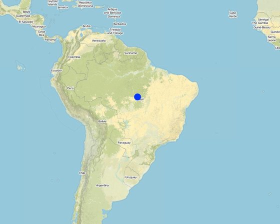
ສະຖານທີ່: Mato Grosso/Pará, Brazil, ບາຊິວ
ການຄັດເລືອກພື້ນທີ່ ທີ່ອີງໃສ່ຂໍ້ມູນທາງພູມີສາດ
ວັນທີເລີ່ມຕົ້ນ: 2011
ປີຂອງການສິ້ນສຸດ: 2016
ປະເພດຂອງແນວທາງ
-
ພື້ນເມືອງ / ທ້ອງຖີ່ນ
-
ການລິເລີ່ມ ພາຍໃນປະເທດ ທີ່ຜ່ານມາ / ນະວັດຕະກໍາ
-
ພາຍໃຕ້ໂຄງການ / ແຜນງານ
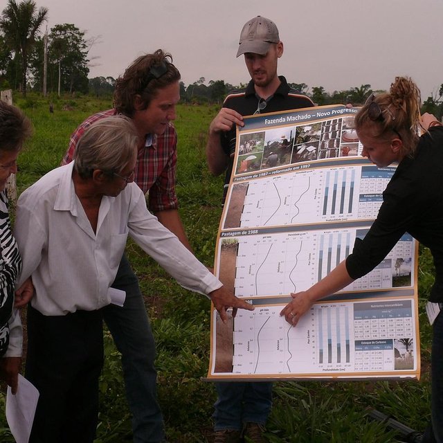
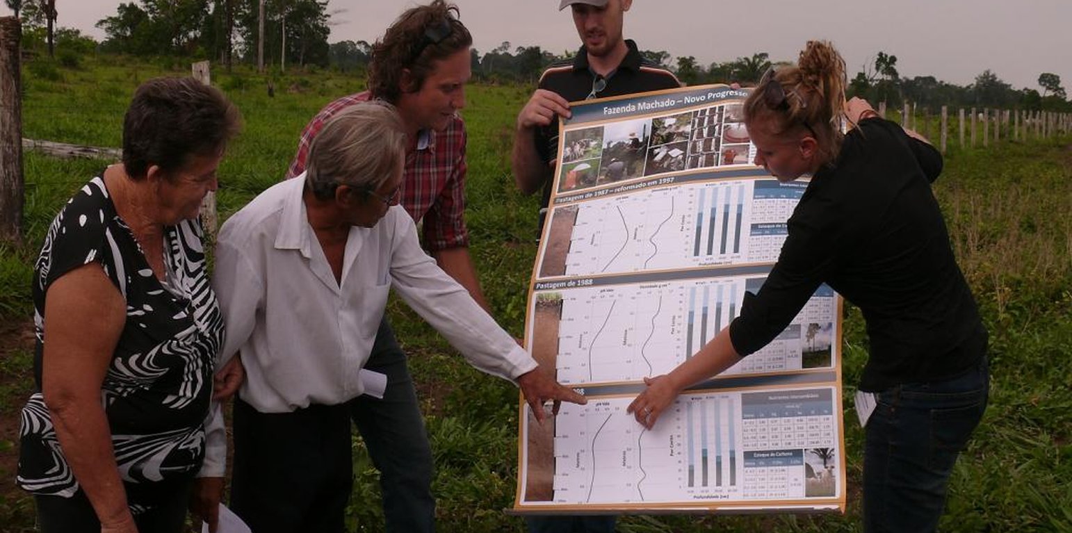
Discussing results with land users to raise awareness (Stefan Hohnwald)
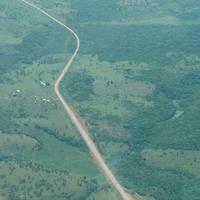
Land use system along Route BR 163 (Stefan Hohnwald)
ເປົ້າໝາຍຂອງແນວທາງ ແລະ ການປົກປັກຮັກສາສິ່ງແວດລ້ອມ
ເປົ້າໝາຍ / ຈຸດປະສົງຫຼັກໃນການຈັດຕັ້ງປະຕິບັດແນວທາງ
The Approach focused mainly on other activities than SLM (carbon-optimized land management)
The joint main goals are 1) to perform region-specific analyses in order to improve and apply interdisciplinary sets of models of land use impacts on carbon stocks, water and GHG balances, 2) to develop and optimize land management strategies that minimize carbon losses and GHG emissions, and maximize carbon sequestration, 3) to assess the trade-offs between land management options and socio-economic impacts in terms of GHG reduction, profitability, ecological sustainability, and last but not least, 4) to support the Brazilian partners to implement the optimal techniques in practice, considering the soybean value chain and overall carbon balance.
The SLM Approach addressed the following problems: High loss of vegetative and soil carbon due to agricultural expansion (deforestation), agricultural emissions, biodiversity loss.
ເງື່ອນໄຂທີ່ສະໜັບສະໜູນໃຫ້ການຈັດຕັ້ງປະຕິບັດເຕັກໂນໂລຢີ ບົນພື້ນຖານແນວທາງ
ເງື່ອນໄຂທີ່ເຊື່ອງຊ້ອນໃຫ້ການຈັດຕັ້ງປະຕິບັດເຕັກໂນໂລຢີ ບົນພື້ນຖານແນວທາງ
-
ສັງຄົມ / ວັດທະນະທໍາ / ມາດຕະຖານ ແລະ ຄຸນຄ່າທາງສາສະໜາ: Acceptance of research results
Treatment through the SLM Approach: Dissemination of research results in the form of policy briefs (short graphical illustration of results) and “output-stick” (USB stick with more detailed research results).
-
ກ່ຽວກັບກົດໝາຍ (ສິດນໍາໃຊ້ດິນ, ສິດນໍາໃຊ້ນໍ້າ): Land tenure
Treatment through the SLM Approach: None
The existing land ownership, land use rights / water rights greatly hindered the approach implementation Especially in Pará, land tenure rights are uncertain and lead to land speculation with resultant land degradation and deforestation.
ການມີສ່ວນຮ່ວມ ແລະ ບົດບາດຂອງພາກສ່ວນທີ່ກ່ຽວຂ້ອງທີ່ມີສ່ວນຮ່ວມ
ພາລະບົດບາດຂອງພາກສ່ວນທີ່ກ່ຽວຂ້ອງ ທີ່ມີສ່ວນຮ່ວມໃນການຈັດຕັ້ງປະຕິບັດແນວທາງ
| ແມ່ນໃຜ / ພາກສ່ວນໃດ ທີ່ເປັນເຈົ້າການ ໃນການຈັດຕັ້ງປະຕິບັດ ວິທີການ? |
ລະບຸ ພາກສ່ວນທີ່ກ່ຽວຂ້ອງ |
ພັນລະນາ ບົດບາດ ໜ້າທີ່ ຂອງພາກສ່ວນທີ່ກ່ຽວຂ້ອງ |
| ຜູ້ນໍາໃຊ້ດິນໃນທ້ອງຖິ່ນ / ຊຸມຊົນທ້ອງຖິ່ນ |
|
|
| ອົງການຈັດຕັ້ງ ພາຍໃນຊຸມຊົນ |
Indigenous groups were involved in stakeholder workshops with the aim of discussing different storyline options, and in the following feedback loops discussing the resulting storylines. |
|
| ຜູ້ຊ່ຽວຊານ ການນຄຸ້ມຄອງ ທີ່ດິນແບບຍືນຍົງ / ທີ່ປຶກສາດ້ານກະສິກໍາ |
|
|
| ພະນັກງານຂັ້ນສູນກາງ (ຜູ້ວາງແຜນ, ຜູ້ສ້າງນະໂຍບາຍ) |
planning authorities |
|
ການລວບລວມເອົາຜູ້ນໍາໃຊ້ທີ່ດິນໃນທ້ອງຖິ່ນ/ຊຸມຊົນທ້ອງຖິ່ນ ໃນການຈັດຕັ້ງປະຕິບັດແນວທາງ ແຕ່ລະໄລຍະ
ບໍ່ມີ
ການບໍ່ປະຕິບັດ
ການຊ່ວຍເຫຼືອຈາກພາຍນອກ
ການຮ່ວມມື
ການນໍາໃໍຊ້ເອງ
ການເລີ່ມຕົ້ນ / ແຮງຈູງໃຈ
Land users and planning authorities; identification of research priorities, state-of-the-art of agricultural practices, identification of problems.
ຕິດຕາມກວດກາ / ການປະເມີນຜົນ
Research
Research plots for demonstration.
ແຜ່ນວາດສະແດງ
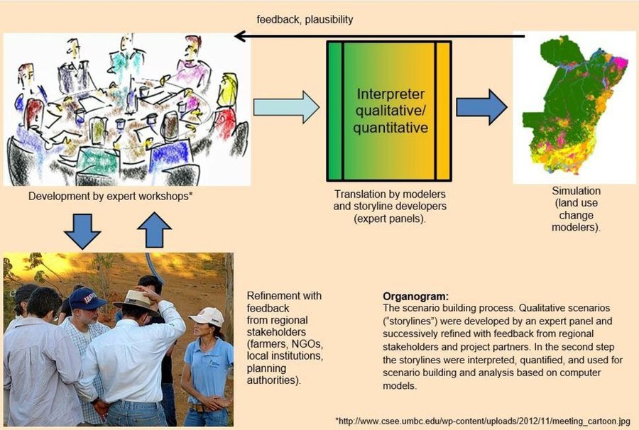
The scenario building process. Qualitative scenarios (“storylines”) were developed by an expert panel and successively refined with feedback from regional stakeholders and project partners. In the second step the storylines were interpreted, quantified, and used for scenario building and analysis based on computer models.
ການຕັດສິນໃຈໃນການເລືອກເຕັກໂນໂລຢີ ການຄຸ້ມຄອງທີ່ດິນແບບຍືນຍົງ
ການຕັດສິນໃຈໂດຍ
-
ຜູ້ນໍາໃຊ້ດິນຜູ້ດຽວ (ການລິເລີ່ມດ້ວຍຕົນເອງ)
-
ຜູ້ນໍາໃຊ້ທີ່ດິນຫຼັກ, ການສະໜັບສະໜູນ ໂດຍຜູ້ຊ່ຽວຊານ ການນໍາໃຊ້ທີ່ດິນແບບຍືນຍົງ
-
ພາກສ່ວນກ່ຽວຂ້ອງທັງໝົດ, ເປັນສ່ວນໜຶ່ງ ຂອງວິທີທາງແບບມີສ່ວນຮ່ວມ
-
ຜູ້ຊ່ຽວຊານ ຫຼັກດ້ານການຄຸ້ມຄອງ ທີ່ດິນແບບຍືນຍົງ, ມີການຕິດຕາມປຶກສາຫາລືກັບຜູ້ນໍາໃຊ້ທີ່ດິນ
-
ຊຽ່ວຊານ ສະເພາະດ້ານການຄຸ້ມຄອງ ດິນແບບຍືນຍົງຜູ້ດຽວ
-
ນັກການເມືອງ / ຜູ້ນໍາ
ການຕັດສິນໃຈບົນພື້ນຖານ
-
ປະເມີນເອກກະສານ ຄວາມຮູ້ກ່ຽວກັບ ການຄຸ້ມຄອງ ທີ່ດິນແບບຍືນຍົງ (ຫຼັກຖານທີ່ຊ່ວຍໃນການຕັດສິນໃຈ)
-
ຜົນທີ່ໄດ້ຮັບ ຈາກການຄົ້ນຄວ້າ
-
ປະສົບການສ່ວນບຸກຄົນ ແລະ ຄວາມຄິດເຫັນ (ທີ່ບໍ່ເປັນເອກກະສານ)
ການສະໜັບສະໜູນເຕັກໂນໂລຢີ, ການສ້າງຄວາມອາດສາມາດ ແລະ ການຄຸ້ມຄອງຄວາມຮູ້
ກິດຈະກຳ ດັ່ງລຸ່ມນີ້ ແມ່ນເປັນພາກໜຶ່ງຂອງແນວທາງ
-
ການສ້າງຄວາມສາມາດ / ການຝຶກອົບຮົມ
-
ການບໍລິການໃຫ້ຄໍາປຶກສາ
-
ສະຖາບັນການສ້າງຄວາມເຂັ້ມແຂງ (ການພັດທະນາອົງການຈັດຕັ້ງ)
-
ຕິດຕາມກວດກາ ແລະ ປະເມີນຜົນ
-
ການຄົ້ນຄວ້າ
ການສ້າງຄວາມອາດສາມາດ / ຝຶກອົບຮົມ
ໄດ້ສະໜັບສະໜູນຝຶກອົບຮົມໃຫ້ແກ່ພາກສ່ວນກ່ຽວຂ້ອງດັ່ງລຸ່ມນີ້
-
ຜູ້ນໍາໃຊ້ດິນ
-
ພະນັກງານພາກສະໜາມ / ທີ່ປຶກສາ
ຮູບແບບການຝຶກອົບຮົມ
-
ການເຮັດຕົວຈິງ
-
ຕົວຕໍ່ຕົວ
-
ເນື້ອທີ່ສວນທົດລອງ
-
ກອງປະຊຸມ
-
ຫຼັກສູດ
ກວມເອົາຫົວຂໍ້
Training focused on raising awareness of the consequences of “business-as-usual” behavior compared with other scenarios.
ການບໍລິການທາງດ້ານການໃຫ້ຄໍາປຶກສາ
ໄດ້ຮັບການບໍລິການທາງດ້ານການໃຫ້ຄໍາປຶກສາ
-
ໃນພື້ນທີ່ຂອງຜູ້ນໍາໃຊ້ດິນ
-
ສູນຄົ້ນຄວ້າ
Name of method used for advisory service: dissemination of research results in the form of policy briefs and more detailed “output sticks”
Advisory service is quite adequate to ensure the continuation of land conservation activities
ການຕິດຕາມ ແລະ ປະເມີນຜົນ
bio-physical aspects were ad hoc monitored by project staff through observations
bio-physical aspects were ad hoc monitored by project staff through measurements
socio-cultural aspects were ad hoc monitored by project staff through observations
socio-cultural aspects were ad hoc monitored by project staff through measurements
There were few changes in the Approach as a result of monitoring and evaluation: Dissemination; form of dissemination was adjusted according to the requirements of target groups.
There were no changes in the Technology as a result of monitoring and evaluation
ການຄົ້ນຄວ້າ
ການວິໄຈໄດ້ຮັບການຮັກສາຫົວຂໍ້ຕໍ່ໄປນີ້
-
ສັງຄົມ
-
ເສດຖະສາດ / ການຕະຫຼາດ
-
ລະບົບນິເວດ
-
ເຕັກໂນໂລຢີ
Research was carried out both on station and on-farm
ການສະໜັບສະໜູນທາງດ້ານການເງິນ ແລະ ອຸປະກອນຈາກພາຍນອກ
ງົບປະມານປະຈຳປີ ໃນກິດຈະກຳ ການຄຸ້ມຄອງທີ່ດິນແບບຍືນຍົງ ທີ່ເປັນສະກຸນເງິນໂດລາ
-
< 2,000
-
2,000-10,000
-
10,000-100,000
-
100,000-1,000,000
-
> 1,000,000
Precise annual budget: n.a.
Approach costs were met by the following donors: international (German Ministry of Education and Research BMBF): 100.0%
ການບໍລິການ ຫຼື ສິ່ງກະຕຸກຊຸກຍູ້ ດັ່ງລຸ່ມນີ້ ແມ່ນໄດ້ສະໜອງໂດຍຜູ້ນຳໃຊ້ທີ່ດິນເອງ
-
ການສະໜັບສະໜູນ ທາງດ້ານການເງິນ / ອຸປະກອນ ສະໜອງໃຫ້ແກ່ຜູ້ນໍາທີ່ດິນ
-
ຫຼຸດປັດໃຈນໍາເຂົ້າ
-
ສິນເຊື່ອ
-
ສິ່ງຈູງໃຈ ຫຼື ເຄື່ອງມືອື່ນໆ
ການວິເຄາະຜົນກະທົບ ແລະ ສະຫຼຸບລວມ
ຜົນກະທົບຂອງການນໍາໃຊ້ແນວທາງ
ບໍ່
ມີ, ໜ້ອຍໜຶ່ງ
ມີ, ພໍສົມຄວນ
ມີ, ຫຼາຍ
ການຈັດຕັ້ງປະຕິບັດ ວິທີທາງ ສາມາດຊ່ວຍຜູ້ນໍາໃຊ້ທີ່ດິນ ໃນການຈັດຕັ້ງປະຕິບັດ ແລະ ບໍາລຸງຮັກສາ ເຕັກໂນໂລຢີ ການຄຸ້ມຄອງ ທີ່ດິນແບບຍືນຍົງໄດ້ບໍ?
Identification of method of applying organic matter to soil; identification of kind of agriculture most suitable for specific region/area; type of crop sown; crop sowing dates; economic return/economic optimization.
ການຈັດຕັ້ງປະຕິບັດ ວິທີທາງ ສາມາດສ້າງຄວາມເຂັ້ມແຂງ ທາງສັງຄົມ ແລະ ເສດຖະກິດບໍ່?
ການຈັດຕັ້ງປະຕິບັດ ວິທີທາງ ສາມາດປັບປຸງ ປະເດັນການຖືຄອງທີ່ດິນ / ສິດທິໃນການນໍາໃຊ້ທີ່ດິນ ທີ່ເຊື່ອງຊ້ອນໃນການຈັດຕັ້ງປະຕິບັດ ເຕັກໂນໂລຢີ ການຄຸ້ມຄອງ ທີ່ດິນແບບຍືນຍົງໄດ້ບໍ?
Research had no effect on land tenure; research was not aimed at solving the problem, rather research helped to identify the problem.
The problem is likely to be overcome in the near future. reforms of land tenure rights underway
Did other land users / projects adopt the Approach?
ສິ່ງກະຕຸກຊຸກຍູ້ໃຫ້ຜູ້ນໍາໃຊ້ທີ່ດິນ ໃນການປະຕິບັດການຄຸ້ມຄອງທີ່ດິນແບບຍືນຍົງ
-
ການຜະລິດເພີ່ມຂຶ້ນ
-
ກໍາໄລເພີ່ມຂຶ້ນ (ຄວາມສາມາດ), ການປັບປຸງຄ່າໃຊ້ຈ່າຍ, ຜົນປະໂຫຍດ, ອັດຕາສ່ວນ
-
ຫຼຸດຜ່ອນດິນເຊື່ອມໂຊມ
-
ຫຼຸດຜ່ອນຄວາມສ່ຽງຂອງໄພພິບັດ
-
ການຫຼຸດຜ່ອນພາລະວຽກ
-
ການຊໍາລະເງິນ / ເງິນອຸດໜູນ
-
ກົດລະບຽບແລະລະບຽບການ (ລະອຽດ) / ການບັງຄັບໃຊ້
-
ກຽດສັກສີ, ຄວາມກົດດັນທາງສັງຄົມ / ການຕິດຕໍ່ກັນທາງສັງຄົມ
-
ລວມເຂົ້ານໍາກັນກັບການເຄື່ອນໄຫວ / ໂຄງການ / ກຸ່ມ / ເຄືອຂ່າຍ
-
ຄວາມຮັບຮູ້ ທາງສີ່ງແວດລ້ອມ
-
ພາສີ ແລະ ຄວາມເຊື່ອຖື, ສົມບັດສິນທໍາ
-
ການປັບປຸງ ຄວາມຮູ້ ແລະ ຄວາມສາມາດ ຂອງການຄຸ້ມຄອງ ທີ່ດິນແບບຍືນຍົງ
-
ການປັບປຸງຄວາມງົດງາມ
-
ການຫຼຸດຜ່ອນຂໍ້ຂັດແຍ່ງ
-
well-being and livelihoods improvement
ຄວາມຍືນຍົງຂອງການຈັດຕັ້ງປະຕິບັດກິດຈະກໍາຂອງແນວທາງ
ຜູ້ນໍາໃຊ້ທີ່ດິນ ສາມາດຈັດຕັ້ງປະຕິບັດຕາມແນວທາງໄດ້ເອງບໍ່ (ໂດຍປາດສະຈາກການສະໜັບສະໜູນຈາກພາກສ່ວນພາຍນອກ)?
No-till agriculture, crop rotations, recommended sowing dates, expanding agricultural land according to crop yield information, and information regarding negative effects of cropland/rangeland expansion (e.g. soil and site specific GHG emissions) which were identified through the different scenarios.
ບົດສະຫຼຸບ ແລະ ບົດຮຽນທີ່ໄດ້ຮັບ
ຄວາມເຂັ້ມແຂງ: ທັດສະນະມູມມອງ ຂອງຜູ້ນໍາໃຊ້ທີ່ດິນ
ຄວາມເຂັ້ມແຂງ: ທັດສະນະມຸມມອງ ຂອງຜູ້ປ້ອນຂໍ້ມູນເອງ
-
improved choice of crop/crop rotation; more environmental friendly choice of kind of agriculture employed (agroforestry systems); improved awareness of existence and functionality of regulations in favor of sustainability better dissemination; heightened awareness of land users to sustainability topics and environmental degradation
ຈຸດອ່ອນ / ຂໍ້ເສຍ / ຄວາມສ່ຽງ: ທັດສະນະມູມມອງ ຂອງຜູ້ນໍາໃຊ້ທີ່ດິນວິທີການແກ້ໄຂແນວໃດ
ຈຸດອ່ອນ / ຂໍ້ເສຍ / ຄວາມສ່ຽງ: ທັດສະນະມຸມມອງ ຂອງຜູ້ປ້ອນຂໍ້ມູນເອງວິທີການແກ້ໄຂແນວໃດ
-
Acceptance of results by famers, planning authorities, decision makers in general (political level).
ເອກກະສານອ້າງອີງ
ການທົບທວນຄືນ
-
David Streiff
-
Deborah Niggli
ວັນທີຂອງການປະຕິບັດ: June 9, 2016
ປັບປຸງລ່າສຸດ: April 4, 2018
ບຸກຄົນທີ່ສໍາຄັນ
-
Jan Goepel (goepel@cesr.de) - ຜູ້ຊ່ຽວຊານ ດ້ານການຄຸ້ມຄອງ ທີ່ດິນແບບຍືນຍົງ
-
Stefan Hohnwald (shohnwa@gwdg.de) - ຜູ້ຊ່ຽວຊານ ດ້ານການຄຸ້ມຄອງ ທີ່ດິນແບບຍືນຍົງ
-
Juliana Gil (julianagil@uol.com.br) - ຜູ້ຊ່ຽວຊານ ດ້ານການຄຸ້ມຄອງ ທີ່ດິນແບບຍືນຍົງ
-
Georg Guggenberger - None
-
Michael Klingler - ຜູ້ຊ່ຽວຊານ ດ້ານການຄຸ້ມຄອງ ທີ່ດິນແບບຍືນຍົງ
-
Tobia Lakes - ຜູ້ຊ່ຽວຊານ ດ້ານການຄຸ້ມຄອງ ທີ່ດິນແບບຍືນຍົງ
-
Jürgen Böhner - ຜູ້ຊ່ຽວຊານ ດ້ານການຄຸ້ມຄອງ ທີ່ດິນແບບຍືນຍົງ
-
Rüdiger Schaldach - ຜູ້ຊ່ຽວຊານ ດ້ານການຄຸ້ມຄອງ ທີ່ດິນແບບຍືນຍົງ
-
Matthias Siebold - ຜູ້ຊ່ຽວຊານ ດ້ານການຄຸ້ມຄອງ ທີ່ດິນແບບຍືນຍົງ
-
Claas Nendel - ຜູ້ຊ່ຽວຊານ ດ້ານການຄຸ້ມຄອງ ທີ່ດິນແບບຍືນຍົງ
-
Regine Schönenberg - ຜູ້ຊ່ຽວຊານ ດ້ານການຄຸ້ມຄອງ ທີ່ດິນແບບຍືນຍົງ
-
Gerhard Gerold - ຜູ້ຊ່ຽວຊານ ດ້ານການຄຸ້ມຄອງ ທີ່ດິນແບບຍືນຍົງ
ການບັນຍາຍລາຍລະອຽດ ໃນຖານຂໍ້ມູນ ຂອງ WOCAT
ຂໍ້ມູນການເຊື່ອມໂຍງຂໍ້ມູນການຄຸ້ມຄອງການນໍາໃຊ້ດິນແບບຍືນຍົງ
ເອກກະສານ ແມ່ນໄດ້ອໍານວຍຄວາມສະດວກໂດຍ
ສະຖາບັນ
- Georg August Universität Göttingen (Georg August Universität Göttingen) - ເຢຍລະມັນ
- Humboldt Universität zu Berlin (HU Berlin) - ເຢຍລະມັນ
- Leibniz Institute for Regional Geography (IfL) - ເຢຍລະມັນ
- Universität Hamburg (UHH) - ເຢຍລະມັນ
- Universität Kassel - ເຢຍລະມັນ
ໂຄງການ
- Book project: Making sense of research for sustainable land management (GLUES)
- Carbon optimized land management strategies for southern Amazonia (CARBIOCIAL / GLUES)
ການອ້າງອີງທີ່ສໍາຄັນ
-
J. Goepel et al. (2016) Future scenarios of land-use and land-cover change in Southern Amazonia and resultant greenhouse gas emissions from agricultural soils, to be published in Regional Environmental Change Special Issue “Southern Amazonia”,(in review) :
-
Schönenberg et al. (2016)Inter- and transdisciplinary scenario construction to explore future land use options in Southern Amazonia, to be published in Ecology & Society (in review) :
-
R. Schaldach et al. (to be published) A multi-scale modelling framework for the analysis of societal and environmental processes in Southern Amazonian land systems: Lessons learned from the Carbiocial project.: