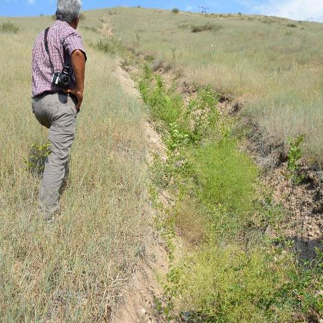
Site where a debris flow came down, land was rehabilitated and preventive measures implemented (Stefan Michel)

Disaster risk reduction and sustainable land-use by integrated rehabilitation of flashflood/debris flow affected site (ຕາຈິກິສະຕານ)

Снижение риска стихийных бедствий и устойчивое землепользование через интегрированное восстановление местности разрушенного селевым потоком

ຄຳອະທິບາຍ

A site affected by a debris flow was rehabilitated by joint communal work and integrated preventive measures addressing the upper catchment as well as the valley and the debris conus were implemented in collaboration of community, individual farmers, Committee of Emergency Situations and forestry enterprise.

Local people in many parts of Tajikistan, among these the project region at the northern main slope of the Turkestan range, report about formerly unknown flashfloods and debris flows, even in areas where such events are not remembered. Also relief, soil and vegetation often confirm that such sites for long times had not been transformed by these forces. The occurrence of flashfloods and debris flows in formerly not affected areas, unusual seasons or an increase in frequency and destructiveness of such events can be attributed to land degradation in upper catchment areas in combination with climate change impact.

The degradation of the vegetation in upper catchments has contributed to reduced infiltration of water and high and fast surface runoff. Important elements of this degradation are overgrazing and deforestation. Overgrazing and out of season grazing cause the reduction of the protective plant cover and the multiple trails of livestock with compressed soil reduce infiltration and increase the surface runoff. Deforestation is typically related to intensive livestock grazing, in particular by goats, as intensive browsing prevents the regeneration of shrub and tree vegetation. In upper catchments affected by these processes during heavy rainfall and snow melt large amounts of water concentrate in small valleys and take with them large amounts of soil and gravel. The deforestation in valleys contributes to the intensity of such flashfloods and debris flows.

The frequency and intensity of these events is increasingly exacerbated by the impact of climate change. The already visible trends and predictions show higher levels of aridity, higher temperatures during the vegetation season, reduced overall precipitation in catchment areas – all affecting the retention potential of upper catchment areas – and more irregular rainfall patterns, reduced snow packs and accelerated snow melt as well as the loss of glaciers as buffers of water flow. These factors all contribute to a higher frequency and intensity of flashflood and debris flows and their occurrence in previously not or less affected areas.

Near the village Shamoli in Shakhriston district, as in many other locations, such a debris flow made a road impassable and has destroyed pasture lands and five hectares of arable lands belonging to several farmers with another 10 ha being at risk in case such events occur again. Local people assisted by the Committee of Emergency Situations opened and cleaned the road. The developed in collaboration with experts an integrated approach for rehabilitating the affected lands and reducing the disaster risk. The approach included the following elements:
•Blocking of gullies with planting of willows for reducing sediment load in case of future flashfloods;
•Agreement with the forestry enterprise about general regulation of grazing and tree planting (specifics to be decided by the forestry enterprise);
•Joint communal work (hashar) for cleaning affected arable lands from debris;
•Fencing of 4 ha lands in the valley leased by one farmer from the forestry enterprise for rehabilitation of protective vegetation and sustainable land use (orchard and hay making);
•Construction of reservoir for water collection from spring and use for drip irrigation of trees planted at the debris conus in the opening of the valley.

The approach brought together the Committee of Emergency Situations, the administrative communities, affected local people and the forestry enterprise. Assisted by experts provided by the project, the situation was jointly analyzed; risks identified and the integrated intervention planned. The project assisted with technical planning, construction supervision, purchase and transportation of construction materials. The community contributed about 30% of the overall costs, mainly in form of voluntary communal work, the so called hashar. One farmer leased the most critical area at the opening of the valley and took the responsibility for the maintenance of the area in exchange for the opportunity to use hay and fruits from the planted trees.

The approach is generally replicable. But in most such sites the upper catchment areas belong to different communities, often to different districts and substantial parts are located in neighboring Kyrgyzstan. Therefore addressing the degradation of these areas and a reduction of disaster risk through integrated watershed management in the entire catchments will require more collaboration across administrative boundaries and even national borders.
ສະຖານທີ່

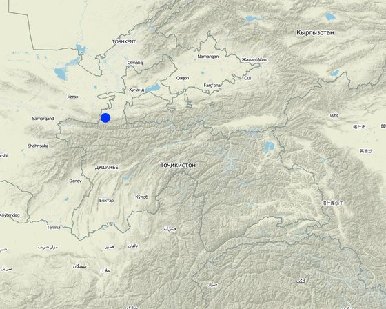
ສະຖານທີ່: Shahriston district; Shahriston sub-district, Shamoli site, Sughd region, ຕາຈິກິສະຕານ

ການຄັດເລືອກພື້ນທີ່ ທີ່ອີງໃສ່ຂໍ້ມູນທາງພູມີສາດ
  • 68.75322, 39.66991

ວັນທີເລີ່ມຕົ້ນ: 2017

ປີ​ຂອງ​ການ​ສິ້ນ​ສຸດ: n.a.

ປະເພດຂອງແນວທາງ
Blocking of gully with vegetative measures (Nodir Muhidinov)
Area affected by debris flow (Stefan Michel)

ເປົ້າໝາຍຂອງແນວທາງ ແລະ ການປົກປັກຮັກສາສິ່ງແວດລ້ອມ

ເປົ້າໝາຍ / ຈຸດປະສົງຫຼັກໃນການຈັດຕັ້ງປະຕິບັດແນວທາງ
Rehabilitation of land affected by debris flow and reduction of risk of future events.
ເງື່ອນໄຂທີ່ສະໜັບສະໜູນໃຫ້ການຈັດຕັ້ງປະຕິບັດເຕັກໂນໂລຢີ ບົນພື້ນຖານແນວທາງ
  • ການກໍ່ຕັ້ງສະຖາບັນ: Communal work for addressing issues affecting the entire community or individual members.
  • ການຮ່ວມມື / ການປະສານງານຂອງຜູ້ກ່ຽວຂ້ອງ: Collaboration between community members, community leadership, Committee for Emergency Situations and forestry enterprise.
  • ວຽກ, ມີກໍາລັງຄົນ: Communal work for addressing issues affecting the entire community or individual members.
ເງື່ອນໄຂທີ່ເຊື່ອງຊ້ອນໃຫ້ການຈັດຕັ້ງປະຕິບັດເຕັກໂນໂລຢີ ບົນພື້ນຖານແນວທາງ
  • ມີຄວາມສາມາດ / ເຂັ້າເຖິງຊັບພະຍາກອນດ້ານການເງິນ ແລະ ການບໍລິການ: For complex measures the financial assistance by the project was needed.
  • ຄວາມຮູ້ກ່ຽວກັບການຄຸ້ມຄອງ ທີ່ດິນແບບຍືນຍົງ, ການເຂົ້າເຖິງການສະໜັບສະໜູນ ທາງດ້ານວິຊາການ: Understanding of SLM issues insufficient, involvement of external experts needed.

ການມີສ່ວນຮ່ວມ ແລະ ບົດບາດຂອງພາກສ່ວນທີ່ກ່ຽວຂ້ອງທີ່ມີສ່ວນຮ່ວມ

ພາລະບົດບາດຂອງພາກສ່ວນທີ່ກ່ຽວຂ້ອງ ທີ່ມີສ່ວນຮ່ວມໃນການຈັດຕັ້ງປະຕິບັດແນວທາງ
ແມ່ນໃຜ / ພາກສ່ວນໃດ ທີ່ເປັນເຈົ້າການ ໃນການຈັດຕັ້ງປະຕິບັດ ວິທີການ? ລະບຸ ພາກສ່ວນທີ່ກ່ຽວຂ້ອງ ພັນລະນາ ບົດບາດ ໜ້າທີ່ ຂອງພາກສ່ວນທີ່ກ່ຽວຂ້ອງ
ຜູ້ນໍາໃຊ້ດິນໃນທ້ອງຖິ່ນ / ຊຸມຊົນທ້ອງຖິ່ນ Individual farmers and local community Discussion of rehabilitation and prevention measures; Implementation of works; Maintencance of site with protection plantation.
ຜູ້ຊ່ຽວຊານ ການນຄຸ້ມຄອງ ທີ່ດິນແບບຍືນຍົງ / ທີ່ປຶກສາດ້ານກະສິກໍາ Experts provided by GIZ Advise on disaster risk reduction, blocking of gullies, planting of trees, drip irrigation.
ອໍານາດ ການປົກຄອງທ້ອງຖິ່ນ Community administration, Committee of Emergency Situations, forestry enterprise Identification of risk sites; Design, planning and supervision of interventions; Lease of intervention site; Regulation of grazing and tree planting in upper catchment.
ອົງການຈັດຕັ້ງ ສາກົນ Deutsche Gesellschaft für Internationale Zusammenarbeit (GIZ) Overall project implementation; Technical planning and oversight; Procurement of construction materials via competitive bidding process
ອົງການທີ່ເປັນຕົວແທນໃນການຈັດຕັ້ງປະຕິບັດ
Deutsche Gesellschaft für Internationale Zusammenarbeit (GIZ)
ການລວບລວມເອົາຜູ້ນໍາໃຊ້ທີ່ດິນໃນທ້ອງຖິ່ນ/ຊຸມຊົນທ້ອງຖິ່ນ ໃນການຈັດຕັ້ງປະຕິບັດແນວທາງ ແຕ່ລະໄລຍະ
ບໍ່ມີ
ການບໍ່ປະຕິບັດ
ການຊ່ວຍເຫຼືອຈາກພາຍນອກ
ການຮ່ວມມື
ການນໍາໃໍຊ້ເອງ
ການເລີ່ມຕົ້ນ / ແຮງຈູງໃຈ
x
Local community members, asking community leadership and GIZ staff for assistance to address impact of debris flow
ການວາງແຜນ
x
Involvement of community members in planning
ແຜ່ນວາດສະແດງ

ການຕັດສິນໃຈໃນການເລືອກເຕັກໂນໂລຢີ ການຄຸ້ມຄອງທີ່ດິນແບບຍືນຍົງ

ການຕັດສິນໃຈໂດຍ

  • ຜູ້ນໍາໃຊ້ດິນຜູ້ດຽວ (ການລິເລີ່ມດ້ວຍຕົນເອງ)
  • ຜູ້ນໍາໃຊ້ທີ່ດິນຫຼັກ, ການສະໜັບສະໜູນ ໂດຍຜູ້ຊ່ຽວຊານ ການນໍາໃຊ້ທີ່ດິນແບບຍືນຍົງ
  • ພາກສ່ວນກ່ຽວຂ້ອງທັງໝົດ, ເປັນສ່ວນໜຶ່ງ ຂອງວິທີທາງແບບມີສ່ວນຮ່ວມ
  • ຜູ້ຊ່ຽວຊານ ຫຼັກດ້ານການຄຸ້ມຄອງ ທີ່ດິນແບບຍືນຍົງ, ມີການຕິດຕາມປຶກສາຫາລືກັບຜູ້ນໍາໃຊ້ທີ່ດິນ
  • ຊຽ່ວຊານ ສະເພາະດ້ານການຄຸ້ມຄອງ ດິນແບບຍືນຍົງຜູ້ດຽວ
  • ນັກການເມືອງ / ຜູ້ນໍາ

ການຕັດສິນໃຈບົນພື້ນຖານ

  • ປະເມີນເອກກະສານ ຄວາມຮູ້ກ່ຽວກັບ ການຄຸ້ມຄອງ ທີ່ດິນແບບຍືນຍົງ (ຫຼັກຖານທີ່ຊ່ວຍໃນການຕັດສິນໃຈ)
  • ຜົນທີ່ໄດ້ຮັບ ຈາກການຄົ້ນຄວ້າ
  • ປະສົບການສ່ວນບຸກຄົນ ແລະ ຄວາມຄິດເຫັນ (ທີ່ບໍ່ເປັນເອກກະສານ)

ການສະໜັບສະໜູນເຕັກໂນໂລຢີ, ການສ້າງຄວາມອາດສາມາດ ແລະ ການຄຸ້ມຄອງຄວາມຮູ້

ກິດຈະກຳ ດັ່ງລຸ່ມນີ້ ແມ່ນເປັນພາກໜຶ່ງຂອງແນວທາງ
ການບໍລິການທາງດ້ານການໃຫ້ຄໍາປຶກສາ
ໄດ້ຮັບການບໍລິການທາງດ້ານການໃຫ້ຄໍາປຶກສາ
  • ໃນພື້ນທີ່ຂອງຜູ້ນໍາໃຊ້ດິນ
  • ສູນຄົ້ນຄວ້າ
Not of specific relevance for this approach.
ຄວາມເຂັ້ມແຂງຂອງສະຖາບັນ
ສະຖາບັນ ໄດ້ຮັບການສ້າງຄວາມເຂັ້ມແຂງ
  • ບໍ່ມີ
  • ມີ, ໜ້ອຍໜຶ່ງ
  • ມີ, ພໍສົມຄວນ
  • ມີ, ຫຼາຍ
ໃນລະດັບດັ່ງລຸ່ມນີ້
  • ທ້ອງຖິ່ນ
  • ລະດັບພາກພື້ນ
  • ແຫ່ງຊາດ
ອະທິບາຍສະຖາບັນ, ພາລະບົດບາດແລະຄວາມຮັບຜິດຊອບ, ສະມາຊິກ, ແລະອື່ນໆ.
Existing community institutions have been strengthened through joint successful implementation of the works and the need for further collaboration.
ຮູບແບບການສະໜັບສະໜູນ
  • ທາງດ້ານການເງິນ
  • ການສ້າງຄວາມອາດສາມາດ / ການຝຶກອົບຮົມ
  • ອຸປະກອນ
ລາຍລະອຽດເພີ່ມເຕີມ
Fencing, materials of irrigation system, technical advice.
ການຕິດຕາມ ແລະ ປະເມີນຜົນ

ການສະໜັບສະໜູນທາງດ້ານການເງິນ ແລະ ອຸປະກອນຈາກພາຍນອກ

ງົບປະມານປະຈຳປີ ໃນກິດຈະກຳ ການຄຸ້ມຄອງທີ່ດິນແບບຍືນຍົງ ທີ່ເປັນສະກຸນເງິນໂດລາ
  • < 2,000
  • 2,000-10,000
  • 10,000-100,000
  • 100,000-1,000,000
  • > 1,000,000
Precise annual budget: n.a.
Government of Germany, implemented via Deutsche Gesellschaft für Internationale Zusammenarbeit (GIZ). The approach has been implemented in the frame of a much larger program and the specific budget for the SLM component of the Approach cannot be determined.
ການບໍລິການ ຫຼື ສິ່ງກະຕຸກຊຸກຍູ້ ດັ່ງລຸ່ມນີ້ ແມ່ນໄດ້ສະໜອງໂດຍຜູ້ນຳໃຊ້ທີ່ດິນເອງ
  • ການສະໜັບສະໜູນ ທາງດ້ານການເງິນ / ອຸປະກອນ ສະໜອງໃຫ້ແກ່ຜູ້ນໍາທີ່ດິນ
  • ຫຼຸດປັດໃຈນໍາເຂົ້າ
  • ສິນເຊື່ອ
  • ສິ່ງຈູງໃຈ ຫຼື ເຄື່ອງມືອື່ນໆ
ເງິນສະໜັບສະໜູນອຸປະກອນ / ສະໜອງໃຫ້ຜູ້ຊົມໃຊ້ທີ່ດິນ
Technical planning and supervision, procurement of materials and transportation funded by GIZ.
ສີ່ງກະຕຸກຊຸກຍູ້ອື່ນໆ

The farmer managing the site in the valley, where trees have been planted, can use the fruits and the hay produced from the site. This is the key incentive for him to carry out all maintenance.

ການວິເຄາະຜົນກະທົບ ແລະ ສະຫຼຸບລວມ

ຜົນກະທົບຂອງການນໍາໃຊ້ແນວທາງ
ບໍ່
ມີ, ໜ້ອຍໜຶ່ງ
ມີ, ພໍສົມຄວນ
ມີ, ຫຼາຍ
ວິທີທາງ ຊ່ວຍຊຸກຍູ້ ຜູ້ນຳໃຊ້ທີ່ດິນທ້ອງຖີ່ນ, ໃນການປັບປຸງ ການມີສ່ວນຮ່ວມ ຂອງຜູ້ທີ່ກ່ຽວຂ້ອງ ບໍ່?

Mobilization for joint work to address problems affecting all farmers/community members

x
ການຈັດຕັ້ງປະຕິບັດ ວິທີທາງ ສາມາດຊ່ວຍຜູ້ນໍາໃຊ້ທີ່ດິນ ໃນການຈັດຕັ້ງປະຕິບັດ ແລະ ບໍາລຸງຮັກສາ ເຕັກໂນໂລຢີ ການຄຸ້ມຄອງ ທີ່ດິນແບບຍືນຍົງໄດ້ບໍ?

Integration of different technologies to rehabilitate lands and reduce future disaster risk.

x
ການນໍາໃຊ້ ວິທີທາງ ສາມາດປັບປຸງ ການປະສານງານ ແລະ ຄ່າໃຊ້ຈ່າຍ ການຈັດຕັ້ງປະຕິບັດ ທີ່ມີປະສິດທິພາບ ຂອງການຄຸ້ມຄອງ ທີ່ດິນແບບຍືດຍົງໄດ້ບໍ່?

Collaboration between land users, community leadership, Committee of Emergency Situations and forestry enterprise.

x
ການນໍາໃຊ້ ວິທີທາງ ສາມາດລະດົມ ຫຼື ປັບປຸງ ການເຂົ້າເຖິງຊັບພະຍາກອນ ການເງິນ ສໍາລັບການຈັດຕັ້ງປະຕິບັດ ການຄຸ້ມຄອງ ທີ່ດິນແບບຍືດຍົງໄດ້ບໍ່?

Mobilization of financial resources from GIZ.

x
ການນໍາໃຊ້ ວິທີທາງ ສາມາດປັບປຸງຄວາມຮູ້ ແລະ ຄວາມສາມາດຂອງຜູ້ນໍາໃຊ້ທີ່ດິນ ໃນການປະຕິບັດ ການຄຸ້ມຄອງ ທີ່ດິນແບບຍືດຍົງໄດ້ບໍ່?

Knowledge of and skills to implement several technologies for land rehabilitation, sustainable land use and disaster risk reduction.

x
ການນໍາໃຊ້ ວິທີທາງ ສາມາດສ້າງຄວາມເຂັ້ມແຂງ ໃຫ້ສະຖາບັນການຈັດຕັ້ງ, ການຮ່ວມມື ລະຫວ່າງພາກສ່ວນທີ່ກ່ຽວຂ້ອງບໍ່?

Collaboration between land users, community leadership, Committee of Emergency Situations and forestry enterprise.

x
ການຈັດຕັ້ງປະຕິບັດ ວິທີທາງ ສາມາດປັບປຸງ ປະເດັນການຖືຄອງທີ່ດິນ / ສິດທິໃນການນໍາໃຊ້ທີ່ດິນ ທີ່ເຊື່ອງຊ້ອນໃນການຈັດຕັ້ງປະຕິບັດ ເຕັກໂນໂລຢີ ການຄຸ້ມຄອງ ທີ່ດິນແບບຍືນຍົງໄດ້ບໍ?

Lease of critical site to motivated farmer by forestry enterprise.

x
ການນໍາໃຊ້ ວິທີທາງ ໄດ້ປັບປຸງ ການຄໍ້າປະກັນສະບຽງອາຫານ ຫຼື ປັບປຸງໂຄສະນາການໄດ້ບໍ່?

Rehabilitation of affected farmlands and reduced disaster risk.

x
ການຈັດຕັ້ງປະຕິບັດ ວິທີທາງ ສາມາດສ້າງຄວາມອາດສາມາດໃຫ້ຜູ້ນໍາໃຊ້ດິນ ໃນການປັບຕົວ ຕໍ່ການປ່ຽນແປງດິນຟ້າອາກາດ / ຫຼດຜ່ອນຄວາມສ່ຽງທາງໄພພິບັດໄດ້ບໍ?

Reduced risk of disasters, which increase due to climate change.

x
ສິ່ງກະຕຸກຊຸກຍູ້ໃຫ້ຜູ້ນໍາໃຊ້ທີ່ດິນ ໃນການປະຕິບັດການຄຸ້ມຄອງທີ່ດິນແບບຍືນຍົງ
ຄວາມຍືນຍົງຂອງການຈັດຕັ້ງປະຕິບັດກິດຈະກໍາຂອງແນວທາງ
ຜູ້ນໍາໃຊ້ທີ່ດິນ ສາມາດຈັດຕັ້ງປະຕິບັດຕາມແນວທາງໄດ້ເອງບໍ່ (ໂດຍປາດສະຈາກການສະໜັບສະໜູນຈາກພາກສ່ວນພາຍນອກ)?

ບົດສະຫຼຸບ ແລະ ບົດຮຽນທີ່ໄດ້ຮັບ

ຄວາມເຂັ້ມແຂງ: ທັດສະນະມູມມອງ ຂອງຜູ້ນໍາໃຊ້ທີ່ດິນ
  • Rehabilitated lands and reduced risk.
  • Use of products from critical site, which was planted with fruit trees.
ຄວາມເຂັ້ມແຂງ: ທັດສະນະມຸມມອງ ຂອງຜູ້ປ້ອນຂໍ້ມູນເອງ
  • Same as land users' view.
  • Mobilization of collaboration and joint communal work.
ຈຸດອ່ອນ / ຂໍ້ເສຍ / ຄວາມສ່ຽງ: ທັດສະນະມູມມອງ ຂອງຜູ້ນໍາໃຊ້ທີ່ດິນວິທີການແກ້ໄຂແນວໃດ
  • High costs of fencing External funding.
  • High costs of irrigation system External funding.
ຈຸດອ່ອນ / ຂໍ້ເສຍ / ຄວາມສ່ຽງ: ທັດສະນະມຸມມອງ ຂອງຜູ້ປ້ອນຂໍ້ມູນເອງວິທີການແກ້ໄຂແນວໃດ
  • High costs of fencing External funding;
    Cheaper temporary electric fencing;
    Approaches without fencing, based on agreement in the community to prevent livestock damage through herding.
  • High costs of irrigation system External funding;
    Planting of drought resistant trees.

ເອກກະສານອ້າງອີງ

ການລວບລວມ
  • Stefan Michel
Editors
ການທົບທວນຄືນ
  • Umed Vahobov
ວັນທີຂອງການປະຕິບັດ: Jan. 15, 2019
ປັບປຸງລ່າສຸດ: Jan. 31, 2019
ບຸກຄົນທີ່ສໍາຄັນ
ການບັນຍາຍລາຍລະອຽດ ໃນຖານຂໍ້ມູນ ຂອງ WOCAT
ຂໍ້ມູນການເຊື່ອມໂຍງຂໍ້ມູນການຄຸ້ມຄອງການນໍາໃຊ້ດິນແບບຍືນຍົງ
ເອກກະສານ ແມ່ນໄດ້ອໍານວຍຄວາມສະດວກໂດຍ
ສະຖາບັນ ​ໂຄງ​ການ
This work is licensed under Creative Commons Attribution-NonCommercial-ShareaAlike 4.0 International