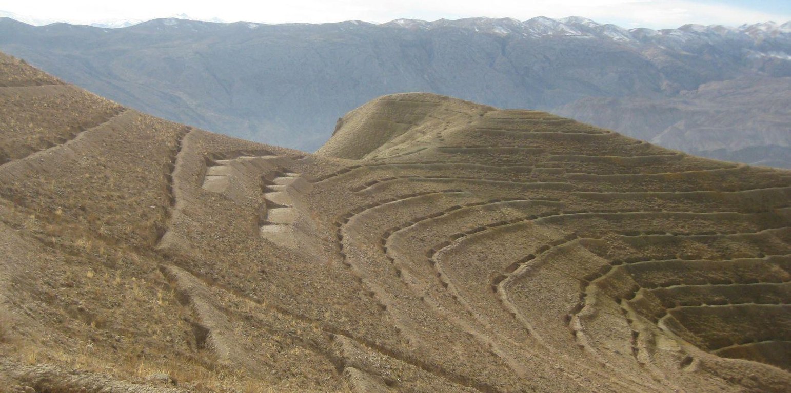
An overview of continuous contour trenches at Sourakhak watershed. Also in picture are a few terraces (HELVETAS Swiss Intercooperatio)
Contour Tied Trenches (CTT) were constructed to trap and retain surface runoff and sediments with the main objective of reducing flash flood risks from the Sou-rakhak watershed which was badly degraded due to overgrazing, excessive cutting of shrubs for fuel wood, rainfed cropping and recurring droughts. The technology was combined with other structural measures like soil bunds, check dams, water ponds, and plantation of fruit, non-fruit trees, fodder crops like alfalfa, Asafoetida and Cumin as cash crops. The watershed is also protected from grazing and shrub cutting by the participating communities. Community bakeries were constructed in the valleys and bio-briquette technology promoted for reducing shrub consump-tion/cutting.
Purpose of the Technology: Continuous Contour Trench (CCT) technology was applied to trap and retain surface runoff and sediments with the main objective of reducing flash flood risks from Sourakhak watershed and preventing damages due to flash floods in the valleys.
Establishment / maintenance activities and inputs: Feasibility studies were conducted and workers from three Community Develop-ment Councils (CDCs) of Roy-e Sang (Kahmard) implemented the construction works based on the technical proposals. The workers were organised by the Sourakhak watershed management committee and they got a daily wage of USD 5 for their labour inputs. About 670 families (276 person days/ha) participated in the construction of CTTs and other technologies.
One supervisor appointed by the communities and a watershed worker from HEL-VETAS Swiss Intercooperation side, both paid by the project, monitored the water-shed works with technical advice from the project staff. The work was carried out in phases and in 4 years (starting 2009) about 65,000 trenches were constructed. About 216 trenches were constructed per hectare and the construction cost was about 1450 USD/ha, which included 1380 USD for labour and 70 USD for tools. The International Swiss Re Award (2009), the Swiss Agency for Development and Cooperation (SDC), HELVETAS Swiss Intercooperation and the participating families financially contributed to the watershed management works.
Natural / human environment: Sourakhak watershed has a semi-arid and temperate climate. The area receives up to 400 mm rainfall (annually) and snow during winter time. The watershed elevation ranges from 2000-3000 m amsl and soil type is sandy-loam to clay type. The land users who applied thsi technology are mostly smallholders. The uplnad areas where the technology was applied is owned by the state, but local communities have long term land use rights.
Sourakhak watershed has a semi-arid and temperate climate. The area receives up to maximum 400 mm rainfall annually in a normal year and snow during winter. About 80% of the rain falls from March to June, with most rain falling in the months of April and May. The watershed is located at an elevation ranging from 2000-3000 m (amsl) and the soil is sandy-loam to clay type. The land users who applied the CTTs are mostly smallholders (with less than 1 ha irrigated land) and they reside in the valley bottoms. The upland areas, where the CTT have been constructed, belong to the state but the local communities have land and water use rights. From a climate change perspective, CTTs will not be much affected by temperature changes or drought. Some trenches could break if there is an extreme rainfall event.
ສະຖານທີ່: Kahmard district, Bamyan Province, ອັຟການີດສະຖານ
ຈໍານວນ ພື້ນທີ່ ທີ່ໃຊ້ ເຕັກໂນໂລຢີ ທີ່ໄດ້ວິເຄາະ:
ການແຜ່ກະຈາຍຂອງເຕັກໂນໂລຢີ: ແຜ່ຂະຫຍາຍຢ່າງໄວວາໃນພື້ນທີ່ (3.0 km²)
ຢູ່ໃນເຂດປ່າສະຫງວນທີ່ບໍ?:
ວັນທີຂອງການປະຕິບັດ: ຕໍ່າກວ່າ 10 ປີ ຜ່ານມາ (ມາເຖິງປະຈຸບັນ)
ປະເພດຂອງການນໍາສະເໜີ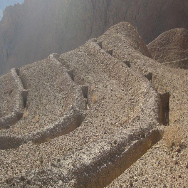


| ລະບຸ ປັດໃຈ ນໍາເຂົ້າ ໃນການຜະລີດ | ຫົວໜ່ວຍ | ປະລິມານ | ຕົ້ນທຶນ ຕໍ່ຫົວໜ່ວຍ (USA) | ຕົ້ນທຶນທັງໝົດ ຂອງປັດໃຈຂາເຂົ້າ ໃນການຜະລິດ (USA) | % ຂອງຕົ້ນທຶນທັງໝົດ ທີ່ຜູ້ນໍາໃຊ້ທີ່ດິນ ໃຊ້ຈ່າຍເອງ |
| ແຮງງານ | |||||
| Construction of trenches | persons/day/ha | 276.0 | 5.0 | 1380.0 | 10.0 |
| ອຸປະກອນ | |||||
| Tools | ha | 1.0 | 70.0 | 70.0 | 90.0 |
| ຕົ້ນທຶນທັງໝົດ ໃນການຈັດຕັ້ງປະຕິບັດ ເຕັກໂນໂລຢີ | 1'450.0 | ||||
| ຄ່າໃຊ້ຈ່າຍທັງໝົດ ສຳລັບການສ້າງຕັ້ງເຕັກໂນໂລຢີ ເປັນສະກຸນເງີນໂດລາ | 1'450.0 | ||||
| ລະບຸ ປັດໃຈ ນໍາເຂົ້າ ໃນການຜະລີດ | ຫົວໜ່ວຍ | ປະລິມານ | ຕົ້ນທຶນ ຕໍ່ຫົວໜ່ວຍ (USA) | ຕົ້ນທຶນທັງໝົດ ຂອງປັດໃຈຂາເຂົ້າ ໃນການຜະລິດ (USA) | % ຂອງຕົ້ນທຶນທັງໝົດ ທີ່ຜູ້ນໍາໃຊ້ທີ່ດິນ ໃຊ້ຈ່າຍເອງ |
| ແຮງງານ | |||||
| Repair trenches | persons/day/ha | 1.0 | 5.0 | 5.0 | 100.0 |
| ຕົ້ນທຶນທັງໝົດ ທີ່ໃຊ້ໃນການບໍາລຸງຮັກສາ ເຕັກໂນໂລຢີ | 5.0 | ||||
| ຄ່າໃຊ້ຈ່າຍທັງໝົດ ສຳລັບການບົວລະບັດຮກສາເຕັກໂນໂລຢີ ເປັນສະກຸນເງີນໂດລາ | 5.0 | ||||
Increase in natural production due to increased moisture and area protection
As the area is closed for grazing and shrub cutting
Work is facilitated by watershed management committee
It has reduced flash flood risks. As a result, more area in the valleys is productive and damages to houses, roads, gardens, agriculture land have significantly reduced
Due to less flash floods


