Dug-Out Well
(ອິນເດຍ)
Chahala
ຄຳອະທິບາຍ
It can be defined as combination of structural & agronomic measures where along with other technology like Water harvesting structures & field bunding on the upper reaches & a dug out well is constructed in the periphery of the drainage line which is a govt land. The 15 acres of land near to its sphere of influence which reamained fallow earlier could yield good production system throughout the year.It is in the semi-arid climatic zone with moderate slope in medium soil depth conditions. The whole idea is to avail water & link with self-subsistance & market oriented production systems from private lands.
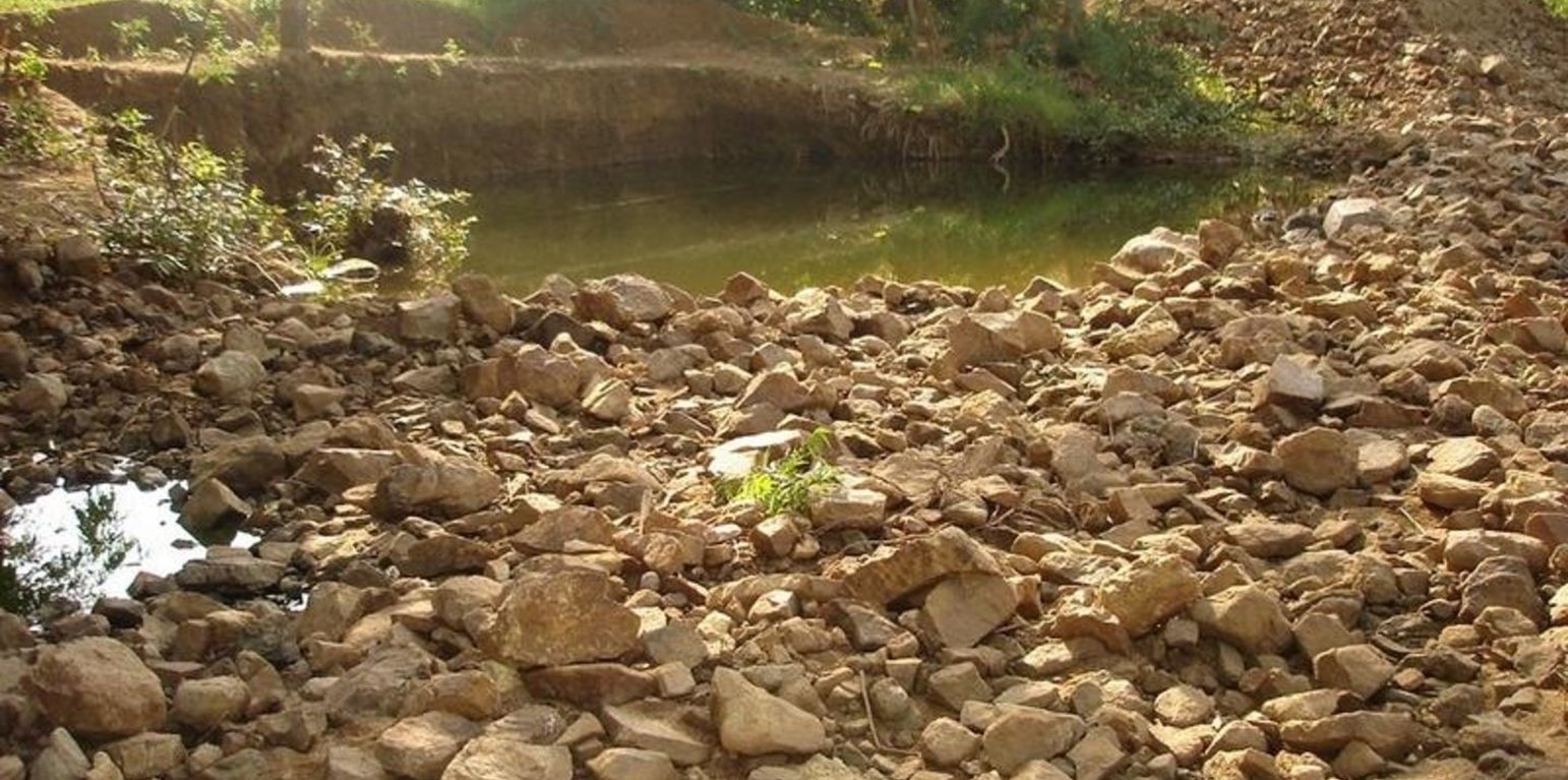
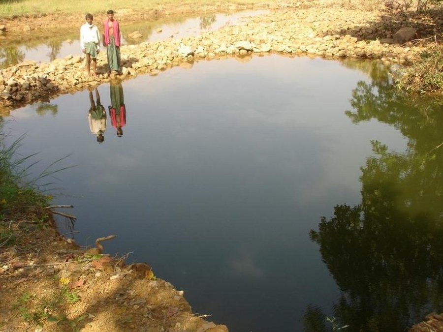
The area is located at the foot-slopes on the major drainage line of the watershed. The technology area is located near the main drainage line, therefore, the sub-surface water availability is more & can be utilised for cultivation of crop even in dry spell of the year. Earlier the farmers near to this place tried to dig a small well & could irrigate for only 2-3 months of the year to get some subsistence crops. Therefore, water availability throughout the year is a first priority of the farmers. At the outset, a livelihood focused micro-plan had been prepared by the villagers stating the details of the base-line data along with problems & alternative solutions. The patch was identified to be the worst affected & the owners of the land are poor people (defined by villagers). Usually the land users used to migrate in search of labour due to loss in the agriculture. It is because the water availability is not there at the time of requirement. The people of this patch are ready to contribute at least 10% of the cost as the structure is to be constructed in government land. In the mean time the project sent the PIA to Water technology centre for eastern region, Bhubneswar to study the linking of water harvesting structure & dug-out well & its relevance in this context of our situation. The technology was done in the village Chareimara which is one out of 3 villages of one watershed, located at the lower reach of the watershed. In the meantime many water harvesting structures & field bunds were constructed due to which the water could be stored in the recharge zone. This area is again a mix of stony patches in the crop land. One water harvesting structure was constructed just at the upper reaches. The surrounding area was totally unbunded with clay loam soil. Therefore, land users are of opinion to go for a deeper dug well which can feed water through out to at least 15 acre of land. The requirement of land users was to get some water in each farmers land to protect the Kharif & rabi crop including summer vegetables. A four-day in field training was conducted by the project to community link workers (SWC), particularly on patch treatment, use of levelling instruments like A-frame, proper planning, design, lay-out of different type of structure in a map & ground. At the same time there was a blind belief that large water harvesting structures are more useful to farmers. So the land users demanded for a large WHS on the drainage bed which requires huge investment & high maintenance cost. But when some farmers of that watershed could get good result by digging well these land users also started thinking about a "community dug-well". After many rounds of discussion with the land users by the SWC specialist followed by a detail transact along with land users, the results of first round transact was mentioned in the micro-plan. But the aim behind subsequent transact was to looking at problems & demarcating on the map. After that estimate was prepared & lay-out of the well was done by SWC specialist with the help of community link workers & land users. The lay-out is also little bit different from traditional well i.e. square shaped in stead of round shape. The work was implemented by the land users & 7 outside labourers with the supervision of the User's group leader & monitoring was done by the SWC specialist. The priority by the land users was agronomic measures like changing the crop in the land. Training was conducted on the probable alternatives of agronomic measures like taking of crop which is of little longer duration, intercrops & cash crops etc. The structural measures are subsidised by the project & the agronomic measures was taken up on loan basis. The development fund was also generated out of contribution from the land users which was deposited in a separate account for future maintenance cost.
ສະຖານທີ່
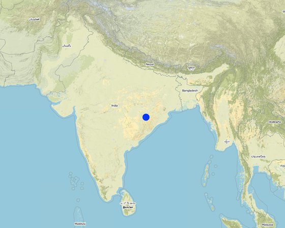
ສະຖານທີ່: Orissa, Balangir, Suktel/Mahanadi, ອິນເດຍ
ຈໍານວນ ພື້ນທີ່ ທີ່ໃຊ້ ເຕັກໂນໂລຢີ ທີ່ໄດ້ວິເຄາະ:
ການຄັດເລືອກພື້ນທີ່ ທີ່ອີງໃສ່ຂໍ້ມູນທາງພູມີສາດ
ການແຜ່ກະຈາຍຂອງເຕັກໂນໂລຢີ: ແຜ່ຂະຫຍາຍຢ່າງໄວວາໃນພື້ນທີ່ (0.6 km²)
ຢູ່ໃນເຂດປ່າສະຫງວນທີ່ບໍ?:
ວັນທີຂອງການປະຕິບັດ: ຕໍ່າກວ່າ 10 ປີ ຜ່ານມາ (ມາເຖິງປະຈຸບັນ)
ປະເພດຂອງການນໍາສະເໜີ
-
ໂດຍຜ່ານນະວັດຕະກໍາຄິດຄົ້ນຂອງຜູ້ນໍາໃຊ້ທີ່ດິນ
-
ເປັນສ່ວນໜື່ງຂອງລະບົບພື້ນເມືອງ (>50 ປີ)
-
ໃນໄລຍະການທົດລອງ / ການຄົ້ນຄວ້າ
-
ໂດຍຜ່ານໂຄງການ / ການຊ່ວຍເຫຼືອຈາກພາຍນອກ
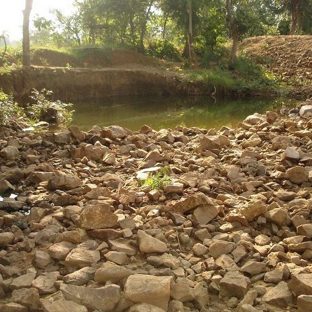
Dug Well in Chareimara
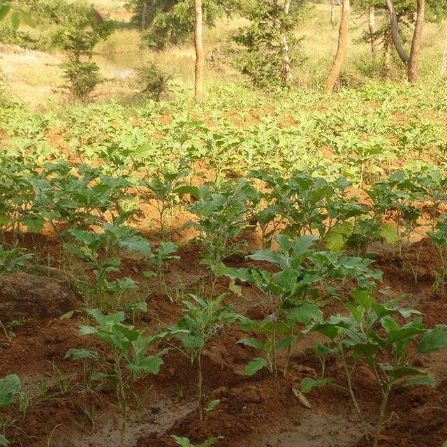
Land irrigated from well
ຈຸດປະສົງຕົ້ນຕໍ
-
ປັບປຸງ ການຜະລິດ
-
ຫຼຸດຜ່ອນ, ປ້ອງກັນ, ຟື້ນຟູ ການເຊື່ອມໂຊມຂອງດິນ
-
ການອະນຸລັກ ລະບົບນິເວດ
-
ປົກປັກຮັກສານໍ້າ / ນໍ້າພື້ນທີ່ - ປະສົມປະສານກັບ ເຕັກໂນໂລຢີອື່ນໆ
-
ປົກປັກຮັກສາ / ການປັບປຸງຊີວະນາໆພັນ
-
ຫຼຸດຜ່ອນຄວາມສ່ຽງ ທາງໄພພິບັດທໍາມະຊາດ
-
ປັບຕົວຕໍ່ກັບການປ່ຽນແປງດິນຟ້າອາກາດ / ທີ່ຮ້າຍແຮງ ແລະ ຜົນກະທົບ
-
ຫຼຸດຜ່ອນຜົນກະທົບ ຈາກການປ່ຽນແປງດິນຟ້າອາກາດ
-
ສ້າງຜົນກະທົບ ທາງເສດຖະກິດ ທີ່ເປັນປະໂຫຍດ
-
ສ້າງຜົນກະທົບ ທີ່ເປັນທາງບວກ ໃຫ້ແກ່ສັງຄົມ
ການນໍາໃຊ້ດິນ
-
ດິນທີ່ປູກພືດ
- ການປູກພືດປະຈໍາປີ: ຜັກ-ໝາກໂມ, ໝາກອື, ໝາກບວບ ຫຼື ໝາກນ້ຳ, ຜັກ-ອື່ນໆ, ຜັກ-ຜັກໃຫ້ຫົົວ ( ກາລົດ, ຜັກບົ່ວຫົວໃຫ່ຍ, ຜັກກາດຫວານ, ອື່ນໆ), rice
- ພືດຢືນຕົ້ນ (ບໍ່ແມ່ນໄມ້): ຕົ້ນອ້ອຍ
ຈໍານວນ ລະດູການ ປູກໃນປີໜຶ່ງ: 2
ມີການເຝືກປູກພືດແບບສັບຫວ່າງບໍ່? ແມ່ນ
ການສະໜອງນໍ້າ
-
ນໍ້າຝົນ
-
ປະສົມປະສານ ກັນລະຫວ່າງ ນໍ້າຝົນ ແລະ ນໍ້າຊົນລະປະທານ
-
ນໍາໃຊ້ ນໍ້າຊົນລະປະທານ ພຽງຢ່າງດຽວ
-
all of them
ຈຸດປະສົງທີ່ກ່ຽວຂ້ອງກັບການເຊື່ອມໂຊມຂອງດິນ
-
ປ້ອງກັນການເຊື່ອມໂຊມຂອງດິນ
-
ຫຼຸດຜ່ອນການເຊື່ອມໂຊມຂອງດິນ
-
ການຟື້ນຟູ / ຟື້ນຟູດິນທີ່ຊຸດໂຊມ
-
ປັບຕົວຕໍ່ການເຊື່ອມໂຊມຂອງດິນ
-
ບໍ່ສາມາດໃຊ້ໄດ້
ການເຊື່ອມໂຊມ ທີ່ຕ້ອງໄດ້ເອົາໃຈໃສ່
-
ດິນເຊາະເຈື່ອນ ໂດຍນໍ້າ - Wr: ແຄມຕາຝັ່ງເຈື່ອນ
ກຸ່ມການຄຸ້ມຄອງທີ່ດິນແບບຍືນຍົງ
ມາດຕະການ ການຄຸ້ມຄອງທີ່ດິນແບບຍືນຍົງ
-
ມາດຕະການ ທາງການກະສິກໍາ - A1: ພືດ / ການປົກຫຸ້ມຂອງດິນ, A2: ອິນຊີວັດຖຸ ຫຼື ຄວາມອຸດົມສົມບູນໃນດິນ , A5: ການຈັດການ ແລະ ການປັບປຸງແກ່ນເມັດພັນ ແລະ ແນວພັນ, A7: ອື່ນໆ
ເທັກນິກການແຕ້ມຮູບ
ຂໍກຳນົດທາງເທັກນິກ
Dug Well in Chareimara
Technical knowledge required for field staff / advisors: low
Technical knowledge required for land users: low
Main technical functions: control of dispersed runoff: retain / trap, water harvesting / increase water supply
Secondary technical functions: control of concentrated runoff: impede / retard, water spreading
Better crop cover
Material/ species: paddy, vegetables,
Quantity/ density: Average
Remarks: Paddy for subsistence & vegetables in the land with rainfed & market demand.
Mixed cropping / intercropping
Material/ species: Gourd, Brinjal, onion, sugarcane,water melon
Quantity/ density: ealy harve
Remarks: After the Kharif crop
Manure / compost / residues
Material/ species: 4 -5 cartloads of cow-dung
Mineral (inorganic) fertilizers
Material/ species: Minimum basal doses
Rotations / fallows
Material/ species: the cultivation of crop started after the availability of water.
Remarks: Rainfed paddy with vegetables
Breaking compacted topsoil
Remarks: As the land was fallow earlier, breaking of compact soil is necessary.
Deep tillage / double digging
Remarks: The land where vegetables was grown, deep tillage was required
Structural measure: diversion ditch / cut-off drain
Depth of ditches/pits/dams (m): 26ft
Width of ditches/pits/dams (m): 35ft
Length of ditches/pits/dams (m): 33ft
Construction material (stone): Stone excavetd from the well was put as protection embankment
Construction material (concrete): A concrete guard wall will be put on the periphery of well which will be started in the current year
For water harvesting: the ratio between the area where the harvested water is applied and the total area from which water is collected is: 1:150
Change of land use type: After paddy & kharif vegetables,rabi & summer vegetables .Th e bunds of the patch need to be covered with plants
Change of land use practices / intensity level: Inter crops, mixed crops have to be practiced to get optimum benefit.
Layout change according to natural and human environment: Grazing was restricted in these areas & land was optimally used, like bund cultivation.
Major change in timing of activities: Early varieties of vegetables will fetch at least double benefit.
Control / change of species composition: The improved varities seed need to be introduced
ການຈັດຕັ້ງ ແລະ ບໍາລຸງຮັກສາ: ກິດຈະກໍາ, ວັດຖຸດິບ ແລະ ຄ່າໃຊ້ຈ່າຍ
ການຄຳນວນ ປັດໃຈການຜະລິດ ແລະ ຄ່າໃຊ້ຈ່າຍ
- ຄິດໄລ່ຄ່າໃຊ້ຈ່າຍ:
- ສະກຸນເງິນທີ່ໃຊ້ສໍາລັບການຄິດໄລ່ຄ່າໃຊ້ຈ່າຍ: Rupee
- ອັດຕາແລກປ່ຽນ (ເປັນເງີນ ໂດລາ): 1 USD = 50.0 Rupee
- ຄ່າແຮງງານສະເລ່ຍ ຂອງການຈ້າງແຮງງານຕໍ່ມື້: 1.00
ປັດໄຈທີ່ສໍາຄັນສຸດທີ່ສົ່ງຜົນກະທົບຕໍ່ຄ່າໃຊ້ຈ່າຍ
Stones are to be excavated from such a height of 26 ft.
ກິດຈະກໍາການສ້າງຕັ້ງ
-
Survey (ໄລຍະເວລາ / ຄວາມຖີ່: April-May)
-
Demarkation on map (ໄລຍະເວລາ / ຄວາມຖີ່: April-May)
-
Estimate & lay-Out (ໄລຍະເວລາ / ຄວາມຖີ່: April-May)
-
Implementation of work (ໄລຍະເວລາ / ຄວາມຖີ່: May-July)
-
Survey & demarkation of water line (ໄລຍະເວລາ / ຄວາມຖີ່: April)
-
Digging of well (ໄລຍະເວລາ / ຄວາມຖີ່: May-July)
-
Water-way (ໄລຍະເວລາ / ຄວາມຖີ່: August)
ປັດໄຈນໍາເຂົ້າໃນການຈັດຕັ້ງ ແລະ ຄ່າໃຊ້ຈ່າຍ
| ລະບຸ ປັດໃຈ ນໍາເຂົ້າ ໃນການຜະລີດ |
ຫົວໜ່ວຍ |
ປະລິມານ |
ຕົ້ນທຶນ ຕໍ່ຫົວໜ່ວຍ (Rupee) |
ຕົ້ນທຶນທັງໝົດ ຂອງປັດໃຈຂາເຂົ້າ ໃນການຜະລິດ (Rupee) |
% ຂອງຕົ້ນທຶນທັງໝົດ ທີ່ຜູ້ນໍາໃຊ້ທີ່ດິນ ໃຊ້ຈ່າຍເອງ |
|
ແຮງງານ
|
| Medium |
hectare |
1.0 |
1250.0 |
1250.0 |
|
| ຕົ້ນທຶນທັງໝົດ ໃນການຈັດຕັ້ງປະຕິບັດ ເຕັກໂນໂລຢີ |
1'250.0 |
|
| ຄ່າໃຊ້ຈ່າຍທັງໝົດ ສຳລັບການສ້າງຕັ້ງເຕັກໂນໂລຢີ ເປັນສະກຸນເງີນໂດລາ |
25.0 |
|
ກິດຈະກໍາບໍາລຸງຮັກສາ
-
Ploughing (ໄລຍະເວລາ / ຄວາມຖີ່: April-May /)
-
Intercultural operation with manure & compost application (ໄລຍະເວລາ / ຄວາມຖີ່: June /)
-
Sowing of paddy & rainfed vegetables (ໄລຍະເວລາ / ຄວາມຖີ່: July & sep for two crops /)
-
weeding & intercultural operation, if required. (ໄລຍະເວລາ / ຄວາມຖີ່: July /)
-
Harvesting of paddy orvegetables or sugarcane. (ໄລຍະເວລາ / ຄວາມຖີ່: Nov /)
-
Winter early variety vegetables like onion, brinjal, leafy vegetables, gourds etc. (ໄລຍະເວລາ / ຄວາມຖີ່: Dec /)
-
Harvesting of winter spices & vegetables (ໄລຍະເວລາ / ຄວາມຖີ່: Feb-March /)
-
Sowing of summer vegetables like water melon etc (ໄລຍະເວລາ / ຄວາມຖີ່: March /)
-
Intercultural operation (ໄລຍະເວລາ / ຄວາມຖີ່: April /)
-
Harvesting of vegetables (ໄລຍະເວລາ / ຄວາມຖີ່: May /)
-
Management of surplus water (ໄລຍະເວລາ / ຄວາມຖີ່: Rainy Season/annual)
-
Collapsing of bund (ໄລຍະເວລາ / ຄວາມຖີ່: annual)
-
Well must be desilted (ໄລຍະເວລາ / ຄວາມຖີ່: Dry season/each cropping season)
-
Control of surplus water-flow (ໄລຍະເວລາ / ຄວາມຖີ່: August-Sep / annual)
-
Stabilisation of bund at weak points (ໄລຍະເວລາ / ຄວາມຖີ່: Nov-Dec / annual)
-
Desiltation of well (ໄລຍະເວລາ / ຄວາມຖີ່: April-may / annual)
ສະພາບແວດລ້ອມທໍາມະຊາດ
ສະເລ່ຍປະລິມານນໍ້າຝົນປະຈໍາປີ
-
< 250 ມີລິແມັດ
-
251-500 ມີລິແມັດ
-
501-750 ມີລິແມັດ
-
751-1,000 ມີລິແມັດ
-
1,001-1,500 ມີລິແມັດ
-
1,501-2,000 ມີລິແມັດ
-
2,001-3,000 ມີລິແມັດ
-
3,001-4,000 ມີລິແມັດ
-
> 4,000 ມີລິແມັດ
ເຂດກະສິກໍາ-ສະພາບອາກາດ
-
ຄວາມຊຸ່ມ
-
ເຄີ່ງຄວາມຊຸ່ມ
-
ເຄິ່ງແຫ້ງແລ້ງ
-
ແຫ້ງແລ້ງ
ຂໍ້ມູນຈໍາເພາະກ່ຽວກັບສະພາບອາກາດ
n.a.
ຄວາມຄ້ອຍຊັນ
-
ພື້ນທີ່ຮາບພຽງ (0-2%)
-
ອ່ອນ (3-5 %)
-
ປານກາງ (6-10 %)
-
ມ້ວນ (11-15 %)
-
ເນີນ(16-30%)
-
ໍຊັນ (31-60%)
-
ຊັນຫຼາຍ (>60%)
ຮູບແບບຂອງດິນ
-
ພູພຽງ / ທົ່ງພຽງ
-
ສັນພູ
-
ເປີ້ນພູ
-
ເນີນພູ
-
ຕີນພູ
-
ຮ່ອມພູ
ລະດັບຄວາມສູງ
-
0-100 ແມັດ a.s.l.
-
101-500 ແມັດ a.s.l.
-
501-1,000 ແມັດ a.s.l.
-
1,001-1,500 ແມັດ a.s.l.
-
1,501-2,000 ແມັດ a.s.l.
-
2,001-2,500 ແມັດ a.s.l.
-
2,501-3,000 ແມັດ a.s.l.
-
3,001-4,000 ແມັດ a.s.l.
-
> 4,000 ແມັດ a.s.l.
ເຕັກໂນໂລຢີໄດ້ຖືກນໍາໃຊ້ໃນ
-
ລັກສະນະສວດ
-
ລັກສະນະກີ່ວ
-
ບໍ່ກ່ຽວຂ້ອງ
ຄວາມເລິກຂອງດິນ
-
ຕື້ນຫຼາຍ (0-20 ຊັງຕີແມັດ)
-
ຕື້ນ (21-50 ຊຕມ)
-
ເລີກປານກາງ (51-80 ຊຕມ)
-
ເລິກ (81-120 ຊມ)
-
ເລິກຫຼາຍ (> 120 cm)
ໂຄງສ້າງຂອງດິນ (ເທີງໜ້າດິນ)
-
ຫຍາບ / ເບົາ (ດິນຊາຍ)
-
ປານກາງ (ດິນໜຽວ, ດິນໂຄນ)
-
ບາງລະອຽດ / ໜັກ (ໜຽວ)
ໂຄງສ້າງຂອງດິນ (ເລິກລົງ 20 ຊັງຕີແມັດ)
-
ຫຍາບ / ເບົາ (ດິນຊາຍ)
-
ປານກາງ (ດິນໜຽວ, ດິນໂຄນ)
-
ບາງລະອຽດ / ໜັກ (ໜຽວ)
ທາດອິນຊີຢູ່ເທິງໜ້າດິນ
-
ສູງ (> 3 %)
-
ປານກາງ (1-3 %)
-
ຕໍາ່ (<1 %)
ນ້ຳໃຕ້ດິນ
-
ເທິງຊັ້ນໜ້າດິນ
-
< 5 ແມັດ
-
5-50 ແມັດ
-
> 50 ແມັດ
ມີນໍ້າໜ້າດິນ
-
ເກີນ
-
ດີ
-
ປານກາງ
-
ທຸກຍາກ / ບໍ່ມີ
ຄຸນນະພາບນໍ້າ (ການຮັກສາ)
-
ມີນໍ້າດື່ມ
-
ບໍ່ມີນໍ້າດື່ມ (ຮຽກຮ້ອງໃຫ້ມີການບຳບັດນ້ຳ)
-
ນຳໃຊ້ເຂົ້າໃນການຜະລິດກະສິກໍາພຽງຢ່າງດຽງ (ຊົນລະປະທານ)
-
ຜິດປົກກະຕິ
ດິນເຄັມເປັນບັນຫາບໍ່?
ການເກີດນໍ້າຖ້ວມ
ຄວາມຫຼາກຫຼາຍຂອງສິ່ງທີ່ມີຊີວິດ
ຄຸນລັກສະນະຂອງຜູ້ນຳໃຊ້ທີ່ດິນການນໍາໃຊ້ເຕັກໂນໂລຢີ
ການວາງແນວທາງຕະຫຼາດ
-
ກຸ້ມຕົນເອງ (ພໍພຽງ)
-
ປະສົມປົນເປ( ກຸ້ມຕົນເອງ/ເປັນສິນຄ້າ)
-
ການຄ້າ / ຕະຫຼາດ
ລາຍຮັບທີ່ໄດ້ມາຈາກກິດຈະກໍາອື່ນໆ ທີ່ບໍ່ແມ່ນການຜະລິດກະສິກໍາ
-
ໜ້ອຍກ່ວາ 10 % ຂອງລາຍຮັບທັງໝົດ
-
10-50 % ຂອງລາຍຮັບທັງໝົດ
-
> 50 % ຂອງລາຍຮັບທັງໝົດ
ລະດັບຄວາມຮັ່ງມີ
-
ທຸກຍາກຫຼາຍ
-
ທຸກຍາກ
-
ສະເລ່ຍ
-
ຮັ່ງມີ
-
ຮັ່ງມີຫຼາຍ
ລະດັບຂອງການຫັນເປັນກົນຈັກ
-
ການໃຊ້ແຮງງານຄົນ
-
ສັດລາກແກ່
-
ເຄື່ອງກົນຈັກ
ຢູ່ປະຈຳ ຫຼື ເລລ້ອນ
-
ບໍ່ເຄື່ອນໄຫວ
-
ແບບເຄີ່ງຂັງ-ເຄີ່ງປ່ອຍ
-
ແບບປ່ອຍຕາມທຳມະຊາດ
ບຸກຄົນ ຫຼື ກຸ່ມ
-
ບຸກຄົນ / ຄົວເຮືອນ
-
ກຸ່ມ / ຊຸມຊົນ
-
ການຮ່ວມມື
-
ການຈ້າງງານ (ບໍລິສັດ, ອົງການ ລັດຖະບານ)
ອາຍຸ
-
ເດັກນ້ອຍ
-
ຊາວໜຸ່ມ
-
ໄວກາງຄົນ
-
ຜູ້ສູງອາຍຸ
ເຂດພື້ນທີ່ການນໍາໃຊ້ຕໍ່ຄົວເຮືອນ
-
<0.5 ເຮັກຕາ
-
0.5-1 ເຮັກຕາ
-
1-2 ເຮັກຕາ
-
2-5 ເຮັກຕາ
-
5-15 ເຮັກຕາ
-
15-50 ເຮັກຕາ
-
50-100 ເຮັກຕາ
-
100-500 ເຮັກຕາ
-
500-1,000 ເຮັກຕາ
-
1,000-10,000 ເຮັກຕາ
-
> 10,000 ເຮັກຕາ
ຂະໜາດ
-
ຂະໜາດນ້ອຍ
-
ຂະໜາດກາງ
-
ຂະໜາດໃຫຍ່
ເຈົ້າຂອງທີ່ດິນ
-
ລັດ
-
ບໍລິສັດ
-
ຊຸມຊົນ / ບ້ານ
-
ກຸ່ມ
-
ບຸກຄົນ, ບໍ່ມີຕໍາແໜ່ງ
-
ບຸກຄົນ, ທີ່ມີຕໍາແໜ່ງ
ສິດທິການນໍາໃຊ້ທີ່ດິນ
-
ເປີດກວ້າງ (ບໍ່ມີການຈັດຕັ້ງ)
-
ຊຸມຊົນ (ທີ່ມີການຈັດຕັ້ງ)
-
ເຊົ່າ
-
ບຸກຄົນ
ສິດທິການນໍາໃຊ້ນໍ້າ
-
ເປີດກວ້າງ (ບໍ່ມີການຈັດຕັ້ງ)
-
ຊຸມຊົນ (ທີ່ມີການຈັດຕັ້ງ)
-
ເຊົ່າ
-
ບຸກຄົນ
ການເຂົ້າເຖິງການບໍລິການ ແລະ ພື້ນຖານໂຄງລ່າງ
ຜົນກະທົບ
ຜົນກະທົບທາງສັງຄົມ ແລະ ເສດຖະກິດ
ຜົນກະທົບທາງສັງຄົມ ວັດທະນະທໍາ
ຜົນກະທົບນອກສະຖານທີ່
ມີນໍ້າໄຫຼຕະຫຼອດ ໃນລະດູແລ້ງ (ລວມທັງ ມີນໍ້າໄຫຼຄ່ອຍ)
ການວິເຄາະຕົ້ນທຶນ ແລະ ຜົນປະໂຫຍດ
ຜົນປະໂຫຍດເມື່ອທຽບກັບຄ່າໃຊ້ຈ່າຍໃນການສ້າງຕັ້ງ
ຜົນຕອບແທນ ໃນໄລຍະສັ້ນ
ຜົນກະທົບທາງລົບຫຼາຍ
ຜົນກະທົບທາງບວກຫຼາຍ
ຜົນຕອບແທນ ໃນໄລຍະຍາວ
ຜົນກະທົບທາງລົບຫຼາຍ
ຜົນກະທົບທາງບວກຫຼາຍ
ຜົນປະໂຫຍດເມື່ອທຽບກັບຄ່າໃຊ້ຈ່າຍບໍາລຸງຮັກສາ
ຜົນຕອບແທນ ໃນໄລຍະສັ້ນ
ຜົນກະທົບທາງລົບຫຼາຍ
ຜົນກະທົບທາງບວກຫຼາຍ
ຜົນຕອບແທນ ໃນໄລຍະຍາວ
ຜົນກະທົບທາງລົບຫຼາຍ
ຜົນກະທົບທາງບວກຫຼາຍ
ການປ່ຽນແປງສະພາບດິນຟ້າອາກາດ
-
ການຍອມຮັບ ແລະ ການປັບຕົວ
ອັດຕາສ່ວນຂອງຜູ້ຊົມໃຊ້ທີ່ດິນໃນເຂດພື້ນທີ່ທີ່ໄດ້ຮັບຮອງເອົາເຕັກໂນໂລຢີ
-
ກໍລະນີດຽວ / ການທົດລອງ
-
1-10%
-
11-50%
-
> 50%
ທັງໝົດນັ້ນ ມີໃຜແດ່ທີ່ສາມາດປັບຕົວຕໍ່ເຕັກໂນໂລຢີ, ມີຈັກຄົນທີ່ໄດ້ຮັບການກະຕຸກຊຸກຍູ້ ແລະ ອຸປະກອນ?
-
0-10%
-
11-50%
-
51-90%
-
91-100%
ໄດ້ມີການດັດແປງເຕັກໂນໂລຢີ ເພື່ອປັບໃຫ້ເຂົ້າກັບເງື່ອນໄຂການປ່ຽນແປງບໍ່?
ໄດ້ປ່ຽນແປງເງື່ອນໄຂຫຍັງແດ່?
-
ການປ່ຽນແປງດິນຟ້າອາກາດ / ຮ້າຍແຮງ
-
ຕະຫຼາດມີການປ່ຽນແປງ
-
ມີແຮງງານ (ຕົວຢ່າງ, ເນື່ອງຈາກການເຄື່ອນຍ້າຍແຮງງານ)
ບົດສະຫຼຸບ ແລະ ບົດຮຽນທີ່ໄດ້ຮັບ
ຄວາມເຂັ້ມແຂງ: ທັດສະນະມູມມອງ ຂອງຜູ້ນໍາໃຊ້ທີ່ດິນ
-
Water availilbilty
-
A vibrant community institution could be strngthed.
-
A well is much better than a large water harvesting structure, it became a eye opener in the surrounding villages.
ຄວາມເຂັ້ມແຂງ: ທັດສະນະມຸມມອງ ຂອງຜູ້ປ້ອນຂໍ້ມູນເອງ
-
Water availability in the dry spell
How can they be sustained / enhanced? Integrated & threes season land use practice
-
The water availability will be there through out the year.Therefore, 15 acres of land can be irrigated & three seasonal crop can be taken up.
ຈຸດອ່ອນ / ຂໍ້ເສຍ / ຄວາມສ່ຽງ: ທັດສະນະມູມມອງ ຂອງຜູ້ນໍາໃຊ້ທີ່ດິນວິທີການແກ້ໄຂແນວໃດ
ຈຸດອ່ອນ / ຂໍ້ເສຍ / ຄວາມສ່ຽງ: ທັດສະນະມຸມມອງ ຂອງຜູ້ປ້ອນຂໍ້ມູນເອງວິທີການແກ້ໄຂແນວໃດ
ເອກກະສານອ້າງອີງ
ການທົບທວນຄືນ
-
Alexandra Gavilano
-
Fabian Ottiger
ວັນທີຂອງການປະຕິບັດ: June 3, 2011
ປັບປຸງລ່າສຸດ: April 16, 2019
ບຸກຄົນທີ່ສໍາຄັນ
-
Monoranjan Kar - ຜຸ້ຊ່ຽວຊານ ດ້ານການຄຸ້ມຄອງ ທີ່ດິນແບບຍືນຍົງ
-
Rajib Mohanty - ຜຸ້ຊ່ຽວຊານ ດ້ານການຄຸ້ມຄອງ ທີ່ດິນແບບຍືນຍົງ
ການບັນຍາຍລາຍລະອຽດ ໃນຖານຂໍ້ມູນ ຂອງ WOCAT
ຂໍ້ມູນການເຊື່ອມໂຍງຂໍ້ມູນການຄຸ້ມຄອງການນໍາໃຊ້ດິນແບບຍືນຍົງ
ເອກກະສານ ແມ່ນໄດ້ອໍານວຍຄວາມສະດວກໂດຍ
ສະຖາບັນ
- Watershed Office DRDA - ອິນເດຍ
ໂຄງການ