Keeping natural riparian vegetation and stabilizing riparian with gabions at Naro Moru River
(ເຄັນຢາ)
ຄຳອະທິບາຍ
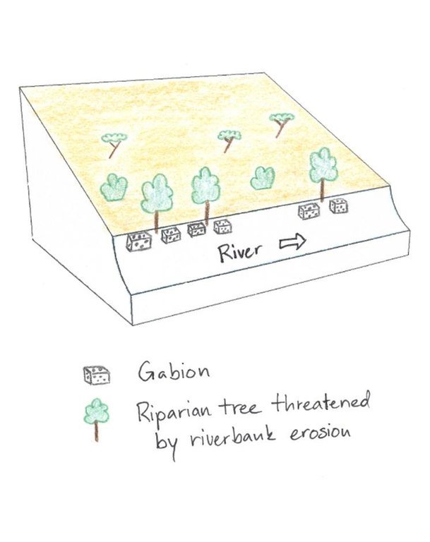
Structural riverbank protection by metal nets called gabion that are filled with stones
The studied land plot is situated in the semi-arid savannah zone of the Naro Moru sub-catchment at the foot of Mt. Kenya. A large-scale farmer owns a spacious land plot bordering Naro Moru River where he grows herbs and special plants to produce human care products. He rarely intervenes in the riparian area but is still interested in a good protection of water resources. Therefore, big stone control structures called gabions were installed to prevent big riparian trees from being undermined by water and destabilized by erosion. This method is cost intensive but can be applied locally for the protection of certain goods. The action was promoted by the Water Resource Users Association of the sub-catchment.
Purpose of the Technology: Despite semi-arid conditions, there is a high probability of flooding. Heavy rainfalls on upper slopes of Mt. Kenya lead to flood events in the semi-arid areas of Naro Moru River. These events have a destructive effect on the riverbanks, which have become instable by human induced activities such as overgrazing and deforestation. The instable riparian soils are eroded easily. The farmers lose their precious land and the water is polluted.
Establishment / maintenance activities and inputs: Big riparian trees are important for stabilizing the riverbed and riverbanks and for building a canopy that provides shade which enables the typical riparian conditions with its vast biodiversity. Thus, large metal nets (2x1x0.5 m) are filled with stones and placed in front of the roots to protect them from the direct current. These metal nets are called gabion and are placed at especially prone places. This structural measure contributes to mitigate or even stop riverbank degradation. High efforts are required to establish gabions. The costs for the metal net amount to 80 US-Dollar per net. Additionally, workforce must be found to fill the nets with stones from the river. Once installed, they ensure a good local protection. They are also used to protect bridge pillars. The life expectance of a gabion net is about 20 years if not destroyed by extreme events.
Natural / human environment: The plot is situated on a plateau at the western side of Mt. Kenya. There is not the same amount of precipitation as at the foot slopes of Mt. Kenya. However, the area still benefits from the runoff that is generated on the mountain. Precipitation in the so-called savannah zone ranges from 600mm to 900mm per year. Due to the high evaporation, rain-fed agriculture is only partly possible. Therefore most land users depend on irrigation using river water.
During the last decades, the region has experienced a still continuing population growth which increases population pressure in the area and removal and use of the vegetation along the rivers. The good accessibility and the moderate tourism allow even off-farm income-generation.
ສະຖານທີ່

ສະຖານທີ່: Nyeri/Naro Moru, Kenya/Central Province, ເຄັນຢາ
ຈໍານວນ ພື້ນທີ່ ທີ່ໃຊ້ ເຕັກໂນໂລຢີ ທີ່ໄດ້ວິເຄາະ:
ການຄັດເລືອກພື້ນທີ່ ທີ່ອີງໃສ່ຂໍ້ມູນທາງພູມີສາດ
ການແຜ່ກະຈາຍຂອງເຕັກໂນໂລຢີ: ແຜ່ຂະຫຍາຍຢ່າງໄວວາໃນພື້ນທີ່ (2.15 km²)
ຢູ່ໃນເຂດປ່າສະຫງວນທີ່ບໍ?:
ວັນທີຂອງການປະຕິບັດ: ຕໍ່າກວ່າ 10 ປີ ຜ່ານມາ (ມາເຖິງປະຈຸບັນ)
ປະເພດຂອງການນໍາສະເໜີ
-
ໂດຍຜ່ານນະວັດຕະກໍາຄິດຄົ້ນຂອງຜູ້ນໍາໃຊ້ທີ່ດິນ
-
ເປັນສ່ວນໜື່ງຂອງລະບົບພື້ນເມືອງ (>50 ປີ)
-
ໃນໄລຍະການທົດລອງ / ການຄົ້ນຄວ້າ
-
ໂດຍຜ່ານໂຄງການ / ການຊ່ວຍເຫຼືອຈາກພາຍນອກ

A metal net filled with stones (gabion) in the bottom right corner for the stabilization of a big riparian tree. (Manuel Fischer)
ຈຸດປະສົງຕົ້ນຕໍ
-
ປັບປຸງ ການຜະລິດ
-
ຫຼຸດຜ່ອນ, ປ້ອງກັນ, ຟື້ນຟູ ການເຊື່ອມໂຊມຂອງດິນ
-
ການອະນຸລັກ ລະບົບນິເວດ
-
ປົກປັກຮັກສານໍ້າ / ນໍ້າພື້ນທີ່ - ປະສົມປະສານກັບ ເຕັກໂນໂລຢີອື່ນໆ
-
ປົກປັກຮັກສາ / ການປັບປຸງຊີວະນາໆພັນ
-
ຫຼຸດຜ່ອນຄວາມສ່ຽງ ທາງໄພພິບັດທໍາມະຊາດ
-
ປັບຕົວຕໍ່ກັບການປ່ຽນແປງດິນຟ້າອາກາດ / ທີ່ຮ້າຍແຮງ ແລະ ຜົນກະທົບ
-
ຫຼຸດຜ່ອນຜົນກະທົບ ຈາກການປ່ຽນແປງດິນຟ້າອາກາດ
-
ສ້າງຜົນກະທົບ ທາງເສດຖະກິດ ທີ່ເປັນປະໂຫຍດ
-
ສ້າງຜົນກະທົບ ທີ່ເປັນທາງບວກ ໃຫ້ແກ່ສັງຄົມ
ການນໍາໃຊ້ດິນ
-
ດິນທີ່ປູກພືດ
- ການປູກພືດປະຈໍາປີ
- ເປັນໄມ້ຢືນຕົ້ນ ແລະ ໄມ້ພຸ່ມ ຈາກການປູກພືດ
ຈໍານວນ ລະດູການ ປູກໃນປີໜຶ່ງ: 2
-
ປ່າໄມ້ / ປ່າ
- (ເຄິ່ງ) ປ່າໄມ້ທໍາມະຊາດ / ປ່າປູກໄມ້. ການຈັດການຄຸ້ມຄອງ: ການນຳໃຊ້ເຄື່ອງປ່າຂອງດົງ
ຜົນຜະລິດ ແລະ ການບໍລິການ: ທົ່ງຫຍ້າ, ການອະນຸລັກທໍາມະຊາດ / ການປ້ອງກັນ
ການສະໜອງນໍ້າ
-
ນໍ້າຝົນ
-
ປະສົມປະສານ ກັນລະຫວ່າງ ນໍ້າຝົນ ແລະ ນໍ້າຊົນລະປະທານ
-
ນໍາໃຊ້ ນໍ້າຊົນລະປະທານ ພຽງຢ່າງດຽວ
ຈຸດປະສົງທີ່ກ່ຽວຂ້ອງກັບການເຊື່ອມໂຊມຂອງດິນ
-
ປ້ອງກັນການເຊື່ອມໂຊມຂອງດິນ
-
ຫຼຸດຜ່ອນການເຊື່ອມໂຊມຂອງດິນ
-
ການຟື້ນຟູ / ຟື້ນຟູດິນທີ່ຊຸດໂຊມ
-
ປັບຕົວຕໍ່ການເຊື່ອມໂຊມຂອງດິນ
-
ບໍ່ສາມາດໃຊ້ໄດ້
ການເຊື່ອມໂຊມ ທີ່ຕ້ອງໄດ້ເອົາໃຈໃສ່
-
ດິນເຊາະເຈື່ອນ ໂດຍນໍ້າ - Wr: ແຄມຕາຝັ່ງເຈື່ອນ
-
ການເຊື່ອມໂຊມ ທາງຊີວະພາບ - Bh: ການສູນເສຍ ທີ່ຢູ່ອາໃສ ຂອງສິ່ງທີ່ມີຊິວິດ, Bs: ຄຸນນະພາບ / ການອັດແໜ້ນ ຂອງສາຍພັນຫຼຸດລົງ
-
ການເຊື່ອມໂຊມ ຂອງນໍ້າ - Hp: ຄຸນນະພາບ ຂອງນ້ຳຊັ້ນໜ້າດິນຫຼຸດລົງ
ກຸ່ມການຄຸ້ມຄອງທີ່ດິນແບບຍືນຍົງ
-
ການຄຸ້ມຄອງນໍ້າໜ້າດິນ (ນ້ຳຈາກພຸ, ແມ່ນໍ້າ, ທະເລສາບ, ທະເລ)
ມາດຕະການ ການຄຸ້ມຄອງທີ່ດິນແບບຍືນຍົງ
-
ມາດຕະການໂຄງສ້າງ - S6: ແລວກັນເຈື່ອນ, ຮົ້ວ
-
ມາດຕະການ ທາງດ້ານການຄຸ້ມຄອງ - M2: ການປ່ຽນແປງ ການຈັດການຄຸ້ມຄອງ / ລະດັບຄວາມໜາແໜ້ນ
ເທັກນິກການແຕ້ມຮູບ
ຂໍກຳນົດທາງເທັກນິກ
In the Savannah zone large riparian trees are threatened, thus gabions are used to protect them and to sustain the canopy. The gabions are applied at the roots of the riparian trees to protect them from the erosive power of the stream.
Location: Irioko. Nyeri / Central Province
Technical knowledge required for field staff / advisors: high
Technical knowledge required for land users: low
Main technical functions: stabilisation of soil (eg by tree roots against land slides), stabilisation of riverbank
Secondary technical functions: sediment retention / trapping, sediment harvesting
Wall/ barrier
Depth of ditches/pits/dams (m): 1
Width of ditches/pits/dams (m): 1
Length of ditches/pits/dams (m): 2
Construction material (stone): Stones are collected directly in the riverbed.
Other type of management: The farmer protected his riparian zone with a fence.
Author: Manuel Fischer
ການຈັດຕັ້ງ ແລະ ບໍາລຸງຮັກສາ: ກິດຈະກໍາ, ວັດຖຸດິບ ແລະ ຄ່າໃຊ້ຈ່າຍ
ການຄຳນວນ ປັດໃຈການຜະລິດ ແລະ ຄ່າໃຊ້ຈ່າຍ
- ຄິດໄລ່ຄ່າໃຊ້ຈ່າຍ: ຕໍ່ຫົວໜ່ວຍ ທີ່ໄດ້ຈັດຕັ້ງປະຕິບັດ ເຕັກໂນໂລຢີ (ຫົວໜ່ວຍ:Gabion volume, length: 2x1x0.5 m)
- ສະກຸນເງິນທີ່ໃຊ້ສໍາລັບການຄິດໄລ່ຄ່າໃຊ້ຈ່າຍ: Kenyan Shilling
- ອັດຕາແລກປ່ຽນ (ເປັນເງີນ ໂດລາ): 1 USD = 90.0 Kenyan Shilling
- ຄ່າແຮງງານສະເລ່ຍ ຂອງການຈ້າງແຮງງານຕໍ່ມື້: 2.70
ປັດໄຈທີ່ສໍາຄັນສຸດທີ່ສົ່ງຜົນກະທົບຕໍ່ຄ່າໃຊ້ຈ່າຍ
The price for the metal wire is the most cost determinant factor.
ກິດຈະກໍາການສ້າງຕັ້ງ
-
Installing and filling the metal wire with stones (ໄລຍະເວລາ / ຄວາມຖີ່: during dry season)
ປັດໄຈນໍາເຂົ້າໃນການຈັດຕັ້ງ ແລະ ຄ່າໃຊ້ຈ່າຍ (per Gabion)
| ລະບຸ ປັດໃຈ ນໍາເຂົ້າ ໃນການຜະລີດ |
ຫົວໜ່ວຍ |
ປະລິມານ |
ຕົ້ນທຶນ ຕໍ່ຫົວໜ່ວຍ (Kenyan Shilling) |
ຕົ້ນທຶນທັງໝົດ ຂອງປັດໃຈຂາເຂົ້າ ໃນການຜະລິດ (Kenyan Shilling) |
% ຂອງຕົ້ນທຶນທັງໝົດ ທີ່ຜູ້ນໍາໃຊ້ທີ່ດິນ ໃຊ້ຈ່າຍເອງ |
|
ແຮງງານ
|
| Installing and filling the metal wire with stones |
Persons/day |
2.0 |
3.0 |
6.0 |
100.0 |
|
ວັດສະດຸກໍ່ສ້າງ
|
| Wire |
piece |
1.0 |
80.0 |
80.0 |
100.0 |
| ຕົ້ນທຶນທັງໝົດ ໃນການຈັດຕັ້ງປະຕິບັດ ເຕັກໂນໂລຢີ |
86.0 |
|
| ຄ່າໃຊ້ຈ່າຍທັງໝົດ ສຳລັບການສ້າງຕັ້ງເຕັກໂນໂລຢີ ເປັນສະກຸນເງີນໂດລາ |
0.96 |
|
ກິດຈະກໍາບໍາລຸງຮັກສາ
-
Control of the gabion nets (ໄລຍະເວລາ / ຄວາມຖີ່: None)
-
Control of fences (ໄລຍະເວລາ / ຄວາມຖີ່: None)
ສະພາບແວດລ້ອມທໍາມະຊາດ
ສະເລ່ຍປະລິມານນໍ້າຝົນປະຈໍາປີ
-
< 250 ມີລິແມັດ
-
251-500 ມີລິແມັດ
-
501-750 ມີລິແມັດ
-
751-1,000 ມີລິແມັດ
-
1,001-1,500 ມີລິແມັດ
-
1,501-2,000 ມີລິແມັດ
-
2,001-3,000 ມີລິແມັດ
-
3,001-4,000 ມີລິແມັດ
-
> 4,000 ມີລິແມັດ
ເຂດກະສິກໍາ-ສະພາບອາກາດ
-
ຄວາມຊຸ່ມ
-
ເຄີ່ງຄວາມຊຸ່ມ
-
ເຄິ່ງແຫ້ງແລ້ງ
-
ແຫ້ງແລ້ງ
ຂໍ້ມູນຈໍາເພາະກ່ຽວກັບສະພາບອາກາດ
Thermal climate class: subtropics
ຄວາມຄ້ອຍຊັນ
-
ພື້ນທີ່ຮາບພຽງ (0-2%)
-
ອ່ອນ (3-5 %)
-
ປານກາງ (6-10 %)
-
ມ້ວນ (11-15 %)
-
ເນີນ(16-30%)
-
ໍຊັນ (31-60%)
-
ຊັນຫຼາຍ (>60%)
ຮູບແບບຂອງດິນ
-
ພູພຽງ / ທົ່ງພຽງ
-
ສັນພູ
-
ເປີ້ນພູ
-
ເນີນພູ
-
ຕີນພູ
-
ຮ່ອມພູ
ລະດັບຄວາມສູງ
-
0-100 ແມັດ a.s.l.
-
101-500 ແມັດ a.s.l.
-
501-1,000 ແມັດ a.s.l.
-
1,001-1,500 ແມັດ a.s.l.
-
1,501-2,000 ແມັດ a.s.l.
-
2,001-2,500 ແມັດ a.s.l.
-
2,501-3,000 ແມັດ a.s.l.
-
3,001-4,000 ແມັດ a.s.l.
-
> 4,000 ແມັດ a.s.l.
ເຕັກໂນໂລຢີໄດ້ຖືກນໍາໃຊ້ໃນ
-
ລັກສະນະສວດ
-
ລັກສະນະກີ່ວ
-
ບໍ່ກ່ຽວຂ້ອງ
ຄວາມເລິກຂອງດິນ
-
ຕື້ນຫຼາຍ (0-20 ຊັງຕີແມັດ)
-
ຕື້ນ (21-50 ຊຕມ)
-
ເລີກປານກາງ (51-80 ຊຕມ)
-
ເລິກ (81-120 ຊມ)
-
ເລິກຫຼາຍ (> 120 cm)
ໂຄງສ້າງຂອງດິນ (ເທີງໜ້າດິນ)
-
ຫຍາບ / ເບົາ (ດິນຊາຍ)
-
ປານກາງ (ດິນໜຽວ, ດິນໂຄນ)
-
ບາງລະອຽດ / ໜັກ (ໜຽວ)
ໂຄງສ້າງຂອງດິນ (ເລິກລົງ 20 ຊັງຕີແມັດ)
-
ຫຍາບ / ເບົາ (ດິນຊາຍ)
-
ປານກາງ (ດິນໜຽວ, ດິນໂຄນ)
-
ບາງລະອຽດ / ໜັກ (ໜຽວ)
ທາດອິນຊີຢູ່ເທິງໜ້າດິນ
-
ສູງ (> 3 %)
-
ປານກາງ (1-3 %)
-
ຕໍາ່ (<1 %)
ນ້ຳໃຕ້ດິນ
-
ເທິງຊັ້ນໜ້າດິນ
-
< 5 ແມັດ
-
5-50 ແມັດ
-
> 50 ແມັດ
ມີນໍ້າໜ້າດິນ
-
ເກີນ
-
ດີ
-
ປານກາງ
-
ທຸກຍາກ / ບໍ່ມີ
ຄຸນນະພາບນໍ້າ (ການຮັກສາ)
-
ມີນໍ້າດື່ມ
-
ບໍ່ມີນໍ້າດື່ມ (ຮຽກຮ້ອງໃຫ້ມີການບຳບັດນ້ຳ)
-
ນຳໃຊ້ເຂົ້າໃນການຜະລິດກະສິກໍາພຽງຢ່າງດຽງ (ຊົນລະປະທານ)
-
ຜິດປົກກະຕິ
ຄຸນນະພາບນ້ຳ ໝາຍເຖີງ:
ດິນເຄັມເປັນບັນຫາບໍ່?
ການເກີດນໍ້າຖ້ວມ
ຄວາມຫຼາກຫຼາຍຂອງສິ່ງທີ່ມີຊີວິດ
ຄຸນລັກສະນະຂອງຜູ້ນຳໃຊ້ທີ່ດິນການນໍາໃຊ້ເຕັກໂນໂລຢີ
ການວາງແນວທາງຕະຫຼາດ
-
ກຸ້ມຕົນເອງ (ພໍພຽງ)
-
ປະສົມປົນເປ( ກຸ້ມຕົນເອງ/ເປັນສິນຄ້າ)
-
ການຄ້າ / ຕະຫຼາດ
ລາຍຮັບທີ່ໄດ້ມາຈາກກິດຈະກໍາອື່ນໆ ທີ່ບໍ່ແມ່ນການຜະລິດກະສິກໍາ
-
ໜ້ອຍກ່ວາ 10 % ຂອງລາຍຮັບທັງໝົດ
-
10-50 % ຂອງລາຍຮັບທັງໝົດ
-
> 50 % ຂອງລາຍຮັບທັງໝົດ
ລະດັບຄວາມຮັ່ງມີ
-
ທຸກຍາກຫຼາຍ
-
ທຸກຍາກ
-
ສະເລ່ຍ
-
ຮັ່ງມີ
-
ຮັ່ງມີຫຼາຍ
ລະດັບຂອງການຫັນເປັນກົນຈັກ
-
ການໃຊ້ແຮງງານຄົນ
-
ສັດລາກແກ່
-
ເຄື່ອງກົນຈັກ
ຢູ່ປະຈຳ ຫຼື ເລລ້ອນ
-
ບໍ່ເຄື່ອນໄຫວ
-
ແບບເຄີ່ງຂັງ-ເຄີ່ງປ່ອຍ
-
ແບບປ່ອຍຕາມທຳມະຊາດ
ບຸກຄົນ ຫຼື ກຸ່ມ
-
ບຸກຄົນ / ຄົວເຮືອນ
-
ກຸ່ມ / ຊຸມຊົນ
-
ການຮ່ວມມື
-
ການຈ້າງງານ (ບໍລິສັດ, ອົງການ ລັດຖະບານ)
ອາຍຸ
-
ເດັກນ້ອຍ
-
ຊາວໜຸ່ມ
-
ໄວກາງຄົນ
-
ຜູ້ສູງອາຍຸ
ເຂດພື້ນທີ່ການນໍາໃຊ້ຕໍ່ຄົວເຮືອນ
-
<0.5 ເຮັກຕາ
-
0.5-1 ເຮັກຕາ
-
1-2 ເຮັກຕາ
-
2-5 ເຮັກຕາ
-
5-15 ເຮັກຕາ
-
15-50 ເຮັກຕາ
-
50-100 ເຮັກຕາ
-
100-500 ເຮັກຕາ
-
500-1,000 ເຮັກຕາ
-
1,000-10,000 ເຮັກຕາ
-
> 10,000 ເຮັກຕາ
ຂະໜາດ
-
ຂະໜາດນ້ອຍ
-
ຂະໜາດກາງ
-
ຂະໜາດໃຫຍ່
ເຈົ້າຂອງທີ່ດິນ
-
ລັດ
-
ບໍລິສັດ
-
ຊຸມຊົນ / ບ້ານ
-
ກຸ່ມ
-
ບຸກຄົນ, ບໍ່ມີຕໍາແໜ່ງ
-
ບຸກຄົນ, ທີ່ມີຕໍາແໜ່ງ
ສິດທິການນໍາໃຊ້ທີ່ດິນ
-
ເປີດກວ້າງ (ບໍ່ມີການຈັດຕັ້ງ)
-
ຊຸມຊົນ (ທີ່ມີການຈັດຕັ້ງ)
-
ເຊົ່າ
-
ບຸກຄົນ
ສິດທິການນໍາໃຊ້ນໍ້າ
-
ເປີດກວ້າງ (ບໍ່ມີການຈັດຕັ້ງ)
-
ຊຸມຊົນ (ທີ່ມີການຈັດຕັ້ງ)
-
ເຊົ່າ
-
ບຸກຄົນ
ການເຂົ້າເຖິງການບໍລິການ ແລະ ພື້ນຖານໂຄງລ່າງ
ການຈ້າງງານ (ຕົວຢ່າງ, ການເຮັດກິດຈະກໍາອື່ນ ທີ່ບໍ່ແມ່ນ ການຜະລິດກະສິກໍາ)
ຖະໜົນຫົນທາງ ແລະ ການຂົນສົ່ງ
ການດື່ມນໍ້າ ແລະ ສຸຂາພິບານ
ການບໍລິການ ທາງດ້ານການເງິນ
ຜົນກະທົບ
ຜົນກະທົບທາງສັງຄົມ ແລະ ເສດຖະກິດ
ເນື້ອທີ່ ການຜະລິດ (ທີ່ດິນໃໝ່ ທີ່ໄດ້ປູກພືດໃສ່ / ນໍາໃຊ້)
ຜົນກະທົບທາງສັງຄົມ ວັດທະນະທໍາ
ສະຖາບັນ ການຈັດຕັ້ງຊຸມຊົນ
This was not mentioned by the interviewee, but seems to be the case
ຄວາມຮູ້ກ່ຽວກັບ ການຄຸ້ມຄອງ ທີ່ດິນແບບຍືນຍົງ / ການເຊື່ອມໂຊມຂອງດິນ
Livelihood and human well-being
The discussions about water conservation increase education. Also, the dialogue between farmers is improved.
ຜົນກະທົບຕໍ່ລະບົບນິເວດ
ຄວາມຫຼາກຫຼາຍ ທາງດ້ານທີ່ຢູ່ອາໃສ ຂອງສິ່ງທີ່ມີຊີວິດ
ຜົນກະທົບນອກສະຖານທີ່
ມີນໍ້າໄຫຼຕະຫຼອດ ໃນລະດູແລ້ງ (ລວມທັງ ມີນໍ້າໄຫຼຄ່ອຍ)
ການທັບຖົມ ຂອງດິນຕະກອນ ຢູ່ເຂດລຸ່ມນໍ້າ
ການວິເຄາະຕົ້ນທຶນ ແລະ ຜົນປະໂຫຍດ
ຜົນປະໂຫຍດເມື່ອທຽບກັບຄ່າໃຊ້ຈ່າຍໃນການສ້າງຕັ້ງ
ຜົນຕອບແທນ ໃນໄລຍະສັ້ນ
ຜົນກະທົບທາງລົບຫຼາຍ
ຜົນກະທົບທາງບວກຫຼາຍ
ຜົນຕອບແທນ ໃນໄລຍະຍາວ
ຜົນກະທົບທາງລົບຫຼາຍ
ຜົນກະທົບທາງບວກຫຼາຍ
ຜົນປະໂຫຍດເມື່ອທຽບກັບຄ່າໃຊ້ຈ່າຍບໍາລຸງຮັກສາ
ຜົນຕອບແທນ ໃນໄລຍະສັ້ນ
ຜົນກະທົບທາງລົບຫຼາຍ
ຜົນກະທົບທາງບວກຫຼາຍ
ຜົນຕອບແທນ ໃນໄລຍະຍາວ
ຜົນກະທົບທາງລົບຫຼາຍ
ຜົນກະທົບທາງບວກຫຼາຍ
ການປ່ຽນແປງສະພາບດິນຟ້າອາກາດ
ການປ່ຽນແປງດິນຟ້າອາກາດ ເທື່ອລະກ້າວ
ອຸນຫະພູມປະຈໍາປີ ເພີ່ມຂື້ນ
ອາກາດ ທີ່ກ່ຽວພັນກັບຄວາມຮຸນແຮງ (ໄພພິບັດທາງທໍາມະຊາດ)
ໂດຍທົ່ວໄປ (ແມ່ນໍ້າ) ນໍ້າຖ້ວມ
ຜົນສະທ້ອນສະພາບອາກາດອື່ນໆທີ່ກ່ຽວຂ້ອງ
ໄລຍະເວລາການຂະຫຍາຍຕົວຫຼຸດລົງ
ການຍອມຮັບ ແລະ ການປັບຕົວ
ອັດຕາສ່ວນຂອງຜູ້ຊົມໃຊ້ທີ່ດິນໃນເຂດພື້ນທີ່ທີ່ໄດ້ຮັບຮອງເອົາເຕັກໂນໂລຢີ
-
ກໍລະນີດຽວ / ການທົດລອງ
-
1-10%
-
11-50%
-
> 50%
ທັງໝົດນັ້ນ ມີໃຜແດ່ທີ່ສາມາດປັບຕົວຕໍ່ເຕັກໂນໂລຢີ, ມີຈັກຄົນທີ່ໄດ້ຮັບການກະຕຸກຊຸກຍູ້ ແລະ ອຸປະກອນ?
-
0-10%
-
11-50%
-
51-90%
-
91-100%
ຈໍານວນຄົວເຮືອນ ແລະ / ຫຼືບໍລິເວນກວມເອົາ
1 landowner
ໄດ້ມີການດັດແປງເຕັກໂນໂລຢີ ເພື່ອປັບໃຫ້ເຂົ້າກັບເງື່ອນໄຂການປ່ຽນແປງບໍ່?
ໄດ້ປ່ຽນແປງເງື່ອນໄຂຫຍັງແດ່?
-
ການປ່ຽນແປງດິນຟ້າອາກາດ / ຮ້າຍແຮງ
-
ຕະຫຼາດມີການປ່ຽນແປງ
-
ມີແຮງງານ (ຕົວຢ່າງ, ເນື່ອງຈາກການເຄື່ອນຍ້າຍແຮງງານ)
ບົດສະຫຼຸບ ແລະ ບົດຮຽນທີ່ໄດ້ຮັບ
ຄວາມເຂັ້ມແຂງ: ທັດສະນະມູມມອງ ຂອງຜູ້ນໍາໃຊ້ທີ່ດິນ
-
Ensuring an intact environment to guarantee the organic origin of the company products.
How can they be sustained / enhanced? Control that the riparian area is not being polluted or destroyed.
ຄວາມເຂັ້ມແຂງ: ທັດສະນະມຸມມອງ ຂອງຜູ້ປ້ອນຂໍ້ມູນເອງ
-
Conservation of the unique riparian habitat
How can they be sustained / enhanced? Continue the protective measures and hinder negative intervention in the riparian area.
-
Through the environmental activities, the acceptance of the company increases.
How can they be sustained / enhanced? Regular interaction improve neighborly relations.
ຈຸດອ່ອນ / ຂໍ້ເສຍ / ຄວາມສ່ຽງ: ທັດສະນະມູມມອງ ຂອງຜູ້ນໍາໃຊ້ທີ່ດິນວິທີການແກ້ໄຂແນວໃດ
ຈຸດອ່ອນ / ຂໍ້ເສຍ / ຄວາມສ່ຽງ: ທັດສະນະມຸມມອງ ຂອງຜູ້ປ້ອນຂໍ້ມູນເອງວິທີການແກ້ໄຂແນວໃດ
-
The implementation of the gabions is very cost-intensive.
Alternatives should be checked out.
-
The origin of the vegetation decline, the decreasing river flow, is not being combatted.
Water abstractions in the upper reaches should be diminished.
ເອກກະສານອ້າງອີງ
ການທົບທວນຄືນ
-
David Streiff
-
Alexandra Gavilano
ວັນທີຂອງການປະຕິບັດ: Sept. 13, 2013
ປັບປຸງລ່າສຸດ: May 7, 2019
ບຸກຄົນທີ່ສໍາຄັນ
-
Manuel Fischer - ຜຸ້ຊ່ຽວຊານ ດ້ານການຄຸ້ມຄອງ ທີ່ດິນແບບຍືນຍົງ
-
John Horsey - Cosmetic company
ການບັນຍາຍລາຍລະອຽດ ໃນຖານຂໍ້ມູນ ຂອງ WOCAT
ຂໍ້ມູນການເຊື່ອມໂຍງຂໍ້ມູນການຄຸ້ມຄອງການນໍາໃຊ້ດິນແບບຍືນຍົງ
ເອກກະສານ ແມ່ນໄດ້ອໍານວຍຄວາມສະດວກໂດຍ
ສະຖາບັນ
- CDE Centre for Development and Environment (CDE Centre for Development and Environment) - ສະວິດເຊີແລນ
- Cinnabar Green Ltd. (CG) - ເຄັນຢາ
ໂຄງການ


