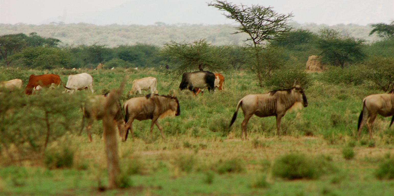
Wildebeest and livestock grazing in the wet season in the grazing area (Guy Western)

Ecosystem-wide seasonal grazing management in community land (ເຄັນຢາ)

ຄຳອະທິບາຍ

Livestock movements are managed through community governance systems to maintain spatial and temporal heterogeneity of pasture, creating a gradient of quality and quantity of pasture across the landscape. This is achieved through clearly designated seasonal grazing areas for livestock and tight controls on settlement areas, grazing patterns and water points. In addition, at the individual herder level, traditional ecological knowledge plays a strong role in the decisions made to improve livestock production

This technology is applied in the South Rift Valley, Kenya, across a semi-arid landscape, with erratic rainfall averaging 400-600 mm per annum. Water availability is an issue. The perennial Ewaso Ngiro South river flows through the Shompole swamp, a vital drought refuge for livestock and wildlife, before ending up in Lake Natron. The area, roughly 1000 km2, is covered by two group ranches, Olkiramatian and Shompole, which are managed as a single ecological unit. A group ranch is a jointly owned freehold land title given to the customary occupants of communal lands. The total number of occupants of both ranches number roughly 20,000 people, with the majority belonging to the Maasai ethnic group. The ranches have not been subdivided and are not fully sedentary, unlike many other areas of southern Kenya.
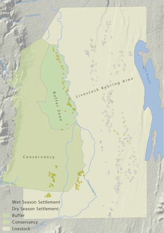
There is a long history of co-existence of wildlife and livestock in Maasialand. In Olkiramatian and Shompole seasonal livestock movements and herding practices are formalized by group ranch grazing plans governed by local committees. The wet season grazing areas are termed “livestock rearing zones”. The dry season grazing areas have been retained as “grass banks” for livestock, and since the early 2000s, have been used additionally as wildlife conservancies for ecotourism (see figure below). Livestock rearing occurs to the east of the Ewaso Ngiro river; grass banks and the wildlife conservancy to the west. Grazing committees from both group ranches manage livestock access to certain areas, with the conservancy (grass bank) rested during the wet season of up to six months. When grazing is permitted in the conservancy, as the dry season progresses, temporary settlements are limited to an area called the “buffer zone”. Livestock must then move into the conservancy from the buffer zones to access this late season grazing. The “livestock rearing zone” is permanently settled and grazed year-round. Within each zone there are small “Olopololis” (grass banks of a few hectares), situated near individual settlements and used to maintain higher quality pasture for weak and young animals. This management strategy ensures that the dry season grazing area is rested during the rains, and it helps to maintain consistently higher biomass and taller grass than that of the wet season grazing area. The higher biomass also corresponds to a rainfall gradient running from the Nguruman Escarpment edge in the western extremity of the group ranches to the dry central rift valley floor in the east. The biomass in the dry season area is used by both livestock and wildlife grazers during the late dry season and in droughts. The grass bank is only grazed out during prolonged dry periods. The Maasai employ a strategy of using the shorter milk-producing grasses of the livestock areas during the rains and the coarser grasses in the grass banks for the dry seasons. The shorter wet season pastures have a higher nutrient content and greater digestibility than the grass bank: this is very important for lactating females. The grass is kept short from both grazing by livestock during the growing seasons and due to intrinsic differences caused by shallower soils and lower rainfall in these grazing areas.
Within this broader governance framework and control of grazing areas, individual decision making is also permitted within these controlled areas. This allows herders to manage livestock to improve production in relation to each herd. For example, individuals might split the herd to take advantage of different energy and nutrient requirements of lactating females, bulls, and calves.
This maintenance and exploitation of forage heterogeneity is vital to the productivity and resilience of the landscape, and this heterogeneity exists at multiple scales, with the major differences existing between the grazing areas, but also smaller difference within them. Resource heterogeneity facilitates wildlife-livestock coexistence. This heterogeneity creates a matrix of varying quality and quantity of forage. Wildlife species have different metabolic requirements and diets, and this varied base ensures that a diverse wild ungulate population is maintained year-round. Late season forage boosts the resilience of wildlife during extreme events. This technology requires a governance structure that is both responsive to the changing ecological conditions and able to build consensus and enforce grazing management.
ສະຖານທີ່

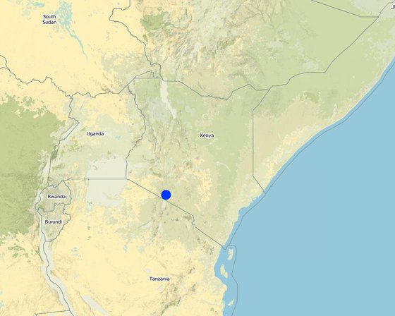
ສະຖານທີ່: Olkiramatian, Kajiado, ເຄັນຢາ

ຈໍານວນ ພື້ນທີ່ ທີ່ໃຊ້ ເຕັກໂນໂລຢີ ທີ່ໄດ້ວິເຄາະ: ພື້ນທີ່ດຽວ

ການຄັດເລືອກພື້ນທີ່ ທີ່ອີງໃສ່ຂໍ້ມູນທາງພູມີສາດ
  • 36.14942, -1.86005

ການແຜ່ກະຈາຍຂອງເຕັກໂນໂລຢີ: ແຜ່ຂະຫຍາຍຢ່າງໄວວາໃນພື້ນທີ່ (approx. 100-1,000 ກມ 2)

ຢູ່ໃນເຂດປ່າສະຫງວນທີ່ບໍ?:

ວັນທີຂອງການປະຕິບັດ: 2004

ປະເພດຂອງການນໍາສະເໜີ

ການໄຈ້ແຍກເຕັກໂນໂລຢີ

ຈຸດປະສົງຕົ້ນຕໍ
  • ປັບປຸງ ການຜະລິດ
  • ຫຼຸດຜ່ອນ, ປ້ອງກັນ, ຟື້ນຟູ ການເຊື່ອມໂຊມຂອງດິນ
  • ການອະນຸລັກ ລະບົບນິເວດ
  • ປົກປັກຮັກສານໍ້າ / ນໍ້າພື້ນທີ່ - ປະສົມປະສານກັບ ເຕັກໂນໂລຢີອື່ນໆ
  • ປົກປັກຮັກສາ / ການປັບປຸງຊີວະນາໆພັນ
  • ຫຼຸດຜ່ອນຄວາມສ່ຽງ ທາງໄພພິບັດທໍາມະຊາດ
  • ປັບຕົວຕໍ່ກັບການປ່ຽນແປງດິນຟ້າອາກາດ / ທີ່ຮ້າຍແຮງ ແລະ ຜົນກະທົບ
  • ຫຼຸດຜ່ອນຜົນກະທົບ ຈາກການປ່ຽນແປງດິນຟ້າອາກາດ
  • ສ້າງຜົນກະທົບ ທາງເສດຖະກິດ ທີ່ເປັນປະໂຫຍດ
  • ສ້າງຜົນກະທົບ ທີ່ເປັນທາງບວກ ໃຫ້ແກ່ສັງຄົມ
ການນໍາໃຊ້ດິນ

  • ທົ່ງຫຍ້າລ້ຽງສັດ
    • ການລ້ຽງສັດແບບເຄີ່ງປ່ອຍ
    ປະເພດສັດ: ແບ້, ແກະ, cattle
ການສະໜອງນໍ້າ
  • ນໍ້າຝົນ
  • ປະສົມປະສານ ກັນລະຫວ່າງ ນໍ້າຝົນ ແລະ ນໍ້າຊົນລະປະທານ
  • ນໍາໃຊ້ ນໍ້າຊົນລະປະທານ ພຽງຢ່າງດຽວ

ຈຸດປະສົງທີ່ກ່ຽວຂ້ອງກັບການເຊື່ອມໂຊມຂອງດິນ
  • ປ້ອງກັນການເຊື່ອມໂຊມຂອງດິນ
  • ຫຼຸດຜ່ອນການເຊື່ອມໂຊມຂອງດິນ
  • ການຟື້ນຟູ / ຟື້ນຟູດິນທີ່ຊຸດໂຊມ
  • ປັບຕົວຕໍ່ການເຊື່ອມໂຊມຂອງດິນ
  • ບໍ່ສາມາດໃຊ້ໄດ້
ການເຊື່ອມໂຊມ ທີ່ຕ້ອງໄດ້ເອົາໃຈໃສ່
  • ດິນເຊາະເຈື່ອນ ໂດຍນໍ້າ - Wt: ການສູນເສຍຊັ້ນໜ້າດິນ / ການເຊາະເຈື່ອນຜິວໜ້າດິນ
  • ການເຊື່ອມໂຊມ ທາງຊີວະພາບ - Bc: ການຫຼຸດຜ່ອນການປົກຫຸ້ມຂອງພືດ, Bh: ການສູນເສຍ ທີ່ຢູ່ອາໃສ ຂອງສິ່ງທີ່ມີຊິວິດ, Bq: ປະລິມານ / ອິນຊີວັດຖຸຫຼຸດລົງ, Bs: ຄຸນນະພາບ / ການອັດແໜ້ນ ຂອງສາຍພັນຫຼຸດລົງ
ກຸ່ມການຄຸ້ມຄອງທີ່ດິນແບບຍືນຍົງ
  • ການຄຸ້ມຄອງສັດລ້ຽງ ແລະ ທົ່ງຫຍ້າລ້ຽງສັດ
ມາດຕະການ ການຄຸ້ມຄອງທີ່ດິນແບບຍືນຍົງ
  • ມາດຕະການ ທາງດ້ານການຄຸ້ມຄອງ - M2: ການປ່ຽນແປງ ການຈັດການຄຸ້ມຄອງ / ລະດັບຄວາມໜາແໜ້ນ, M3: ອີງຕາມສະພາບແວດລ້ອມ ທາງທຳມະຊາດ ແລະ ມະນຸດ, M4: ການປ່ຽນແປງ ໄລຍະເວລາ ໃນການຈັດຕັ້ງປະຕິບັດ ກິດຈະກໍາ

​ເທັກ​ນິກ​ການ​ແຕ້ມ​ຮ​ູບ

​ຂໍ​ກຳ​ນົດ​ທາງ​ເທັກ​ນິກ
The drawing shows the management units used in this seasonally structured grazing management system. The livestock rearing zone, to the east of the Ewaso Nyiro river, is permanently settled and is grazed heavily during the wet season (April - July). During this time herders utilize the short, nutritious grasses in this low biomass area. As forage biomass begins to reduce the community grazing committees meet to discuss the opening of settlements to the west of the Ewaso Nyiro river. This decision is made using traditional ecological knowledge, comparing available forage biomass and the numbers of livestock to previous years and past experiences. Once the grazing has been opened to the west of the river people may settle within the buffer zone. This limits direct access to the higher biomass areas within the conservancy and grass banks, and increases the length of travel for each herd every day, in an effort to preserve forage for longer. Once forage has been depleted in the buffer zones and the periphery of the conservancies, the committees meet and allow access for herders into the conservation areas, which have tall, high biomass, but low-quality grazing. Often access to this area requires considerable distances to be walked by livestock. In recent years, adaptive management systems have led to the settlements within the south of the conservation area to be closed to preserve forage biomass within the swamp and conservation area for a longer period of time; and allow for recovery of partially degraded land.
Author: Peter Tyrrell

ການຈັດຕັ້ງ ແລະ ບໍາລຸງຮັກສາ: ກິດຈະກໍາ, ວັດຖຸດິບ ແລະ ຄ່າໃຊ້ຈ່າຍ

ການ​ຄຳ​ນວນ​ ປັດ​ໃຈ​ການ​ຜະ​ລິດ ແລະ ຄ່າ​ໃຊ້​ຈ່າຍ
  • ຄິດໄລ່ຄ່າໃຊ້ຈ່າຍ: ຕໍ່ຫົວໜ່ວຍ ທີ່ໄດ້ຈັດຕັ້ງປະຕິບັດ ເຕັກໂນໂລຢີ (ຫົວໜ່ວຍ:The two group ranches volume, length: Approximately 1000km2)
  • ສະກຸນເງິນທີ່ໃຊ້ສໍາລັບການຄິດໄລ່ຄ່າໃຊ້ຈ່າຍ: USA
  • ອັດຕາແລກປ່ຽນ (ເປັນເງີນ ໂດລາ): 1 USD = ບໍ່ມີຂໍ້ມູນ
  • ຄ່າແຮງງານສະເລ່ຍ ຂອງການຈ້າງແຮງງານຕໍ່ມື້: 4
ປັດໄຈທີ່ສໍາຄັນສຸດທີ່​ສົ່ງຜົນກະທົບຕໍ່ຄ່າໃຊ້ຈ່າຍ
There are no or little costs to this technology, as it builds off structures of management which are already in place and work organically within the area.
ກິດຈະກໍາການສ້າງຕັ້ງ
n.a.
ກິດຈະກໍາບໍາລຸງຮັກສາ
  1. Management meetings (ໄລຍະເວລາ / ຄວາມຖີ່: Seasonally)

ສະພາບແວດລ້ອມທໍາມະຊາດ

ສະເລ່ຍປະລິມານນໍ້າຝົນປະຈໍາປີ
  • < 250 ມີລິແມັດ
  • 251-500 ມີລິແມັດ
  • 501-750 ມີລິແມັດ
  • 751-1,000 ມີລິແມັດ
  • 1,001-1,500 ມີລິແມັດ
  • 1,501-2,000 ມີລິແມັດ
  • 2,001-3,000 ມີລິແມັດ
  • 3,001-4,000 ມີລິແມັດ
  • > 4,000 ມີລິແມັດ
ເຂດກະສິກໍາ-ສະພາບອາກາດ
  • ຄວາມຊຸ່ມ
  • ເຄີ່ງຄວາມຊຸ່ມ
  • ເຄິ່ງແຫ້ງແລ້ງ
  • ແຫ້ງແລ້ງ
ຂໍ້ມູນຈໍາເພາະກ່ຽວກັບສະພາບອາກາດ
ປະລິມານນໍ້າຝົນສະເລ່ຍຕໍ່ປີເປັນມິລິແມັດ: 400.0
Highly variable rainfall both spatially and temporally. Annual average rainfall has a 33%CV.
ຊື່ຂອງສະຖານີອຸຕຸນິຍົມ: Lale'enok Resource Centre
​ຄວາມຄ້ອຍ​ຊັນ
  • ພື້ນທີ່ຮາບພຽງ (0-2%)
  • ອ່ອນ (3-5 %)
  • ປານກາງ (6-10 %)
  • ມ້ວນ (11-15 %)
  • ເນີນ(16-30%)
  • ໍຊັນ (31-60%)
  • ຊັນຫຼາຍ (>60%)
ຮູບແບບຂອງດິນ
  • ພູພຽງ / ທົ່ງພຽງ
  • ສັນພູ
  • ເປີ້ນພູ
  • ເນີນພູ
  • ຕີນພູ
  • ຮ່ອມພູ
ລະດັບຄວາມສູງ
  • 0-100 ແມັດ a.s.l.
  • 101-500 ແມັດ a.s.l.
  • 501-1,000 ແມັດ a.s.l.
  • 1,001-1,500 ແມັດ a.s.l.
  • 1,501-2,000 ແມັດ a.s.l.
  • 2,001-2,500 ແມັດ a.s.l.
  • 2,501-3,000 ແມັດ a.s.l.
  • 3,001-4,000 ແມັດ a.s.l.
  • > 4,000 ແມັດ a.s.l.
ເຕັກໂນໂລຢີໄດ້ຖືກນໍາໃຊ້ໃນ
  • ລັກສະນະສວດ
  • ລັກສະນະກີ່ວ
  • ບໍ່ກ່ຽວຂ້ອງ
ຄວາມເລິກຂອງດິນ
  • ຕື້ນຫຼາຍ (0-20 ຊັງຕີແມັດ)
  • ຕື້ນ (21-50 ຊຕມ)
  • ເລີກປານກາງ (51-80 ຊຕມ)
  • ເລິກ (81-120 ຊມ)
  • ເລິກຫຼາຍ (> 120 cm)
ໂຄງສ້າງຂອງດິນ (ເທີງໜ້າດິນ)
  • ຫຍາບ / ເບົາ (ດິນຊາຍ)
  • ປານກາງ (ດິນໜຽວ, ດິນໂຄນ)
  • ບາງລະອຽດ / ໜັກ (ໜຽວ)
ໂຄງສ້າງຂອງດິນ (ເລິກລົງ 20 ຊັງຕີແມັດ)
  • ຫຍາບ / ເບົາ (ດິນຊາຍ)
  • ປານກາງ (ດິນໜຽວ, ດິນໂຄນ)
  • ບາງລະອຽດ / ໜັກ (ໜຽວ)
ທາດອິນຊີຢູ່ເທິງໜ້າດິນ
  • ສູງ (> 3 %)
  • ປານກາງ (1-3 %)
  • ຕໍາ່ (<1 %)
​ນ້ຳ​ໃຕ້​ດິນ
  • ເທິງຊັ້ນໜ້າດິນ
  • < 5 ແມັດ
  • 5-50 ແມັດ
  • > 50 ແມັດ
ມີນໍ້າໜ້າດິນ
  • ເກີນ
  • ດີ
  • ປານກາງ
  • ທຸກຍາກ / ບໍ່ມີ
ຄຸນນະພາບນໍ້າ (ການຮັກສາ)
  • ມີນໍ້າດື່ມ
  • ບໍ່ມີນໍ້າດື່ມ (ຮຽກຮ້ອງໃຫ້ມີການບຳບັດນ້ຳ)
  • ນຳໃຊ້ເຂົ້າໃນການຜະລິດກະສິກໍາພຽງຢ່າງດຽງ (ຊົນລະປະທານ)
  • ຜິດປົກກະຕິ
ຄຸນນະພາບນ້ຳ ໝາຍເຖີງ:
ດິນ​ເຄັມ​ເປັນ​ບັນ​ຫາ​ບໍ່?
  • ແມ່ນ
  • ບໍ່ແມ່ນ

ການເກີດນໍ້າຖ້ວມ
  • ແມ່ນ
  • ບໍ່ແມ່ນ
ຄວາມຫຼາກຫຼາຍຂອງຊະນິດ
  • ສູງ
  • ປານກາງ
  • ຕໍ່າ
ຄວາມຫຼາກຫຼາຍຂອງສິ່ງທີ່ມີຊີວິດ
  • ສູງ
  • ປານກາງ
  • ຕໍ່າ

ຄຸນລັກສະນະຂອງຜູ້ນຳໃຊ້ທີ່ດິນການນໍາໃຊ້ເຕັກໂນໂລຢີ

ການວາງແນວທາງຕະຫຼາດ
  • ກຸ້ມຕົນເອງ (ພໍພຽງ)
  • ປະສົມປົນເປ( ກຸ້ມຕົນເອງ/ເປັນສິນຄ້າ)
  • ການຄ້າ / ຕະຫຼາດ
ລາຍຮັບທີ່ໄດ້ມາຈາກກິດຈະກໍາອື່ນໆ ທີ່ບໍ່ແມ່ນການຜະລິດກະສິກໍາ
  • ໜ້ອຍກ່ວາ 10 % ຂອງລາຍຮັບທັງໝົດ
  • 10-50 % ຂອງລາຍຮັບທັງໝົດ
  • > 50 % ຂອງລາຍຮັບທັງໝົດ
ລະດັບຄວາມຮັ່ງມີ
  • ທຸກ​ຍາກ​ຫຼາຍ
  • ທຸກຍາກ
  • ສະເລ່ຍ
  • ຮັ່ງມີ
  • ຮັ່ງມີຫຼາຍ
ລະດັບຂອງການຫັນເປັນກົນຈັກ
  • ການໃຊ້ແຮງງານຄົນ
  • ສັດລາກແກ່
  • ເຄື່ອງກົນຈັກ
ຢູ່​ປະ​ຈຳ ຫຼື ເລ​ລ້ອນ
  • ບໍ່ເຄື່ອນໄຫວ
  • ແບບເຄີ່ງຂັງ-ເຄີ່ງປ່ອຍ
  • ແບບປ່ອຍຕາມທຳມະຊາດ
ບຸກຄົນ ຫຼື ກຸ່ມ
  • ບຸກຄົນ / ຄົວເຮືອນ
  • ກຸ່ມ / ຊຸມຊົນ
  • ການຮ່ວມມື
  • ການຈ້າງງານ (ບໍລິສັດ, ອົງການ ລັດຖະບານ)
ເພດ
  • ຜູ້ຍິງ
  • ຜູ້ຊາຍ
ອາ​ຍຸ
  • ເດັກນ້ອຍ
  • ຊາວໜຸ່ມ
  • ໄວ​ກາງ​ຄົນ
  • ຜູ້ສູງອາຍຸ
ເຂດພື້ນທີ່ການນໍາໃຊ້ຕໍ່ຄົວເຮືອນ
  • <0.5 ເຮັກຕາ
  • 0.5-1 ເຮັກຕາ
  • 1-2 ເຮັກຕາ
  • 2-5 ເຮັກຕາ
  • 5-15 ເຮັກຕາ
  • 15-50 ເຮັກຕາ
  • 50-100 ເຮັກຕາ
  • 100-500 ເຮັກຕາ
  • 500-1,000 ເຮັກຕາ
  • 1,000-10,000 ເຮັກຕາ
  • > 10,000 ເຮັກຕາ
ຂະໜາດ
  • ຂະໜາດນ້ອຍ
  • ຂະໜາດກາງ
  • ຂະໜາດໃຫຍ່
ເຈົ້າຂອງທີ່ດິນ
  • ລັດ
  • ບໍລິສັດ
  • ຊຸມຊົນ / ບ້ານ
  • ກຸ່ມ
  • ບຸກຄົນ, ບໍ່ມີຕໍາແໜ່ງ
  • ບຸກຄົນ, ທີ່ມີຕໍາແໜ່ງ
ສິດທິການນໍາໃຊ້ທີ່ດິນ
  • ເປີດກວ້າງ (ບໍ່ມີການຈັດຕັ້ງ)
  • ຊຸມຊົນ (ທີ່ມີການຈັດຕັ້ງ)
  • ເຊົ່າ
  • ບຸກຄົນ
ສິດທິການນໍາໃຊ້ນໍ້າ
  • ເປີດກວ້າງ (ບໍ່ມີການຈັດຕັ້ງ)
  • ຊຸມຊົນ (ທີ່ມີການຈັດຕັ້ງ)
  • ເຊົ່າ
  • ບຸກຄົນ
  • Traditional methods of water management through comittees exists in some areas. In other area the creation of Water Resource Users Associations has begun to manage water.
ການເຂົ້າເຖິງການບໍລິການ ແລະ ພື້ນຖານໂຄງລ່າງ
ສຸຂະພາບ

ທຸກຍາກ
x
ດີ
ການສຶກສາ

ທຸກຍາກ
x
ດີ
ການຊ່ວຍເຫຼືອ ດ້ານວິຊາການ

ທຸກຍາກ
x
ດີ
ການຈ້າງງານ (ຕົວຢ່າງ, ການເຮັດກິດຈະກໍາອື່ນ ທີ່ບໍ່ແມ່ນ ການຜະລິດກະສິກໍາ)

ທຸກຍາກ
x
ດີ
ຕະຫຼາດ

ທຸກຍາກ
x
ດີ
ພະລັງງານ

ທຸກຍາກ
x
ດີ
ຖະໜົນຫົນທາງ ແລະ ການຂົນສົ່ງ

ທຸກຍາກ
x
ດີ
ການດື່ມນໍ້າ ແລະ ສຸຂາພິບານ

ທຸກຍາກ
x
ດີ
ການ​ບໍ​ລິ​ການ​ ທາງ​ດ້ານ​ການ​ເງິນ

ທຸກຍາກ
x
ດີ

ຜົນກະທົບ

ຜົນກະທົບທາງສັງຄົມ ແລະ ເສດຖະກິດ
ການຜະລິດອາຫານສັດ
ຫຼຸດລົງ
x
ເພີ່ມຂຶ້ນ


This is in contrast to areas without seasonal grazing management.

ຄຸນນະພາບຂອງອາຫານສັດ
ຫຼຸດລົງ
x
ເພີ່ມຂຶ້ນ


This management system works best to preserve lower quality higher biomass fodder. Quality may not increase dramatically, but the creation of short areas of well-fertilized grass near settlements may increase the local quality of fodder during the wet season.

ຄວາມສ່ຽງ ຕໍ່ຜົນຜະລິດ
ເພີ່ມຂຶ້ນ
x
ຫຼຸດລົງ


In comparison to other systems the preservation of late season grazing is crucial in preventing complete losses of livestock during droughts.

ຜົນກະທົບທາງສັງຄົມ ວັດທະນະທໍາ
ໂອກາດ ທາງດ້ານວັດທະນະທໍາ (ຕົວຢ່າງ, ກ່ຽວກັບ ວິນຍານ, ສິລະປະ ແລະ ອື່ນໆ)
ຫຼຸດຜ່ອນ
x
ປັບປຸງ


Management of land in this manner relies on traditional ecological knowledge for both individual and community decision making. This is dependent on cultural values and understanding, and underpins grazing management in Maasai society.

ຜົນກະທົບຕໍ່ລະບົບນິເວດ
ການປົກຫຸ້ມຂອງພືດ
ຫຼຸດລົງ
x
ເພີ່ມຂຶ້ນ


This method increase vegetation cover by maintaining heterogeneity of forage resources across the landscape, and resting pasture seasonally to allow for vegetation regrowth.

ມວນຊີວະພາບ / ຢູ່ເທິງຊັ້ນດິນ C
ຫຼຸດລົງ
x
ເພີ່ມຂຶ້ນ


Late season forage available. Recovery and rest allows for greater productivity and rainfall use efficiency.

ຄວາມຫຼາກຫຼາຍຂອງສັດ
ຫຼຸດລົງ
x
ເພີ່ມຂຶ້ນ


Maintenance of spatial and temporal heterogeneity of forage resources ensures that wildlife species have access to the variable resources that they require over time.

ຜົນກະທົບນອກ​ສະ​ຖານ​ທີ່

ການວິເຄາະຕົ້ນທຶນ ແລະ ຜົນປະໂຫຍດ

ຜົນປະໂຫຍດເມື່ອທຽບກັບຄ່າໃຊ້ຈ່າຍໃນການສ້າງຕັ້ງ
ຜົນຕອບແທນ ໃນໄລຍະສັ້ນ
ຜົນກະທົບທາງລົບຫຼາຍ
x
ຜົນກະທົບທາງບວກຫຼາຍ

ຜົນຕອບແທນ ໃນໄລຍະຍາວ
ຜົນກະທົບທາງລົບຫຼາຍ
x
ຜົນກະທົບທາງບວກຫຼາຍ

ຜົນປະໂຫຍດເມື່ອທຽບກັບຄ່າໃຊ້ຈ່າຍບໍາລຸງຮັກສາ
ຜົນຕອບແທນ ໃນໄລຍະສັ້ນ
ຜົນກະທົບທາງລົບຫຼາຍ
x
ຜົນກະທົບທາງບວກຫຼາຍ

ຜົນຕອບແທນ ໃນໄລຍະຍາວ
ຜົນກະທົບທາງລົບຫຼາຍ
x
ຜົນກະທົບທາງບວກຫຼາຍ

No costs to establish and low direct cost of management actions.

ການປ່ຽນແປງສະພາບດິນຟ້າອາກາດ

ການປ່ຽນແປງດິນຟ້າອາກາດ ເທື່ອລະກ້າວ
ປະລິມານນໍ້າຝົນປະຈໍາປີ ຫຼຸດລົງ

ບໍ່ດີຈັກຢ່າງ
x
ດີຫຼາຍ
ປະລິມານນໍ້າຝົນຕາມລະດູການ ຫຼຸດລົງ

ບໍ່ດີຈັກຢ່າງ
x
ດີຫຼາຍ
ລະດູການ: ຄວາມຊຸ່ມ / ລະດູຝົນ
ອາກາດ ທີ່ກ່ຽວພັນກັບຄວາມຮຸນແຮງ (ໄພພິບັດທາງທໍາມະຊາດ)
ແຫ້ງແລ້ງ

ບໍ່ດີຈັກຢ່າງ
x
ດີຫຼາຍ

ການຍອມຮັບ ແລະ ການປັບຕົວ

ອັດຕາສ່ວນຂອງຜູ້ຊົມໃຊ້ທີ່ດິນໃນເຂດພື້ນທີ່ທີ່ໄດ້ຮັບຮອງເອົາເຕັກໂນໂລຢີ
  • ກໍລະນີດຽວ / ການທົດລອງ
  • 1-10%
  • 11-50%
  • > 50%
ທັງໝົດນັ້ນ ມີໃຜແດ່ທີ່ສາມາດປັບຕົວຕໍ່ເຕັກໂນໂລຢີ,​ ມີຈັກຄົນທີ່ໄດ້ຮັບການກະຕຸກຊຸກຍູ້ ແລະ ອຸປະກອນ?
  • 0-10%
  • 11-50%
  • 51-90%
  • 91-100%
ໄດ້ມີການດັດແປງເຕັກໂນໂລຢີ ເພື່ອປັບໃຫ້ເຂົ້າກັບເງື່ອນໄຂການປ່ຽນແປງບໍ່?
  • ແມ່ນ
  • ບໍ່ແມ່ນ
ໄດ້ປ່ຽນແປງເງື່ອນໄຂຫຍັງແດ່?
  • ການປ່ຽນແປງດິນຟ້າອາກາດ / ຮ້າຍແຮງ
  • ຕະຫຼາດມີການປ່ຽນແປງ
  • ມີແຮງງານ (ຕົວຢ່າງ, ເນື່ອງຈາກການເຄື່ອນຍ້າຍແຮງງານ)
The management is constantly being adapted based on the prevailing ecological conditions. In 2015, over fifty settlements were closed by the community grazing and group ranch committee within the dry season grazing area to allow for pasture regeneration and to consolidate preservation of the dry season grass bank.

ບົດສະຫຼຸບ ແລະ ບົດຮຽນທີ່ໄດ້ຮັບ

ຄວາມເຂັ້ມແຂງ: ທັດສະນະມູມມອງ ຂອງຜູ້ນໍາໃຊ້ທີ່ດິນ
  • This technology stems from a community based and is not imposed from a top-down perspective, and tries to create consensus among resource users.
  • Allows individual flexibility within the broader grazing structure so that people can manage livestock within their own objectives.
  • This technology provides forage for livestock into the dry season and drought.
ຄວາມເຂັ້ມແຂງ: ທັດສະນະມຸມມອງ ຂອງຜູ້ປ້ອນຂໍ້ມູນເອງ
  • Management in this way also replicates the methodologies used for land management for thousands of years by pastoral people and helps to generate an enabling environment for the coexistence of wildlife, domestic livestock, and people.
  • Ensures that pasture is rested during the growing season within the dry season grazing areas, so that root mass can be established and to ensure grass seed production.
ຈຸດອ່ອນ / ຂໍ້ເສຍ / ຄວາມສ່ຽງ: ທັດສະນະມູມມອງ ຂອງຜູ້ນໍາໃຊ້ທີ່ດິນວິທີການແກ້ໄຂແນວໃດ
  • Exploitation of the system by elites in charge of management decisions, allowing their livestock to access preferential grazing, which may not represent the needs of all groups. Ensure credible management structures in place; with the new community land act, this should encourage greater equity in decision making.
  • Preventing settlement in areas of traditional occupation by certain households.
ຈຸດອ່ອນ / ຂໍ້ເສຍ / ຄວາມສ່ຽງ: ທັດສະນະມຸມມອງ ຂອງຜູ້ປ້ອນຂໍ້ມູນເອງວິທີການແກ້ໄຂແນວໃດ
  • Lack of focus on a production based system and income generation through livestock sales. Create and enabling environment for change, through market improvement and learning exchanges.
  • Lack of resting and recovery of forage in the wet season grazing area. Rotate and rest wet season pasture for a few weeks during the growing period, potentially through grazing in the dry season reserve for a longer period.

ເອກກະສານອ້າງອີງ

ການລວບລວມ
  • Peter Tyrrell
Editors
  • Enoch Mobisa
  • Lance W. Robinson
ການທົບທວນຄືນ
  • Donia Mühlematter
  • Hanspeter Liniger
  • Rima Mekdaschi Studer
  • Alexandra Gavilano
ວັນທີຂອງການປະຕິບັດ: Feb. 1, 2018
ປັບປຸງລ່າສຸດ: June 7, 2019
ບຸກຄົນທີ່ສໍາຄັນ
ການບັນຍາຍລາຍລະອຽດ ໃນຖານຂໍ້ມູນ ຂອງ WOCAT
ຂໍ້ມູນການເຊື່ອມໂຍງຂໍ້ມູນການຄຸ້ມຄອງການນໍາໃຊ້ດິນແບບຍືນຍົງ
ເອກກະສານ ແມ່ນໄດ້ອໍານວຍຄວາມສະດວກໂດຍ
ສະຖາບັນ ​ໂຄງ​ການ
ເຊື່ອມໂຍງກັບ ຂໍ້ມູນຕ່າງໆ ທີ່ກ່ຽວຂ້ອງທີ່ມີ
This work is licensed under Creative Commons Attribution-NonCommercial-ShareaAlike 4.0 International