Sustainable land management using controlled gullying
(ເນໂປ)
Jagidol chetra ma kholsi sudhar dwara digo bhu bewasthapan (Main Contributor: Sabita Khanal, Kathmandu University)
ຄຳອະທິບາຍ
An indigenous technology to help control channelled water during the rainy season and conserve it during the dry season
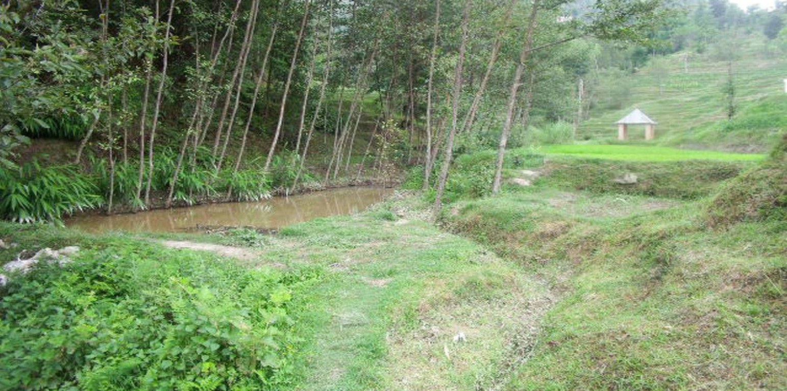
For more than two centuries, local farmers have promoted soil and water conservation by protecting the gullies which occur naturally between rice terraces; thus the land area is called ‘jagidol’ (jagi=rice, dol=gully). The small perennial streams which flow through the terraces are protected by constructing check dams and retaining walls to reduce the danger of erosion and collapse.
Purpose of the Technology: During the monsoon, the channels or trenches can become engorged and, since their walls are not reinforced (except for grass planted at the edges), the conduits can be easily eroded. When the erosion is severe enough, the edges of the terraces adjacent to the gullies can collapse. When many gullies collapse at once, the stability of the entire hillside is threatened with catastrophic consequences for the village situated above the planting area. Villagers have traditionally used local materials and expertise to maintain the gullies and reduce soil erosion by building retaining walls across the slope which are strengthened through plantation. The retaining walls are bio-engineered using a combination of bamboo poles, rocks, and soil-filled sacks. Bamboo poles are used for the backbone of the support structure, and rocks and soil-filled sacks are used to line the sides of the channel. Local grasses such as 'sitto' are planted on the top and, as they grow, their roots help to anchor the structure. When the channels are fortified by retaining walls and planting, they become entrenched and, over time, less maintenance is required. As a bonus, when the plants grown along the gullies mature, they provide biomass for the farm and fodder for cattle. During winter, when water is scarce, farmers modify the gully system by constructing check dams which can be used to collect water in one place. These dams are useful for irrigation during the dry season and they also help to prevent bed scouring.
ສະຖານທີ່
ສະຖານທີ່: Sharada Batase VDC, Kabhrepalanchok District, ເນໂປ
ຈໍານວນ ພື້ນທີ່ ທີ່ໃຊ້ ເຕັກໂນໂລຢີ ທີ່ໄດ້ວິເຄາະ:
ການຄັດເລືອກພື້ນທີ່ ທີ່ອີງໃສ່ຂໍ້ມູນທາງພູມີສາດ
ການແຜ່ກະຈາຍຂອງເຕັກໂນໂລຢີ: ນໍາໃຊ້ໃນຈຸດສະເພາະ / ແນໃສ່ນໍາໃຊ້ໃນພື້ນທີ່ຂະໜາດນ້ອຍ
ຢູ່ໃນເຂດປ່າສະຫງວນທີ່ບໍ?:
ວັນທີຂອງການປະຕິບັດ: ຫຼາຍກ່ອນ 50 ປີຜ່ານມາ (ແບບພື້ນບ້ານ)
ປະເພດຂອງການນໍາສະເໜີ
-
ໂດຍຜ່ານນະວັດຕະກໍາຄິດຄົ້ນຂອງຜູ້ນໍາໃຊ້ທີ່ດິນ
-
ເປັນສ່ວນໜື່ງຂອງລະບົບພື້ນເມືອງ (>50 ປີ)
-
ໃນໄລຍະການທົດລອງ / ການຄົ້ນຄວ້າ
-
ໂດຍຜ່ານໂຄງການ / ການຊ່ວຍເຫຼືອຈາກພາຍນອກ
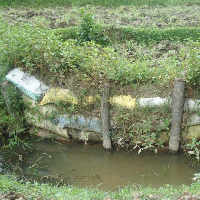
A retaining wall built using earth-filled sacks and bamboo posts. Tree seedlings and local grasses are planted on top of the retaining wall to help stabilize it. ( (Sabita Aryal Khanna)
ຈຸດປະສົງຕົ້ນຕໍ
-
ປັບປຸງ ການຜະລິດ
-
ຫຼຸດຜ່ອນ, ປ້ອງກັນ, ຟື້ນຟູ ການເຊື່ອມໂຊມຂອງດິນ
-
ການອະນຸລັກ ລະບົບນິເວດ
-
ປົກປັກຮັກສານໍ້າ / ນໍ້າພື້ນທີ່ - ປະສົມປະສານກັບ ເຕັກໂນໂລຢີອື່ນໆ
-
ປົກປັກຮັກສາ / ການປັບປຸງຊີວະນາໆພັນ
-
ຫຼຸດຜ່ອນຄວາມສ່ຽງ ທາງໄພພິບັດທໍາມະຊາດ
-
ປັບຕົວຕໍ່ກັບການປ່ຽນແປງດິນຟ້າອາກາດ / ທີ່ຮ້າຍແຮງ ແລະ ຜົນກະທົບ
-
ຫຼຸດຜ່ອນຜົນກະທົບ ຈາກການປ່ຽນແປງດິນຟ້າອາກາດ
-
ສ້າງຜົນກະທົບ ທາງເສດຖະກິດ ທີ່ເປັນປະໂຫຍດ
-
ສ້າງຜົນກະທົບ ທີ່ເປັນທາງບວກ ໃຫ້ແກ່ສັງຄົມ
ການນໍາໃຊ້ດິນ
-
ດິນທີ່ປູກພືດ
ຈໍານວນ ລະດູການ ປູກໃນປີໜຶ່ງ: 2
-
ປ່າໄມ້ / ປ່າຜົນຜະລິດ ແລະ ການບໍລິການ: ເຄື່ອງປ່າຂອງດົງ, ໄມ້ຟືນ, Fodder
-
ທິດທາງໄຫຼຂອງນໍ້າ, ນໍ້າ, ດິນທາມ - ທໍ່ລະບາຍນໍ້າ, ທິດທາງນໍ້າ
ການສະໜອງນໍ້າ
-
ນໍ້າຝົນ
-
ປະສົມປະສານ ກັນລະຫວ່າງ ນໍ້າຝົນ ແລະ ນໍ້າຊົນລະປະທານ
-
ນໍາໃຊ້ ນໍ້າຊົນລະປະທານ ພຽງຢ່າງດຽວ
ຈຸດປະສົງທີ່ກ່ຽວຂ້ອງກັບການເຊື່ອມໂຊມຂອງດິນ
-
ປ້ອງກັນການເຊື່ອມໂຊມຂອງດິນ
-
ຫຼຸດຜ່ອນການເຊື່ອມໂຊມຂອງດິນ
-
ການຟື້ນຟູ / ຟື້ນຟູດິນທີ່ຊຸດໂຊມ
-
ປັບຕົວຕໍ່ການເຊື່ອມໂຊມຂອງດິນ
-
ບໍ່ສາມາດໃຊ້ໄດ້
ການເຊື່ອມໂຊມ ທີ່ຕ້ອງໄດ້ເອົາໃຈໃສ່
-
ດິນເຊາະເຈື່ອນ ໂດຍນໍ້າ - Wg: ການເຊາະເຈື່ອນຮ່ອງນ້ຳ / ຫ້ວຍ
ກຸ່ມການຄຸ້ມຄອງທີ່ດິນແບບຍືນຍົງ
-
ມາດຕະການ ຕັດຂວາງ ກັບຄວາມຄ້ອຍຊັນ
-
ຄວາມຫຼາກຫຼາຍຂອງນໍ້າ ແລະ ການລະບາຍ
ມາດຕະການ ການຄຸ້ມຄອງທີ່ດິນແບບຍືນຍົງ
-
ມາດຕະການ ທາງດ້ານພືດພັນ - V2: ຫຍ້າ ແລະ ພືດສະໝູນໄພທີ່ເປັນໄມ້ຢືນຕົ້ນ
-
ມາດຕະການໂຄງສ້າງ - S5: ເຂື່ອນໄຟຟ້າ, ຝາຍເກັບນໍ້າ, ອ່າງ, ໜອງ
ເທັກນິກການແຕ້ມຮູບ
ຂໍກຳນົດທາງເທັກນິກ
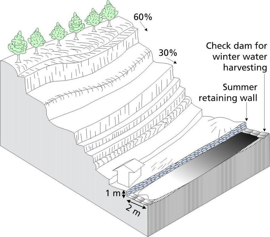
A jagidol area showing the approximate slope, bench terraces, and basic geometry of the landscape. With the shrine shown as in the photograph of the site.
Technical knowledge required for land users: moderate
Main technical functions: control of concentrated runoff: drain / divert, stabilisation of soil (eg by tree roots against land slides), water harvesting / increase water supply
Secondary technical functions: improvement of ground cover, spatial arrangement and diversification of land use
Author: Duncan Scott, A. K. Thaku
ການຈັດຕັ້ງ ແລະ ບໍາລຸງຮັກສາ: ກິດຈະກໍາ, ວັດຖຸດິບ ແລະ ຄ່າໃຊ້ຈ່າຍ
ການຄຳນວນ ປັດໃຈການຜະລິດ ແລະ ຄ່າໃຊ້ຈ່າຍ
- ຄິດໄລ່ຄ່າໃຊ້ຈ່າຍ: ຕໍ່ພື້ນທີ່ ທີ່ໄດ້ຈັດຕັ້ງປະຕິບັດ ເຕັກໂນໂລຢີ (ຂະໜາດ ແລະ ຫົວໜ່ວຍ ຂອງພື້ນທີ່:sq km)
- ສະກຸນເງິນທີ່ໃຊ້ສໍາລັບການຄິດໄລ່ຄ່າໃຊ້ຈ່າຍ: USA
- ອັດຕາແລກປ່ຽນ (ເປັນເງີນ ໂດລາ): 1 USD = ບໍ່ມີຂໍ້ມູນ
- ຄ່າແຮງງານສະເລ່ຍ ຂອງການຈ້າງແຮງງານຕໍ່ມື້: 4.50
ປັດໄຈທີ່ສໍາຄັນສຸດທີ່ສົ່ງຜົນກະທົບຕໍ່ຄ່າໃຊ້ຈ່າຍ
The construction and maintenance of gullies demands attention during a busy agricultural calendar and can significantly add to the labour costs depending on the size and number of gullies and dams that need to be constructed and maintained.
ກິດຈະກໍາການສ້າງຕັ້ງ
-
Local grasses such as utis, sito, amrisho, daleghas, and bamboo, can be planted on top of the reinforcements. (ໄລຍະເວລາ / ຄວາມຖີ່: None)
-
Construction of dam with mud-filled sacks Construction of stone dam and spillways• Construction of retaining wall• Construction of bunds and barrier (ໄລຍະເວລາ / ຄວາມຖີ່: None)
ປັດໄຈນໍາເຂົ້າໃນການຈັດຕັ້ງ ແລະ ຄ່າໃຊ້ຈ່າຍ (per sq km)
| ລະບຸ ປັດໃຈ ນໍາເຂົ້າ ໃນການຜະລີດ |
ຫົວໜ່ວຍ |
ປະລິມານ |
ຕົ້ນທຶນ ຕໍ່ຫົວໜ່ວຍ (USA) |
ຕົ້ນທຶນທັງໝົດ ຂອງປັດໃຈຂາເຂົ້າ ໃນການຜະລິດ (USA) |
% ຂອງຕົ້ນທຶນທັງໝົດ ທີ່ຜູ້ນໍາໃຊ້ທີ່ດິນ ໃຊ້ຈ່າຍເອງ |
|
ແຮງງານ
|
| Plant grasses |
persons/day/sq km |
150.0 |
4.5 |
675.0 |
100.0 |
|
ອຸປະກອນ
|
| Equipment |
sq km |
1.0 |
225.0 |
225.0 |
100.0 |
|
ວັດສະດຸກໍ່ສ້າງ
|
| Material |
sq km |
1.0 |
725.0 |
725.0 |
100.0 |
| ຕົ້ນທຶນທັງໝົດ ໃນການຈັດຕັ້ງປະຕິບັດ ເຕັກໂນໂລຢີ |
1'625.0 |
|
| ຄ່າໃຊ້ຈ່າຍທັງໝົດ ສຳລັບການສ້າງຕັ້ງເຕັກໂນໂລຢີ ເປັນສະກຸນເງີນໂດລາ |
1'625.0 |
|
ກິດຈະກໍາບໍາລຸງຮັກສາ
-
Continue to reinforce by planting with local grasses or bamboo on top of the structures until the plantings are well established. (ໄລຍະເວລາ / ຄວາມຖີ່: None)
ປັດໄຈນໍາເຂົ້າໃນການບໍາລຸງຮັກສາ ແລະ ຄ່າໃຊ້ຈ່າຍ (per sq km)
| ລະບຸ ປັດໃຈ ນໍາເຂົ້າ ໃນການຜະລີດ |
ຫົວໜ່ວຍ |
ປະລິມານ |
ຕົ້ນທຶນ ຕໍ່ຫົວໜ່ວຍ (USA) |
ຕົ້ນທຶນທັງໝົດ ຂອງປັດໃຈຂາເຂົ້າ ໃນການຜະລິດ (USA) |
% ຂອງຕົ້ນທຶນທັງໝົດ ທີ່ຜູ້ນໍາໃຊ້ທີ່ດິນ ໃຊ້ຈ່າຍເອງ |
|
ແຮງງານ
|
| Reinforce by planting on structure |
persons/day/sq km |
50.0 |
5.0 |
250.0 |
100.0 |
|
ອຸປະກອນ
|
| Equipment |
sq km |
1.0 |
70.0 |
70.0 |
100.0 |
|
ວັດສະດຸກໍ່ສ້າງ
|
| Material |
sq km |
1.0 |
350.0 |
350.0 |
100.0 |
| ຕົ້ນທຶນທັງໝົດ ທີ່ໃຊ້ໃນການບໍາລຸງຮັກສາ ເຕັກໂນໂລຢີ |
670.0 |
|
| ຄ່າໃຊ້ຈ່າຍທັງໝົດ ສຳລັບການບົວລະບັດຮກສາເຕັກໂນໂລຢີ ເປັນສະກຸນເງີນໂດລາ |
670.0 |
|
ສະພາບແວດລ້ອມທໍາມະຊາດ
ສະເລ່ຍປະລິມານນໍ້າຝົນປະຈໍາປີ
-
< 250 ມີລິແມັດ
-
251-500 ມີລິແມັດ
-
501-750 ມີລິແມັດ
-
751-1,000 ມີລິແມັດ
-
1,001-1,500 ມີລິແມັດ
-
1,501-2,000 ມີລິແມັດ
-
2,001-3,000 ມີລິແມັດ
-
3,001-4,000 ມີລິແມັດ
-
> 4,000 ມີລິແມັດ
ເຂດກະສິກໍາ-ສະພາບອາກາດ
-
ຄວາມຊຸ່ມ
-
ເຄີ່ງຄວາມຊຸ່ມ
-
ເຄິ່ງແຫ້ງແລ້ງ
-
ແຫ້ງແລ້ງ
ຂໍ້ມູນຈໍາເພາະກ່ຽວກັບສະພາບອາກາດ
Thermal climate class: subtropics
ຄວາມຄ້ອຍຊັນ
-
ພື້ນທີ່ຮາບພຽງ (0-2%)
-
ອ່ອນ (3-5 %)
-
ປານກາງ (6-10 %)
-
ມ້ວນ (11-15 %)
-
ເນີນ(16-30%)
-
ໍຊັນ (31-60%)
-
ຊັນຫຼາຍ (>60%)
ຮູບແບບຂອງດິນ
-
ພູພຽງ / ທົ່ງພຽງ
-
ສັນພູ
-
ເປີ້ນພູ
-
ເນີນພູ
-
ຕີນພູ
-
ຮ່ອມພູ
ລະດັບຄວາມສູງ
-
0-100 ແມັດ a.s.l.
-
101-500 ແມັດ a.s.l.
-
501-1,000 ແມັດ a.s.l.
-
1,001-1,500 ແມັດ a.s.l.
-
1,501-2,000 ແມັດ a.s.l.
-
2,001-2,500 ແມັດ a.s.l.
-
2,501-3,000 ແມັດ a.s.l.
-
3,001-4,000 ແມັດ a.s.l.
-
> 4,000 ແມັດ a.s.l.
ເຕັກໂນໂລຢີໄດ້ຖືກນໍາໃຊ້ໃນ
-
ລັກສະນະສວດ
-
ລັກສະນະກີ່ວ
-
ບໍ່ກ່ຽວຂ້ອງ
ຄວາມເລິກຂອງດິນ
-
ຕື້ນຫຼາຍ (0-20 ຊັງຕີແມັດ)
-
ຕື້ນ (21-50 ຊຕມ)
-
ເລີກປານກາງ (51-80 ຊຕມ)
-
ເລິກ (81-120 ຊມ)
-
ເລິກຫຼາຍ (> 120 cm)
ໂຄງສ້າງຂອງດິນ (ເທີງໜ້າດິນ)
-
ຫຍາບ / ເບົາ (ດິນຊາຍ)
-
ປານກາງ (ດິນໜຽວ, ດິນໂຄນ)
-
ບາງລະອຽດ / ໜັກ (ໜຽວ)
ໂຄງສ້າງຂອງດິນ (ເລິກລົງ 20 ຊັງຕີແມັດ)
-
ຫຍາບ / ເບົາ (ດິນຊາຍ)
-
ປານກາງ (ດິນໜຽວ, ດິນໂຄນ)
-
ບາງລະອຽດ / ໜັກ (ໜຽວ)
ທາດອິນຊີຢູ່ເທິງໜ້າດິນ
-
ສູງ (> 3 %)
-
ປານກາງ (1-3 %)
-
ຕໍາ່ (<1 %)
ນ້ຳໃຕ້ດິນ
-
ເທິງຊັ້ນໜ້າດິນ
-
< 5 ແມັດ
-
5-50 ແມັດ
-
> 50 ແມັດ
ມີນໍ້າໜ້າດິນ
-
ເກີນ
-
ດີ
-
ປານກາງ
-
ທຸກຍາກ / ບໍ່ມີ
ຄຸນນະພາບນໍ້າ (ການຮັກສາ)
-
ມີນໍ້າດື່ມ
-
ບໍ່ມີນໍ້າດື່ມ (ຮຽກຮ້ອງໃຫ້ມີການບຳບັດນ້ຳ)
-
ນຳໃຊ້ເຂົ້າໃນການຜະລິດກະສິກໍາພຽງຢ່າງດຽງ (ຊົນລະປະທານ)
-
ຜິດປົກກະຕິ
ຄຸນນະພາບນ້ຳ ໝາຍເຖີງ:
ດິນເຄັມເປັນບັນຫາບໍ່?
ການເກີດນໍ້າຖ້ວມ
ຄວາມຫຼາກຫຼາຍຂອງສິ່ງທີ່ມີຊີວິດ
ຄຸນລັກສະນະຂອງຜູ້ນຳໃຊ້ທີ່ດິນການນໍາໃຊ້ເຕັກໂນໂລຢີ
ການວາງແນວທາງຕະຫຼາດ
-
ກຸ້ມຕົນເອງ (ພໍພຽງ)
-
ປະສົມປົນເປ( ກຸ້ມຕົນເອງ/ເປັນສິນຄ້າ)
-
ການຄ້າ / ຕະຫຼາດ
ລາຍຮັບທີ່ໄດ້ມາຈາກກິດຈະກໍາອື່ນໆ ທີ່ບໍ່ແມ່ນການຜະລິດກະສິກໍາ
-
ໜ້ອຍກ່ວາ 10 % ຂອງລາຍຮັບທັງໝົດ
-
10-50 % ຂອງລາຍຮັບທັງໝົດ
-
> 50 % ຂອງລາຍຮັບທັງໝົດ
ລະດັບຄວາມຮັ່ງມີ
-
ທຸກຍາກຫຼາຍ
-
ທຸກຍາກ
-
ສະເລ່ຍ
-
ຮັ່ງມີ
-
ຮັ່ງມີຫຼາຍ
ລະດັບຂອງການຫັນເປັນກົນຈັກ
-
ການໃຊ້ແຮງງານຄົນ
-
ສັດລາກແກ່
-
ເຄື່ອງກົນຈັກ
ຢູ່ປະຈຳ ຫຼື ເລລ້ອນ
-
ບໍ່ເຄື່ອນໄຫວ
-
ແບບເຄີ່ງຂັງ-ເຄີ່ງປ່ອຍ
-
ແບບປ່ອຍຕາມທຳມະຊາດ
ບຸກຄົນ ຫຼື ກຸ່ມ
-
ບຸກຄົນ / ຄົວເຮືອນ
-
ກຸ່ມ / ຊຸມຊົນ
-
ການຮ່ວມມື
-
ການຈ້າງງານ (ບໍລິສັດ, ອົງການ ລັດຖະບານ)
ອາຍຸ
-
ເດັກນ້ອຍ
-
ຊາວໜຸ່ມ
-
ໄວກາງຄົນ
-
ຜູ້ສູງອາຍຸ
ເຂດພື້ນທີ່ການນໍາໃຊ້ຕໍ່ຄົວເຮືອນ
-
<0.5 ເຮັກຕາ
-
0.5-1 ເຮັກຕາ
-
1-2 ເຮັກຕາ
-
2-5 ເຮັກຕາ
-
5-15 ເຮັກຕາ
-
15-50 ເຮັກຕາ
-
50-100 ເຮັກຕາ
-
100-500 ເຮັກຕາ
-
500-1,000 ເຮັກຕາ
-
1,000-10,000 ເຮັກຕາ
-
> 10,000 ເຮັກຕາ
ຂະໜາດ
-
ຂະໜາດນ້ອຍ
-
ຂະໜາດກາງ
-
ຂະໜາດໃຫຍ່
ເຈົ້າຂອງທີ່ດິນ
-
ລັດ
-
ບໍລິສັດ
-
ຊຸມຊົນ / ບ້ານ
-
ກຸ່ມ
-
ບຸກຄົນ, ບໍ່ມີຕໍາແໜ່ງ
-
ບຸກຄົນ, ທີ່ມີຕໍາແໜ່ງ
ສິດທິການນໍາໃຊ້ທີ່ດິນ
-
ເປີດກວ້າງ (ບໍ່ມີການຈັດຕັ້ງ)
-
ຊຸມຊົນ (ທີ່ມີການຈັດຕັ້ງ)
-
ເຊົ່າ
-
ບຸກຄົນ
ສິດທິການນໍາໃຊ້ນໍ້າ
-
ເປີດກວ້າງ (ບໍ່ມີການຈັດຕັ້ງ)
-
ຊຸມຊົນ (ທີ່ມີການຈັດຕັ້ງ)
-
ເຊົ່າ
-
ບຸກຄົນ
ການເຂົ້າເຖິງການບໍລິການ ແລະ ພື້ນຖານໂຄງລ່າງ
ການຈ້າງງານ (ຕົວຢ່າງ, ການເຮັດກິດຈະກໍາອື່ນ ທີ່ບໍ່ແມ່ນ ການຜະລິດກະສິກໍາ)
ຖະໜົນຫົນທາງ ແລະ ການຂົນສົ່ງ
ການດື່ມນໍ້າ ແລະ ສຸຂາພິບານ
ການບໍລິການ ທາງດ້ານການເງິນ
ຜົນກະທົບ
ຜົນກະທົບທາງສັງຄົມ ແລະ ເສດຖະກິດ
ເນື້ອທີ່ ການຜະລິດ (ທີ່ດິນໃໝ່ ທີ່ໄດ້ປູກພືດໃສ່ / ນໍາໃຊ້)
reduce risk of land degredation
ຜົນກະທົບທາງສັງຄົມ ວັດທະນະທໍາ
ໂອກາດ ທາງດ້ານວັດທະນະທໍາ (ຕົວຢ່າງ, ກ່ຽວກັບ ວິນຍານ, ສິລະປະ ແລະ ອື່ນໆ)
agricultural benefits the whole community at many different levels including social-cultural
livelihood and human well-being
improved agriculture leads to food sufficiency, enhanced economic conditions, and better health throughout the community. When households have more cash income they usually invest it in education for their children
ຜົນກະທົບຕໍ່ລະບົບນິເວດ
ມວນຊີວະພາບ / ຢູ່ເທິງຊັ້ນດິນ C
ຄວາມຫຼາກຫຼາຍ ທາງດ້ານທີ່ຢູ່ອາໃສ ຂອງສິ່ງທີ່ມີຊີວິດ
ການຄວບຄຸມສັດຕູພືດ / ພະຍາດ
ຜົນກະທົບ ຂອງລົມພາຍຸໄຊໂຄນ, ພາຍຸຝົນຕົກໜັກ
competition for water, sunlight and nutrients
ຜົນກະທົບນອກສະຖານທີ່
ນໍ້າຖ້ວມຢູ່ເຂດລຸ່ມນໍ້າ (ທີ່ບໍ່ພຶງປາດຖະໜາ)
Downstream Neighbor field also benefit from slop stability and soil conservation
ການວິເຄາະຕົ້ນທຶນ ແລະ ຜົນປະໂຫຍດ
ຜົນປະໂຫຍດເມື່ອທຽບກັບຄ່າໃຊ້ຈ່າຍໃນການສ້າງຕັ້ງ
ຜົນຕອບແທນ ໃນໄລຍະສັ້ນ
ຜົນກະທົບທາງລົບຫຼາຍ
ຜົນກະທົບທາງບວກຫຼາຍ
ຜົນຕອບແທນ ໃນໄລຍະຍາວ
ຜົນກະທົບທາງລົບຫຼາຍ
ຜົນກະທົບທາງບວກຫຼາຍ
ຜົນປະໂຫຍດເມື່ອທຽບກັບຄ່າໃຊ້ຈ່າຍບໍາລຸງຮັກສາ
ຜົນຕອບແທນ ໃນໄລຍະສັ້ນ
ຜົນກະທົບທາງລົບຫຼາຍ
ຜົນກະທົບທາງບວກຫຼາຍ
ຜົນຕອບແທນ ໃນໄລຍະຍາວ
ຜົນກະທົບທາງລົບຫຼາຍ
ຜົນກະທົບທາງບວກຫຼາຍ
ການປ່ຽນແປງສະພາບດິນຟ້າອາກາດ
ການປ່ຽນແປງດິນຟ້າອາກາດ ເທື່ອລະກ້າວ
ອຸນຫະພູມປະຈໍາປີ ເພີ່ມຂື້ນ
ອາກາດ ທີ່ກ່ຽວພັນກັບຄວາມຮຸນແຮງ (ໄພພິບັດທາງທໍາມະຊາດ)
ການຍອມຮັບ ແລະ ການປັບຕົວ
ອັດຕາສ່ວນຂອງຜູ້ຊົມໃຊ້ທີ່ດິນໃນເຂດພື້ນທີ່ທີ່ໄດ້ຮັບຮອງເອົາເຕັກໂນໂລຢີ
-
ກໍລະນີດຽວ / ການທົດລອງ
-
1-10%
-
11-50%
-
> 50%
ທັງໝົດນັ້ນ ມີໃຜແດ່ທີ່ສາມາດປັບຕົວຕໍ່ເຕັກໂນໂລຢີ, ມີຈັກຄົນທີ່ໄດ້ຮັບການກະຕຸກຊຸກຍູ້ ແລະ ອຸປະກອນ?
-
0-10%
-
11-50%
-
51-90%
-
91-100%
ໄດ້ມີການດັດແປງເຕັກໂນໂລຢີ ເພື່ອປັບໃຫ້ເຂົ້າກັບເງື່ອນໄຂການປ່ຽນແປງບໍ່?
ໄດ້ປ່ຽນແປງເງື່ອນໄຂຫຍັງແດ່?
-
ການປ່ຽນແປງດິນຟ້າອາກາດ / ຮ້າຍແຮງ
-
ຕະຫຼາດມີການປ່ຽນແປງ
-
ມີແຮງງານ (ຕົວຢ່າງ, ເນື່ອງຈາກການເຄື່ອນຍ້າຍແຮງງານ)
ບົດສະຫຼຸບ ແລະ ບົດຮຽນທີ່ໄດ້ຮັບ
ຄວາມເຂັ້ມແຂງ: ທັດສະນະມູມມອງ ຂອງຜູ້ນໍາໃຊ້ທີ່ດິນ
ຄວາມເຂັ້ມແຂງ: ທັດສະນະມຸມມອງ ຂອງຜູ້ປ້ອນຂໍ້ມູນເອງ
-
This is a well-accepted local practice.
How can they be sustained / enhanced? Continue to implement this soil conservation measure.
-
The use of mud-filled sacs is a recent innovation.
How can they be sustained / enhanced? Some advance training may be needed.
-
Reduced risk of losing crops and agricultural land because of soil degradation.
How can they be sustained / enhanced? Continue to add to mud-based structures by vegetative means.
-
An added benefit is the production of biomass: grass, fodder for animals, wood, and fuelwood.
How can they be sustained / enhanced? Continue to plant more trees.
-
Makes water available for irrigation even during the dry season.
How can they be sustained / enhanced? Encourage more check dam construction along the gully.
ຈຸດອ່ອນ / ຂໍ້ເສຍ / ຄວາມສ່ຽງ: ທັດສະນະມູມມອງ ຂອງຜູ້ນໍາໃຊ້ທີ່ດິນວິທີການແກ້ໄຂແນວໃດ
ຈຸດອ່ອນ / ຂໍ້ເສຍ / ຄວາມສ່ຽງ: ທັດສະນະມຸມມອງ ຂອງຜູ້ປ້ອນຂໍ້ມູນເອງວິທີການແກ້ໄຂແນວໃດ
-
The traditional materials used in the construction of dams and gullies are prone to damage during flood events
The technology can be enhanced by the use of better materials and technical support. With research and funding, more robust conservation measures can be implemented.
-
In recent times, new activities such as brick making are coming to the villages; the entrepreneurs involved in these activities do not know about (and are not interested in) soil conservation measures
Increase awareness among newcomers.
-
There has never been any external support for these soil conservation activities even if downstream communities also benefit
Increase awareness among downstream communities. Explore possibilities for external support for controlled gullying.
ເອກກະສານອ້າງອີງ
ການທົບທວນຄືນ
-
David Streiff
-
Alexandra Gavilano
ວັນທີຂອງການປະຕິບັດ: Aug. 10, 2015
ປັບປຸງລ່າສຸດ: June 4, 2019
ບຸກຄົນທີ່ສໍາຄັນ
-
Shreedip Sigdel - ຜຸ້ຊ່ຽວຊານ ດ້ານການຄຸ້ມຄອງ ທີ່ດິນແບບຍືນຍົງ
-
Sabita Aryal - ຜຸ້ຊ່ຽວຊານ ດ້ານການຄຸ້ມຄອງ ທີ່ດິນແບບຍືນຍົງ
ການບັນຍາຍລາຍລະອຽດ ໃນຖານຂໍ້ມູນ ຂອງ WOCAT
ຂໍ້ມູນການເຊື່ອມໂຍງຂໍ້ມູນການຄຸ້ມຄອງການນໍາໃຊ້ດິນແບບຍືນຍົງ
ເອກກະສານ ແມ່ນໄດ້ອໍານວຍຄວາມສະດວກໂດຍ
ສະຖາບັນ
- ICIMOD International Centre for Integrated Mountain Development (ICIMOD) - ເນໂປ
- Kathmandu University (KU) - ເນໂປ
ໂຄງການ