Rainwater Harvesting for Olive Production
(ປາເລສຕິນ)
ຄຳອະທິບາຍ
Microcatchment water harvesting captures, stores and allows safe overflow of excess surface runoff collected during heavy rainfall events. The intercepted and deep-infiltrated water enhances soil moisture at/around the microcatchment structure. This eventually boosts plant productivity in dry areas, mitigates land degradation, and benefits the local farming communities’ livelihoods
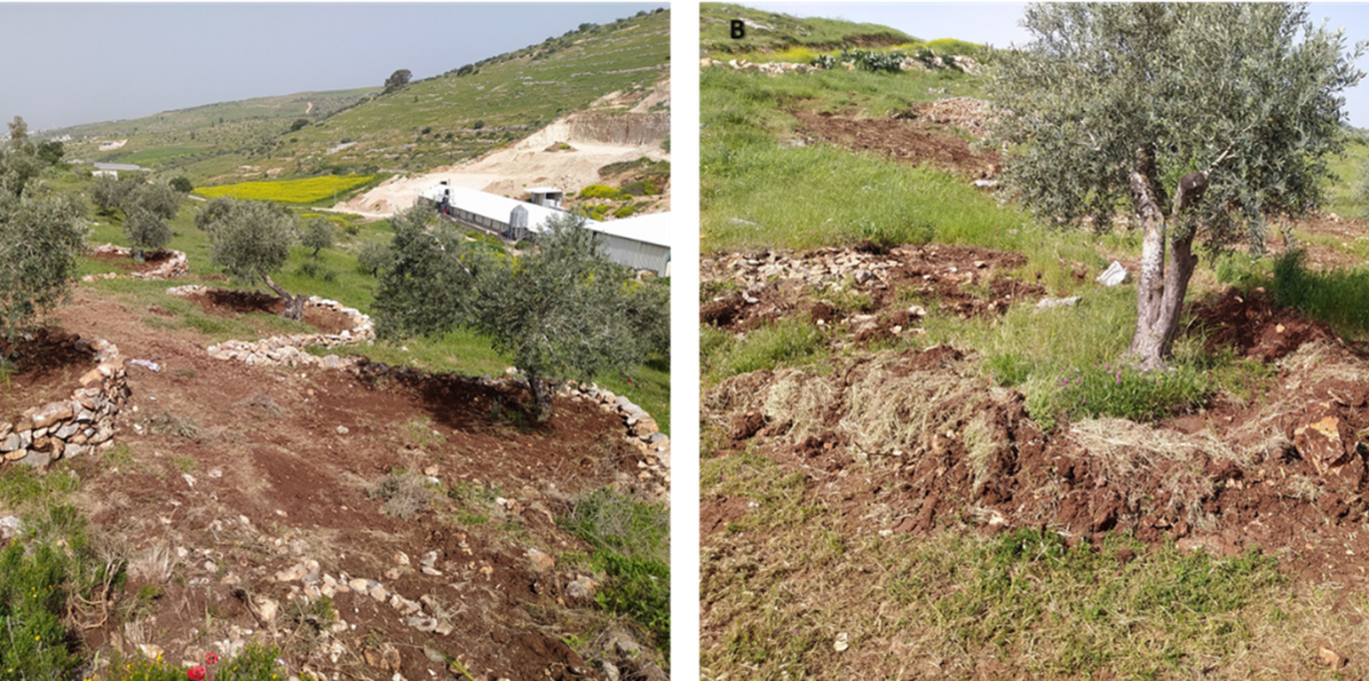
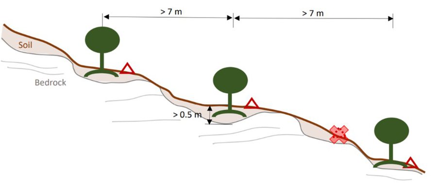
In Palestine, rainfed olives are traditionally cultivated within undulating landscapes with an average annual precipitation ranging between 400 and 700 mm. Olive trees are well known for their resilience to droughts. However, degraded and steeply sloping areas have limited water infiltration and storage capacity: a large proportion of rain forms surface runoff, further speeding up land degradation through erosion and the removal of fertile topsoil, leading to decreased soil health and productivity. The International Center of Agriculture Research in Dry Areas (ICARDA) among others, recognised these issues and superimposed microcatchment water harvesting structures on existing rainfed olive trees in marginal and degraded drylands of Palestine. This technique aims to improve yields by increasing soil moisture through capturing runoff and enhancing infiltration. Thereby, it also decreases the potential for land degradation through surface runoff. This has positive impacts on the local land users and land owners. These are often considered marginalised groups because they lack access to off-farm work and finance to invest in their farms. Additionally, these farmers are directly experiencing the negative impacts of climate change, such as more frequent droughts which can be linked to declining yields, and decreasing farm income. Depending on local climate, topographic and soil conditions, olive trees are usually spaced 5-10 meters apart to avoid competition for water.
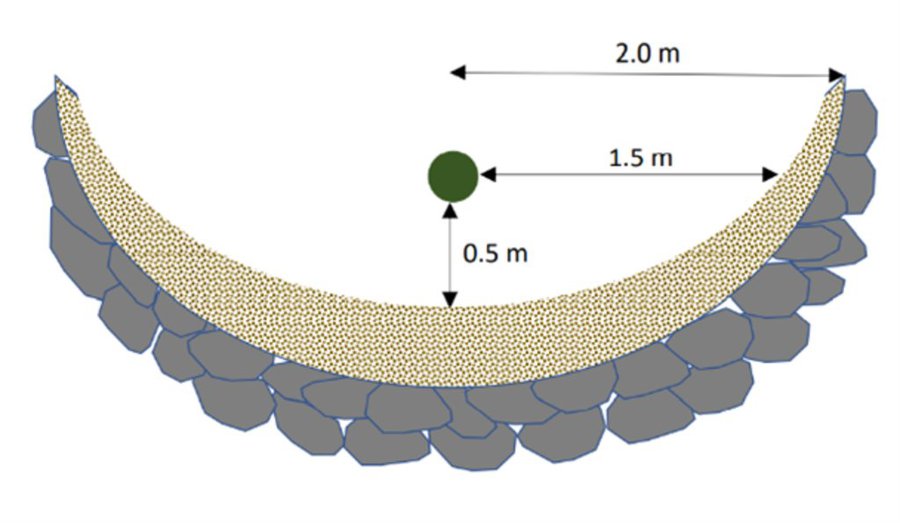
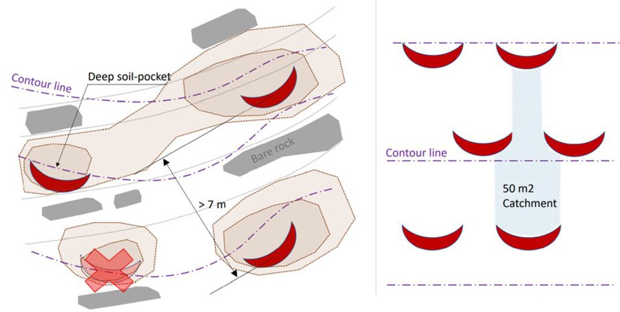
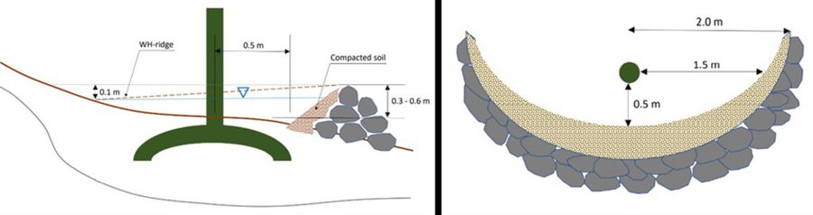
The land is first surveyed and then the microcatchment water harvesting structures (technically termed “semi-circular bunds”) are designed with the tips of the structures on the contour. They are constructed around 0.5 meters downslope of each olive tree in a semi-circle of around 4 meters diameter. The structures are created through stone foundation and bunds topped with a compacted soil layer. The height of the structures varies between 0.3 meters and 1.2 meters. As a first step, stones are placed and fixed in a semi-circular shape. Secondly, the soil inside the structure is slightly levelled. Thirdly, more stones are placed to heighten the bunds. Lastly, excavated and surround soil is put over the stones and thoroughly compacted. The estimation of establishment cost is 7 USD per meter of bund, implying a total cost of approximately 7000 USD per hectare.
The life-duration of the water harvesting system implemented in highly sloping areas, is estimated at 15 years with yearly maintenance cost estimated at 3 USD per tree – 300 USD per hectare. Without maintenance, the life-cycle of the system will be less.
Land users appreciate the technology because it improves their olive yields and thus income. They state that the topsoil maintained in situ, and the improved soil moisture, have positive effects on their harvest. Land users also acknowledge that implementing and maintaining increases the workload. Nevertheless, due to the local material requirements, the costs are low and thus perceived as positive.
Data presented in this documentation are partly made available under the project 'Testing and Out-scaling in situ Water Harvesting Technologies in Palestine' led by ICARDA in collaboration with the Applied Research Institute Jerusalem, Palestinian Ministry of Agriculture, and National Agricultural Research Centre in Palestine. The project is under the Food and Agriculture Organization of the United Nations (FAO) – a regional project “Implementing the 2030 Agenda for water efficiency/productivity and water sustainability in NENA countries” directly under the Regional Water Scarcity Initiative. The Swedish International Development Cooperation Agency funded the project.
ສະຖານທີ່
ສະຖານທີ່: ປາເລສຕິນ
ຈໍານວນ ພື້ນທີ່ ທີ່ໃຊ້ ເຕັກໂນໂລຢີ ທີ່ໄດ້ວິເຄາະ: ພື້ນທີ່ດຽວ
ການຄັດເລືອກພື້ນທີ່ ທີ່ອີງໃສ່ຂໍ້ມູນທາງພູມີສາດ
ການແຜ່ກະຈາຍຂອງເຕັກໂນໂລຢີ: ແຜ່ຂະຫຍາຍຢ່າງໄວວາໃນພື້ນທີ່ (approx. 0.1-1 ກມ 2)
ຢູ່ໃນເຂດປ່າສະຫງວນທີ່ບໍ?: ບໍ່ແມ່ນ
ວັນທີຂອງການປະຕິບັດ: 2021
ປະເພດຂອງການນໍາສະເໜີ
-
ໂດຍຜ່ານນະວັດຕະກໍາຄິດຄົ້ນຂອງຜູ້ນໍາໃຊ້ທີ່ດິນ
-
ເປັນສ່ວນໜື່ງຂອງລະບົບພື້ນເມືອງ (>50 ປີ)
-
ໃນໄລຍະການທົດລອງ / ການຄົ້ນຄວ້າ
-
ໂດຍຜ່ານໂຄງການ / ການຊ່ວຍເຫຼືອຈາກພາຍນອກ
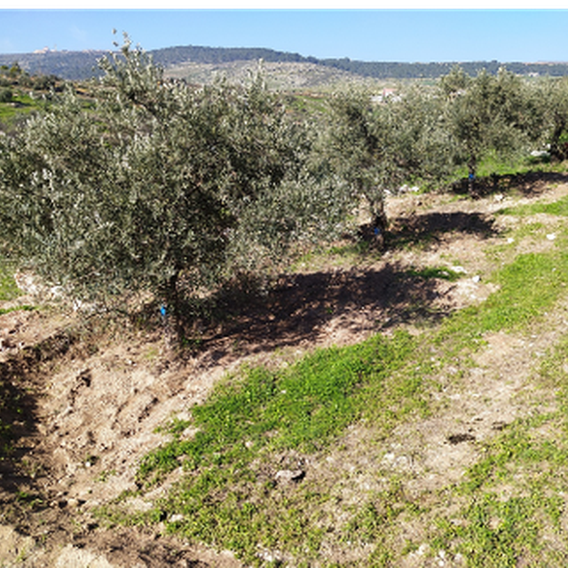
An older water harvesting structure (ARIJ)
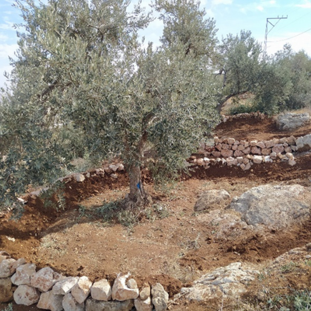
Freshly implemented water harvesting structure (ARIJ)
ຈຸດປະສົງຕົ້ນຕໍ
-
ປັບປຸງ ການຜະລິດ
-
ຫຼຸດຜ່ອນ, ປ້ອງກັນ, ຟື້ນຟູ ການເຊື່ອມໂຊມຂອງດິນ
-
ການອະນຸລັກ ລະບົບນິເວດ
-
ປົກປັກຮັກສານໍ້າ / ນໍ້າພື້ນທີ່ - ປະສົມປະສານກັບ ເຕັກໂນໂລຢີອື່ນໆ
-
ປົກປັກຮັກສາ / ການປັບປຸງຊີວະນາໆພັນ
-
ຫຼຸດຜ່ອນຄວາມສ່ຽງ ທາງໄພພິບັດທໍາມະຊາດ
-
ປັບຕົວຕໍ່ກັບການປ່ຽນແປງດິນຟ້າອາກາດ / ທີ່ຮ້າຍແຮງ ແລະ ຜົນກະທົບ
-
ຫຼຸດຜ່ອນຜົນກະທົບ ຈາກການປ່ຽນແປງດິນຟ້າອາກາດ
-
ສ້າງຜົນກະທົບ ທາງເສດຖະກິດ ທີ່ເປັນປະໂຫຍດ
-
ສ້າງຜົນກະທົບ ທີ່ເປັນທາງບວກ ໃຫ້ແກ່ສັງຄົມ
ການນໍາໃຊ້ດິນ
ການນຳໃຊ້ທີ່ດິນ ປະສົມພາຍໃນພື້ນທີ່ດຽວກັນ: ບໍ່ແມ່ນ
-
ດິນທີ່ປູກພືດ
- ເປັນໄມ້ຢືນຕົ້ນ ແລະ ໄມ້ພຸ່ມ ຈາກການປູກພືດ: ຕົ້ນໂອລີບ
ມີການເຝືກປູກພືດແບບສັບຫວ່າງບໍ່? ບໍ່ແມ່ນ
ມີການເຝືກປູກພືດແບບໝູນວຽນບໍ່? ບໍ່ແມ່ນ
ການສະໜອງນໍ້າ
-
ນໍ້າຝົນ
-
ປະສົມປະສານ ກັນລະຫວ່າງ ນໍ້າຝົນ ແລະ ນໍ້າຊົນລະປະທານ
-
ນໍາໃຊ້ ນໍ້າຊົນລະປະທານ ພຽງຢ່າງດຽວ
ຈຸດປະສົງທີ່ກ່ຽວຂ້ອງກັບການເຊື່ອມໂຊມຂອງດິນ
-
ປ້ອງກັນການເຊື່ອມໂຊມຂອງດິນ
-
ຫຼຸດຜ່ອນການເຊື່ອມໂຊມຂອງດິນ
-
ການຟື້ນຟູ / ຟື້ນຟູດິນທີ່ຊຸດໂຊມ
-
ປັບຕົວຕໍ່ການເຊື່ອມໂຊມຂອງດິນ
-
ບໍ່ສາມາດໃຊ້ໄດ້
ການເຊື່ອມໂຊມ ທີ່ຕ້ອງໄດ້ເອົາໃຈໃສ່
-
ດິນເຊາະເຈື່ອນ ໂດຍນໍ້າ - Wt: ການສູນເສຍຊັ້ນໜ້າດິນ / ການເຊາະເຈື່ອນຜິວໜ້າດິນ, Wg: ການເຊາະເຈື່ອນຮ່ອງນ້ຳ / ຫ້ວຍ, Wm: ການເຄື່ອນຍ້າຍອິນຊີວັດຖຸ / ດິນເຈື່ອນ
-
ດິນເຊາະເຈື່ອນ ໂດຍລົມ - ການສູນເສຍຊັ້ນໜ້າດິນ
ກຸ່ມການຄຸ້ມຄອງທີ່ດິນແບບຍືນຍົງ
-
ການຄຸ້ມຄອງການປູກປ່າ
-
ມາດຕະການ ຕັດຂວາງ ກັບຄວາມຄ້ອຍຊັນ
-
ການເກັບກັກນໍ້າ
ມາດຕະການ ການຄຸ້ມຄອງທີ່ດິນແບບຍືນຍົງ
-
ມາດຕະການໂຄງສ້າງ - S2: ຄັນຄຸ, ແຄມຕາຝັ່ງ , S7: ອຸປະກອນເກັບຮັກສາ, ສະໜອງນ້ຳ, ຊົນລະປະທານ
ເທັກນິກການແຕ້ມຮູບ
ຂໍກຳນົດທາງເທັກນິກ
Microcatchment rainwater harvesting design, with detailed cross-sectional (left) and top (right) views; definition of dimensions
Microcatchment rainwater harvesting design in hillslope direction; definition of spacing constrained by the local ‘soil pocket’ hillslope pattern.
Microcatchment rainwater harvesting design from a top view; definition of minimum microcatchment areas contributing to the rainwater harvesting pits.
Microcatchment rainwater harvesting design, with detailed cross-sectional (left) and top (right) views; definition of dimensions.
ການຈັດຕັ້ງ ແລະ ບໍາລຸງຮັກສາ: ກິດຈະກໍາ, ວັດຖຸດິບ ແລະ ຄ່າໃຊ້ຈ່າຍ
ການຄຳນວນ ປັດໃຈການຜະລິດ ແລະ ຄ່າໃຊ້ຈ່າຍ
- ຄິດໄລ່ຄ່າໃຊ້ຈ່າຍ: ຕໍ່ພື້ນທີ່ ທີ່ໄດ້ຈັດຕັ້ງປະຕິບັດ ເຕັກໂນໂລຢີ (ຂະໜາດ ແລະ ຫົວໜ່ວຍ ຂອງພື້ນທີ່:1 Hectare)
- ສະກຸນເງິນທີ່ໃຊ້ສໍາລັບການຄິດໄລ່ຄ່າໃຊ້ຈ່າຍ: USA
- ອັດຕາແລກປ່ຽນ (ເປັນເງີນ ໂດລາ): 1 USD = ບໍ່ມີຂໍ້ມູນ
- ຄ່າແຮງງານສະເລ່ຍ ຂອງການຈ້າງແຮງງານຕໍ່ມື້: ບໍ່ມີຂໍ້ມູນ
ປັດໄຈທີ່ສໍາຄັນສຸດທີ່ສົ່ງຜົນກະທົບຕໍ່ຄ່າໃຊ້ຈ່າຍ
n.a.
ກິດຈະກໍາການສ້າງຕັ້ງ
-
Field survey for contours (ໄລຍະເວລາ / ຄວາມຖີ່: None)
-
Place Stones (ໄລຍະເວລາ / ຄວາມຖີ່: None)
-
Soil Removal (ໄລຍະເວລາ / ຄວາມຖີ່: None)
-
Stone bund around tree (ໄລຍະເວລາ / ຄວາມຖີ່: None)
-
Stone bund topped with excavated soil (ໄລຍະເວລາ / ຄວາມຖີ່: None)
ຕົ້ນທຶນທັງໝົດ ໃນການຈັດຕັ້ງປະຕິບັດ (ໂດຍການປະມານ)
7000.0
ກິດຈະກໍາບໍາລຸງຮັກສາ
-
Incidental repairs (ໄລຍະເວລາ / ຄວາມຖີ່: None)
ຕົ້ນທຶນທັງໝົດ ໃນການບໍາລຸງຮັກສາ (ໂດຍການປະມານ)
300.0
ສະພາບແວດລ້ອມທໍາມະຊາດ
ສະເລ່ຍປະລິມານນໍ້າຝົນປະຈໍາປີ
-
< 250 ມີລິແມັດ
-
251-500 ມີລິແມັດ
-
501-750 ມີລິແມັດ
-
751-1,000 ມີລິແມັດ
-
1,001-1,500 ມີລິແມັດ
-
1,501-2,000 ມີລິແມັດ
-
2,001-3,000 ມີລິແມັດ
-
3,001-4,000 ມີລິແມັດ
-
> 4,000 ມີລິແມັດ
ເຂດກະສິກໍາ-ສະພາບອາກາດ
-
ຄວາມຊຸ່ມ
-
ເຄີ່ງຄວາມຊຸ່ມ
-
ເຄິ່ງແຫ້ງແລ້ງ
-
ແຫ້ງແລ້ງ
ຂໍ້ມູນຈໍາເພາະກ່ຽວກັບສະພາບອາກາດ
n.a.
ຄວາມຄ້ອຍຊັນ
-
ພື້ນທີ່ຮາບພຽງ (0-2%)
-
ອ່ອນ (3-5 %)
-
ປານກາງ (6-10 %)
-
ມ້ວນ (11-15 %)
-
ເນີນ(16-30%)
-
ໍຊັນ (31-60%)
-
ຊັນຫຼາຍ (>60%)
ຮູບແບບຂອງດິນ
-
ພູພຽງ / ທົ່ງພຽງ
-
ສັນພູ
-
ເປີ້ນພູ
-
ເນີນພູ
-
ຕີນພູ
-
ຮ່ອມພູ
ລະດັບຄວາມສູງ
-
0-100 ແມັດ a.s.l.
-
101-500 ແມັດ a.s.l.
-
501-1,000 ແມັດ a.s.l.
-
1,001-1,500 ແມັດ a.s.l.
-
1,501-2,000 ແມັດ a.s.l.
-
2,001-2,500 ແມັດ a.s.l.
-
2,501-3,000 ແມັດ a.s.l.
-
3,001-4,000 ແມັດ a.s.l.
-
> 4,000 ແມັດ a.s.l.
ເຕັກໂນໂລຢີໄດ້ຖືກນໍາໃຊ້ໃນ
-
ລັກສະນະສວດ
-
ລັກສະນະກີ່ວ
-
ບໍ່ກ່ຽວຂ້ອງ
ຄວາມເລິກຂອງດິນ
-
ຕື້ນຫຼາຍ (0-20 ຊັງຕີແມັດ)
-
ຕື້ນ (21-50 ຊຕມ)
-
ເລີກປານກາງ (51-80 ຊຕມ)
-
ເລິກ (81-120 ຊມ)
-
ເລິກຫຼາຍ (> 120 cm)
ໂຄງສ້າງຂອງດິນ (ເທີງໜ້າດິນ)
-
ຫຍາບ / ເບົາ (ດິນຊາຍ)
-
ປານກາງ (ດິນໜຽວ, ດິນໂຄນ)
-
ບາງລະອຽດ / ໜັກ (ໜຽວ)
ໂຄງສ້າງຂອງດິນ (ເລິກລົງ 20 ຊັງຕີແມັດ)
-
ຫຍາບ / ເບົາ (ດິນຊາຍ)
-
ປານກາງ (ດິນໜຽວ, ດິນໂຄນ)
-
ບາງລະອຽດ / ໜັກ (ໜຽວ)
ທາດອິນຊີຢູ່ເທິງໜ້າດິນ
-
ສູງ (> 3 %)
-
ປານກາງ (1-3 %)
-
ຕໍາ່ (<1 %)
ນ້ຳໃຕ້ດິນ
-
ເທິງຊັ້ນໜ້າດິນ
-
< 5 ແມັດ
-
5-50 ແມັດ
-
> 50 ແມັດ
ມີນໍ້າໜ້າດິນ
-
ເກີນ
-
ດີ
-
ປານກາງ
-
ທຸກຍາກ / ບໍ່ມີ
ຄຸນນະພາບນໍ້າ (ການຮັກສາ)
-
ມີນໍ້າດື່ມ
-
ບໍ່ມີນໍ້າດື່ມ (ຮຽກຮ້ອງໃຫ້ມີການບຳບັດນ້ຳ)
-
ນຳໃຊ້ເຂົ້າໃນການຜະລິດກະສິກໍາພຽງຢ່າງດຽງ (ຊົນລະປະທານ)
-
ຜິດປົກກະຕິ
ຄຸນນະພາບນ້ຳ ໝາຍເຖີງ: ນ້ຳໜ້າດິນ
ດິນເຄັມເປັນບັນຫາບໍ່?
ການເກີດນໍ້າຖ້ວມ
ຄວາມຫຼາກຫຼາຍຂອງສິ່ງທີ່ມີຊີວິດ
ຄຸນລັກສະນະຂອງຜູ້ນຳໃຊ້ທີ່ດິນການນໍາໃຊ້ເຕັກໂນໂລຢີ
ການວາງແນວທາງຕະຫຼາດ
-
ກຸ້ມຕົນເອງ (ພໍພຽງ)
-
ປະສົມປົນເປ( ກຸ້ມຕົນເອງ/ເປັນສິນຄ້າ)
-
ການຄ້າ / ຕະຫຼາດ
ລາຍຮັບທີ່ໄດ້ມາຈາກກິດຈະກໍາອື່ນໆ ທີ່ບໍ່ແມ່ນການຜະລິດກະສິກໍາ
-
ໜ້ອຍກ່ວາ 10 % ຂອງລາຍຮັບທັງໝົດ
-
10-50 % ຂອງລາຍຮັບທັງໝົດ
-
> 50 % ຂອງລາຍຮັບທັງໝົດ
ລະດັບຄວາມຮັ່ງມີ
-
ທຸກຍາກຫຼາຍ
-
ທຸກຍາກ
-
ສະເລ່ຍ
-
ຮັ່ງມີ
-
ຮັ່ງມີຫຼາຍ
ລະດັບຂອງການຫັນເປັນກົນຈັກ
-
ການໃຊ້ແຮງງານຄົນ
-
ສັດລາກແກ່
-
ເຄື່ອງກົນຈັກ
ຢູ່ປະຈຳ ຫຼື ເລລ້ອນ
-
ບໍ່ເຄື່ອນໄຫວ
-
ແບບເຄີ່ງຂັງ-ເຄີ່ງປ່ອຍ
-
ແບບປ່ອຍຕາມທຳມະຊາດ
ບຸກຄົນ ຫຼື ກຸ່ມ
-
ບຸກຄົນ / ຄົວເຮືອນ
-
ກຸ່ມ / ຊຸມຊົນ
-
ການຮ່ວມມື
-
ການຈ້າງງານ (ບໍລິສັດ, ອົງການ ລັດຖະບານ)
ອາຍຸ
-
ເດັກນ້ອຍ
-
ຊາວໜຸ່ມ
-
ໄວກາງຄົນ
-
ຜູ້ສູງອາຍຸ
ເຂດພື້ນທີ່ການນໍາໃຊ້ຕໍ່ຄົວເຮືອນ
-
<0.5 ເຮັກຕາ
-
0.5-1 ເຮັກຕາ
-
1-2 ເຮັກຕາ
-
2-5 ເຮັກຕາ
-
5-15 ເຮັກຕາ
-
15-50 ເຮັກຕາ
-
50-100 ເຮັກຕາ
-
100-500 ເຮັກຕາ
-
500-1,000 ເຮັກຕາ
-
1,000-10,000 ເຮັກຕາ
-
> 10,000 ເຮັກຕາ
ຂະໜາດ
-
ຂະໜາດນ້ອຍ
-
ຂະໜາດກາງ
-
ຂະໜາດໃຫຍ່
ເຈົ້າຂອງທີ່ດິນ
-
ລັດ
-
ບໍລິສັດ
-
ຊຸມຊົນ / ບ້ານ
-
ກຸ່ມ
-
ບຸກຄົນ, ບໍ່ມີຕໍາແໜ່ງ
-
ບຸກຄົນ, ທີ່ມີຕໍາແໜ່ງ
ສິດທິການນໍາໃຊ້ທີ່ດິນ
-
ເປີດກວ້າງ (ບໍ່ມີການຈັດຕັ້ງ)
-
ຊຸມຊົນ (ທີ່ມີການຈັດຕັ້ງ)
-
ເຊົ່າ
-
ບຸກຄົນ
ສິດທິການນໍາໃຊ້ນໍ້າ
-
ເປີດກວ້າງ (ບໍ່ມີການຈັດຕັ້ງ)
-
ຊຸມຊົນ (ທີ່ມີການຈັດຕັ້ງ)
-
ເຊົ່າ
-
ບຸກຄົນ
ການເຂົ້າເຖິງການບໍລິການ ແລະ ພື້ນຖານໂຄງລ່າງ
ການຈ້າງງານ (ຕົວຢ່າງ, ການເຮັດກິດຈະກໍາອື່ນ ທີ່ບໍ່ແມ່ນ ການຜະລິດກະສິກໍາ)
ຖະໜົນຫົນທາງ ແລະ ການຂົນສົ່ງ
ການດື່ມນໍ້າ ແລະ ສຸຂາພິບານ
ການບໍລິການ ທາງດ້ານການເງິນ
ຜົນກະທົບ
ຜົນກະທົບທາງສັງຄົມ ແລະ ເສດຖະກິດ
ຄວາມສ່ຽງ ຕໍ່ຜົນຜະລິດ
Improved soil moisture provides resilience for droughts, reducing failure risk
ການຈັດການຄຸ້ມຄອງທີ່ດິນ
Not damaging the bunds may hinder land management
ຄ່າໃຊ້ຈ່າຍ ປັດໄຈນໍາເຂົ້າ ໃນການຜະລິດກະສິກໍາ
Inputs for repair and implementation is required
ລາຍຮັບ ຈາກການຜະລີດ
Because soil moisture is increased, yield is as well and risk is decreased
ມີວຽກໜັກ
Building and repairing the bunds requires labour
ຜົນກະທົບທາງສັງຄົມ ວັດທະນະທໍາ
ການຄໍ້າປະກັນ ສະບຽງອາຫານ / ກຸ້ມຢູ່ກຸ້ມກິນ
ຄວາມຮູ້ກ່ຽວກັບ ການຄຸ້ມຄອງ ທີ່ດິນແບບຍືນຍົງ / ການເຊື່ອມໂຊມຂອງດິນ
Local farmers were included in the process, improving their knowledge
ສະຖານະພາບ ທາງສັງຄົມ ແລະ ຄວາມດ້ອຍໂອກາດ ທາງເສດຖະກິດ (ເພດ, ອາຍຸ, ສະຖານະພາບ, ຊົນເຜົ່າ ແລະ ອື່ນໆ)
ຜົນກະທົບຕໍ່ລະບົບນິເວດ
ການຂຸດຄົ້ນ / ເກັບກັກນໍ້າ (ການໄຫຼຂອງນໍ້າ, ນໍ້າຄ້າງ, ຫິມະ ແລະ ອື່ນໆ)
ຜົນກະທົບນອກສະຖານທີ່
ມີນໍ້າ (ນໍ້າໄຕ້ດິນ, ນໍ້າພຸ)
ນໍ້າຖ້ວມຢູ່ເຂດລຸ່ມນໍ້າ (ທີ່ບໍ່ພຶງປາດຖະໜາ)
ການວິເຄາະຕົ້ນທຶນ ແລະ ຜົນປະໂຫຍດ
ຜົນປະໂຫຍດເມື່ອທຽບກັບຄ່າໃຊ້ຈ່າຍໃນການສ້າງຕັ້ງ
ຜົນຕອບແທນ ໃນໄລຍະສັ້ນ
ຜົນກະທົບທາງລົບຫຼາຍ
ຜົນກະທົບທາງບວກຫຼາຍ
ຜົນຕອບແທນ ໃນໄລຍະຍາວ
ຜົນກະທົບທາງລົບຫຼາຍ
ຜົນກະທົບທາງບວກຫຼາຍ
ຜົນປະໂຫຍດເມື່ອທຽບກັບຄ່າໃຊ້ຈ່າຍບໍາລຸງຮັກສາ
ຜົນຕອບແທນ ໃນໄລຍະສັ້ນ
ຜົນກະທົບທາງລົບຫຼາຍ
ຜົນກະທົບທາງບວກຫຼາຍ
ຜົນຕອບແທນ ໃນໄລຍະຍາວ
ຜົນກະທົບທາງລົບຫຼາຍ
ຜົນກະທົບທາງບວກຫຼາຍ
ການປ່ຽນແປງສະພາບດິນຟ້າອາກາດ
ການປ່ຽນແປງດິນຟ້າອາກາດ ເທື່ອລະກ້າວ
ປະລິມານນໍ້າຝົນປະຈໍາປີ ຫຼຸດລົງ
ອາກາດ ທີ່ກ່ຽວພັນກັບຄວາມຮຸນແຮງ (ໄພພິບັດທາງທໍາມະຊາດ)
ການຍອມຮັບ ແລະ ການປັບຕົວ
ອັດຕາສ່ວນຂອງຜູ້ຊົມໃຊ້ທີ່ດິນໃນເຂດພື້ນທີ່ທີ່ໄດ້ຮັບຮອງເອົາເຕັກໂນໂລຢີ
-
ກໍລະນີດຽວ / ການທົດລອງ
-
1-10%
-
11-50%
-
> 50%
ທັງໝົດນັ້ນ ມີໃຜແດ່ທີ່ສາມາດປັບຕົວຕໍ່ເຕັກໂນໂລຢີ, ມີຈັກຄົນທີ່ໄດ້ຮັບການກະຕຸກຊຸກຍູ້ ແລະ ອຸປະກອນ?
-
0-10%
-
11-50%
-
51-90%
-
91-100%
ໄດ້ມີການດັດແປງເຕັກໂນໂລຢີ ເພື່ອປັບໃຫ້ເຂົ້າກັບເງື່ອນໄຂການປ່ຽນແປງບໍ່?
ໄດ້ປ່ຽນແປງເງື່ອນໄຂຫຍັງແດ່?
-
ການປ່ຽນແປງດິນຟ້າອາກາດ / ຮ້າຍແຮງ
-
ຕະຫຼາດມີການປ່ຽນແປງ
-
ມີແຮງງານ (ຕົວຢ່າງ, ເນື່ອງຈາກການເຄື່ອນຍ້າຍແຮງງານ)
ບົດສະຫຼຸບ ແລະ ບົດຮຽນທີ່ໄດ້ຮັບ
ຄວາມເຂັ້ມແຂງ: ທັດສະນະມູມມອງ ຂອງຜູ້ນໍາໃຊ້ທີ່ດິນ
-
Increased yield
-
Decreased land degradation
ຄວາມເຂັ້ມແຂງ: ທັດສະນະມຸມມອງ ຂອງຜູ້ປ້ອນຂໍ້ມູນເອງ
-
Reduced and reversed land degradation
-
Increased yield
ຈຸດອ່ອນ / ຂໍ້ເສຍ / ຄວາມສ່ຽງ: ທັດສະນະມູມມອງ ຂອງຜູ້ນໍາໃຊ້ທີ່ດິນວິທີການແກ້ໄຂແນວໃດ
-
Increases the workload
In the current state this cannot be overcome. However, alternative structures may be considered e.g., pre -fixed.
-
Limited availability of suitable stones
The purchase of stones or alternative materials such as wood or clay, or alternative structures such as pits.
ຈຸດອ່ອນ / ຂໍ້ເສຍ / ຄວາມສ່ຽງ: ທັດສະນະມຸມມອງ ຂອງຜູ້ປ້ອນຂໍ້ມູນເອງວິທີການແກ້ໄຂແນວໃດ
ເອກກະສານອ້າງອີງ
ການທົບທວນຄືນ
-
William Critchley
-
Rima Mekdaschi Studer
ວັນທີຂອງການປະຕິບັດ: Sept. 12, 2022
ປັບປຸງລ່າສຸດ: May 25, 2023
ບຸກຄົນທີ່ສໍາຄັນ
-
Mira Haddad - Research Associate – Spatio-temporal assessment – Resilient Agrosilvopastoral Systems (RASP) – Restoration Initiative on Dryland Ecosystems (RIDE)
-
Stefan Strohmeier - Scientist, Soil and Water Conservation – Resilient Agrosilvopastoral Systems (RASP)
-
Vinay Nangia - Research Team Leader – Soils, Waters, and Agronomy
-
Boubaker Dhehibi - Senior Natural Resources Economist – Resilient Agrosilvopastoral Systems (RASP) – Social, Economic, and Policy Team (SEPT)
ການບັນຍາຍລາຍລະອຽດ ໃນຖານຂໍ້ມູນ ຂອງ WOCAT
ຂໍ້ມູນການເຊື່ອມໂຍງຂໍ້ມູນການຄຸ້ມຄອງການນໍາໃຊ້ດິນແບບຍືນຍົງ
ເອກກະສານ ແມ່ນໄດ້ອໍານວຍຄວາມສະດວກໂດຍ
ສະຖາບັນ
- International Center for Agricultural Research in the Dry Areas (ICARDA) - ລີບານອນ
ໂຄງການ
- ICARDA Institutional Knowledge Management Initiative
ການອ້າງອີງທີ່ສໍາຄັນ
-
Boubaker Dhehibi, Mira Haddad, Abdallah Alimari, Sameer Shadeed, Stefan Strohmeier, Issam Nofal, Anas Sayeh, Ibtisam I. O. AbuAlhaija, Mohammad Besharat, Imad Ghenma, Vinay Nangia. (6/3/2023). Potential Of Water Harvesting as a Strategic Tool for Resilience, Sustainable Livelihoods, and Drought Mitigation in the Olive Farming System in Palestine. Beirut, Lebanon: International Center for Agricultural Research in the Dry Areas (ICARDA).: https://hdl.handle.net/20.500.11766/68288