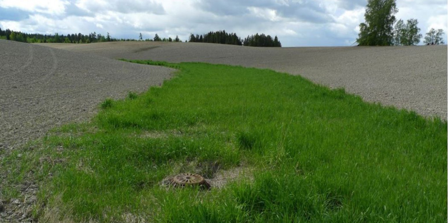
Example of grassed natural waterway in the landscape (Anne-Grete B.Blankenberg)

Grassed waterways (ນໍເວ)

Grasdekte vannveier

ຄຳອະທິບາຍ

Grassed waterways are shallow channels (natural or constructed) with grass cover, used to drain surface runoff from cropland and prevent erosion.

In this documentation we focus on the grassed waterways as a measure to carry surface water down the slope without causing soil erosion. The overland flow can be concentrated in topographic depressions, "thalwegs" in the field. Concentrated runoff in such watercourses can create small rills or even gullies. Vegetation/grass disrupt the water flow, but more importantly to protect the soil from erosive forces.

Purpose/aim: Grassed waterways are important conservation measures managing concentrated flow, especially in agricultural areas: runoff concentrates over grassed areas rather than on bare erodible soil (after tillage). They are intended to reduce runoff velocity and soil erosion by grass roots binding the soil. They also help to enhance infiltration, filtering runoff and contribute to sediment and nutrient deposition.

Establishment/maintenance: Grassed waterways are commonly used in areas where waterways are especially erosion-prone. They are normally sited downslope along natural depressions leading water away from agricultural fields. To control surface runoff, grassed waterways are often combined with inlets for surface water leading runoff to drainage pipes.

According to Regional Environmental Programme (RMP) in Norway, permanent grass cover in topographical depressions should be at least 6 m wide. Grass should be sown in the spring to ensure that it is well established in autumn. The choice of grass species depend on whether there is intention of (for example) using the grass for fodder. The grass can be fertilized or treated by herbicides, since they are located inside the production area. The grass can be harvested to maintain land area for food production and reduce nutrient leakage to the watercourse. Area can be tilled only when renewing the grass cover.

An alternative to grassed waterways is to leave the natural waterways covered in stubble over winter (i.e. unploughed). This measure reduces erosion but will not be as effective as grass cover and will not have the same effect on uptake of nutrients as grass cover waterways, as stubble is dead material.

Efficiency /Impact: The effect of (any) vegetation zones depend on several factors such as the flow properties and the characteristics of the vegetative surface. Significant flow properties are velocity (and hence the slope gradient) and water volume, the particle size and concentration of the sediment in the runoff, and duration and intensity of precipitation. For Norwegian conditions there is also the effect of frozen or unfrozen soil and intensity of snowmelt influence on runoff (surface runoff and infiltration).

Studies of Norwegian conditions indicate that the most relevant factor for function of the vegetation zone is the character of the vegetation (height, robustness, and density), rather than the type of vegetation (Blankenberg & Hougsrud 2010). As the efficiency of vegetation comprises a variety of factors, the implementation of the measures is to a large degree site-specific (Kværnø & Stolte 2012).

The effect of grassed waterways on soil loss has been documented in only a few studies. In Norway, only one study examined the effect of grassed waterways in a small agricultural catchment (26.8 daa or 2.68 ha) in Romerike (Akershus, Viken) and it showed 55% reduction of soil loss (average from 8 years) after implementation of grassed waterways.

Natural / human environment: The information about the technology is based on investigations and/or reports from different part of Norway.
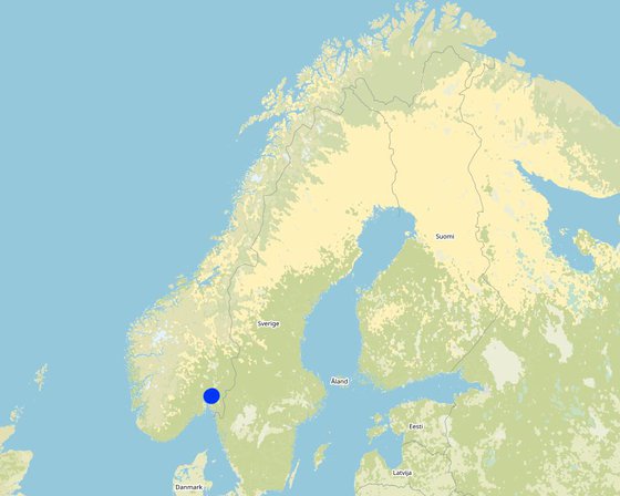
For the purpose of OPTAIN project (https://www.optain.eu/), the technology is further presented in the natural and human environment context of the Kråkstad River catchment - a Norwegian Case Study catchment within OPTAIN project.

The Kråkstad River is mainly situated in Ski municipality in South-Eastern parts of Norway. The river catchment is a western tributary of the Vansjø-Hobøl watercourse, also known as the Morsa watercourse. The Kråkstad River catchment area is c.a 51 km², 43% of which is agricultural land, where mostly cereals are produced on heavy clays soils. The main environmental challenge in the area is water quality (incl. high phosphorus pollution) and soil erosion (incl. riverbank erosion and quick-clay landslides).The Morsa watercourse is a drinking water resource and there are specific environmental regulations for land management followed by subsidies through the Regional Environmental Programme (RMP).

ສະຖານທີ່

ສະຖານທີ່: The Vansjø-Hobøl catchment, Viken county, ນໍເວ

ຈໍານວນ ພື້ນທີ່ ທີ່ໃຊ້ ເຕັກໂນໂລຢີ ທີ່ໄດ້ວິເຄາະ: 10-100 ພຶ້ນທີ່

ການຄັດເລືອກພື້ນທີ່ ທີ່ອີງໃສ່ຂໍ້ມູນທາງພູມີສາດ
  • 10.88435, 59.68235
  • 10.83177, 59.67674
  • 10.89848, 59.69789

ການແຜ່ກະຈາຍຂອງເຕັກໂນໂລຢີ: ແຜ່ຂະຫຍາຍຢ່າງໄວວາໃນພື້ນທີ່ (approx. 0.1-1 ກມ 2)

ຢູ່ໃນເຂດປ່າສະຫງວນທີ່ບໍ?: ບໍ່ແມ່ນ

ວັນທີຂອງການປະຕິບັດ: 10-50 ປີ ຜ່ານມາ

ປະເພດຂອງການນໍາສະເໜີ
Grassed waterway in an agricultural catchment (Anne-Grete Busetch Blankenberg)
Field covered with stubble in topograpic depression (thalweg) (Dominika Krzeminska)

ການໄຈ້ແຍກເຕັກໂນໂລຢີ

ຈຸດປະສົງຕົ້ນຕໍ
  • ປັບປຸງ ການຜະລິດ
  • ຫຼຸດຜ່ອນ, ປ້ອງກັນ, ຟື້ນຟູ ການເຊື່ອມໂຊມຂອງດິນ
  • ການອະນຸລັກ ລະບົບນິເວດ
  • ປົກປັກຮັກສານໍ້າ / ນໍ້າພື້ນທີ່ - ປະສົມປະສານກັບ ເຕັກໂນໂລຢີອື່ນໆ
  • ປົກປັກຮັກສາ / ການປັບປຸງຊີວະນາໆພັນ
  • ຫຼຸດຜ່ອນຄວາມສ່ຽງ ທາງໄພພິບັດທໍາມະຊາດ
  • ປັບຕົວຕໍ່ກັບການປ່ຽນແປງດິນຟ້າອາກາດ / ທີ່ຮ້າຍແຮງ ແລະ ຜົນກະທົບ
  • ຫຼຸດຜ່ອນຜົນກະທົບ ຈາກການປ່ຽນແປງດິນຟ້າອາກາດ
  • ສ້າງຜົນກະທົບ ທາງເສດຖະກິດ ທີ່ເປັນປະໂຫຍດ
  • ສ້າງຜົນກະທົບ ທີ່ເປັນທາງບວກ ໃຫ້ແກ່ສັງຄົມ
ການນໍາໃຊ້ດິນ
ການນຳໃຊ້ທີ່ດິນ ປະສົມພາຍໃນພື້ນທີ່ດຽວກັນ: ບໍ່ແມ່ນ

  • ດິນທີ່ປູກພືດ
    • ການປູກພືດປະຈໍາປີ: ທັນຍາພືດ-ພືດ ອື່ນໆ, small grains
    ຈໍານວນ ລະດູການ ປູກໃນປີໜຶ່ງ: 1
  • ປ່າໄມ້ / ປ່າ
  • ທິດທາງໄຫຼຂອງນໍ້າ, ນໍ້າ,​ ດິນທາມ - ທໍ່ລະບາຍນໍ້າ, ທິດທາງນໍ້າ

ການສະໜອງນໍ້າ
  • ນໍ້າຝົນ
  • ປະສົມປະສານ ກັນລະຫວ່າງ ນໍ້າຝົນ ແລະ ນໍ້າຊົນລະປະທານ
  • ນໍາໃຊ້ ນໍ້າຊົນລະປະທານ ພຽງຢ່າງດຽວ

ຈຸດປະສົງທີ່ກ່ຽວຂ້ອງກັບການເຊື່ອມໂຊມຂອງດິນ
  • ປ້ອງກັນການເຊື່ອມໂຊມຂອງດິນ
  • ຫຼຸດຜ່ອນການເຊື່ອມໂຊມຂອງດິນ
  • ການຟື້ນຟູ / ຟື້ນຟູດິນທີ່ຊຸດໂຊມ
  • ປັບຕົວຕໍ່ການເຊື່ອມໂຊມຂອງດິນ
  • ບໍ່ສາມາດໃຊ້ໄດ້
ການເຊື່ອມໂຊມ ທີ່ຕ້ອງໄດ້ເອົາໃຈໃສ່
  • ດິນເຊາະເຈື່ອນ ໂດຍນໍ້າ - Wt: ການສູນເສຍຊັ້ນໜ້າດິນ / ການເຊາະເຈື່ອນຜິວໜ້າດິນ, Wg: ການເຊາະເຈື່ອນຮ່ອງນ້ຳ / ຫ້ວຍ
  • ການເຊື່ອມໂຊມ ຂອງນໍ້າ - Hp: ຄຸນນະພາບ ຂອງນ້ຳຊັ້ນໜ້າດິນຫຼຸດລົງ
ກຸ່ມການຄຸ້ມຄອງທີ່ດິນແບບຍືນຍົງ
  • ການປັບປຸງດິນ / ພືດຄຸມດິນ
  • ມາດຕະການ ຕັດຂວາງ ກັບຄວາມຄ້ອຍຊັນ
  • ຄວາມຫຼາກຫຼາຍຂອງນໍ້າ ແລະ ການລະບາຍ
ມາດຕະການ ການຄຸ້ມຄອງທີ່ດິນແບບຍືນຍົງ
  • ມາດຕະການ ທາງດ້ານພືດພັນ - V2: ຫຍ້າ ແລະ ພືດສະໝູນໄພທີ່ເປັນໄມ້ຢືນຕົ້ນ

​ເທັກ​ນິກ​ການ​ແຕ້ມ​ຮ​ູບ

​ຂໍ​ກຳ​ນົດ​ທາງ​ເທັກ​ນິກ
Grassed waterways in topographic depressions in the field
Author: Lillian Øygarden

ການຈັດຕັ້ງ ແລະ ບໍາລຸງຮັກສາ: ກິດຈະກໍາ, ວັດຖຸດິບ ແລະ ຄ່າໃຊ້ຈ່າຍ

ການ​ຄຳ​ນວນ​ ປັດ​ໃຈ​ການ​ຜະ​ລິດ ແລະ ຄ່າ​ໃຊ້​ຈ່າຍ
  • ຄິດໄລ່ຄ່າໃຊ້ຈ່າຍ: ຕໍ່ຫົວໜ່ວຍ ທີ່ໄດ້ຈັດຕັ້ງປະຕິບັດ ເຕັກໂນໂລຢີ (ຫົວໜ່ວຍ:length of grassed waterways volume, length: meters)
  • ສະກຸນເງິນທີ່ໃຊ້ສໍາລັບການຄິດໄລ່ຄ່າໃຊ້ຈ່າຍ: NOK
  • ອັດຕາແລກປ່ຽນ (ເປັນເງີນ ໂດລາ): 1 USD = 8.99 NOK
  • ຄ່າແຮງງານສະເລ່ຍ ຂອງການຈ້າງແຮງງານຕໍ່ມື້: c.a. 3000 NOK (it is only the cost of the time assuming 8h work per day, 320-500 NOK/hour/ person. Machinery, equipment, materials not included)
ປັດໄຈທີ່ສໍາຄັນສຸດທີ່​ສົ່ງຜົນກະທົບຕໍ່ຄ່າໃຊ້ຈ່າຍ
The costs of establishment and management of grassed waterways are connected to sowing the area and reduced area for cereal production (in case of cereal production farm). There is no general rule for harvesting. However, if farmers harvest the grass they can get the income. If the grass is not harvested then the production area is reduced. The subsidies should be a compensation for such costs. The cost of the area management is dependent on: - Location (priority areas) - Type of grass - Possibility to use the grass as a fodder Grassed waterways are eligible for subsidies in Regional Environmental Programme (RMP). Within RMP for 2019-2022 the subside level for maintaining grassed waterways was at the level of 30 kr/m in Viken region.
ກິດຈະກໍາການສ້າງຕັ້ງ
  1. Plowing (ໄລຍະເວລາ / ຄວາມຖີ່: before sowing)
  2. Harrowing (ໄລຍະເວລາ / ຄວາມຖີ່: before sowing)
  3. Sowing grass (ໄລຍະເວລາ / ຄວາມຖີ່: in spring)
ກິດຈະກໍາບໍາລຸງຮັກສາ
  1. Harvesting grass (ໄລຍະເວລາ / ຄວາມຖີ່: 2-3 times/yr)
  2. Plowing (ໄລຍະເວລາ / ຄວາມຖີ່: In case the re-establishment is needed)
  3. Harrowing (ໄລຍະເວລາ / ຄວາມຖີ່: In case the re-establishment is needed)
  4. Sowing grass (ໄລຍະເວລາ / ຄວາມຖີ່: In case the re-establishment is needed)

ສະພາບແວດລ້ອມທໍາມະຊາດ

ສະເລ່ຍປະລິມານນໍ້າຝົນປະຈໍາປີ
  • < 250 ມີລິແມັດ
  • 251-500 ມີລິແມັດ
  • 501-750 ມີລິແມັດ
  • 751-1,000 ມີລິແມັດ
  • 1,001-1,500 ມີລິແມັດ
  • 1,501-2,000 ມີລິແມັດ
  • 2,001-3,000 ມີລິແມັດ
  • 3,001-4,000 ມີລິແມັດ
  • > 4,000 ມີລິແມັດ
ເຂດກະສິກໍາ-ສະພາບອາກາດ
  • ຄວາມຊຸ່ມ
  • ເຄີ່ງຄວາມຊຸ່ມ
  • ເຄິ່ງແຫ້ງແລ້ງ
  • ແຫ້ງແລ້ງ
ຂໍ້ມູນຈໍາເພາະກ່ຽວກັບສະພາບອາກາດ
Thermal climate class: temperate
Thermal climate class: boreal
​ຄວາມຄ້ອຍ​ຊັນ
  • ພື້ນທີ່ຮາບພຽງ (0-2%)
  • ອ່ອນ (3-5 %)
  • ປານກາງ (6-10 %)
  • ມ້ວນ (11-15 %)
  • ເນີນ(16-30%)
  • ໍຊັນ (31-60%)
  • ຊັນຫຼາຍ (>60%)
ຮູບແບບຂອງດິນ
  • ພູພຽງ / ທົ່ງພຽງ
  • ສັນພູ
  • ເປີ້ນພູ
  • ເນີນພູ
  • ຕີນພູ
  • ຮ່ອມພູ
ລະດັບຄວາມສູງ
  • 0-100 ແມັດ a.s.l.
  • 101-500 ແມັດ a.s.l.
  • 501-1,000 ແມັດ a.s.l.
  • 1,001-1,500 ແມັດ a.s.l.
  • 1,501-2,000 ແມັດ a.s.l.
  • 2,001-2,500 ແມັດ a.s.l.
  • 2,501-3,000 ແມັດ a.s.l.
  • 3,001-4,000 ແມັດ a.s.l.
  • > 4,000 ແມັດ a.s.l.
ເຕັກໂນໂລຢີໄດ້ຖືກນໍາໃຊ້ໃນ
  • ລັກສະນະສວດ
  • ລັກສະນະກີ່ວ
  • ບໍ່ກ່ຽວຂ້ອງ
ຄວາມເລິກຂອງດິນ
  • ຕື້ນຫຼາຍ (0-20 ຊັງຕີແມັດ)
  • ຕື້ນ (21-50 ຊຕມ)
  • ເລີກປານກາງ (51-80 ຊຕມ)
  • ເລິກ (81-120 ຊມ)
  • ເລິກຫຼາຍ (> 120 cm)
ໂຄງສ້າງຂອງດິນ (ເທີງໜ້າດິນ)
  • ຫຍາບ / ເບົາ (ດິນຊາຍ)
  • ປານກາງ (ດິນໜຽວ, ດິນໂຄນ)
  • ບາງລະອຽດ / ໜັກ (ໜຽວ)
ໂຄງສ້າງຂອງດິນ (ເລິກລົງ 20 ຊັງຕີແມັດ)
  • ຫຍາບ / ເບົາ (ດິນຊາຍ)
  • ປານກາງ (ດິນໜຽວ, ດິນໂຄນ)
  • ບາງລະອຽດ / ໜັກ (ໜຽວ)
ທາດອິນຊີຢູ່ເທິງໜ້າດິນ
  • ສູງ (> 3 %)
  • ປານກາງ (1-3 %)
  • ຕໍາ່ (<1 %)
​ນ້ຳ​ໃຕ້​ດິນ
  • ເທິງຊັ້ນໜ້າດິນ
  • < 5 ແມັດ
  • 5-50 ແມັດ
  • > 50 ແມັດ
ມີນໍ້າໜ້າດິນ
  • ເກີນ
  • ດີ
  • ປານກາງ
  • ທຸກຍາກ / ບໍ່ມີ
ຄຸນນະພາບນໍ້າ (ການຮັກສາ)
  • ມີນໍ້າດື່ມ
  • ບໍ່ມີນໍ້າດື່ມ (ຮຽກຮ້ອງໃຫ້ມີການບຳບັດນ້ຳ)
  • ນຳໃຊ້ເຂົ້າໃນການຜະລິດກະສິກໍາພຽງຢ່າງດຽງ (ຊົນລະປະທານ)
  • ຜິດປົກກະຕິ
ຄຸນນະພາບນ້ຳ ໝາຍເຖີງ: ທັງນ້ຳໃຕ້ດິນ ແລະ ນ້ຳໜ້າດິນ
ດິນ​ເຄັມ​ເປັນ​ບັນ​ຫາ​ບໍ່?
  • ແມ່ນ
  • ບໍ່ແມ່ນ

ການເກີດນໍ້າຖ້ວມ
  • ແມ່ນ
  • ບໍ່ແມ່ນ
ຄວາມຫຼາກຫຼາຍຂອງຊະນິດ
  • ສູງ
  • ປານກາງ
  • ຕໍ່າ
ຄວາມຫຼາກຫຼາຍຂອງສິ່ງທີ່ມີຊີວິດ
  • ສູງ
  • ປານກາງ
  • ຕໍ່າ

ຄຸນລັກສະນະຂອງຜູ້ນຳໃຊ້ທີ່ດິນການນໍາໃຊ້ເຕັກໂນໂລຢີ

ການວາງແນວທາງຕະຫຼາດ
  • ກຸ້ມຕົນເອງ (ພໍພຽງ)
  • ປະສົມປົນເປ( ກຸ້ມຕົນເອງ/ເປັນສິນຄ້າ)
  • ການຄ້າ / ຕະຫຼາດ
ລາຍຮັບທີ່ໄດ້ມາຈາກກິດຈະກໍາອື່ນໆ ທີ່ບໍ່ແມ່ນການຜະລິດກະສິກໍາ
  • ໜ້ອຍກ່ວາ 10 % ຂອງລາຍຮັບທັງໝົດ
  • 10-50 % ຂອງລາຍຮັບທັງໝົດ
  • > 50 % ຂອງລາຍຮັບທັງໝົດ
ລະດັບຄວາມຮັ່ງມີ
  • ທຸກ​ຍາກ​ຫຼາຍ
  • ທຸກຍາກ
  • ສະເລ່ຍ
  • ຮັ່ງມີ
  • ຮັ່ງມີຫຼາຍ
ລະດັບຂອງການຫັນເປັນກົນຈັກ
  • ການໃຊ້ແຮງງານຄົນ
  • ສັດລາກແກ່
  • ເຄື່ອງກົນຈັກ
ຢູ່​ປະ​ຈຳ ຫຼື ເລ​ລ້ອນ
  • ບໍ່ເຄື່ອນໄຫວ
  • ແບບເຄີ່ງຂັງ-ເຄີ່ງປ່ອຍ
  • ແບບປ່ອຍຕາມທຳມະຊາດ
ບຸກຄົນ ຫຼື ກຸ່ມ
  • ບຸກຄົນ / ຄົວເຮືອນ
  • ກຸ່ມ / ຊຸມຊົນ
  • ການຮ່ວມມື
  • ການຈ້າງງານ (ບໍລິສັດ, ອົງການ ລັດຖະບານ)
ເພດ
  • ຜູ້ຍິງ
  • ຜູ້ຊາຍ
ອາ​ຍຸ
  • ເດັກນ້ອຍ
  • ຊາວໜຸ່ມ
  • ໄວ​ກາງ​ຄົນ
  • ຜູ້ສູງອາຍຸ
ເຂດພື້ນທີ່ການນໍາໃຊ້ຕໍ່ຄົວເຮືອນ
  • <0.5 ເຮັກຕາ
  • 0.5-1 ເຮັກຕາ
  • 1-2 ເຮັກຕາ
  • 2-5 ເຮັກຕາ
  • 5-15 ເຮັກຕາ
  • 15-50 ເຮັກຕາ
  • 50-100 ເຮັກຕາ
  • 100-500 ເຮັກຕາ
  • 500-1,000 ເຮັກຕາ
  • 1,000-10,000 ເຮັກຕາ
  • > 10,000 ເຮັກຕາ
ຂະໜາດ
  • ຂະໜາດນ້ອຍ
  • ຂະໜາດກາງ
  • ຂະໜາດໃຫຍ່
ເຈົ້າຂອງທີ່ດິນ
  • ລັດ
  • ບໍລິສັດ
  • ຊຸມຊົນ / ບ້ານ
  • ກຸ່ມ
  • ບຸກຄົນ, ບໍ່ມີຕໍາແໜ່ງ
  • ບຸກຄົນ, ທີ່ມີຕໍາແໜ່ງ
ສິດທິການນໍາໃຊ້ທີ່ດິນ
  • ເປີດກວ້າງ (ບໍ່ມີການຈັດຕັ້ງ)
  • ຊຸມຊົນ (ທີ່ມີການຈັດຕັ້ງ)
  • ເຊົ່າ
  • ບຸກຄົນ
ສິດທິການນໍາໃຊ້ນໍ້າ
  • ເປີດກວ້າງ (ບໍ່ມີການຈັດຕັ້ງ)
  • ຊຸມຊົນ (ທີ່ມີການຈັດຕັ້ງ)
  • ເຊົ່າ
  • ບຸກຄົນ
ການເຂົ້າເຖິງການບໍລິການ ແລະ ພື້ນຖານໂຄງລ່າງ
ສຸຂະພາບ

ທຸກຍາກ
ດີ
ການສຶກສາ

ທຸກຍາກ
ດີ
ການຊ່ວຍເຫຼືອ ດ້ານວິຊາການ

ທຸກຍາກ
ດີ
ການຈ້າງງານ (ຕົວຢ່າງ, ການເຮັດກິດຈະກໍາອື່ນ ທີ່ບໍ່ແມ່ນ ການຜະລິດກະສິກໍາ)

ທຸກຍາກ
ດີ
ຕະຫຼາດ

ທຸກຍາກ
ດີ
ພະລັງງານ

ທຸກຍາກ
ດີ
ຖະໜົນຫົນທາງ ແລະ ການຂົນສົ່ງ

ທຸກຍາກ
ດີ
ການດື່ມນໍ້າ ແລະ ສຸຂາພິບານ

ທຸກຍາກ
ດີ
ການ​ບໍ​ລິ​ການ​ ທາງ​ດ້ານ​ການ​ເງິນ

ທຸກຍາກ
ດີ

ຜົນກະທົບ

ຜົນກະທົບທາງສັງຄົມ ແລະ ເສດຖະກິດ
ຜົນຜະລິດ
ຫຼຸດລົງ
ເພີ່ມຂຶ້ນ


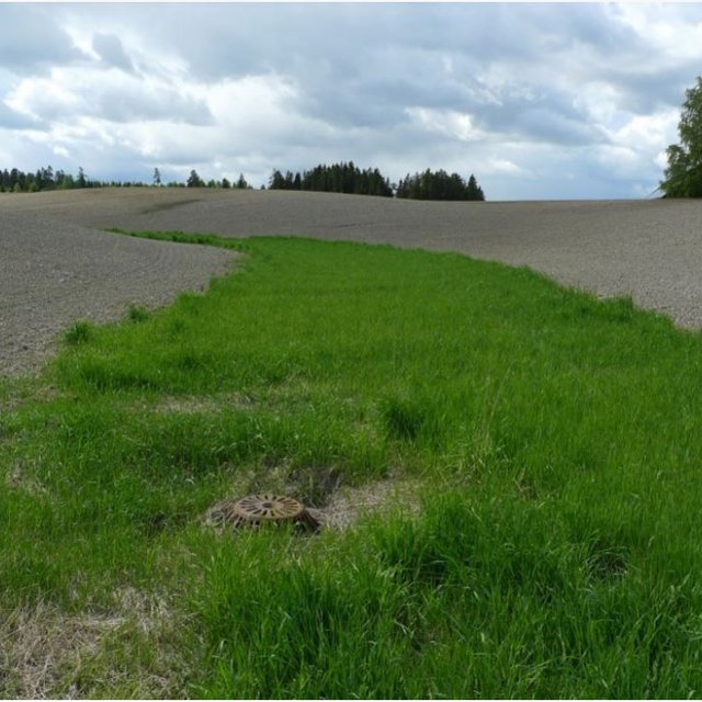
Land removed from crop production. If harvested as fodder - then contribute positive to income.

ລາຍຮັບ ຈາກການຜະລີດ
ຫຼຸດລົງ
ເພີ່ມຂຶ້ນ

ຜົນກະທົບທາງສັງຄົມ ວັດທະນະທໍາ
ຜົນກະທົບຕໍ່ລະບົບນິເວດ
ປະລິມານນໍ້າ
ຫຼຸດລົງ
ເພີ່ມຂຶ້ນ


Enhanced infiltration

ຄຸນນະພາບນໍ້າ
ຫຼຸດລົງ
ເພີ່ມຂຶ້ນ


Ideally less sediment (and phosphorus) is transported to the surface waters (rivers, lakes), and consequently water quality is increased.

ການໄຫຼ ຂອງນໍ້າໜ້າດິນ
ເພີ່ມຂຶ້ນ
ຫຼຸດລົງ


Due to enhanced infiltration in the grassed areas and reduction of surface runoff velocity

ການລະບາຍນໍ້າ
ຫຼຸດຜ່ອນ
ປັບປຸງ


When combined with inlet to the drainage system

ການປົກຄຸມຂອງດິນ
ຫຼຸດຜ່ອນ
ປັບປຸງ

ການສູນເສຍດິນ
ເພີ່ມຂຶ້ນ
ຫຼຸດລົງ

ການປົກຫຸ້ມຂອງພືດ
ຫຼຸດລົງ
ເພີ່ມຂຶ້ນ

ການເຊາະເຈື່ອນຂອງດິນ / ຊາກສະລະຫະພັງ
ເພີ່ມຂຶ້ນ
ຫຼຸດລົງ

ຜົນກະທົບນອກ​ສະ​ຖານ​ທີ່
ມົນລະພິດ ທາງນໍ້າ / ນໍ້າໄຕ້ດິນ
ເພີ່ມຂຶ້ນ
ຫຼຸດຜ່ອນ

ຄວາມອາດສາມາດ ໃນການກີດຂວາງ / ການກັ່ນຕອງ (ໂດຍດິນ, ພືດພັນ, ດິນທາມ)
ຫຼຸດຜ່ອນ
ປັບປຸງ

ການວິເຄາະຕົ້ນທຶນ ແລະ ຜົນປະໂຫຍດ

ຜົນປະໂຫຍດເມື່ອທຽບກັບຄ່າໃຊ້ຈ່າຍໃນການສ້າງຕັ້ງ
ຜົນຕອບແທນ ໃນໄລຍະສັ້ນ
ຜົນກະທົບທາງລົບຫຼາຍ
ຜົນກະທົບທາງບວກຫຼາຍ

ຜົນຕອບແທນ ໃນໄລຍະຍາວ
ຜົນກະທົບທາງລົບຫຼາຍ
ຜົນກະທົບທາງບວກຫຼາຍ

ຜົນປະໂຫຍດເມື່ອທຽບກັບຄ່າໃຊ້ຈ່າຍບໍາລຸງຮັກສາ
ຜົນຕອບແທນ ໃນໄລຍະສັ້ນ
ຜົນກະທົບທາງລົບຫຼາຍ
ຜົນກະທົບທາງບວກຫຼາຍ

ຜົນຕອບແທນ ໃນໄລຍະຍາວ
ຜົນກະທົບທາງລົບຫຼາຍ
ຜົນກະທົບທາງບວກຫຼາຍ

ການປ່ຽນແປງສະພາບດິນຟ້າອາກາດ

ການປ່ຽນແປງດິນຟ້າອາກາດ ເທື່ອລະກ້າວ
ອຸນຫະພູມປະຈໍາປີ ເພີ່ມຂື້ນ

ບໍ່ດີຈັກຢ່າງ
ດີຫຼາຍ
ປະລິມານນໍ້າຝົນປະຈໍາປີ ເພີ່ມຂື້ນ

ບໍ່ດີຈັກຢ່າງ
ດີຫຼາຍ
ອາກາດ ທີ່ກ່ຽວພັນກັບຄວາມຮຸນແຮງ (ໄພພິບັດທາງທໍາມະຊາດ)
ພະຍຸຝົນ

ບໍ່ດີຈັກຢ່າງ
ດີຫຼາຍ
ໂດຍທົ່ວໄປ (ແມ່ນໍ້າ) ນໍ້າຖ້ວມ

ບໍ່ດີຈັກຢ່າງ
ດີຫຼາຍ

ການຍອມຮັບ ແລະ ການປັບຕົວ

ອັດຕາສ່ວນຂອງຜູ້ຊົມໃຊ້ທີ່ດິນໃນເຂດພື້ນທີ່ທີ່ໄດ້ຮັບຮອງເອົາເຕັກໂນໂລຢີ
  • ກໍລະນີດຽວ / ການທົດລອງ
  • 1-10%
  • 11-50%
  • > 50%
ທັງໝົດນັ້ນ ມີໃຜແດ່ທີ່ສາມາດປັບຕົວຕໍ່ເຕັກໂນໂລຢີ,​ ມີຈັກຄົນທີ່ໄດ້ຮັບການກະຕຸກຊຸກຍູ້ ແລະ ອຸປະກອນ?
  • 0-10%
  • 11-50%
  • 51-90%
  • 91-100%
ໄດ້ມີການດັດແປງເຕັກໂນໂລຢີ ເພື່ອປັບໃຫ້ເຂົ້າກັບເງື່ອນໄຂການປ່ຽນແປງບໍ່?
  • ແມ່ນ
  • ບໍ່ແມ່ນ
ໄດ້ປ່ຽນແປງເງື່ອນໄຂຫຍັງແດ່?
  • ການປ່ຽນແປງດິນຟ້າອາກາດ / ຮ້າຍແຮງ
  • ຕະຫຼາດມີການປ່ຽນແປງ
  • ມີແຮງງານ (ຕົວຢ່າງ, ເນື່ອງຈາກການເຄື່ອນຍ້າຍແຮງງານ)

ບົດສະຫຼຸບ ແລະ ບົດຮຽນທີ່ໄດ້ຮັບ

ຄວາມເຂັ້ມແຂງ: ທັດສະນະມູມມອງ ຂອງຜູ້ນໍາໃຊ້ທີ່ດິນ
  • Less soil loss
ຄວາມເຂັ້ມແຂງ: ທັດສະນະມຸມມອງ ຂອງຜູ້ປ້ອນຂໍ້ມູນເອງ
  • Reduced erosion
  • Improved water quality
ຈຸດອ່ອນ / ຂໍ້ເສຍ / ຄວາມສ່ຽງ: ທັດສະນະມູມມອງ ຂອງຜູ້ນໍາໃຊ້ທີ່ດິນວິທີການແກ້ໄຂແນວໃດ
  • Land must be removed from crop production.
  • Some maintenance is needed periodically so that erosion does not occur along the edges.
ຈຸດອ່ອນ / ຂໍ້ເສຍ / ຄວາມສ່ຽງ: ທັດສະນະມຸມມອງ ຂອງຜູ້ປ້ອນຂໍ້ມູນເອງວິທີການແກ້ໄຂແນວໃດ
  • No enough research about efficiency of Technology More research

ເອກກະສານອ້າງອີງ

ການລວບລວມ
  • Dominika Krzeminska
Editors
  • Lillian Øygarden
ການທົບທວນຄືນ
  • Rima Mekdaschi Studer
  • William Critchley
  • Tatenda Lemann
ວັນທີຂອງການປະຕິບັດ: Feb. 7, 2022
ປັບປຸງລ່າສຸດ: Feb. 3, 2023
ບຸກຄົນທີ່ສໍາຄັນ
ການບັນຍາຍລາຍລະອຽດ ໃນຖານຂໍ້ມູນ ຂອງ WOCAT
ຂໍ້ມູນການເຊື່ອມໂຍງຂໍ້ມູນການຄຸ້ມຄອງການນໍາໃຊ້ດິນແບບຍືນຍົງ
ເອກກະສານ ແມ່ນໄດ້ອໍານວຍຄວາມສະດວກໂດຍ
ສະຖາບັນ ​ໂຄງ​ການ
ການອ້າງອີງທີ່ສໍາຄັນ
  • Kværnø S., Øygarden L., Bechmann M., Barneveld R. 2020. Tiltak mot erosjon på jordbruksareal. NIBIO POP 6(38)2020: NIBIO website
  • Blankenberg, A-G.B. and Skarbøvik E. 2019. Vegetasjon som miljøtiltak i jordbruket: Varianter, tilskudd og lovverk.NIBIO POP 5(10) 2019: NIBIO website
  • Øygarden L. 2003. Rill and gully development during an extreme winter runoff event in Norway. CATENA 50: CATENA
ເຊື່ອມໂຍງກັບ ຂໍ້ມູນຕ່າງໆ ທີ່ກ່ຽວຂ້ອງທີ່ມີ
This work is licensed under Creative Commons Attribution-NonCommercial-ShareaAlike 4.0 International