Pasture inclination used for developing grazing plan [ຕາຈິກິສະຕານ]
- ການສ້າງ:
- ປັບປູງ:
- ຜູ້ສັງລວມຂໍ້ມູນ: Askarsho Zevarshoev
- ບັນນາທິການ: –
- ຜູ້ທົບທວນຄືນ: Maximilian Knoll, Yacime Khadraoui
Накшаи чарондани чорво дар чарогох аз руи мавкеи чойгиршави (офтобруя ва сояру)
approaches_3474 - ຕາຈິກິສະຕານ
ເບິ່ງພາກສ່ວນ
ຂະຫຍາຍທັງໝົດ ຍຸບທັງໝົດ1. ຂໍ້ມູນທົ່ວໄປ
1.2 ລາຍລະອຽດ ການຕິດຕໍ່ ຂອງບຸກຄົນທີ່ຊັບພະຍາກອນ ແລະ ສະຖາບັນ ການມີສ່ວນຮ່ວມ ໃນການປະເມີນຜົນ ແລະ ເອກະສານ ຂອງວິທີທາງ
ຜູ້ຊ່ຽວຊານ ດ້ານການຄຸ້ມຄອງ ທີ່ດິນແບບຍືນຍົງ:
ຊື່ຂອງໂຄງການ ທີ່ອໍານວຍຄວາມສະດວກ ໃນການສ້າງເອກກະສານ ຫຼື ປະເມີນດ້ານແນວທາງ (ຖ້າກ່ຽວຂ້ອງ)
Environmental Land Management and Rural Livelihood Projectຊື່ຂອງ ສະຖາບັນການຈັດຕັ້ງ ທີ່ອໍານວຍຄວາມສະດວກ ໃນການສ້າງເອກກະສານ ຫຼື ປະເມີນແນວທາງ (ຖ້າກ່ຽວຂ້ອງ)
Aga Khan Foundation (Aga Khan Foundation) - ສະວິດເຊີແລນ1.3 ເງື່ອນໄຂ ຂອງການນໍາໃຊ້ເອກກະສານຂໍ້ມູນ ຂອງ WOCAT
ເມື່ອໃດທີ່ໄດ້ສັງລວມຂໍ້ມູນ (ຢູ່ພາກສະໜາມ)?
20/07/2016
ຜູ້ສັງລວມ ແລະ ບັນດາຜູ້ຕອບແບບສອບຖາມ ຍອມຮັບໃນເງື່ອນໄຂ ການນໍາໃຊ້ຂໍ້ມູນເອກະສານ ທີ່ສ້າງຂື້ນ ໂດຍຜ່ານ ອົງການ WOCAT:
ແມ່ນ
1.4 ເອກະສານອ້າງອີງ (ຫຼາຍ) ກັບແບບສອບຖາມ (ຫຼາຍ) ເຕັກໂນໂລຢີ ຂອງດ້ານການຄຸ້ມຄອງ ດິນແບບຍືນຍົງ

Технология управлениия пастбищами в условиях Западного Памира [ຕາຈິກິສະຕານ]
Управление пастбищных угодий путем внедрения новой техники пастбищеоборота с учетом емкости пастбища
- ຜູ້ສັງລວມຂໍ້ມູນ: Aslam Qadamov
2. ພັນລະນາ ແນວທາງການຄຸ້ມຄອງນໍາໃຊ້ດິນແບບຍືນຍົງ
2.1 ການອະທິບາຍ ໂດຍຫຍໍ້ ຂອງວິທີທາງ
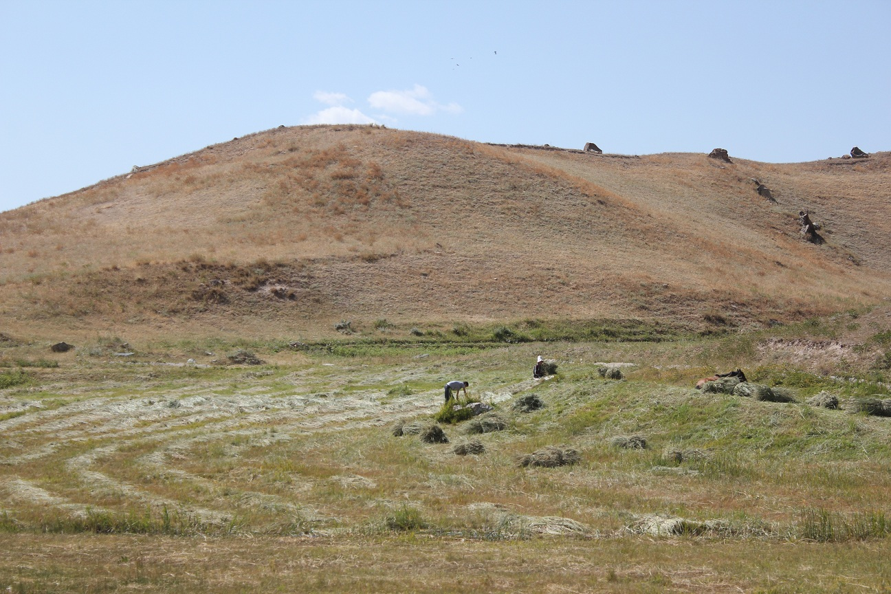
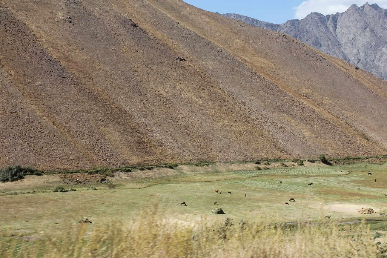
In this approach the inclination of pasture land and its effect on the spread of sun and shadow is used to identify different periods for grazing. This simple approach will raise awareness and provides biological aspects in pasture management. In this approach the vegetation cover of the pasture is linked to the position of the sun. This is specific to mountain areas, where in one location vegetation periods can differ in two spots although they are in the same location.
2.2 ການອະທິບາຍ ລາຍລະອຽດ ຂອງວິທີທາງ
ການອະທິບາຍ ລາຍລະອຽດ ຂອງວິທີທາງ:
Considering pasture's geographical location and its inclination to the sun is identified as an important element of devoloping rotational grazing plans. Because of the mountainous geography of the area, within certain pasture areas one part can be sun inclined and the other is shadowed. This is effecting the vegetation growing process, since on the sun inclined part the vegetation is growing faster compared to the other where sun is reaching later. Communities in the past did not take this into consideration and grazed in both areas at the same time. This leads to degradation in the areas where vegetation did not grow properly. On the other side if the areas inclined to the sun are not grazed in time they dry up.
The main objective of this approach is to apply an ecosystem based adaptation approach in pasture use, with vegetative periods for different areas and locations. By applying this approach communities will be enabled to organize grazing plans correctly and to prevent pasture degradation.
The implementation period will start from the planing phase up to the implementation of the pasture plan. Mainly livestock owners and the PUU management is involved in the implementation of this approach. Pasture users will be mobilized according to the grazing plan, in which part of the pasture when to graze with taking into consideration the position to the sun. Beside land users, the local government is also involved to ensure sustainable use of this approach as one of the techniques in prevention of pasture degradation.
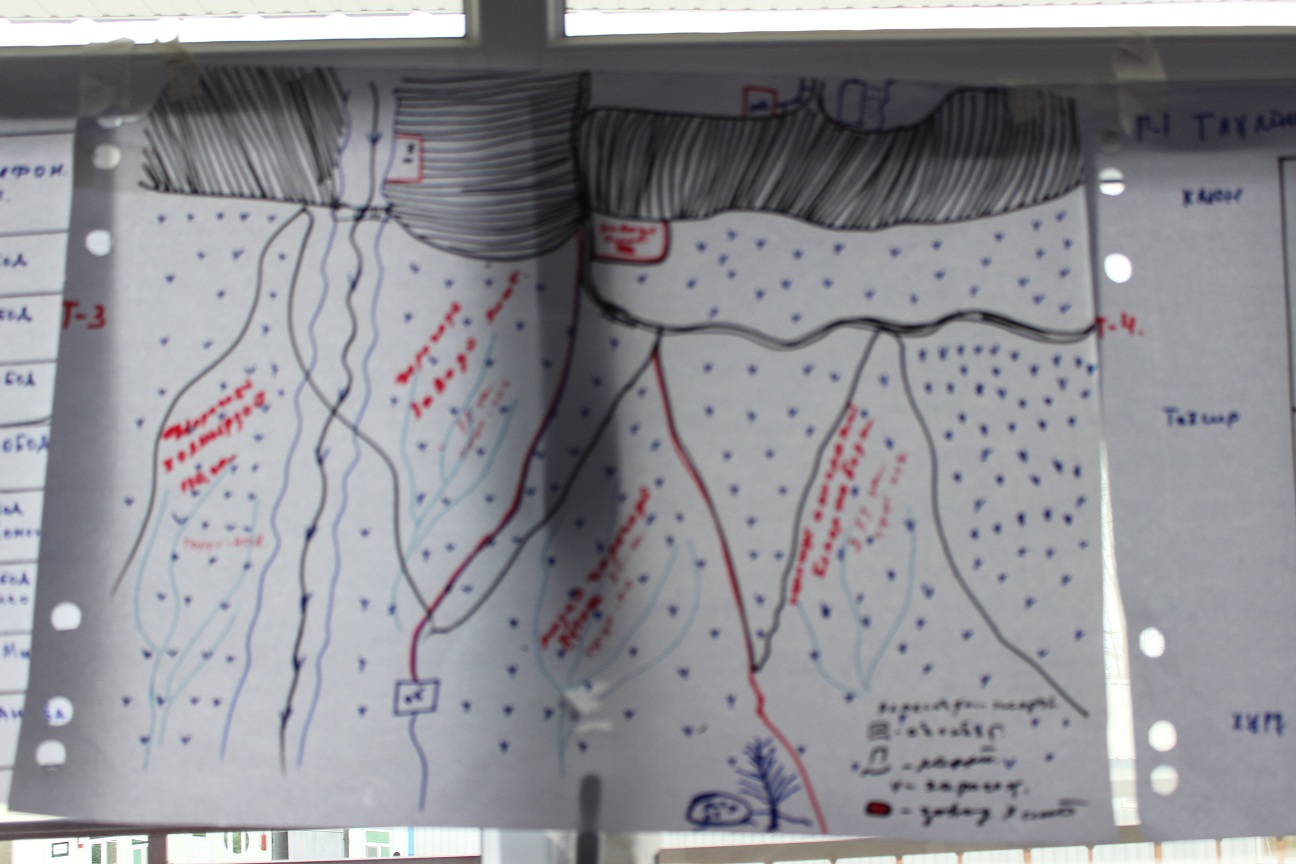
Based on the existing traditional community knowledge and experiences the communities identify the geographical location. Based on this knowledge while developing the grazing plan for the year in a meeting in a participatory manner they do community resource mapping, where the location of resources is provided. After preparing the community resource maps, especially with focus on pasture resources they mark the plots according to assigned attributes. Based on these attributes, where the important features is pasture exposition, a timeframe for grazing for each plot is set up.
Livestock owners are very much in favor to implement this approach as a simple method to prevent degradation and raising awareness on importance of periodic and systematic use of pasture lands. It was not well perceived well by some individual livestock owners, who abused the absence of grazing plans and benefited from early use of grazing without considering the degradation of the pastures.
2.3 ຮູບພາບຂອງແນວທາງ
ສື່ຮູບພາບ
ຂໍ້ສັງເກດໂດຍທົ່ວໄປກ່ຽວກັບການຮູບພາບ:
Community resource mapping with using land use system approach and distribution of the pasture lands into different plots according to different attributes.
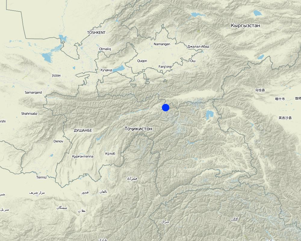
2.5 ປະເທດ / ເຂດ / ສະຖານທີ່ບ່ອນທີ່ແນວທາງໄດ້ຖືກນໍາໃຊ້
ປະເທດ:
ຕາຈິກິສະຕານ
ພາກພື້ນ / ລັດ / ແຂວງ:
Central Asia/Tajikistan/Rasht Valley
Map
×2.6 ວັນທີເລີ່ມຕົ້ນ ແລະ ສິ້ນສຸດ ການຈັດຕັ້ງປະຕີບັດ ວິທີທາງ
ຖ້າຫາກບໍ່ຮູ້ຈັກປີທີ່ແນ່ນອນ, ໃຫ້ປະມານຄາດຄະເນ ເອົາມື້ທີ່ໄດ້ເລີ່ມຈັດຕັ້ງປະຕິບັດ ວິທີທາງ:
10-50 ປີ ຜ່ານມາ
ຄວາມຄິດເຫັນ:
Traditionally community used this approach based on the knowledge on pasture management coming to them from their ancestors.
2.7 ປະເພດຂອງແນວທາງ
- ພື້ນເມືອງ / ທ້ອງຖີ່ນ
2.8 ເປົ້າໝາຍ / ຈຸດປະສົງຫຼັກ ຂອງການຈັດຕັ້ງປະຕິບັດ ວິທີທາງ
The main aim of this approach is to set up clear timeframes for grazing in different plots of the pasture. When the pasture plot is sun inclined this will define the grazing time earlier, because the vegetation grows faster and bigger. On the other hand the pasture plot which is in the shadowed part is grazed later after winter, because the grass should reach a certain height before grazing.
2.9 ເງື່ອນໄຂອໍານວຍ ຫຼື ຂັດຂວາງການປະຕິບັດຂອງເຕັກໂນໂລຢີ / ເຕັກໂນໂລຢີການນໍາໃຊ້ຕາມແນວທາງ
ສັງຄົມ / ວັດທະນະທໍາ / ມາດຕະຖານ ແລະ ຄຸນຄ່າທາງສາສະໜາ
- ອໍານວຍ
Since the beginning traditional institute based on traditional knowledge used to apply this approach.
ມີຄວາມສາມາດ / ເຂັ້າເຖິງຊັບພະຍາກອນດ້ານການເງິນ ແລະ ການບໍລິການ
- ອໍານວຍ
No financial resource is required to apply this approach. It is purely based on the management techniques and depend on the organizational capacity of the communities.
ການກໍ່ຕັ້ງສະຖາບັນ
- ອໍານວຍ
Traditionally community based organizations exist, which were responsible for management of community resource, including pasture lands. Nowadays, based on this knowledge community in their newly established Pasture User Unions apply this approach.
ກ່ຽວກັບກົດໝາຍ (ສິດນໍາໃຊ້ດິນ, ສິດນໍາໃຊ້ນໍ້າ)
- ອໍານວຍ
No legal framework is required for this approach.
ຄວາມຮູ້ກ່ຽວກັບການຄຸ້ມຄອງ ທີ່ດິນແບບຍືນຍົງ, ການເຂົ້າເຖິງການສະໜັບສະໜູນ ທາງດ້ານວິຊາການ
- ອໍານວຍ
Community members usually inherit this kind of traditional practices from their ancestors.
3. ການມີສ່ວນຮ່ວມ ແລະ ບົດບາດຂອງພາກສ່ວນທີ່ກ່ຽວຂ້ອງທີ່ໄດ້ມີສ່ວນຮ່ວມ
3.1 ຜູ້ມີສ່ວນຮ່ວມ ໃນວິທີທາງ ແລະ ພາລະບົດບາດ ຂອງເຂົາເຈົ້າ
- ຜູ້ນໍາໃຊ້ດິນໃນທ້ອງຖິ່ນ / ຊຸມຊົນທ້ອງຖິ່ນ
livestock owners
People traditionally use this approach as a limiting factor to plan for grazing and this approach is also incorporated into the community pasture plan.
- ອົງການຈັດຕັ້ງ ພາຍໃນຊຸມຊົນ
village organizations
In those communities, where official legal structure is not established, community based organization still use this approach as traditional practices inherited from previous generation.
3.2 ການມີສ່ວນຮ່ວມຂອງຜູ້ນໍາໃຊ້ທີ່ດິນໃນທ້ອງຖິ່ນ / ຊຸມຊົນທ້ອງຖິ່ນໃນໄລຍະທີ່ແຕກຕ່າງກັນຂອງແນວທາງ
| ການລວບລວມ ເອົາຜູ້ນໍາໃຊ້ດິນ ໃນທ້ອງຖິ່ນ / ຊຸມຊົນທ້ອງຖິ່ນ | ໃຫ້ລະບຸ ຜູ້ໃດທີ່ມີສ່ວນຮ່ວມ ໃນແຕ່ລະກິດຈະກໍາ? | |
|---|---|---|
| ການເລີ່ມຕົ້ນ / ແຮງຈູງໃຈ | ການນໍາໃໍຊ້ເອງ | Land users and their community structure is traditionally aware of this approach and consider it in their planning process. |
| ການວາງແຜນ | ການນໍາໃໍຊ້ເອງ | Once a community initiates its pasture plan they take this approach into consideration. |
| ການປະຕິບັດ | ການນໍາໃໍຊ້ເອງ | The plan is developed in a participatory way with involvement of all stakeholders and agreed on. The grazing location within different timeframe is implemented by the responsible person according to the plan. |
| ຕິດຕາມກວດກາ / ການປະເມີນຜົນ | ການນໍາໃໍຊ້ເອງ | Community leaders or PUUs management assign responsible people to follow up on the approved grazing plan and follow up on the progress by reporting to them. |
3.4 ການຕັດສິນໃຈກ່ຽວກັບການຄັດເລືອກເຕັກໂນໂລຢີຂອງການຄຸ້ມຄອງທີ່ດິນແບບຍືນຍົງ / ເຕັກໂນໂລຢີ
ລະບຸ ຄົນທີ່ຕັດສິນໃຈ ກ່ຽວກັບການຄັດເລືອກຂອງ ເຕັກໂນໂລຢີ / ເຕັກໂນໂລຢີ ຈະໄດ້ຮັບການປະຕິບັດ:
- ຜູ້ນໍາໃຊ້ດິນຜູ້ດຽວ (ການລິເລີ່ມດ້ວຍຕົນເອງ)
ອະທິບາຍ:
This is a specific grographycally bound approach, where land users themselves take initiative.
Specify on what basis decisions were made:
- ປະສົບການສ່ວນບຸກຄົນ ແລະ ຄວາມຄິດເຫັນ (ທີ່ບໍ່ເປັນເອກກະສານ)
4. ການສະໜັບສະໜູນທາງດ້ານວິຊາການ, ການສ້າງຄວາມສາມາດ, ແລະ ການຈັດການຄວາມຮູ້.
4.1 ການສ້າງຄວາມສາມາດ / ການຝຶກອົບຮົມ
ຜູ້ນໍາໃຊ້ທີ່ດິນ ຫຼື ພາກສ່ວນກ່ຽວຂ້ອງອື່ນໆ ໄດ້ຮັບການຝຶກອົບຮົມບໍ່?
ບໍ່ແມ່ນ
4.2 ການບໍລິການໃຫ້ຄໍາປຶກສາ
ເຮັດຜູ້ໃຊ້ທີ່ດິນມີການເຂົ້າເຖິງການບໍລິການໃຫ້ຄໍາປຶກສາ?
ບໍ່ແມ່ນ
4.3 ສະຖາບັນການສ້າງຄວາມເຂັ້ມແຂງ (ການພັດທະນາອົງການຈັດຕັ້ງ)
ສະຖາບັນ ໄດ້ຮັບການສ້າງຕັ້ງຂື້ນ ຫຼື ໄດ້ຮັບການສ້າງຄວາມເຂັ້ມແຂງ ໂດຍການຈັດຕັ້ງປະຕິບັດ ວິທີທາງບໍ່?
- ບໍ່ມີ
4.4 ຕິດຕາມກວດກາ ແລະ ປະເມີນຜົນ
ການຈັດຕັ້ງປະຕິບັດ ວິທີທາງ ໄດ້ມີການປະເມີນຜົນ ແລະ ຕິດຕາມບໍ?
ບໍ່ແມ່ນ
ຄວາມຄິດເຫັນ:
Communities themselves follow up according to their plan.
4.5 ການຄົ້ນຄວ້າ
ນີ້້ແມ່ນສ່ວນໜຶ່ງ ການຄົ້ນຄວ້າ ຂອງວິທີທາງບໍ່?
ບໍ່ແມ່ນ
5. ການສະໜັບສະໜູນທາງດ້ານການເງິນ ແລະ ອຸປະກອນຈາກພາຍນອກ
5.1 ງົບປະມານປະຈໍາປີ ສໍາລັບວິທີທາງ ຂອງການຄຸ້ມຄອງ ທີ່ດິນແບບຍືນຍົງ
ຄໍາເຫັນ (ຕົວຢ່າງ: ແຫຼ່ງຂໍ້ມູນຫຼັກ ຂອງການສະໜອງທຶນ / ຜູ້ໃຫ້ທຶນທີ່ສໍາຄັນ):
no special budget is required to implement this approach
5.2 ການສະໜັບສະໜູນ ທາງດ້ານການເງິນ / ອຸປະກອນ ສະໜອງໃຫ້ແກ່ຜູ້ນໍາທີ່ດິນ
ຜູ້ນໍາໃຊ້ດິນ ໄດ້ຮັບການສະໜັບສະໜູນ ທາງດ້ານ ການເງິນ / ອຸປະກອນ ໃນການຈັດຕັ້ງປະຕິບັດ ເຕັກໂນໂລຢີບໍ?
ບໍ່ແມ່ນ
5.3 ເງິນສົມທົບສໍາລັບການນໍາໃຊ້ສະເພາະປັດໃຈຂາເຂົ້າໃນການຜະລີດກະສິກໍາ (ລວມທັງແຮງງານ)
- ບໍ່ມີ
ຖ້າແຮງງານ ຂອງຜູ້ນໍາໃຊ້ດິນ ໄດ້ຮັບການສະໜັບສະໜູນ ປັດໃຈຂາເຂົ້າ, ແມ່ນບໍ່:
- ການອາສາ
5.4 ສິນເຊື່ອ
ໄດ້ປ່ອຍສິນເຊື່ອ ສະໜອງໃຫ້ພາຍໃຕ້ ວິທີການສໍາລັບກິດຈະກໍາ ການຄຸ້ມຄອງ ທີ່ດິນແບບຍືນນຍົງບໍ່?
ບໍ່ແມ່ນ
5.5 ສິ່ງຈູງໃຈ ຫຼື ເຄື່ອງມືອື່ນໆ
ການສົ່ງເສີມ ຈັດຕັ້ງປະຕິບັດ ເຕັກໂນໂລຢີ ໃນການຄຸ້ມຄອງ ດິນແບບຍືນຍົງ ໄດ້ສະໜອງສິ່ງກະຕຸກຊຸກຍູ້ບໍ່?
ແມ່ນ
ຖ້າແມ່ນ, ໃຫ້ລະບຸ:
Some people usually try to graze in those plots which are exposed to sun and the vegetation is growing earlier. Especially farmers who are limited in fodder crops start grazing earlier. They are provided with some incentives to balance fodder and livestock number and are not permitted for earlier grazing.
6. ວິເຄາະຜົນກະທົບ ແລະ ສັງລວມບັນຫາ
6.1 ຜົນກະທົບຂອງແນວທາງ
ວິທີທາງ ຊ່ວຍຊຸກຍູ້ ຜູ້ນຳໃຊ້ທີ່ດິນທ້ອງຖີ່ນ, ໃນການປັບປຸງ ການມີສ່ວນຮ່ວມ ຂອງຜູ້ທີ່ກ່ຽວຂ້ອງ ບໍ່?
- ບໍ່
- ມີ, ໜ້ອຍໜຶ່ງ
- ມີ, ພໍສົມຄວນ
- ມີ, ຫຼາຍ
Because the design of a grazing plan takes place in a participatory meeting, it brings together all stakeholders to agree on the decision. In addition all stakeholders are involved in preparing community resource map and plan accordingly.
ການຈັດຕັ້ງປະຕິບັດ ວິທີທາງ ສາມາດຊ່ວຍຜູ້ນໍາໃຊ້ທີ່ດິນ ໃນການຈັດຕັ້ງປະຕິບັດ ແລະ ບໍາລຸງຮັກສາ ເຕັກໂນໂລຢີ ການຄຸ້ມຄອງ ທີ່ດິນແບບຍືນຍົງໄດ້ບໍ?
- ບໍ່
- ມີ, ໜ້ອຍໜຶ່ງ
- ມີ, ພໍສົມຄວນ
- ມີ, ຫຼາຍ
The approach is considered as one of the important steps to prevent pasture degradation. Once this approach is applied correctly it leads to implementation of other SLM technologies for improving pasture conditions.
ການຈັດຕັ້ງປະຕິບັດ ວິທີທາງ ສາມາດປັບປຸງ ປະເດັນການຖືຄອງທີ່ດິນ / ສິດທິໃນການນໍາໃຊ້ທີ່ດິນ ທີ່ເຊື່ອງຊ້ອນໃນການຈັດຕັ້ງປະຕິບັດ ເຕັກໂນໂລຢີ ການຄຸ້ມຄອງ ທີ່ດິນແບບຍືນຍົງໄດ້ບໍ?
- ບໍ່
- ມີ, ໜ້ອຍໜຶ່ງ
- ມີ, ພໍສົມຄວນ
- ມີ, ຫຼາຍ
When the whole pasture area is used sustainably, it improves land users rights.
ການນໍາໃຊ້ ວິທີທາງ ໄດ້ປັບປຸງ ການນໍາໃຊ້ແຫຼ່ງພະລັງງານ ແບບຍືນຍົງຫຼາຍຂື້ນບໍ່?
- ບໍ່
- ມີ, ໜ້ອຍໜຶ່ງ
- ມີ, ພໍສົມຄວນ
- ມີ, ຫຼາຍ
If the approach is applied, it will minimize the risk of pasture degradation, where people also collect wood for energy.
ການຈັດຕັ້ງປະຕິບັດ ວິທີທາງ ສາມາດສ້າງຄວາມອາດສາມາດໃຫ້ຜູ້ນໍາໃຊ້ດິນ ໃນການປັບຕົວ ຕໍ່ການປ່ຽນແປງດິນຟ້າອາກາດ / ຫຼດຜ່ອນຄວາມສ່ຽງທາງໄພພິບັດໄດ້ບໍ? :
- ບໍ່
- ມີ, ໜ້ອຍໜຶ່ງ
- ມີ, ພໍສົມຄວນ
- ມີ, ຫຼາຍ
Because of the effect of climate change in the mountain areas unplanned grazing leads to degradation immediately.
6.2 ແຮງຈູງໃຈຫຼັກຂອງຜູ້ນໍາໃຊ້ທີ່ດິນໃນການປະຕິບັດການຄຸ້ມຄອງທີ່ດິນແບບຍືນຍົງ
- ຫຼຸດຜ່ອນດິນເຊື່ອມໂຊມ
When the approach is followed, it prevents early grazing in the areas which are not exposed to sun and lets the vegetation grow properly.
- ຫຼຸດຜ່ອນຄວາມສ່ຽງຂອງໄພພິບັດ
The approach will lead to prevention of pasture degradation which is the main cause of land slides during rainfall.
- ກົດລະບຽບແລະລະບຽບການ (ລະອຽດ) / ການບັງຄັບໃຊ້
The approach is considered a part of the grazing plan development and requires enforcement of certain rules in order to achieve the goal.
6.3 ຄວາມຍືນຍົງຂອງກິດຈະກໍາວິທີທາງ
ຜູ້ນໍາໃຊ້ ທີ່ດິນ ສາມາດສືບຕໍ່ ການຈັດຕັ້ງປະຕິບັດ ຜ່ານວິທີທາງໄດ້ບໍ່ (ໂດຍປາດສະຈາກ ການຊ່ວຍເຫຼືອ ຈາກພາກສ່ວນພາຍນອກ)?
- ແມ່ນ
ຖ້າ ໄດ້, ອະທິບາຍເຫດຜົນ:
The approach does not require technical knowledge in implementing SLM technology. It therefore is simple and mobilized communities can sustain it for a long time once practiced successfully.
6.4 ຈຸດແຂງ / ຂໍ້ດີ ຂອງວິທີທາງ
| ຈຸດແຂງ / ຂໍ້ດີ / ໂອກາດໃນການນໍາໃຊ້ທີ່ດິນ |
|---|
| cost effective, simple to apply and produces good effects |
| simple techniques, easy understandable, based on traditional knowledge |
| can be applied in big areas |
| ຈຸດແຂງ / ຈຸດດີ / ໂອກາດ ຈາກທັດສະນະຂອງຜູ້ປ້ອນຂໍ້ມູນ ຫຼື ບຸກຄົນສຳຄັນ |
|---|
| traditionally practiced and adapted to local conditions |
| cost effective and easy to document and provides evidence based results in a short period of time |
| could be replicated in all other mountain areas |
6.5 ຈຸດອ່ອນ / ຂໍ້ເສຍຂອງແນວທາງ ແລະ ວິທີການແກ້ໄຂໃຫ້ເຂົາເຈົ້າ
| ຈຸດອ່ອນ / ຂໍ້ເສຍ / ຄວາມສ່ຽງໃນມູມມອງຂອງຜູ້ນໍາໃຊ້ທີ່ດິນ | ມີວິທີການແກ້ໄຂຄືແນວໃດ? |
|---|---|
| not considered within other factors, like meteorological | Research could be applied to study it on scientific evidence. |
| ຈຸດອ່ອນ ຫຼື ຂໍ້ເສຍ ຫຼື ຄວາມສ່ຽງ ໃນມຸມມອງຂອງ ຜູ້ສັງລວມຂໍ້ມູນ ຫຼື ບັນດາຜູ້ຕອບແບບສອບຖາມ | ມີວິທີການແກ້ໄຂຄືແນວໃດ? |
|---|---|
| If overall pasture management is not planned properly and managed chaotically, the uncontrolled use of this approach can easily contribute to pasture degradation. | It should be well documented as it is a simple and effective approach in degradation prevention. |
7. ເອກກະສານອ້າງອີງ ແລະ ຂໍ້ມູນການເຊື່ອມໂຍງ
7.1 ວິທີການ / ແຫຼ່ງຂໍ້ມູນ
- ການໄປຢ້ຽມຢາມພາກສະໜາມ, ການສໍາຫຼວດພາກສະໜາມ
6
- ການສໍາພາດ ຜູ້ນໍາໃຊ້ທີ່ດິນ
4
7.2 ເອກະສານທົ່ວໄປທີ່ສາມາດໃຊ້ໄດ້
ຫົວຂໍ້, ຜູ້ຂຽນ, ປີ, ISBN:
Pasture and Livestock Management Plan of PUU Soyru, 2015
ມີຢູ່ໃສ?ມູນຄ່າເທົ່າໃດ?
from community, free of cost
ຂໍ້ມູນການເຊື່ອມຕໍ່ ແລະ ເນື້ອໃນ
ຂະຫຍາຍທັງໝົດ ຍຸບທັງໝົດການເຊື່ອມຕໍ່
Технология управлениия пастбищами в условиях Западного Памира [ຕາຈິກິສະຕານ]
Управление пастбищных угодий путем внедрения новой техники пастбищеоборота с учетом емкости пастбища
- ຜູ້ສັງລວມຂໍ້ມູນ: Aslam Qadamov
ເນື້ອໃນ
ບໍ່ມີເນື້ອໃນ