Planting poplar forest in the flood plains of high mountain river areas [ຕາຈິກິສະຕານ]
- ການສ້າງ:
- ປັບປູງ:
- ຜູ້ສັງລວມຂໍ້ມູນ: Gulniso Nekushoeva
- ບັນນາທິການ: –
- ຜູ້ທົບທວນຄືນ: Alexandra Gavilano, David Streiff
Буньедкардани чакалакзор дар сохили даръехои баландкух (tajik)
technologies_1515 - ຕາຈິກິສະຕານ
- ສະຫຼຸບສັງລວມຢ່າງທັງໝົດທີ່ເປັນ PDF
- ສັງລວມເປັນບົດ PDF ເພື່ອສັ່ງພິມ
- ສັງລວມເປັນບົດ ຢູ່ໃນ browser
- ບົດສະຫຼຸບ ສະບັບເຕັມ (ບໍ່ມີແບບຟອມ)
- Planting poplar forest in the flood plains of high mountain river areas: March 15, 2017 (inactive)
- Planting poplar forest in the flood plains of high mountain river areas: July 20, 2017 (inactive)
- Planting poplar forest in the flood plains of high mountain river areas: July 22, 2017 (inactive)
- Planting poplar forest in the flood plains of high mountain river areas: Aug. 21, 2019 (public)
ເບິ່ງພາກສ່ວນ
ຂະຫຍາຍທັງໝົດ ຍຸບທັງໝົດ1. ຂໍ້ມູນທົ່ວໄປ
1.2 ຂໍ້ມູນ ການຕິດຕໍ່ພົວພັນ ຂອງບຸກຄົນທີ່ສໍາຄັນ ແລະ ສະຖາບັນ ທີ່ມີສ່ວນຮ່ວມ ໃນການປະເມີນເອກກະສານ ເຕັກໂນໂລຢີ
local community:
Jonbekov Ikbol
+992 93 458 50-56
ຕາຈິກິສະຕານ
ຊື່ສະຖາບັນ (ຫຼາຍສະຖາບັນ) ທີ່ອໍານວຍຄວາມສະດວກ ໃນການສ້າງເອກກະສານ / ປະເມີນ ເຕັກໂນໂລຢີ (ຖ້າກ່ຽວຂ້ອງ)
Institute for Environment and Human Security, United Nations University (Institute for Environment and Human Security, United Nations University) - ເຢຍລະມັນຊື່ສະຖາບັນ (ຫຼາຍສະຖາບັນ) ທີ່ອໍານວຍຄວາມສະດວກ ໃນການສ້າງເອກກະສານ / ປະເມີນ ເຕັກໂນໂລຢີ (ຖ້າກ່ຽວຂ້ອງ)
UNEP (UNEP) - ເຄັນຢາຊື່ສະຖາບັນ (ຫຼາຍສະຖາບັນ) ທີ່ອໍານວຍຄວາມສະດວກ ໃນການສ້າງເອກກະສານ / ປະເມີນ ເຕັກໂນໂລຢີ (ຖ້າກ່ຽວຂ້ອງ)
UNDP/GEF Project Uzbekistan (UNDP/GEF Uzbekistan) - ອູເບກີສຖານຊື່ສະຖາບັນ (ຫຼາຍສະຖາບັນ) ທີ່ອໍານວຍຄວາມສະດວກ ໃນການສ້າງເອກກະສານ / ປະເມີນ ເຕັກໂນໂລຢີ (ຖ້າກ່ຽວຂ້ອງ)
Tajik Soil Insitute (Tajik Soil Institute) - ຕາຈິກິສະຕານຊື່ສະຖາບັນ (ຫຼາຍສະຖາບັນ) ທີ່ອໍານວຍຄວາມສະດວກ ໃນການສ້າງເອກກະສານ / ປະເມີນ ເຕັກໂນໂລຢີ (ຖ້າກ່ຽວຂ້ອງ)
Tajik Academy of Agricultural Sciences (Tajik Academy of Agricultural Sciences) - ຕາຈິກິສະຕານ1.3 ເງື່ອນໄຂ ກ່ຽວກັບ ການນໍາໃຊ້ຂໍ້ມູນເອກະສານ ທີ່ສ້າງຂື້ນ ໂດຍຜ່ານ ອົງການພາບລວມຂອງໂລກ ທາງດ້ານແນວທາງ ແລະ ເຕັກໂນໂລຢີ ຂອງການອານຸລັກ ທໍາມະຊາດ (WOCAT)
ເມື່ອໃດທີ່ໄດ້ສັງລວມຂໍ້ມູນ (ຢູ່ພາກສະໜາມ)?
09/07/2010
ຜູ້ປ້ອນຂໍ້ມູນ ແລະ ບຸກຄົນສຳຄັນ ທີ່ໃຫ້ຂໍ້ມູນ (ຫຼາຍ) ຍິນຍອມ ຕາມເງື່ອນໄຂ ໃນການນຳໃຊ້ຂໍ້ມູນ ເພື່ອສ້າງເປັນເອກກະສານຂອງ WOCAT:
ແມ່ນ
2. ການອະທິບາຍ ເຕັກໂນໂລຢີ ຂອງການຄຸ້ມຄອງ ທີ່ດິນແບບຍືນຍົງ
2.1 ຄໍາອະທິບາຍສັ້ນຂອງ ເຕັກໂນໂລຢີ
ການກຳໜົດຄວາມໝາຍ ຂອງເຕັກໂນໂລຢີ:
The afforestation of the low productivity sandy lands in the river valley areas of arid highlands with fast growing poplar trees, provides the population with firewood as well as timber and also provides conservation benefits.
2.2 ການອະທິບາຍ ລາຍລະອຽດ ຂອງເຕັກໂນໂລຢີ
ການພັນລະນາ:
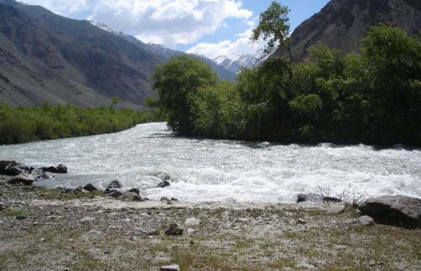
In the Jamoat Vankala area of the Shugnan district in GBAO, low temperatures make it very difficult to grow fruit or trees other than poplar (Populus pamirico) or Salix Schugnanica Coerz.
The natural forest consists mainly of the latter and this grows very slowly. It is very cold for 6-7 months of the year in this region, so the demand for cheap firewood to heat homes is extremely high.
In the 1980s, the sovhoz decided to transform 10ha of a low productivity pasture land into more productive irrigated forest land. After the collapse of the Soviet system, the Jamoat rented this forest land to a farmer, who still remains in charge of this piece of land.
Purpose of the Technology: The creation of a poplar forest on the river shore in this treeless desert alpine zone can go someway towards meeting the local's demand for firewood. It can provide cheap timber and environmental benefits as well as a pleasant environment.
Establishment / maintenance activities and inputs: The process of establishing this poplar forest began with the creation of irrigation canals and the planting of seedlings. In the first few years, the seedlings had to be watered frequently due to the thirsty sandy soils.
Other factors that needed to be considered were protecting the area from grazing cattle, watering areas around the forest away from the the river bank, the selective felling of some poplars, the additional planting of trees on barren soil, as well as the protection of the forest from predatory deforestation by the locals (which has increased during the economic crisis). Thanks to natural regeneration processes, farmers can now prepare firewood for the winter and do not have to bring the timber from far away.
Natural / human environment: 88% of the Pamir region is covered by glaciers, snow, and rocks, and is thus completely devoid of soil. Consequently, the area of arable and orchard lands in the GBAO region is only about 2%, with a forest area of 0.4%. Two-thirds of all the Pamir natural forests are located along the river banks of the Vanch, Gunt, Tokuzbulak, and others, at an altitude of 3200m.
In the narrow V-shaped valleys of the Western Pamirs, the lowest points are at an altitude of 1,200m,extending up to the highest points at 7,400m. This explains the climatic differences within the region, because the lower parts in the valleys enjoy a warmer climate than the higher parts. Overall, the annual average air temperature in the region is 9°C, and most rainfall occurs between the winter and spring periods with an average precipitation of 191-227mm.
2.3 ຮູບພາບຂອງເຕັກໂນໂລຢີ
ສື່ຮູບພາບ
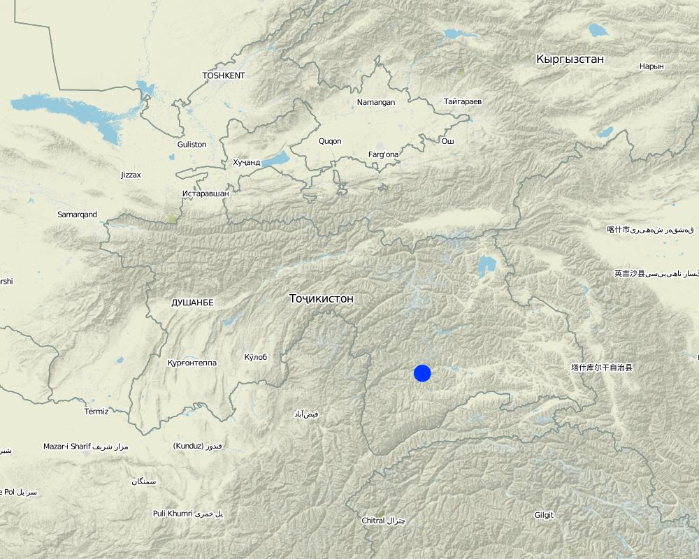
2.5 ປະເທດ / ເຂດ / ສະຖານທີ່ບ່ອນທີ່ ເຕັກໂນໂລຢີ ໄດ້ຮັບການນໍາໃຊ້ ແລະ ທີ່ຖືກປົກຄຸມດ້ວຍການປະເມີນຜົນ
ປະເທດ:
ຕາຈິກິສະຕານ
ພາກພື້ນ / ລັດ / ແຂວງ:
Tajikistan / GBAO
ຂໍ້ມູນເພີ່ມເຕີມຂອງສະຖານທີ່:
Shugnan / Vankala
Map
×2.6 ວັນທີໃນການຈັດຕັ້ງປະຕິບັດ
ຖ້າຫາກວ່າ ບໍ່ຮູ້ຈັກ ປີທີ່ຊັດເຈນ ແມ່ນໃຫ້ປະມານ ວັນທີເອົາ:
- 10-50 ປີ ຜ່ານມາ
2.7 ການນໍາສະເໜີ ເຕັກໂນໂລຢີ
ໃຫ້ລະບຸ ເຕັກໂນໂລຢີ ໄດ້ຖືກຈັດຕັ້ງປະຕິບັດຄືແນວໃດ?
- ໂດຍຜ່ານນະວັດຕະກໍາຄິດຄົ້ນຂອງຜູ້ນໍາໃຊ້ທີ່ດິນ
ຄວາມຄິດເຫັນ (ປະເພດ ໂຄງການ ແລະ ອື່ນໆ):
During the 1980s much of the low productivity sandy land was converted to poplar forest. This was initiated by a local group who put in many voluntary hours. From 1993 onwards, this forest was part of the local jamoat "Vankala" lands. The local administration rented it to a local farmer- (Jonbekov Ikbol).
3. ການໃຈ້ແຍກ ເຕັກໂນໂລຢີ ໃນການຄຸ້ມຄອງ ດິນແບບຍືນຍົງ
3.1 ຈຸດປະສົງຫຼັກ (ຫຼາຍ) ຂອງເຕັກໂນໂລຢີ
- ຫຼຸດຜ່ອນຜົນກະທົບ ຈາກການປ່ຽນແປງດິນຟ້າອາກາດ
- ສ້າງຜົນກະທົບ ທາງເສດຖະກິດ ທີ່ເປັນປະໂຫຍດ
3.2 ປະເພດການນໍາໃຊ້ທີ່ດິນ ໃນປະຈຸບັນ() ທີ່ເຕັກໂນໂລຢີ ໄດ້ຖືກນໍາໃຊ້

ປ່າໄມ້ / ປ່າ
(ເຄິ່ງ) ປ່າໄມ້ທໍາມະຊາດ / ປ່າປູກໄມ້:
- ການຄັດເລືອກຕັດ
ການປູກຕົ້ນໄມ້, ການປູກປ່າ:
- ການປູກໄມ້ ແນວພັນພື້ນເມືອງ ຊະນິດດຽວ
ຜົນຜະລິດ ແລະ ການບໍລິການ:
- ເຄື່ອງປ່າຂອງດົງ
- ໄມ້ຟືນ
- ທົ່ງຫຍ້າ
- ການອະນຸລັກທໍາມະຊາດ / ການປ້ອງກັນ
- ນັນທະນາການ / ການທ່ອງທ່ຽວ
- ປ້ອງກັນ ການຄຸກຄາມ ທາງທໍາມະຊາດ
ຄວາມຄິດເຫັນ:
Major land use problems (compiler’s opinion): The main problems include; Low soil productivity, a short growing season, desertification, low temperatures and a sharp drop in average daily temperatures and an early night frost. Very sparse vegetation of drought-tolerant grass and little shrubs
Major land use problems (land users’ perception): water shortages, low soil fertility, low yields
Selective felling of (semi-) natural forests: Every autumn
Plantation forestry: Every year they plant new seedlings to assist with afforestation
Forest products and services: timber, fuelwood, grazing / browsing, nature conservation / protection, recreation / tourism, protection against natural hazards
Future (final) land use (after implementation of SLM Technology): Forests / woodlands: Fp: Plantations, afforestations
Type of cropping system and major crops comments: The farmer owns 1-2 of his own cows which graze in the forest over the smmer. They use these cows for milk. The cows are not allowed to roam free, they are tied up. Someimes the children try to sell milk and dairy products on the roadside, but there is not much passing trade.
Livestock is grazing on crop residues
ຖ້າຫາກວ່າ ການນໍາໃຊ້ທີ່ດິນ ມີການປ່ຽນແປງ ໃນເວລາ ຈັດຕັ້ງປະຕິບັດ ເຕັກໂນໂລຢີ, ແມ່ນໃຫ້ລະບຸວ່າ ດິນພື້ນທີ່ດັ່ງກ່າວ ເຄີຍເປັນດິນປະເພດໃດ ກ່ອນການຈັດຕັ້ງປະຕິບັດ ເຕັກໂນໂລຢີ:
Grazing land: Ge: Extensive grazing land
3.3 ຂໍ້ມູນເພີ່ມເຕີມກ່ຽວກັບການນໍາໃຊ້ທີ່ດິນ
ການສະໜອງນໍ້າ ໃນພື້ນທີ່ ທີ່ໄດ້ນໍາໃຊ້ ເຕັກໂນໂລຢີ:
- ນໍາໃຊ້ ນໍ້າຊົນລະປະທານ ພຽງຢ່າງດຽວ
ຄວາມຄິດເຫັນ:
Water supply: Also mixed rainfed
ລະບຸ ຊະນິດ:
Longest growing period in days: 120 longest growing period from month to month: May- September
3.4 ການນໍາໃຊ້ເຕັກໂນໂລຢີ ທີ່ຢູ່ໃນກຸ່ມການຄຸ້ມຄອງ ທີ່ດິນແບບຍືນຍົງ
- ການປັບປຸງດິນ / ພືດຄຸມດິນ
- ຫຼຸດຜ່ອນຄວາມສ່ຽງ ທາງໄພພິບັດ ບົນພື້ນຖານລະບົບນິເວດ
3.6 ມາດຕະການ ການຄຸ້ມຄອງ ທີ່ດິນແບບຍືນຍົງ ປະກອບດ້ວຍ ເຕັກໂນໂລຢີ

ມາດຕະການ ທາງການກະສິກໍາ
- A1: ພືດ / ການປົກຫຸ້ມຂອງດິນ

ມາດຕະການ ທາງດ້ານພືດພັນ
- V1: ເປັນໄມ້ຢືນຕົ້ນ ແລະ ການປົກຫຸ້ມຂອງໄມ້ພຸ່ມ

ມາດຕະການໂຄງສ້າງ
- S3: ຮ່ອງ, ຄອງນໍ້າ, ທາງໄຫຼນໍ້າ

ມາດຕະການ ທາງດ້ານການຄຸ້ມຄອງ
- M1: ການປ່ຽນແປງ ປະເພດ ການນໍາໃຊ້ທີ່ດິນ
ຄວາມຄິດເຫັນ:
Main measures: vegetative measures, management measures
Secondary measures: structural measures
Type of vegetative measures: in blocks
3.7 ປະເພດດິນເຊື່ອມໂຊມ ຫຼັກທີ່ໄດ້ນໍາໃຊ້ ເຕັກໂນໂລຢີ

ດິນເຊາະເຈື່ອນ ໂດຍນໍ້າ
- Wt: ການສູນເສຍຊັ້ນໜ້າດິນ / ການເຊາະເຈື່ອນຜິວໜ້າດິນ

ການເຊື່ອມໂຊມ ຂອງດິນ ທາງເຄມີ
- Cn: ຄວາມອຸດົມສົມບູນ ລົດໜ້ອຍຖອຍລົງ ແລະ ສານອິນຊີວັດຖຸລົດລົງ (ບໍ່ແມ່ນສາເຫດມາຈາກການເຊາະເຈື່ອນ)

ການເຊື່ອມໂຊມ ທາງຊີວະພາບ
- Bc: ການຫຼຸດຜ່ອນການປົກຫຸ້ມຂອງພືດ
- Bq: ປະລິມານ / ອິນຊີວັດຖຸຫຼຸດລົງ
ຄວາມຄິດເຫັນ:
Main type of degradation addressed: Cn: fertility decline and reduced organic matter content, Bc: reduction of vegetation cover, Bq: quantity / biomass decline
Secondary types of degradation addressed: Wt: loss of topsoil / surface erosion
Main causes of degradation: deforestation / removal of natural vegetation (incl. forest fires) (24hr electricity has been available only for the last 2 years. Over the last 16 years the local population have cut down all the surrounding trees.), over-exploitation of vegetation for domestic use (All the trees were cut down for use as animal feed and fire wood.), overgrazing (Livestock were grazed in the areas around the village all year round.), change in temperature (The summeres have become colder in recent years, the summer became more colder, most of crops ripen at low temperatures), poverty / wealth (most of the population are poor, thus placing high pressure on the natural reasources as they are forced to use these for fuel and food.)
Secondary causes of degradation: droughts (Low levels of rain fall, strong сold winds, high insolaton, low soil moisture), war and conflicts (During the civil war the area had high rates of food insecurity.)
3.8 ການປ້ອງກັນ, ການຫຼຸດຜ່ອນ, ຫຼືການຟື້ນຟູຂອງການເຊື່ອມໂຊມຂອງດິນ
ໃຫ້ລະບຸ ເປົ້າໝາຍ ເຕັກໂນໂລຢີ ທີ່ພົວພັນ ກັບຄວາມເຊື່ອມໂຊມຂອງດິນ:
- ຫຼຸດຜ່ອນການເຊື່ອມໂຊມຂອງດິນ
- ການຟື້ນຟູ / ຟື້ນຟູດິນທີ່ຊຸດໂຊມ
ຄວາມຄິດເຫັນ:
Secondary goals: prevention of land degradation
4. ຂໍ້ກໍາໜົດ, ກິດຈະກໍາການປະຕິບັດ, ວັດຖຸດິບ, ແລະຄ່າໃຊ້ຈ່າຍ
4.2 ການແຕ້ມແຜນວາດອະທິບາຍເຕັກນິກ
Technical knowledge required for field staff / advisors: low
Technical knowledge required for land users: moderate (Needs to use chainsaws so some extra technical knowledge required.)
Main technical functions: improvement of ground cover, increase in organic matter, increase of biomass (quantity), spatial arrangement and diversification of land use
Secondary technical functions: improvement of topsoil structure (compaction), improvement of subsoil structure (hardpan), stabilisation of soil (eg by tree roots against land slides), increase in nutrient availability (supply, recycling,…), increase / maintain water stored in soil, reduction in wind speed, promotion of vegetation species and varieties (quality, eg palatable fodder)
Aligned: -contour
Vegetative material: T : trees / shrubs
Aligned: -graded strips
Vegetative material: T : trees / shrubs
In blocks
Vegetative material: T : trees / shrubs
Number of plants per (ha): 400
Vertical interval within rows / strips / blocks (m): 5
Width within rows / strips / blocks (m): 5
Vegetative measure: Vegetative material: T : trees / shrubs
Vegetative measure: Vegetative material: T : trees / shrubs
Vegetative measure: Vegetative material: T : trees / shrubs
Vegetative measure: Vegetative material: T : trees / shrubs
Trees/ shrubs species: Populus pamirico, Salix Schugnanica Coerz, dog rose
Grass species: different natural grasses
Slope (which determines the spacing indicated above): 5.00%
Structural measure: main irrigation canal along the plot upper border
Depth of ditches/pits/dams (m): 0.5
Width of ditches/pits/dams (m): 0.8
Length of ditches/pits/dams (m): 2000
Structural measure: irrigation networks inside the forest
Vertical interval between structures (m): 5
Spacing between structures (m): 5
Depth of ditches/pits/dams (m): 0.2
Width of ditches/pits/dams (m): 0.3
Length of ditches/pits/dams (m): 200000
Slope (which determines the spacing indicated above): 5%
If the original slope has changed as a result of the Technology, the slope today is: 5%
Change of land use type: low-productivity grasslands have changed to a high productive poplar forest
Change of land use practices / intensity level: Changed from an area of open access to locals, to having controlled access (pasture land, forest land)
4.3 ຂໍ້ມູນທົ່ວໄປກ່ຽວກັບການຄິດໄລ່ປັດໃຈຂາເຂົ້າໃນການຜະລິດ ແລະ ມູນຄ່າອື່ນໆ
ສະກຸນເງິນອື່ນໆ / ປະເທດອື່ນໆ (ລະບຸ):
Somoni
ລະບຸ ອັດຕາແລກປ່ຽນ ຈາກໂດລາ ເປັນເງິນຕາທ້ອງຖີ່ນ (ຖ້າກ່ຽວຂ້ອງ): 1 ໂດລາ =:
4.53
ລະບຸ ຄ່າຈ້າງ ຄ່າແຮງງານສະເລ່ຍ ຕໍ່ ວັນ:
30
4.4 ການສ້າງຕັ້ງກິດຈະກໍາ
| ກິດຈະກໍາ | ປະເພດ ມາດຕະການ | ໄລຍະເວລາ | |
|---|---|---|---|
| 1. | Growing seedlings in a nursery | ການບໍາລຸງລ້ຽງ | one year (5 month irrigation) |
| 2. | Digging holes 50x60cm on 1 ha - 400 on 10 hectares - 4000 holes | ການບໍາລຸງລ້ຽງ | During Spring |
| 3. | Manure (dung) | ການບໍາລຸງລ້ຽງ | in Spring |
| 4. | Delivering of manure to plot by tractor and truck | ການບໍາລຸງລ້ຽງ | in Spring |
| 5. | Prepare a mixture of soil and dung for filling planting holes on 10 ha | ການບໍາລຸງລ້ຽງ | in Spring |
| 6. | Planting poplar seedlings and watering them | ການບໍາລຸງລ້ຽງ | in Spring |
| 7. | Planting trees along the irrigation canal along the road to Jelondi and the upper boundaries of the site (10m on 1day) | ໂຄງສ້າງ | before tree planting in spring |
| 8. | Establishment of irrigation networks from the canal in the garden(7x 1000м per day) | ໂຄງສ້າງ | before tree planting in spring |
| 9. | Collection of sea buck thorn stems and branches | ການຈັດການຄຸ້ມຄອງ | before tree planting |
| 10. | Load sea buck thorn stems and branches into the car and unloadthem | ການຈັດການຄຸ້ມຄອງ | before tree planting |
| 11. | Delivering stems and branches using a car | ການຈັດການຄຸ້ມຄອງ | before tree planting |
| 12. | Fencing the area | ການຈັດການຄຸ້ມຄອງ | before trees planting |
4.5 ຕົ້ນທຶນ ແລະ ປັດໄຈຂາເຂົ້າທີ່ຈໍາເປັນໃນຈັດຕັ້ງປະຕິບັດ
| ລະບຸ ປັດໃຈ ນໍາເຂົ້າ ໃນການຜະລີດ | ຫົວໜ່ວຍ | ປະລິມານ | ຕົ້ນທຶນ ຕໍ່ຫົວໜ່ວຍ | ຕົ້ນທຶນທັງໝົດ ຂອງປັດໃຈຂາເຂົ້າ ໃນການຜະລິດ | % ຂອງຕົ້ນທຶນທັງໝົດ ທີ່ຜູ້ນໍາໃຊ້ທີ່ດິນ ໃຊ້ຈ່າຍເອງ | |
|---|---|---|---|---|---|---|
| ແຮງງານ | Growing seedlings in a nursery (irrigation and nursering) | Persons/day | 25.0 | 30.0 | 750.0 | 100.0 |
| ແຮງງານ | Digging holes | Persons/day | 100.0 | 30.0 | 3000.0 | 100.0 |
| ແຮງງານ | Prepare a mixture of soil and dung | Persons/day | 40.0 | 30.0 | 1200.0 | 100.0 |
| ແຮງງານ | Planting poplar seedlings and watering them | Persons/day | 40.0 | 30.0 | 1200.0 | 100.0 |
| ອຸປະກອນ | Tractor for delivering manure | hours | 8.0 | 75.0 | 600.0 | 100.0 |
| ອຸປະກອນ | Labour: Planting trees along the irrigation canal | Persons/day | 200.0 | 30.0 | 6000.0 | 100.0 |
| ອຸປະກອນ | Labour: Establishment of irrigation networks from the canal in the garden | Persons/day | 30.0 | 30.0 | 900.0 | 100.0 |
| ອຸປະກອນ | Car for transporting branches | Trucks/day | 20.0 | 100.0 | 2000.0 | 100.0 |
| ຝຸ່ນ ແລະ ຢາຊີວະພາບ | Manure (dung) | tons | 40.0 | 50.0 | 2000.0 | 100.0 |
| ອື່ນໆ | Labour: Collection of sea buck thorn stems and branches | Persons/day | 20.0 | 30.0 | 600.0 | 100.0 |
| ອື່ນໆ | Labour: Load sea buck thorn stems and branches into the car and unload them | Persons/day | 10.0 | 30.0 | 300.0 | 100.0 |
| ອື່ນໆ | Labour: Fencing the area | Persons/day | 100.0 | 30.0 | 3000.0 | 100.0 |
| ຕົ້ນທຶນທັງໝົດ ໃນການຈັດຕັ້ງປະຕິບັດ ເຕັກໂນໂລຢີ | 21550.0 | |||||
4.6 ບໍາລຸງຮັກສາ / ແຜນຈັດຕັ້ງປະຕິບັດ ກິດຈະກໍາ
| ກິດຈະກໍາ | ປະເພດ ມາດຕະການ | ໄລຍະເວລາ / ຄວາມຖີ່ | |
|---|---|---|---|
| 1. | Watering seedlings 2 times per week first year (40 pers days on 1 month - 10 ha) | ການບໍາລຸງລ້ຽງ | 5 months per year |
| 2. | Watering seedlings once per week per year (20 pers days -1 month- 10 ha) | ການບໍາລຸງລ້ຽງ | 5 months per year |
| 3. | Protection, avoidance of grazing(5 hour per day) | ການບໍາລຸງລ້ຽງ | 5 months per year |
| 4. | Annual harvest of firewood | ການບໍາລຸງລ້ຽງ | every year/autumn |
| 5. | Selective felling of trees(Ø=40-50см) | ການບໍາລຸງລ້ຽງ | After 10 years / October |
| 6. | Annual haymaking of natural grass | ການບໍາລຸງລ້ຽງ | every year/summer |
| 7. | Repairs and cleaning of the main irrigation canal to clear sediment and debris | ໂຄງສ້າງ | Before the irrigation season/in spring |
| 8. | Repairs and cleaning of the irrigation network to clear sediment and brancheson 10 ha | ໂຄງສ້າງ | Before the irrigation season in spring |
| 9. | Repairing fences | ການຈັດການຄຸ້ມຄອງ | if needed |
4.7 ຄ່າໃຊ້ຈ່າຍ ແລະ ປັດໄຈນໍາເຂົ້າທີ່ຈໍາເປັນສໍາລັບການບໍາລຸງຮັກສາກິດຈະກໍາ / ແຜນປະຕິບັດ (ຕໍ່ປີ)
| ລະບຸ ປັດໃຈ ນໍາເຂົ້າ ໃນການຜະລີດ | ຫົວໜ່ວຍ | ປະລິມານ | ຕົ້ນທຶນ ຕໍ່ຫົວໜ່ວຍ | ຕົ້ນທຶນທັງໝົດ ຂອງປັດໃຈຂາເຂົ້າ ໃນການຜະລິດ | % ຂອງຕົ້ນທຶນທັງໝົດ ທີ່ຜູ້ນໍາໃຊ້ທີ່ດິນ ໃຊ້ຈ່າຍເອງ | |
|---|---|---|---|---|---|---|
| ແຮງງານ | Watering seedlings (First year and followin year) | Persons/day | 300.0 | 30.0 | 9000.0 | 100.0 |
| ແຮງງານ | Protection, avoidance of grazing | Persons/day | 87.0 | 30.0 | 2610.0 | 100.0 |
| ແຮງງານ | Annual harvest of firewood | Persons/day | 10.0 | 30.0 | 300.0 | 100.0 |
| ແຮງງານ | Selective felling of trees (after 10 years | Persons/day | 15.0 | 30.0 | 450.0 | |
| ອື່ນໆ | Labour: Annual haymaking of natural grass | Persons/day | 40.0 | 30.0 | 1200.0 | |
| ອື່ນໆ | Labour: Repairs and cleaning of the main irrigation canal abd irrigation network | Persons/day | 15.0 | 30.0 | 450.0 | |
| ຕົ້ນທຶນທັງໝົດ ທີ່ໃຊ້ໃນການບໍາລຸງຮັກສາ ເຕັກໂນໂລຢີ | 14010.0 | |||||
ຄວາມຄິດເຫັນ:
Machinery/ tools: shovel
The costs were calculated for the whole plantation area of 10 ha
4.8 ປັດໄຈ ທີ່ສໍາຄັນ ທີ່ສົ່ງຜົນກະທົບ ຕໍ່ຄ່າໃຊ້ຈ່າຍ
ໃຫ້ອະທິບາຍ ປັດໃຈ ທີ່ສົ່ງຜົນກະທົບ ຕໍ່ຕົ້ນທຶນ ໃນການຈັດຕັ້ງປະຕິບັດ:
Labour is the most determinate factor affecting the costs, however, in this situation, most of it was provided by the land users themselves. Costs reported are those for additional labour that would need to be paid for.
5. ສະພາບແວດລ້ອມທໍາມະຊາດ ແລະ ມະນຸດ
5.1 ອາກາດ
ປະລິມານນໍ້າຝົນປະຈໍາປີ
- < 250 ມີລິແມັດ
- 251-500 ມີລິແມັດ
- 501-750 ມີລິແມັດ
- 751-1,000 ມີລິແມັດ
- 1,001-1,500 ມີລິແມັດ
- 1,501-2,000 ມີລິແມັດ
- 2,001-3,000 ມີລິແມັດ
- 3,001-4,000 ມີລິແມັດ
- > 4,000 ມີລິແມັດ
ຂໍ້ມູນສະເພາະ / ຄວາມເຫັນກ່ຽວກັບ ປະລິມານນໍ້າຝົນ:
200-230 mm average rainfall. Main season is during winter to spring period.
ເຂດສະພາບອາກາດກະສິກໍາ
- ແຫ້ງແລ້ງ
Thermal climate class: boreal
In general, the Pamirs are is characterised by dry air and low precipitation
5.2 ພູມິປະເທດ
ຄ່າສະເລ່ຍ ຄວາມຄ້ອຍຊັນ:
- ພື້ນທີ່ຮາບພຽງ (0-2%)
- ອ່ອນ (3-5 %)
- ປານກາງ (6-10 %)
- ມ້ວນ (11-15 %)
- ເນີນ(16-30%)
- ໍຊັນ (31-60%)
- ຊັນຫຼາຍ (>60%)
ຮູບແບບຂອງດິນ:
- ພູພຽງ / ທົ່ງພຽງ
- ສັນພູ
- ເປີ້ນພູ
- ເນີນພູ
- ຕີນພູ
- ຮ່ອມພູ
ເຂດລະດັບສູງ:
- 0-100 ແມັດ a.s.l.
- 101-500 ແມັດ a.s.l.
- 501-1,000 ແມັດ a.s.l.
- 1,001-1,500 ແມັດ a.s.l.
- 1,501-2,000 ແມັດ a.s.l.
- 2,001-2,500 ແມັດ a.s.l.
- 2,501-3,000 ແມັດ a.s.l.
- 3,001-4,000 ແມັດ a.s.l.
- > 4,000 ແມັດ a.s.l.
ໃຫ້ລະບຸ ເຕັກໂນໂລຢີ ທີ່ໄດ້ຖືກນຳໃຊ້:
- ລັກສະນະກີ່ວ
ຄຳເຫັນ ແລະ ຂໍ້ມູນສະເພາະ ເພີ່ມເຕີມ ກ່ຽວກັບ ພູມີປະເທດ:
Altitudinal zone: 3200 m a.s.l.
Slopes on average: It is a narrow river valley
5.3 ດິນ
ຄວາມເລິກ ຂອງດິນສະເລ່ຍ:
- ຕື້ນຫຼາຍ (0-20 ຊັງຕີແມັດ)
- ຕື້ນ (21-50 ຊຕມ)
- ເລີກປານກາງ (51-80 ຊຕມ)
- ເລິກ (81-120 ຊມ)
- ເລິກຫຼາຍ (> 120 cm)
ເນື້ອດິນ (ໜ້າດິນ):
- ຫຍາບ / ເບົາ (ດິນຊາຍ)
ຊັ້ນອິນຊີວັດຖຸ ເທິງໜ້າດິນ:
- ປານກາງ (1-3 %)
ຖ້າເປັນໄປໄດ້ ແມ່ນໃຫ້ຕິດຄັດ ການພັນລະນາດິນ ຫຼື ຂໍ້ມູນສະເພາະຂອງດິນ, ຕົວຢ່າງ, ຄຸນລັກສະນະ ປະເພດຂອງດິນ, ຄ່າຄວາມເປັນກົດ / ເປັນດ່າງຂອງດິນ, ສານອາຫານ, ດິນເຄັມ ແລະ ອື່ນໆ.
Soil depth on average: The soil is sandy-loam, shallow, with low productivity
Soil texture: Sandy-loamy soil
These soils have low natural fertility, and irrigation increases the productivity of this soil
Topsoil organic matter: After irrigation and changing the land use type, organic matter increases
Soil drainage / infiltration is good because this soil is sandy-loam
Soil water storage capacity is low because this soil is sandy-loam
5.4 ມີນໍ້າ ແລະ ຄຸນນະພາບ
ລະດັບ ນໍ້າໃຕ້ດິນ:
< 5 ແມັດ
ການມີນໍ້າ ເທິງໜ້າດິນ:
ດີ
ຄຸນນະພາບນໍ້າ (ບໍ່ມີການບໍາບັດ):
ມີນໍ້າດື່ມ
ຄວາມຄິດເຫັນ ແລະ ຂໍ້ກໍານົດ ເພີ່ມເຕີມ ກ່ຽວກັບ ຄຸນນະພາບ ແລະ ປະລິມານ ຂອງນ້ຳ:
Ground water table: 2/3 of the forest is close to the river and the ground water level is 2-3m
Availability of surface water: The River Tokuzbulak is in close proximity (somtimes also just medium)
Water quality (untreated): The river can provide clean drinking water
5.5 ຊີວະນາໆພັນ
ຄວາມຫຼາກຫຼາຍ ທາງສາຍພັນ:
- ສູງ
ຄວາມຄິດເຫັນ ແລະ ລັກສະນະສະເພາະ ເພີ່ມເຕີມກ່ຽວກັບ ຊີວະນາໆພັນ:
Poplar trees provide a favourable microclimate for growing many bushes and herbaceous plants beneath, and also provides a good natural habitat for birds and some wild animals.
5.6 ຄຸນລັກສະນະ ຂອງຜູ້ນໍາໃຊ້ທີ່ດິນ ທີ່ໄດ້ນໍາໃຊ້ເຕັກໂນໂລຢີ
ລະບົບ ການຕະຫຼາດ ແລະ ຜົນຜະລິດ:
- ກຸ້ມຕົນເອງ (ພໍພຽງ)
- ປະສົມ (ກຸ້ມຕົນເອງ / ເປັນສິນຄ້າ
ລາຍຮັບ ທີ່ບໍ່ໄດ້ມາຈາກ ການຜະລິດ ກະສິກໍາ:
- > 50 % ຂອງລາຍຮັບທັງໝົດ
ລະດັບຄວາມຮັ່ງມີ:
- ຮັ່ງມີ
ບຸກຄົນ ຫຼື ກຸ່ມ:
- ບຸກຄົນ / ຄົວເຮືອນ
ລະດັບ ການຫັນເປັນກົນຈັກ:
- ການໃຊ້ແຮງງານຄົນ
ເພດ:
- ຜູ້ຍິງ
- ຜູ້ຊາຍ
ໃຫ້ລະບຸ ຄຸນລັກສະນະ ຂອງຜູ້ນໍາໃຊ້ທີ່ດິນ:
Land users applying the Technology are mainly Leaders / privileged
Population density: < 10 persons/km2
Annual population growth: 2% - 3%
10% of the land users are rich (He has a car, big forest plot, 5 yaks, 2 cows, 20 sheep).
Off-farm income specification: The farmer owns a car, sometimes he works as a tour gide, he sells the timber and firewood, and in autumn he buys meat in Murgab to resell in Khatlon.
Market orientation of production system: subsistence (self-supply), mixed (subsistence/ commercial, mixed (subsistence/ commercial
Market orientation of production system: In the first 7 years subsistence and after 7-10 years some of the trees had reached maturity, the rest he sold (20-30m3). ( In the autumn haymaking and firewood (10m3) for himself and 3 cars (30m3) firewood for sale)
Level of mechanization: Watering, pruning of poplars, haymaking is all manual
5.7 ພື້ນທີ່ສະເລ່ຍຂອງທີ່ດິນ ຫຼື ເຊົ່າໂດຍຜູ້ໃຊ້ທີ່ດິນການນໍາໃຊ້ ເຕັກໂນໂລຢີ
- <0.5 ເຮັກຕາ
- 0.5-1 ເຮັກຕາ
- 1-2 ເຮັກຕາ
- 2-5 ເຮັກຕາ
- 5-15 ເຮັກຕາ
- 15-50 ເຮັກຕາ
- 50-100 ເຮັກຕາ
- 100-500 ເຮັກຕາ
- 500-1,000 ເຮັກຕາ
- 1,000-10,000 ເຮັກຕາ
- > 10,000 ເຮັກຕາ
ຖືໄດ້ວ່າ ເປັນຂະໜາດນ້ອຍ, ກາງ ຫຼື ໃຫຍ່ (ອີງຕາມເງື່ອນໄຂ ສະພາບຄວາມເປັນຈິງ ຂອງທ້ອງຖີ່ນ)? :
- ຂະໜາດກາງ
ຄວາມຄິດເຫັນ:
At 1-2 ha: The area of crop land in the Western Pamirs is very small.
At 2-5 ha: This farmer has 3 ha of crop land because there is a small population in this village.
At 0.5-1 ha the population is more dense.
Also 5-15 ha, but it is rare that one individual farmer is rented such a large area of forest.
5.8 ເຈົ້າຂອງທີ່ດິນ, ສິດໃຊ້ທີ່ດິນ, ແລະ ສິດທິການນໍາໃຊ້ນໍ້າ
ເຈົ້າຂອງດິນ:
- ລັດ
ສິດທິ ໃນການນໍາໃຊ້ທີ່ດິນ:
- ເຊົ່າ
ສິດທິ ໃນການນໍາໃຊ້ນໍ້າ:
- ເປີດກວ້າງ (ບໍ່ມີການຈັດຕັ້ງ)
ຄວາມຄິດເຫັນ:
before 1992-93 it was the Sovhoz forest land, after 1993 the forest was in the Vankala Jamoat. The farmer rents this land.
5.9 ການເຂົ້າເຖິງການບໍລິການ ແລະ ພື້ນຖານໂຄງລ່າງ
ສຸຂະພາບ:
- ທຸກຍາກ
- ປານກາງ
- ດີ
ການສຶກສາ:
- ທຸກຍາກ
- ປານກາງ
- ດີ
ການຊ່ວຍເຫຼືອ ດ້ານວິຊາການ:
- ທຸກຍາກ
- ປານກາງ
- ດີ
ການຈ້າງງານ (ຕົວຢ່າງ, ການເຮັດກິດຈະກໍາອື່ນ ທີ່ບໍ່ແມ່ນ ການຜະລິດກະສິກໍາ):
- ທຸກຍາກ
- ປານກາງ
- ດີ
ຕະຫຼາດ:
- ທຸກຍາກ
- ປານກາງ
- ດີ
ພະລັງງານ:
- ທຸກຍາກ
- ປານກາງ
- ດີ
ຖະໜົນຫົນທາງ ແລະ ການຂົນສົ່ງ:
- ທຸກຍາກ
- ປານກາງ
- ດີ
ການດື່ມນໍ້າ ແລະ ສຸຂາພິບານ:
- ທຸກຍາກ
- ປານກາງ
- ດີ
ການບໍລິການ ທາງດ້ານການເງິນ:
- ທຸກຍາກ
- ປານກາງ
- ດີ
6. ຜົນກະທົບ ແລະ ລາຍງານສະຫຼຸບ
6.1 ການສະແດງຜົນກະທົບ ພາຍໃນພື້ນທີ່ ທີ່ໄດ້ຈັດຕັ້ງປະຕິບັດ ເຕັກໂນໂລຢີ
ຜົນກະທົບທາງເສດຖະກິດສັງຄົມ
ການຜະລິດ
ການຜະລິດອາຫານສັດ
ຄວາມຄິດເຫັນ / ລະບຸແຈ້ງ:
natural grass under the trees
ຄຸນນະພາບຂອງອາຫານສັດ
ຄວາມຄິດເຫັນ / ລະບຸແຈ້ງ:
More grasses and edible plants grow under the shadow of the trees.
ຜົນຜະລິດຂອງສັດ
ຄວາມຄິດເຫັນ / ລະບຸແຈ້ງ:
more furaj more animals
ຜົນຜະລິດໄມ້
ປະລິມານ ກ່ອນການຈັດຕັ້ງປະຕິບັດ ການຄຸ້ມຄອງ ທີ່ດິນແບບຍືນຍົງ:
10%
ປະລີມານ ຫຼັງການຈັດຕັ້ງປະຕິບັດ ການຄຸ້ມຄອງ ທີ່ດິນແບບຍືນຍົງ:
100%
ການຜະລິດພະລັງງານ
ປະລີມານ ຫຼັງການຈັດຕັ້ງປະຕິບັດ ການຄຸ້ມຄອງ ທີ່ດິນແບບຍືນຍົງ:
100%
ລາຍໄດ້ ແລະ ຄ່າໃຊ້ຈ່າຍ
ລາຍຮັບ ຈາກການຜະລີດ
ຄວາມຄິດເຫັນ / ລະບຸແຈ້ງ:
More animals and firewood that he can sell.
ຄວາມຫຼາກຫຼາຍ ຂອງແຫຼ່ງລາຍຮັບ
ຄວາມຄິດເຫັນ / ລະບຸແຈ້ງ:
He can sell firewood, meat, dairy products, and can be a touris guide.
ຜົນກະທົບດ້ານວັດທະນາທໍາສັງຄົມ
ການຄໍ້າປະກັນ ສະບຽງອາຫານ / ກຸ້ມຢູ່ກຸ້ມກິນ
ໂອກາດ ໃນການພັກຜ່ອນຢ່ອນໃຈ
ປະລິມານ ກ່ອນການຈັດຕັ້ງປະຕິບັດ ການຄຸ້ມຄອງ ທີ່ດິນແບບຍືນຍົງ:
5%
ປະລີມານ ຫຼັງການຈັດຕັ້ງປະຕິບັດ ການຄຸ້ມຄອງ ທີ່ດິນແບບຍືນຍົງ:
100%
ຄວາມຄິດເຫັນ / ລະບຸແຈ້ງ:
The environmnt looks much more pleasant with more green areas.
ຄວາມຮູ້ກ່ຽວກັບ ການຄຸ້ມຄອງ ທີ່ດິນແບບຍືນຍົງ / ການເຊື່ອມໂຊມຂອງດິນ
ການຫຼຸດຜ່ອນ ຂໍ້ຂັດແຍ່ງ
ຄວາມຄິດເຫັນ / ລະບຸແຈ້ງ:
The area is too big for one farmer
Livelihood and human well-being
ຄວາມຄິດເຫັນ / ລະບຸແຈ້ງ:
The extra money earned from the sale of timber, firewood and livestock can be spent on health and education for the family
ຜົນກະທົບຕໍ່ລະບົບນິເວດ
ດິນ
ຄວາມຊຸ່ມຂອງດິນ
ຄວາມຄິດເຫັນ / ລະບຸແຈ້ງ:
Reduces evaporation from the soil surface
ການປົກຄຸມຂອງດິນ
ຄວາມຄິດເຫັນ / ລະບຸແຈ້ງ:
good vegetation cover helps improve the soil cover
ການສູນເສຍດິນ
ຄວາມຄິດເຫັນ / ລະບຸແຈ້ງ:
The trees and grass roots stabilise the soil
ວົງຈອນ ຂອງສານອາຫານໃນດິນ
ຄວາມຄິດເຫັນ / ລະບຸແຈ້ງ:
Matter and roots of the herbaceous plants, improves structure and fertility of the soil
ອິນຊີວັດຖຸໃນດິນ / ຢູ່ລຸ່ມຊັ້ນດິນ C
ຄວາມຄິດເຫັນ / ລະບຸແຈ້ງ:
SOM is increased underneath the poplar forest
ຊີວະນານາພັນ: ສັດ, ພືດ
ມວນຊີວະພາບ / ຢູ່ເທິງຊັ້ນດິນ C
ຄວາມຫຼາກຫຼາຍຂອງພືດ
ຄວາມຄິດເຫັນ / ລະບຸແຈ້ງ:
The diversity of plants is higher than in the surrounding areas
ຄວາມຫຼາກຫຼາຍຂອງສັດ
ຄວາມຄິດເຫັນ / ລະບຸແຈ້ງ:
Provides a habitat for more wild animals.
ຊະນິດທີ່ເປັນປະໂຫຍດ
ຄວາມຄິດເຫັນ / ລະບຸແຈ້ງ:
Good microclimate and protection for them
ຄວາມຫຼາກຫຼາຍ ທາງດ້ານທີ່ຢູ່ອາໃສ ຂອງສິ່ງທີ່ມີຊີວິດ
ຄວາມຄິດເຫັນ / ລະບຸແຈ້ງ:
Good microclimate and protection for them
ການຫຼຸດຜ່ອນ ຄວາມສ່ຽງ ຈາກໄພພິບັດ ແລະ ອາກາດປ່ຽນແປງ
ການລະເຫີຍອາຍກາກບອນ ແລະ ອາຍຜິດເຮືອນແກ້ວ
ຄວາມຄິດເຫັນ / ລະບຸແຈ້ງ:
carbon sis stored within the high amounts of biomass
ຄວາມຮູນແຮງ ຂອງລົມ
ຄວາມຄິດເຫັນ / ລະບຸແຈ້ງ:
tall trees provide wind barrier
ຜົນກະທົບຕໍ່ລະບົບນິເວດອື່ນໆ
Bio energy generation
6.2 ຜົນກະທົບທາງອ້ອມ ຈາກການນໍາໃຊ້ເຕັກໂນໂລຢີ
ນໍ້າຖ້ວມຢູ່ເຂດລຸ່ມນໍ້າ
ພື້ນທີ່ທໍາການຜະລິດ ຂອງເພື່ອນບ້ານທີ່ຢູ່ໃກ້ຄຽງ ໄດ້ຮັບຜົນກະທົບ
6.3 ການປ້ອງກັນ ແລະ ຄວາມບອບບາງ ຂອງເຕັກໂນໂລຢິ ໃນການປ່ຽນແປງສະພາບດິນຟ້າອາກາດ ແລະ ກ່ຽວຂ້ອງກັບອາກາດທີ່ມີການປ່ຽນແປງທີ່ຮຸນແຮງ / ໄພພິບັດທາງທໍາມະຊາດ (ຮັບຮູ້ໄດ້ໂດຍຜູ້ນໍາໃຊ້ທີ່ດິນ)
ການປ່ຽນແປງດິນຟ້າອາກາດ ເທື່ອລະກ້າວ
ການປ່ຽນແປງດິນຟ້າອາກາດ ເທື່ອລະກ້າວ
| ລະດູການ | ຮູບແບບ ການປ່ຽນແປງດິນຟ້າອາກາດ / ທີ່ຮ້າຍແຮງ | ການນໍາໃຊ້ ເຕັກໂນໂລຢີ ສາມາດ ຮັບມື ໄດ້ຄືແນວໃດ? | |
|---|---|---|---|
| ອຸນຫະພູມປະຈໍາປີ | ເພີ່ມຂື້ນ | ບໍ່ດີ |
ອາກາດ ທີ່ກ່ຽວພັນກັບຄວາມຮຸນແຮງ (ໄພພິບັດທາງທໍາມະຊາດ)
ໄພພິບັດທາງອຸຕຸນິຍົມ
| ການນໍາໃຊ້ ເຕັກໂນໂລຢີ ສາມາດ ຮັບມື ໄດ້ຄືແນວໃດ? | |
|---|---|
| ພະຍຸຝົນ | ດີ |
| ພາຍຸລົມທ້ອງຖິ່ນ | ບໍ່ດີ |
ໄພພິບັດທາງພູມອາກາດ
| ການນໍາໃຊ້ ເຕັກໂນໂລຢີ ສາມາດ ຮັບມື ໄດ້ຄືແນວໃດ? | |
|---|---|
| ແຫ້ງແລ້ງ | ບໍ່ດີ |
ໄພພິບັດທາງອຸທົກກະສາກ
| ການນໍາໃຊ້ ເຕັກໂນໂລຢີ ສາມາດ ຮັບມື ໄດ້ຄືແນວໃດ? | |
|---|---|
| ໂດຍທົ່ວໄປ (ແມ່ນໍ້າ) ນໍ້າຖ້ວມ | ດີ |
ຜົນສະທ້ອນສະພາບອາກາດອື່ນໆທີ່ກ່ຽວຂ້ອງ
ຜົນສະທ້ອນສະພາບອາກາດອື່ນໆທີ່ກ່ຽວຂ້ອງ
| ການນໍາໃຊ້ ເຕັກໂນໂລຢີ ສາມາດ ຮັບມື ໄດ້ຄືແນວໃດ? | |
|---|---|
| ໄລຍະເວລາການຂະຫຍາຍຕົວຫຼຸດລົງ | ດີ |
ຄວາມຄິດເຫັນ:
The use of irrigation has made the technology more sustainable and more tolerant to temperature changes and to droughts.
6.4 ການວິເຄາະຕົ້ນທຶນ ແລະ ຜົນປະໂຫຍດ
ຈະເຮັດປະໂຫຍດເພື່ອປຽບທຽບກັບຄ່າໃຊ້ຈ່າຍກັບສິ່ງກໍ່ສ້າງ (ຈາກທັດສະນະຂອງຜູ້ນຳໃຊ້ທີ່ດິນ) ໄດ້ແນວໃດ?
ຜົນຕອບແທນ ໃນໄລຍະສັ້ນ:
ຜົນກະທົບທາງລົບເລັກນ້ອຍ
ຜົນຕອບແທນ ໃນໄລຍະຍາວ:
ຜົນກະທົບທາງບວກຫຼາຍ
ຈະໄດ້ຮັບຜົນປະໂຫຍດເມື່ອປຽບທຽບກັບ / ຄ່າໃຊ້ຈ່າຍໃນການບຳລຸງຮັກສາທີເ່ກີດຂື້ນອິກ (ຈາກທັດສະນະຄະຕິຂອງຜູ້ນຳໃຊ້ທີ່ດິນ) ໄດ້ແນວໃດ?
ຜົນຕອບແທນ ໃນໄລຍະສັ້ນ:
ຜົນກະທົບທາງລົບ
ຜົນຕອບແທນ ໃນໄລຍະຍາວ:
ຜົນກະທົບທາງບວກຫຼາຍ
ຄວາມຄິດເຫັນ:
In the short term the farmer doesn' have a lot of available firewood, timber or grass.
6.5 ການປັບຕົວຮັບເອົາເຕັກໂນໂລຢີ
- ຫຼາຍກ່ວາ 50 %
ຖ້າຫາກວ່າມີ, ປະລິມານ (ຈໍານວນຂອງຄົວເຮືອນ / ເນື້ອທີ່ການຄຸ້ມຄອງ):
80 household in an area of 1 km^2
ທັງໝົດນັ້ນ ແມ່ນໃຜ ທີ່ເປັນຜູ້ປັບຕົວ ໃນການນໍາໃຊ້ ເຕັກໂນໂລຢີ, ມີຈັກຄົນ ທີ່ສາມາດເຮັດເອງໄດ້, ຕົວຢ່າງ, ປາດສະຈາກ ການຊ່ວຍເຫຼືອ ທາງດ້ານອຸປະກອນ / ການຈ່າຍເປັນເງິນ?
- 90-100%
ຄວາມຄິດເຫັນ:
100% of land user families have adopted the Technology without any external material support
80 land user families have adopted the Technology without any external material support
There is a moderate trend towards spontaneous adoption of the Technology
Comments on adoption trend: Many other farmers planted trees on plots surrounding their own homes, these included poplar and willow trees. This saves a lot of time and money in collecting firewood from far away, and increases the asethics of their home environment.
6.7 ຈຸດແຂງ / ຂໍ້ດີ / ໂອກາດ ໃນການນໍາໃຊ້ ເຕັກໂນໂລຢີ
| ຈຸດແຂງ / ຂໍ້ດີ / ໂອກາດໃນການນໍາໃຊ້ທີ່ດິນ |
|---|
| It gives the land user wood, grass, money, and a beautiful place for rest |
| The land user can graze his cows by rotation in this forest and has dairy production all year. |
| ຈຸດແຂງ / ຈຸດດີ / ໂອກາດ ຈາກທັດສະນະຂອງຜູ້ປ້ອນຂໍ້ມູນ ຫຼື ບຸກຄົນສຳຄັນ |
|---|
| The micro climate created by the forest increased plant and animal biodiversity. |
|
This technology also provides a provides increased economic benefits, such as firewood, timber, fodder grass, medicinal herbs etc. How can they be sustained / enhanced? It will be good to plant some perennial fodder grasses |
| Poplar and willow are the only trees which can grow in such extreme conditions in these highlands areas. They do need a good water supply hich can be provided by the rivers or by irrigation systems when planted next to houses. |
| The soil became more productive. Carbon sequestration is much higher when compared to the surrounding arid desert landscape. |
6.8 ຈຸດອ່ອນ / ຂໍ້ເສຍ / ຄວາມສ່ຽງ ໃນການນໍາໃຊ້ ເຕັກໂນໂລຢີ ແລະ ວິທີການແກ້ໄຂບັນຫາ
| ຈຸດອ່ອນ / ຂໍ້ເສຍ / ຄວາມສ່ຽງໃນມຸມມອງຂອງຜູ້ນໍາໃຊ້ທີ່ດິນ | ມີວິທີການແກ້ໄຂຄືແນວໃດ? |
|---|---|
| No money available for fencing | If the forest is protected by fencing this will mean less work for the farmers in protecting the area of land from grazing and tree cutting. |
| ຈຸດອ່ອນ/ຂໍ້ບົກຜ່ອງ/ຄວາມສ່ຽງ ຈາກທັດສະນະຂອງຜູ້ປ້ອນຂໍ້ມູນ ຫຼື ບຸກຄົນສຳຄັນ | ມີວິທີການແກ້ໄຂຄືແນວໃດ? |
|---|---|
| No fencing in situ, maybe the farmer is not sure of the length of the land rental period. | If the forest is protected by fencing this will mean less work for the farmers in protecting the area of land from grazing and tree cutting. |
| The farmer could use stones to construct a fence which are plentiful in this area. |
7. ເອກະສານອ້າງອີງ ແລະ ການເຊື່ອມຕໍ່
7.2 ເອກກະສານອ້າງອີງທີ່ເປັນບົດລາຍງານ
ຫົວຂໍ້, ຜູ້ຂຽນ, ປີ, ISBN:
1. Справочник по климату СССР, вып. 31, Таджикская ССР, частьII. гидрометеорологическое издательство, Ленинград, 1966,228с.
ມີຢູ່ໃສ?ມູນຄ່າເທົ່າໃດ?
in libraries
ຫົວຂໍ້, ຜູ້ຂຽນ, ປີ, ISBN:
2. Справочник по климату СССР, вып. 31, Таджикская ССР, частьIV, гидрометеорологическое, Ленинград, 1966, 212с.
ຂໍ້ມູນການເຊື່ອມຕໍ່ ແລະ ເນື້ອໃນ
ຂະຫຍາຍທັງໝົດ ຍຸບທັງໝົດການເຊື່ອມຕໍ່
ບໍ່ມີຂໍ້ມູນການເຊື່ອມຕໍ່
ເນື້ອໃນ
ບໍ່ມີເນື້ອໃນ