Emergency infrastructure including shelter and linked transport infrastructure [ບັງລາເດດ]
- ການສ້າງ:
- ປັບປູງ:
- ຜູ້ສັງລວມຂໍ້ມູນ: TUHIN SAMADDAR
- ບັນນາທິການ: Anton Jöhr
- ຜູ້ທົບທວນຄືນ: Alexandra Gavilano, Hanspeter Liniger, Nicole Harari
দুর্যোগ সহনশীন অবকাঠামো উন্নয়ন (Durjog-shahonshil abokathamo unnayon)
technologies_664 - ບັງລາເດດ
- ສະຫຼຸບສັງລວມຢ່າງທັງໝົດທີ່ເປັນ PDF
- ສັງລວມເປັນບົດ PDF ເພື່ອສັ່ງພິມ
- ສັງລວມເປັນບົດ ຢູ່ໃນ browser
- ບົດສະຫຼຸບ ສະບັບເຕັມ (ບໍ່ມີແບບຟອມ)
- Emergency infrastructure, shelter and access: March 28, 2017 (inactive)
- Emergency infrastructure including shelter and linked transport infrastructure: Aug. 2, 2017 (inactive)
- Emergency infrastructure including shelter and linked transport infrastructure: Nov. 10, 2017 (inactive)
- Emergency infrastructure including shelter and linked transport infrastructure: March 5, 2019 (public)
ເບິ່ງພາກສ່ວນ
ຂະຫຍາຍທັງໝົດ ຍຸບທັງໝົດ1. ຂໍ້ມູນທົ່ວໄປ
1.2 ຂໍ້ມູນ ການຕິດຕໍ່ພົວພັນ ຂອງບຸກຄົນທີ່ສໍາຄັນ ແລະ ສະຖາບັນ ທີ່ມີສ່ວນຮ່ວມ ໃນການປະເມີນເອກກະສານ ເຕັກໂນໂລຢີ
ບັນດາຜູ້ຕອບແບບສອບຖາມທີ່ສໍາຄັນ ()
Project Staff:
Mustafa Golam
+880 1718770373 / +880 1730799762
pmdrrwash16@gmail.com
Bangladesh Red Crescent Society
Project Manager, DRRWASH Project O⌀ਈce, Shukhsantir Bazar, Dhanghora, Gaibandha, Bangladesh
ບັງລາເດດ
Project staff:
Razzak Abdur
+880 1730 799763 / +880 1730 799763
razzak.pe@gmail.com
Bangladesh Red Crescent Society
Project Engineer, DRRWASH Project O⌀ਈce, Shukhsantir Bazar, Dhanghora, Gaibandha, Bangladesh
ບັງລາເດດ
Project Staff:
Islam Saiful
+880 1730 799746 / +880 1730 799746
saiful644@gmail.com
Bangladesh Red Crescent Society
Field Officer DRR and Training, DRRWASH Project Office, Shukhsantir Bazar, Dhanghora, Gaibandha, Bangladesh
ບັງລາເດດ
ຊື່ໂຄງການ ທີ່ອໍານວຍຄວາມສະດວກ ໃນການສ້າງເອກກະສານ/ປະເມີນ ເຕັກໂນໂລຢີ (ຖ້າກ່ຽວຂ້ອງ)
Book project: where people and their land are safer - A Compendium of Good Practices in Disaster Risk Reduction (DRR) (where people and their land are safer)ຊື່ສະຖາບັນ (ຫຼາຍສະຖາບັນ) ທີ່ອໍານວຍຄວາມສະດວກ ໃນການສ້າງເອກກະສານ / ປະເມີນ ເຕັກໂນໂລຢີ (ຖ້າກ່ຽວຂ້ອງ)
Swiss Red Cross (Swiss Red Cross) - ສະວິດເຊີແລນ1.3 ເງື່ອນໄຂ ກ່ຽວກັບ ການນໍາໃຊ້ຂໍ້ມູນເອກະສານ ທີ່ສ້າງຂື້ນ ໂດຍຜ່ານ ອົງການພາບລວມຂອງໂລກ ທາງດ້ານແນວທາງ ແລະ ເຕັກໂນໂລຢີ ຂອງການອານຸລັກ ທໍາມະຊາດ (WOCAT)
ເມື່ອໃດທີ່ໄດ້ສັງລວມຂໍ້ມູນ (ຢູ່ພາກສະໜາມ)?
04/10/2016
ຜູ້ປ້ອນຂໍ້ມູນ ແລະ ບຸກຄົນສຳຄັນ ທີ່ໃຫ້ຂໍ້ມູນ (ຫຼາຍ) ຍິນຍອມ ຕາມເງື່ອນໄຂ ໃນການນຳໃຊ້ຂໍ້ມູນ ເພື່ອສ້າງເປັນເອກກະສານຂອງ WOCAT:
ແມ່ນ
1.4 ແຈ້ງການວ່າ ດ້ວຍຄວາມຍືນຍົງຂອງ ເຕັກໂນໂລຢີ
ການນໍາໃຊ້ ເຕັກໂນໂລຢີ ດັ່ງກ່າວໄດ້ອະທິບາຍ ເຖິງບັນຫາ ກ່ຽວກັບ ການເຊື່ອມໂຊມຂອງດິນບໍ? ຖ້າບໍ່ດັ່ງນັ້ນ ມັນບໍ່ສາມາດ ຢັ້ງຢືນໄດ້ວ່າ ເປັນເຕັກໂນໂລຊີ ໃນການຄຸ້ມຄອງ ທີ່ດິນແບບຍືນຍົງ? :
ບໍ່ແມ່ນ
ຄວາມຄິດເຫັນ:
The technology presented has no direct bearing on land degradation.
1.5 ອ້າງອີງເຖິງແບບສອບສອບຖາມ (ຫຼາຍ) ທາງດ້ານວິທີການ ໃນການຄຸ້ມຄອງ ທີ່ດິນແບບຍືນຍົງ
Early Warning Message Dissemination [ບັງລາເດດ]
An effective system for dissemination of early warning messages was established among the vulnerable communities in Chars (riverine sandy islands) of Gaibandha district, Bangladesh, in order to strengthen their coping mechanisms and reduce loss and damage caused by floods.
- ຜູ້ສັງລວມຂໍ້ມູນ: TUHIN SAMADDAR
2. ການອະທິບາຍ ເຕັກໂນໂລຢີ ຂອງການຄຸ້ມຄອງ ທີ່ດິນແບບຍືນຍົງ
2.1 ຄໍາອະທິບາຍສັ້ນຂອງ ເຕັກໂນໂລຢີ
ການກຳໜົດຄວາມໝາຍ ຂອງເຕັກໂນໂລຢີ:
Emergency infrastructure including shelter and linked transport infrastructure, consists in establishing specific flood shelters (for people and animals) including flood-proof collective water sources and communication infrastructure as well as health and school facilities that may serve at the same time as emergency shelters during floods.
2.2 ການອະທິບາຍ ລາຍລະອຽດ ຂອງເຕັກໂນໂລຢີ
ການພັນລະນາ:
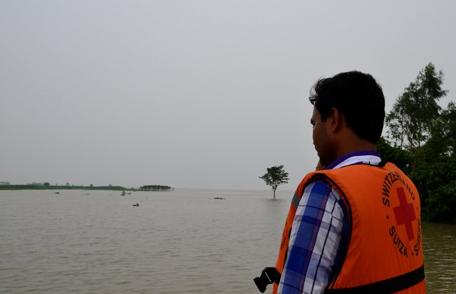
The technology applies to the specific context of the ‘Char’ land in Bangladesh, characterised as riverine sandy Islands along the Jamuna River. More than 80% of the land in the intervention area can be classified as 'Char' and is inhabited by 60% of the population served by the project. Every year, especially during floods, the rivers deposit huge amount of silt sediment that makes the land fertile. At the same time, river action washes away some portion of the 'Char' which at times can be quite large and has a strong impact on people's lives and livelihoods. Before the intervention, people living on 'Char' land depended on their traditional early warning mechanisms and were frequently surprised by floods that destroyed their crops and put their lives in danger. Due to recurring floods, people didn’t have the means to improve their built environment. The 'Char' land is furthermore characterised by its lack of public infrastructure and remoteness to public services.
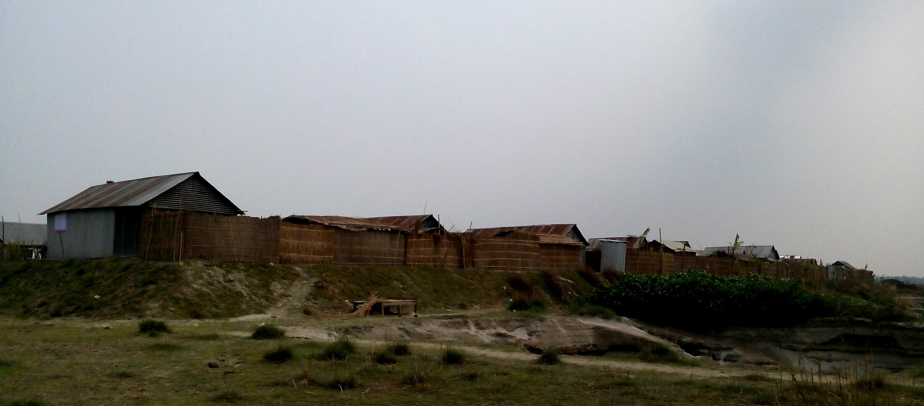
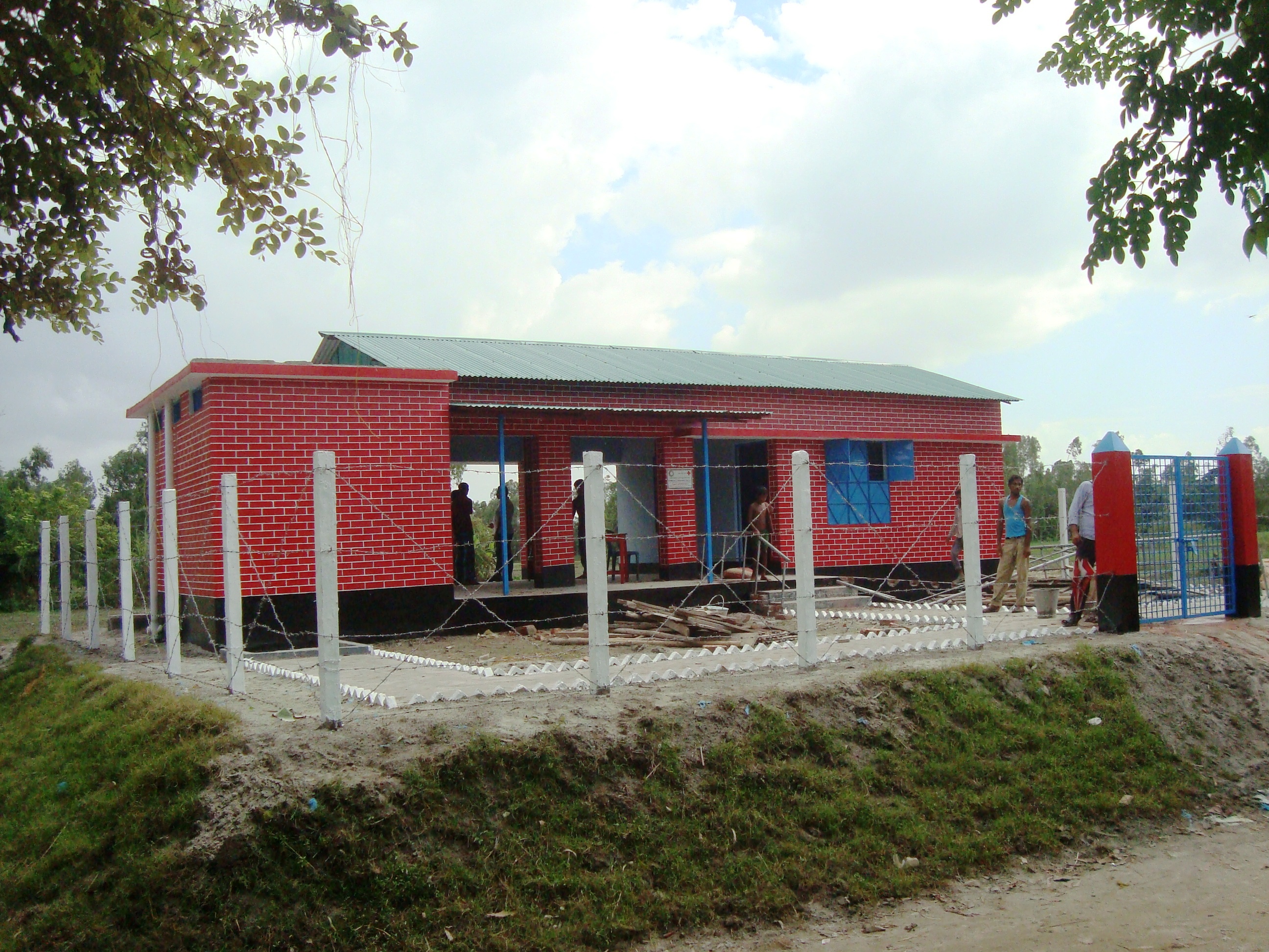
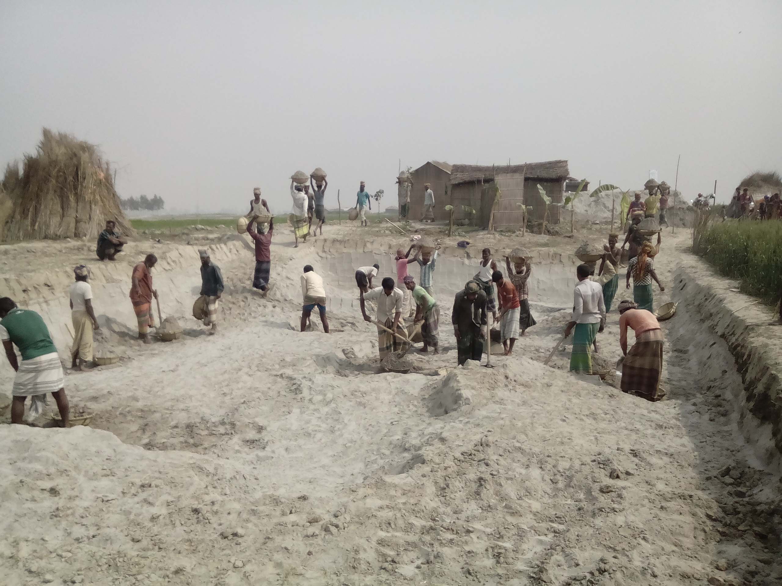
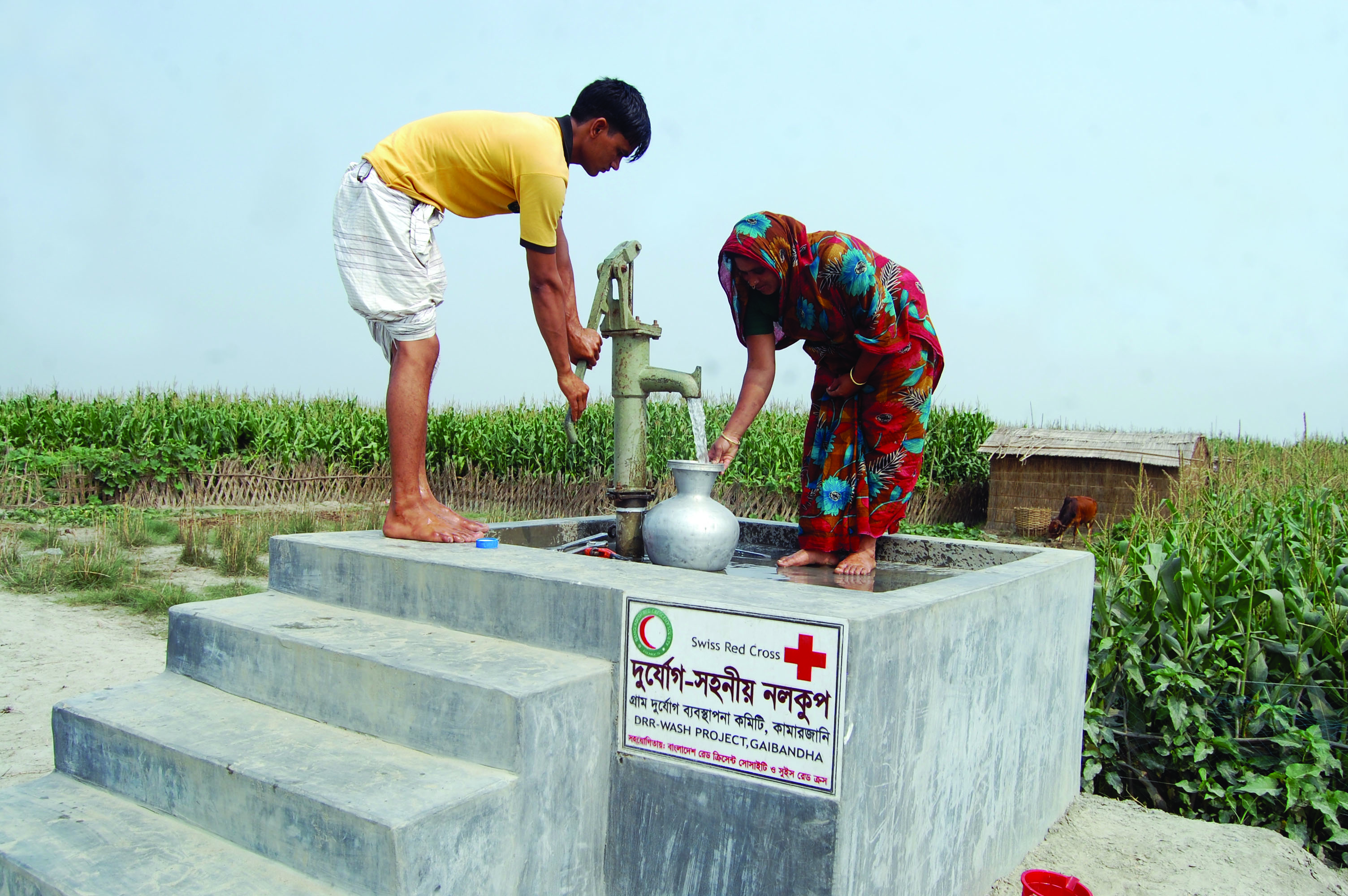
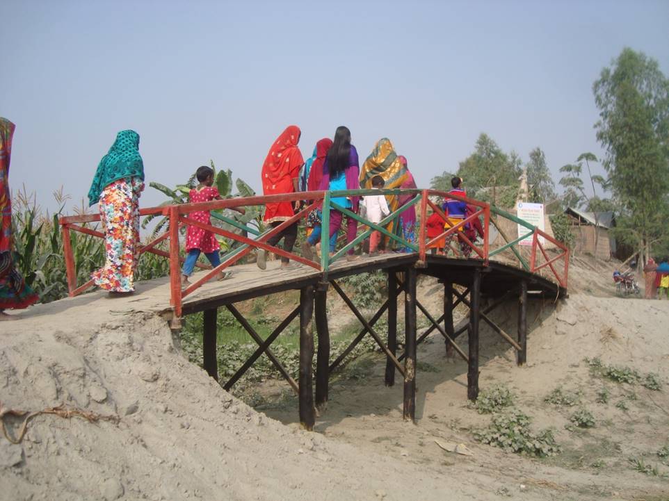
The technology consists of setting up an emergency infrastructure and ensuring community access to these infrastructures during times of floods. It has to be understood in close interrelation with the approach of setting up an early warning system. The emergency infrastructure includes specific flood shelters (for people and animals), flood-proof collective water sources and sanitation systems, transport infrastructure such as foot bridges and elevated rural roads, as well as flood-proof health and school facilities that also serve as emergency shelters during floods. The flood shelters are built on a raised bed of soil and located at sites selected by the communities that are relatively better protected from flood and river erosion within the 'Chars'. The purpose of the technology is to ensure safety of life and protection of assets during times of emergency and also to mitigate sufferings related to floods. The flood shelter is an elevated plane land which is on an average 220 square feet by size and at least five feet high from the existing ground level. The site is selected by the community and should be connected through an elevated road to the nearest community. This arrangement helps people to get easy access during times of floods. The shelter has collective hygienic latrine facilities and safe water sources. People generally dismantle their housing while evacuating and reinstall it on the flood shelter.
The major activities include facilitating the development of community-led risk reduction action plans and their implementation through community participation and engagement of local governance institutions. This includes maintenance of the built infrastructure as the joint responsibility of the community and the local government. Land use, especially sowing and harvesting, is increasingly linked to flood related forecasting measures which has led to significant adaptation in the timing of farming activities. This coupled with the creation and access to emergency infrastructure allows for a relatively safe and healthy living. The adopted technology and approach has led to adapted livelihoods, reduced health costs and increased income. The technology has furthermore led to mainstreaming disaster risk management in policies and approach of local government institutions. Increasingly the local government’s cash and food for work programmes are targeting establishment and/or reinforcement of emergency infrastructure that can cater to larger population. Increased investments are made especially towards flood shelters and improving communication and access to emergency infrastructure. Since the technology is based on local knowledge and has been developed in consultation with the involved communities, it is generally well accepted with a fair degree of ownership and involvement. However, parts of the region are also prone to river erosion and this has a destructive impact on built infrastructures. The technology does not assure any safeguard against this form of uncertain river action.
2.3 ຮູບພາບຂອງເຕັກໂນໂລຢີ
ສື່ຮູບພາບ
ຂໍ້ສັງເກດທົ່ວໄປທີ່ກ່ຽວກັບຮູບພາບ:
Glimpse of few technologies that served as emergency infrastructure, shelter and access to health and water and sanitation facilities.
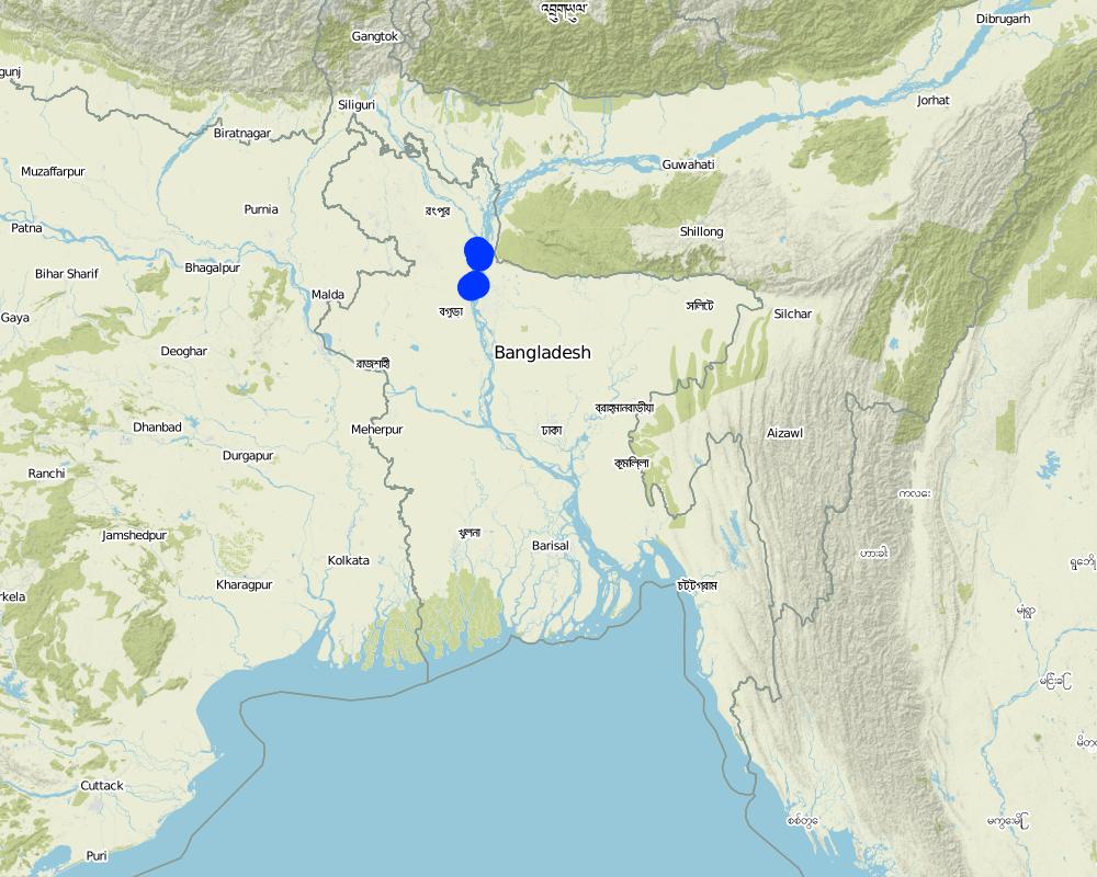
2.5 ປະເທດ / ເຂດ / ສະຖານທີ່ບ່ອນທີ່ ເຕັກໂນໂລຢີ ໄດ້ຮັບການນໍາໃຊ້ ແລະ ທີ່ຖືກປົກຄຸມດ້ວຍການປະເມີນຜົນ
ປະເທດ:
ບັງລາເດດ
ພາກພື້ນ / ລັດ / ແຂວງ:
North-Bengal
ຂໍ້ມູນເພີ່ມເຕີມຂອງສະຖານທີ່:
Kamarjani and Mollar Char Union (i.e. municipality) in Sadar Upazila and Haldia Union in Shaghata Upazila of Gaibandha District
ຄວາມຄິດເຫັນ:
Since the disaster resilient infrastructure set up by the project is installed at a huge number of sites (as indicated in the description above), only a sample of the various emergency infrastructures are indicated on the map above (If needed a comprehensive GPS reading of all infrastructure built by the project can be provided separately).
Map
×2.6 ວັນທີໃນການຈັດຕັ້ງປະຕິບັດ
ໃຫ້ລະບຸປີ ໃນການຈັດຕັ້ງປະຕິບັດ:
2014
ຖ້າຫາກວ່າ ບໍ່ຮູ້ຈັກ ປີທີ່ຊັດເຈນ ແມ່ນໃຫ້ປະມານ ວັນທີເອົາ:
- ຕໍ່າກວ່າ 10 ປີ ຜ່ານມາ (ມາເຖິງປະຈຸບັນ)
2.7 ການນໍາສະເໜີ ເຕັກໂນໂລຢີ
ໃຫ້ລະບຸ ເຕັກໂນໂລຢີ ໄດ້ຖືກຈັດຕັ້ງປະຕິບັດຄືແນວໃດ?
- ເປັນສ່ວນໜື່ງຂອງລະບົບພື້ນເມືອງ (>50 ປີ)
- ໂດຍຜ່ານໂຄງການ / ການຊ່ວຍເຫຼືອຈາກພາຍນອກ
ຄວາມຄິດເຫັນ (ປະເພດ ໂຄງການ ແລະ ອື່ນໆ):
The technology has elements of traditional practice (raised plinths for flood protection) and project promoted interventions (emergency shelter and access infrastructure).
3. ການໃຈ້ແຍກ ເຕັກໂນໂລຢີ ໃນການຄຸ້ມຄອງ ດິນແບບຍືນຍົງ
3.1 ຈຸດປະສົງຫຼັກ (ຫຼາຍ) ຂອງເຕັກໂນໂລຢີ
- ຫຼຸດຜ່ອນຄວາມສ່ຽງ ທາງໄພພິບັດທໍາມະຊາດ
- ສ້າງຜົນກະທົບ ທາງເສດຖະກິດ ທີ່ເປັນປະໂຫຍດ
- ສ້າງຜົນກະທົບ ທີ່ເປັນທາງບວກ ໃຫ້ແກ່ສັງຄົມ
3.2 ປະເພດການນໍາໃຊ້ທີ່ດິນ ໃນປະຈຸບັນ() ທີ່ເຕັກໂນໂລຢີ ໄດ້ຖືກນໍາໃຊ້

ດິນທີ່ປູກພືດ
- ການປູກພືດປະຈໍາປີ
ການປູກພືດຫຼັກ (ທີ່ສາມາດສ້າງລັບຮັບ ເປັນເງິນສົດ ແລະ ເປັນພືດສະບຽງອາຫານ):
Paddy, Wheat, maize, jute, chilli, pulse, sweet potato

ການຕັ້ງຖິ່ນຖານ, ພື້ນຖານໂຄງລ່າງ
- ການຕັ້ງຖິ່ນຖານ, ອາຄານ
- ການຈາລະຈອນ: ຫົນທາງ, ທາງລົດໄຟ
ຄວາມຄິດເຫັນ:
Despite the lack of public infrastructure and services and being exposed to natural hazards people tend to prefer to live in the 'Char' as it brings significant economic benefits for them: crops grow rapidly and abundantly with significantly lower input costs than on the mainland.
3.3 ຂໍ້ມູນເພີ່ມເຕີມກ່ຽວກັບການນໍາໃຊ້ທີ່ດິນ
ການສະໜອງນໍ້າ ໃນພື້ນທີ່ ທີ່ໄດ້ນໍາໃຊ້ ເຕັກໂນໂລຢີ:
- ປະສົມປະສານ ກັນລະຫວ່າງ ນໍ້າຝົນ ແລະ ນໍ້າຊົນລະປະທານ
ຄວາມຄິດເຫັນ:
Water supply for the land comprises a mix of rainfed, irrigated and post flooding sources.
ຈໍານວນ ລະດູການ ປູກໃນປີໜຶ່ງ:
- 3
ລະບຸ ຊະນິດ:
Kharif (monsoon crop), Rabi (winter crop), and Summer/pre-monsoon crop
ຄວາມໜາແໜ້ນ ຂອງສັດລ້ຽງ (ຖ້າຫາກວ່າກ່ຽວຂ້ອງ):
Cow, buffalo, goat, lamb and donkey are very common in the area. People rear these for cultivation, transportation and for having meat. Every household have at least a pair or more of livestock.
3.4 ການນໍາໃຊ້ເຕັກໂນໂລຢີ ທີ່ຢູ່ໃນກຸ່ມການຄຸ້ມຄອງ ທີ່ດິນແບບຍືນຍົງ
- Emergency infrastructure, shelter and linked transportation infrastructure
3.5 ການຂະຫຍາຍເຕັກໂນໂລຢີ
ໃຫ້ລະບຸ ການແຜ່ຂະຫຍາຍ ເຕັກໂນໂລຢີ:
- ແຜ່ຂະຫຍາຍຢ່າງໄວວາໃນພື້ນທີ່
ຖ້າຫາກວ່າ ເຕັກໂນໂລຢີ ໄດ້ແຜ່ຂະຫຍາຍທົ່ວພື້ນທີ່ືື ຢ່າງສະໜ່ຳສະເໝີ, ໃຫ້ລະບຸ ເນື້ອທີ່ ໂດຍການຄາດຄະເນ:
- 1-10 ກມ 2
ຄວາມຄິດເຫັນ:
Though emergency infrastructures are built at specific sites, their use and benefits are evenly spread over an expanded area.
3.6 ມາດຕະການ ການຄຸ້ມຄອງ ທີ່ດິນແບບຍືນຍົງ ປະກອບດ້ວຍ ເຕັກໂນໂລຢີ

ມາດຕະການໂຄງສ້າງ
- S9: ແນວບັງພືດ ແລະ ສັດລ້ຽງ
- S11: ອື່ນໆ

ມາດຕະການ ທາງດ້ານການຄຸ້ມຄອງ
- M4: ການປ່ຽນແປງ ໄລຍະເວລາ ໃນການຈັດຕັ້ງປະຕິບັດ ກິດຈະກໍາ
ຄວາມຄິດເຫັນ:
In addition to the structural and management measures described above, the technology involves additional elements such as flood-proof collective water supply and sanitation systems and communication infrastructure.
3.7 ປະເພດດິນເຊື່ອມໂຊມ ຫຼັກທີ່ໄດ້ນໍາໃຊ້ ເຕັກໂນໂລຢີ

ດິນເຊາະເຈື່ອນ ໂດຍນໍ້າ
- Wr: ແຄມຕາຝັ່ງເຈື່ອນ
- Wo: ຜົນກະທົບ ຂອງການເຊື່ອມໂຊມ ຕໍ່ພື້ນທີ່ພາຍນອກ
ຄວາມຄິດເຫັນ:
N/A
3.8 ການປ້ອງກັນ, ການຫຼຸດຜ່ອນ, ຫຼືການຟື້ນຟູຂອງການເຊື່ອມໂຊມຂອງດິນ
ໃຫ້ລະບຸ ເປົ້າໝາຍ ເຕັກໂນໂລຢີ ທີ່ພົວພັນ ກັບຄວາມເຊື່ອມໂຊມຂອງດິນ:
- ປັບຕົວຕໍ່ການເຊື່ອມໂຊມຂອງດິນ
ຄວາມຄິດເຫັນ:
NA
4. ຂໍ້ກໍາໜົດ, ກິດຈະກໍາການປະຕິບັດ, ວັດຖຸດິບ, ແລະຄ່າໃຊ້ຈ່າຍ
4.1 ເຕັກນິກ ໃນການແຕ້ມແຜນວາດ ເຕັກໂນໂລຢີ
ຜູ້ຂຽນ:
Abdur Razzak
ວັນທີ:
17/10/2016
ຜູ້ຂຽນ:
Abdur Razzak
ວັນທີ:
31/07/2016
4.2 ການແຕ້ມແຜນວາດອະທິບາຍເຕັກນິກ
The built structural mitigation options have following technical specification:
1. Flood shelter: Dimension: Length-220' x Width-220' x Height- 5.5', Slope: 1:1.5, Capacity: 350 families, Construction material used: soil and turfing (grass)
2. Raised school compound: Dimension: Length-112' x Width-75' x Height- 5.5', Slope: 1:1.5, Capacity: 540 person, Construction material used: soil and turfing (grass)
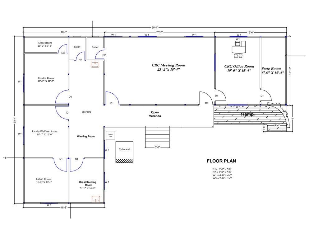
3. Community Resource Centre and Community Clinic (CRC-CC): Dimension: Length-60' x Width-38' x Height- 5.6', Slope: 1:1.5, Capacity: 1500 families from 5 villages, Construction material used: soil and grass plantation, bricks, sand, cement, rod, iron angel and CGI sheet.
4. Disaster resilient tube well: Dimension: Length-5' 10" x Width-5' x Height- 3', Boring: 100 feet, Capacity: 200 families, Construction material used: bricks, sand, cement, rod, tube well head, pvc pipe, cylinder, piston rod etc. Vertical intervals: 2 in each village.
5. Concrete platform for (existing) tube well: Dimension: Length-4' 10" x Width-4' x Height- 1', Capacity: 100 families, Construction material used: bricks, sand, cement, pvc pipe
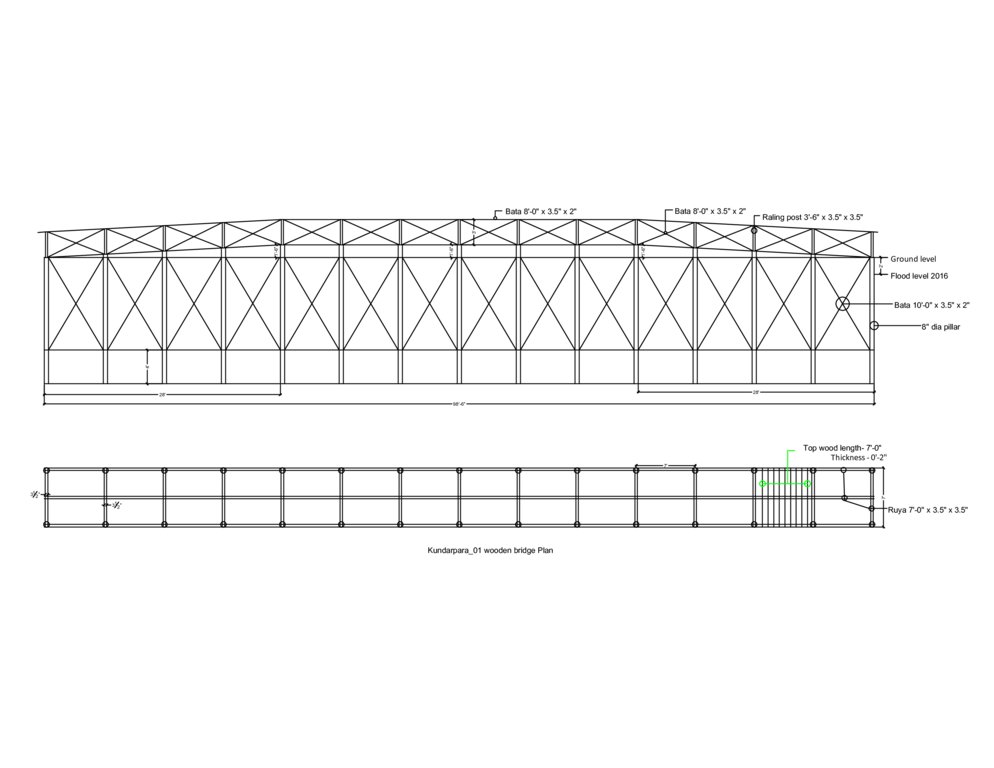
6. Wooden bridge: Dimension: Length-99' x Width-7' x Height- 12', Slope: 1:1.5, Capacity: 900 families approximately, Construction material used: wood, nails, tar, soil and grass plantation
7. Road construction/repair: Dimension: Length-925' x Width-12' x Height- 3' (from existing level), Slope: 1:1.5, Capacity: 3 villages (approx:1000 families), Construction material used: soil and turfing (grass).
4.3 ຂໍ້ມູນທົ່ວໄປກ່ຽວກັບການຄິດໄລ່ປັດໃຈຂາເຂົ້າໃນການຜະລິດ ແລະ ມູນຄ່າອື່ນໆ
ລະບຸ ວິທີການ ຄຳໃຊ້ຈ່າຍ ແລະ ປັດໄຈນໍາເຂົ້າ ທີ່ໄດ້ຄິດໄລ່:
- ຕໍ່ຫົວໜ່ວຍ ທີ່ໄດ້ຈັດຕັ້ງປະຕິບັດ ເຕັກໂນໂລຢີ
ໃຫ້ລະບຸຫົວໜ່ວຍ:
flood shelter, raised school compound, disaster resilient tube well, concrete platform for (existing) tube well, wooden bridge, road construction/repair
ລະບຸປະລິມານ, ຄວາມຍາວ ແລະ ອື່ນໆ (ຖ້າຫາກວ່າກ່ຽວຂ້ອງ):
road: per meter
ສະກຸນເງິນອື່ນໆ / ປະເທດອື່ນໆ (ລະບຸ):
Bangladeshi Taka (BDT)
ລະບຸ ອັດຕາແລກປ່ຽນ ຈາກໂດລາ ເປັນເງິນຕາທ້ອງຖີ່ນ (ຖ້າກ່ຽວຂ້ອງ): 1 ໂດລາ =:
79.0
ລະບຸ ຄ່າຈ້າງ ຄ່າແຮງງານສະເລ່ຍ ຕໍ່ ວັນ:
350 BDT
4.4 ການສ້າງຕັ້ງກິດຈະກໍາ
| ກິດຈະກໍາ | ປະເພດ ມາດຕະການ | ໄລຍະເວລາ | |
|---|---|---|---|
| 1. | Construction of Flood Shelter | ໂຄງສ້າງ | During dry season |
| 2. | Raising school compound | ໂຄງສ້າງ | During dry season |
| 3. | Construction of Community Resource Center (CRC) | ໂຄງສ້າງ | During dry season |
| 4. | Installation of disaster resilient tube well | ໂຄງສ້າງ | During dry season |
| 5. | Construction of concrete platform for (existing) tube well | ໂຄງສ້າງ | During dry season |
| 6. | Construction of wooden bridge | ໂຄງສ້າງ | During dry season |
| 7. | Road construction above flood level | ໂຄງສ້າງ | During dry season |
ຄວາມຄິດເຫັນ:
All activities are structural in nature and can be undertaken efficiently only in dry season.
4.5 ຕົ້ນທຶນ ແລະ ປັດໄຈຂາເຂົ້າທີ່ຈໍາເປັນໃນຈັດຕັ້ງປະຕິບັດ
| ລະບຸ ປັດໃຈ ນໍາເຂົ້າ ໃນການຜະລີດ | ຫົວໜ່ວຍ | ປະລິມານ | ຕົ້ນທຶນ ຕໍ່ຫົວໜ່ວຍ | ຕົ້ນທຶນທັງໝົດ ຂອງປັດໃຈຂາເຂົ້າ ໃນການຜະລິດ | % ຂອງຕົ້ນທຶນທັງໝົດ ທີ່ຜູ້ນໍາໃຊ້ທີ່ດິນ ໃຊ້ຈ່າຍເອງ | |
|---|---|---|---|---|---|---|
| ແຮງງານ | Flood shelter: earth work | m3 | 8000.0 | 64.0 | 512000.0 | 10.0 |
| ແຮງງານ | CRC: earth work | m3 | 53.0 | 138.0 | 7314.0 | 10.0 |
| ແຮງງານ | CRC: sand filling | m3 | 302.0 | 99.0 | 29898.0 | 10.0 |
| ແຮງງານ | Raised school compound: earth work | m3 | 1790.0 | 64.0 | 114560.0 | 10.0 |
| ວັດສະດຸໃນການປູກ | Flood shelter: grass plantation (turfing) | m2 | 4620.0 | 13.0 | 60060.0 | 10.0 |
| ວັດສະດຸໃນການປູກ | Flood shelter: seedlings | piece | 20.0 | 53.0 | 1060.0 | 10.0 |
| ວັດສະດຸໃນການປູກ | CRC: grass plantation (turfing) | m2 | 3890.0 | 13.0 | 50570.0 | 10.0 |
| ວັດສະດຸໃນການປູກ | CRC: seedlings | piece | 50.0 | 53.0 | 2650.0 | 10.0 |
| ວັດສະດຸໃນການປູກ | Raised school compound: grass plantation (turfing) | m2 | 1390.0 | 13.0 | 18070.0 | 10.0 |
| ວັດສະດຸໃນການປູກ | Raised school compound: seedlings | piece | 40.0 | 53.0 | 2120.0 | 10.0 |
| ວັດສະດຸກໍ່ສ້າງ | CRC: roof truss | kg | 4375.0 | 100.0 | 437500.0 | |
| ວັດສະດຸກໍ່ສ້າງ | CRC: grill and iron work | m2 | 88.0 | 2091.0 | 184008.0 | |
| ວັດສະດຸກໍ່ສ້າງ | CRC: gypsum board | m2 | 478.0 | 922.0 | 440716.0 | |
| ວັດສະດຸກໍ່ສ້າງ | CRC: RCC work | m3 | 2.9 | 19557.0 | 56715.3 | |
| ວັດສະດຸກໍ່ສ້າງ | CRC: deformed bar | kg | 397.0 | 85.0 | 33745.0 | |
| ວັດສະດຸກໍ່ສ້າງ | CRC: boundary fencing | m2 | 184.0 | 440.0 | 80960.0 | |
| ວັດສະດຸກໍ່ສ້າງ | CRC: brick work | m3 | 44.0 | 5515.0 | 242660.0 | |
| ອື່ນໆ | CRC: electric ware and solar panel | lumpsum | 1.0 | 73000.0 | 73000.0 | |
| ອື່ນໆ | CRC: water supply | lumpusm | 1.0 | 66150.0 | 66150.0 | |
| ອື່ນໆ | CRC: transportation | lumpsum | 1.0 | 89000.0 | 89000.0 | |
| ຕົ້ນທຶນທັງໝົດ ໃນການຈັດຕັ້ງປະຕິບັດ ເຕັກໂນໂລຢີ | 2502756.3 | |||||
ຖ້າຫາກຜູ້ນຳໃຊ້ທີ່ດິນ ນຳໃຊ້ມູນຄ່າຕ່ຳກວ່າ 100% ໃຫ້ລະບຸ ແມ່ນໃຜເປັນຜູ້ຊ່ວຍ ໃນລາຍຈ່າຍທີ່ເຫຼືອ:
10% of all construction cost (except community resource center) is borne by the user. Another 15% is provided by the local government bodies. The remaining 75% is subsidised by the project.
ຄວາມຄິດເຫັນ:
Defining costs of establishment is bit tricky as the measures differ in size and number, costs vary from one village to another depending on the geographical location. However, average costs of the measures further to those highligted in the table are given below:
Disaster resilient tube well: labour (mason) 3'000, equipment (drilling charge) 1800, construction material (bricks, cement, sand, iron rod, PVC pipe, cylinder, GI pipe, tubewell head) 23'250, transportation 2'650, total unit costs (BDT) 30'700
Concrete platform for (existing) tube well : labour (mason) 600, construction material (bricks, cement, sand) 2'450, other (Transportation, waste water disposal) 1650, total unit costs (BDT) 4'700
Wooden bridge: labour (mason, mason assitant, painting assistant, earthwork) 30'000, plant material (grass plantation) 12'500, equipment (painting brush etc.) 1'000, construction material (timber, nails, tar, tarpin oil, paint) 260'000, Transportation 30'000, total unit costs (BDT) 333'500
Road construction/repair: labour (earthwork) 102'500, plant material (grass plantation/turfing), 12'500, total unit costs (BDT) 115'000
4.6 ບໍາລຸງຮັກສາ / ແຜນຈັດຕັ້ງປະຕິບັດ ກິດຈະກໍາ
| ກິດຈະກໍາ | ປະເພດ ມາດຕະການ | ໄລຍະເວລາ / ຄວາມຖີ່ | |
|---|---|---|---|
| 1. | Construction of Flood Shelter | ໂຄງສ້າງ | During dry season |
| 2. | Raising school compound | ໂຄງສ້າງ | During dry season |
| 3. | Construction of Community Resource Center (CRC) | ໂຄງສ້າງ | During dry season |
| 4. | Installation of disaster resilient tube well | ໂຄງສ້າງ | During dry season |
| 5. | Construction of concrete platform ror (existing) tube well | ໂຄງສ້າງ | During dry season |
| 6. | Construction of wooden bridge | ໂຄງສ້າງ | During dry season |
| 7. | Road construction above flood level | ໂຄງສ້າງ | During dry season |
ຄວາມຄິດເຫັນ:
Due to the softness of the sandy soil and the annual inundation, every measure requires considerable maintenance. The flooding generally washes out sands and decays the foundation of the structure. If maintenance is done in regular intervals, the entire structure remains functional. Also, grass needs to be frequently replanted as it dries up during the dry season.
The users and the local government (Union Disaster Management Committee) are mainly responsible for maintenance of all built assets and structures including the Community Resource Center. The relevant operation/repair and maintenance training has been provided by the project.. Maintenance manuals and guidelines have been developed and disseminated. Also, repair and maintenance equipment has been provided to cadre of users/caretakers trained in repair/maintenance work.
4.7 ຄ່າໃຊ້ຈ່າຍ ແລະ ປັດໄຈນໍາເຂົ້າທີ່ຈໍາເປັນສໍາລັບການບໍາລຸງຮັກສາກິດຈະກໍາ / ແຜນປະຕິບັດ (ຕໍ່ປີ)
| ລະບຸ ປັດໃຈ ນໍາເຂົ້າ ໃນການຜະລີດ | ຫົວໜ່ວຍ | ປະລິມານ | ຕົ້ນທຶນ ຕໍ່ຫົວໜ່ວຍ | ຕົ້ນທຶນທັງໝົດ ຂອງປັດໃຈຂາເຂົ້າ ໃນການຜະລິດ | % ຂອງຕົ້ນທຶນທັງໝົດ ທີ່ຜູ້ນໍາໃຊ້ທີ່ດິນ ໃຊ້ຈ່າຍເອງ | |
|---|---|---|---|---|---|---|
| ແຮງງານ | Earthwork | m3 | 80.0 | 63.0 | 5040.0 | 10.0 |
| ແຮງງານ | Sand bag filling | piece | 50.0 | 15.0 | 750.0 | 10.0 |
| ແຮງງານ | Pipe fitting | piece | 2.0 | 300.0 | 600.0 | 10.0 |
| ແຮງງານ | Mason | lumpsum | 1.0 | 500.0 | 500.0 | 10.0 |
| ວັດສະດຸໃນການປູກ | Grass plantation (turfing) | m2 | 85.0 | 13.0 | 1105.0 | 10.0 |
| ວັດສະດຸໃນການປູກ | Seedlings | piece | 15.0 | 53.0 | 795.0 | 10.0 |
| ວັດສະດຸກໍ່ສ້າງ | Plastic bag | piece | 50.0 | 10.0 | 500.0 | 10.0 |
| ວັດສະດຸກໍ່ສ້າງ | PVC pipe | m | 15.0 | 120.0 | 1800.0 | 10.0 |
| ວັດສະດຸກໍ່ສ້າງ | Polythene pipe | kg | 5.0 | 160.0 | 800.0 | 10.0 |
| ວັດສະດຸກໍ່ສ້າງ | Ciment | bag | 0.5 | 540.0 | 270.0 | 10.0 |
| ວັດສະດຸກໍ່ສ້າງ | Sand | ft3 | 5.0 | 18.0 | 90.0 | 10.0 |
| ວັດສະດຸກໍ່ສ້າງ | Caping socket | piece | 2.0 | 35.0 | 70.0 | 10.0 |
| ວັດສະດຸກໍ່ສ້າງ | Tape etc. | lumpsum | 1.0 | 250.0 | 250.0 | 10.0 |
| ຕົ້ນທຶນທັງໝົດ ທີ່ໃຊ້ໃນການບໍາລຸງຮັກສາ ເຕັກໂນໂລຢີ | 12570.0 | |||||
ຖ້າຫາກຜູ້ນຳໃຊ້ທີ່ດິນ ນຳໃຊ້ມູນຄ່າຕ່ຳກວ່າ 100% ໃຫ້ລະບຸ ແມ່ນໃຜເປັນຜູ້ຊ່ວຍ ໃນລາຍຈ່າຍທີ່ເຫຼືອ:
Maintenance costs are to date (2017) distributed as construction (10% by the users, 15% by the local government). A cost transfer scheme to the users and local government for maintenance is developped to be applied in the follow-up phase.
ຄວາມຄິດເຫັນ:
Again, defining costs of maintenance is also not easy as the measures differ in size and number. Average costs of the measures, further to those for flood shelter including disaster resilient tube well as highligted in the table, are given below:
Raised school compound: labour (earth work and sand bag filling) 7'800, plant material (grass plantation) 1'000, construction material (plastic bag, rope) 500, total unit maintenance costs (BDT) 9'300
Community resource Center (CRC): labour 1'200, plant material (grass plantation, seedlings) 10'500, Transportation 1'000, total unit maintenance costs (BDT) 12'700
Concrete platform for (existing) tube well : labour (mason) 500, construction material (bricks, cement, sand) 600, total unit maintenance costs (BDT) 1'100
Wooden bridge: labour (earthwork) 2'500, plant material (grass plantation) 3'000, construction material (plastic bag, rope) 2'000, total unit maintenance costs (BDT) 7'500
Road construction/repair: labour (earthwork) 10'000, plant material (grass plantation/turfing), 1'500, construction material (plastic bag, rope) 500, total unit maintenance costs (BDT) 12'000
4.8 ປັດໄຈ ທີ່ສໍາຄັນ ທີ່ສົ່ງຜົນກະທົບ ຕໍ່ຄ່າໃຊ້ຈ່າຍ
ໃຫ້ອະທິບາຍ ປັດໃຈ ທີ່ສົ່ງຜົນກະທົບ ຕໍ່ຕົ້ນທຶນ ໃນການຈັດຕັ້ງປະຕິບັດ:
Transportation of raw material from the mainland to the sites on the 'Char' Islands varies across seasons. In the dry season it is much higher compared to monsoon as the delivery of material is easier in the latter due to extended river outreach.
5. ສະພາບແວດລ້ອມທໍາມະຊາດ ແລະ ມະນຸດ
5.1 ອາກາດ
ປະລິມານນໍ້າຝົນປະຈໍາປີ
- < 250 ມີລິແມັດ
- 251-500 ມີລິແມັດ
- 501-750 ມີລິແມັດ
- 751-1,000 ມີລິແມັດ
- 1,001-1,500 ມີລິແມັດ
- 1,501-2,000 ມີລິແມັດ
- 2,001-3,000 ມີລິແມັດ
- 3,001-4,000 ມີລິແມັດ
- > 4,000 ມີລິແມັດ
ໃຫ້ລະບຸສະເລ່ຍ ປະລິມານນໍ້າຝົນຕົກປະຈໍາປີ ເປັນມິນລິແມັດ (ຖ້າຫາກຮູ້ຈັກ):
2134.80
ຂໍ້ມູນສະເພາະ / ຄວາມເຫັນກ່ຽວກັບ ປະລິມານນໍ້າຝົນ:
Rainy season: April- October
Occurrence of heavy rain: June-July
Length of dry period: November-March
ໃຫ້ລະບຸ ຊື່ສະຖານີ ອຸຕຸນິຍົມ ເພື່ອເປັນຂໍ້ມູນອ້າງອີງ:
18 Gaibandha Sadar, Gaibandha
ເຂດສະພາບອາກາດກະສິກໍາ
- ຄວາມຊຸ່ມ
Tropical humid climatic zone.
Temperature: maximum 33.5°C, minimum 10.5°C
5.2 ພູມິປະເທດ
ຄ່າສະເລ່ຍ ຄວາມຄ້ອຍຊັນ:
- ພື້ນທີ່ຮາບພຽງ (0-2%)
- ອ່ອນ (3-5 %)
- ປານກາງ (6-10 %)
- ມ້ວນ (11-15 %)
- ເນີນ(16-30%)
- ໍຊັນ (31-60%)
- ຊັນຫຼາຍ (>60%)
ຮູບແບບຂອງດິນ:
- ພູພຽງ / ທົ່ງພຽງ
- ສັນພູ
- ເປີ້ນພູ
- ເນີນພູ
- ຕີນພູ
- ຮ່ອມພູ
ເຂດລະດັບສູງ:
- 0-100 ແມັດ a.s.l.
- 101-500 ແມັດ a.s.l.
- 501-1,000 ແມັດ a.s.l.
- 1,001-1,500 ແມັດ a.s.l.
- 1,501-2,000 ແມັດ a.s.l.
- 2,001-2,500 ແມັດ a.s.l.
- 2,501-3,000 ແມັດ a.s.l.
- 3,001-4,000 ແມັດ a.s.l.
- > 4,000 ແມັດ a.s.l.
ໃຫ້ລະບຸ ເຕັກໂນໂລຢີ ທີ່ໄດ້ຖືກນຳໃຊ້:
- ບໍ່ກ່ຽວຂ້ອງ
ຄຳເຫັນ ແລະ ຂໍ້ມູນສະເພາະ ເພີ່ມເຕີມ ກ່ຽວກັບ ພູມີປະເທດ:
Information on altitudinal zone collected from the website: www.getamap.net
5.3 ດິນ
ຄວາມເລິກ ຂອງດິນສະເລ່ຍ:
- ຕື້ນຫຼາຍ (0-20 ຊັງຕີແມັດ)
- ຕື້ນ (21-50 ຊຕມ)
- ເລີກປານກາງ (51-80 ຊຕມ)
- ເລິກ (81-120 ຊມ)
- ເລິກຫຼາຍ (> 120 cm)
ເນື້ອດິນ (ໜ້າດິນ):
- ປານກາງ (ດິນໜຽວ, ດິນໂຄນ)
- ບາງລະອຽດ / ໜັກ (ໜຽວ)
ເນື້ອດິນ (ເລິກຈາກໜ້າດິນ ລົງໄປຫຼາຍກວ່າ 20 ຊັງຕິແມັດ):
- ຫຍາບ / ເບົາ (ດິນຊາຍ)
- ປານກາງ (ດິນໜຽວ, ດິນໂຄນ)
ຊັ້ນອິນຊີວັດຖຸ ເທິງໜ້າດິນ:
- ປານກາງ (1-3 %)
ຖ້າເປັນໄປໄດ້ ແມ່ນໃຫ້ຕິດຄັດ ການພັນລະນາດິນ ຫຼື ຂໍ້ມູນສະເພາະຂອງດິນ, ຕົວຢ່າງ, ຄຸນລັກສະນະ ປະເພດຂອງດິນ, ຄ່າຄວາມເປັນກົດ / ເປັນດ່າງຂອງດິນ, ສານອາຫານ, ດິນເຄັມ ແລະ ອື່ນໆ.
N/A
5.4 ມີນໍ້າ ແລະ ຄຸນນະພາບ
ລະດັບ ນໍ້າໃຕ້ດິນ:
5-50 ແມັດ
ການມີນໍ້າ ເທິງໜ້າດິນ:
ປານກາງ
ຄຸນນະພາບນໍ້າ (ບໍ່ມີການບໍາບັດ):
ມີນໍ້າດື່ມ
ມີບັນຫາ ກ່ຽວກັບນໍ້າເຄັມບໍ່?
ບໍ່ແມ່ນ
ເກີດມີນໍ້າຖ້ວມ ໃນພື້ນທີ່ບໍ່?
ແມ່ນ
ເປັນປົກກະຕິ:
ເລື້ອຍໆ
ຄວາມຄິດເຫັນ ແລະ ຂໍ້ກໍານົດ ເພີ່ມເຕີມ ກ່ຽວກັບ ຄຸນນະພາບ ແລະ ປະລິມານ ຂອງນ້ຳ:
In the dry season water crisis occurs. Open defecation and use of pesticide in farming are key pollutants of water sources.
5.5 ຊີວະນາໆພັນ
ຄວາມຫຼາກຫຼາຍ ທາງສາຍພັນ:
- ປານກາງ
ຄວາມຫຼາກຫຼາຍ ທາງດ້ານ ທີ່ຢູ່ອາໃສ ຂອງສິ່ງທີ່ມີຊີວິດ:
- ປານກາງ
ຄວາມຄິດເຫັນ ແລະ ລັກສະນະສະເພາະ ເພີ່ມເຕີມກ່ຽວກັບ ຊີວະນາໆພັນ:
Biodiversity can be rated as moderate or medium both in terms of species and habitat. It is stable and and often self generating.
5.6 ຄຸນລັກສະນະ ຂອງຜູ້ນໍາໃຊ້ທີ່ດິນ ທີ່ໄດ້ນໍາໃຊ້ເຕັກໂນໂລຢີ
ຢູ່ປະຈຳ ຫຼື ເຄື່ອນຍ້າຍຕະຫຼອດ:
- ບໍ່ເຄື່ອນໄຫວ
- ແບບເຄີ່ງຂັງ-ເຄີ່ງປ່ອຍ
ລະບົບ ການຕະຫຼາດ ແລະ ຜົນຜະລິດ:
- ປະສົມ (ກຸ້ມຕົນເອງ / ເປັນສິນຄ້າ
ລາຍຮັບ ທີ່ບໍ່ໄດ້ມາຈາກ ການຜະລິດ ກະສິກໍາ:
- ໜ້ອຍກ່ວາ 10 % ຂອງລາຍຮັບທັງໝົດ
ລະດັບຄວາມຮັ່ງມີ:
- ທຸກຍາກ
ບຸກຄົນ ຫຼື ກຸ່ມ:
- ບຸກຄົນ / ຄົວເຮືອນ
- ກຸ່ມ / ຊຸມຊົນ
ລະດັບ ການຫັນເປັນກົນຈັກ:
- ສັດລາກແກ່
- ເຄື່ອງກົນຈັກ
ເພດ:
- ຜູ້ຍິງ
- ຜູ້ຊາຍ
ອາຍຸ ຂອງຜູ້ນໍາໃຊ້ທີ່ດິນ:
- ຊາວໜຸ່ມ
- ໄວກາງຄົນ
ໃຫ້ລະບຸ ຄຸນລັກສະນະ ຂອງຜູ້ນໍາໃຊ້ທີ່ດິນ:
N/A
5.7 ພື້ນທີ່ສະເລ່ຍຂອງທີ່ດິນ ຫຼື ເຊົ່າໂດຍຜູ້ໃຊ້ທີ່ດິນການນໍາໃຊ້ ເຕັກໂນໂລຢີ
- <0.5 ເຮັກຕາ
- 0.5-1 ເຮັກຕາ
- 1-2 ເຮັກຕາ
- 2-5 ເຮັກຕາ
- 5-15 ເຮັກຕາ
- 15-50 ເຮັກຕາ
- 50-100 ເຮັກຕາ
- 100-500 ເຮັກຕາ
- 500-1,000 ເຮັກຕາ
- 1,000-10,000 ເຮັກຕາ
- > 10,000 ເຮັກຕາ
ຖືໄດ້ວ່າ ເປັນຂະໜາດນ້ອຍ, ກາງ ຫຼື ໃຫຍ່ (ອີງຕາມເງື່ອນໄຂ ສະພາບຄວາມເປັນຈິງ ຂອງທ້ອງຖີ່ນ)? :
- ຂະໜາດນ້ອຍ
ຄວາມຄິດເຫັນ:
People living in Chars have small landholding which often produces enough for subsistence and, in some cases, for market purposes.
5.8 ເຈົ້າຂອງທີ່ດິນ, ສິດໃຊ້ທີ່ດິນ, ແລະ ສິດທິການນໍາໃຊ້ນໍ້າ
ເຈົ້າຂອງດິນ:
- ລັດ
- ບຸກຄົນ, ບໍ່ມີຕໍາແໜ່ງ
ສິດທິ ໃນການນໍາໃຊ້ທີ່ດິນ:
- ເປີດກວ້າງ (ບໍ່ມີການຈັດຕັ້ງ)
- ເຊົ່າ
ສິດທິ ໃນການນໍາໃຊ້ນໍ້າ:
- ຊຸມຊົນ (ທີ່ມີການຈັດຕັ້ງ)
- ບຸກຄົນ
ຄວາມຄິດເຫັນ:
Land ownership is quite complex as Chars by nature are unstable habitats. In principle land is owned by state but in most cases the politician - musclemen nexus exercises real control. This results in leasing and renting of land which is the predominant form of land ownership in Chars.
5.9 ການເຂົ້າເຖິງການບໍລິການ ແລະ ພື້ນຖານໂຄງລ່າງ
ສຸຂະພາບ:
- ທຸກຍາກ
- ປານກາງ
- ດີ
ການສຶກສາ:
- ທຸກຍາກ
- ປານກາງ
- ດີ
ການຊ່ວຍເຫຼືອ ດ້ານວິຊາການ:
- ທຸກຍາກ
- ປານກາງ
- ດີ
ການຈ້າງງານ (ຕົວຢ່າງ, ການເຮັດກິດຈະກໍາອື່ນ ທີ່ບໍ່ແມ່ນ ການຜະລິດກະສິກໍາ):
- ທຸກຍາກ
- ປານກາງ
- ດີ
ຕະຫຼາດ:
- ທຸກຍາກ
- ປານກາງ
- ດີ
ພະລັງງານ:
- ທຸກຍາກ
- ປານກາງ
- ດີ
ຖະໜົນຫົນທາງ ແລະ ການຂົນສົ່ງ:
- ທຸກຍາກ
- ປານກາງ
- ດີ
ການດື່ມນໍ້າ ແລະ ສຸຂາພິບານ:
- ທຸກຍາກ
- ປານກາງ
- ດີ
ການບໍລິການ ທາງດ້ານການເງິນ:
- ທຸກຍາກ
- ປານກາງ
- ດີ
Access to mobile phone and internet:
- ທຸກຍາກ
- ປານກາງ
- ດີ
6. ຜົນກະທົບ ແລະ ລາຍງານສະຫຼຸບ
6.1 ການສະແດງຜົນກະທົບ ພາຍໃນພື້ນທີ່ ທີ່ໄດ້ຈັດຕັ້ງປະຕິບັດ ເຕັກໂນໂລຢີ
ຜົນກະທົບທາງເສດຖະກິດສັງຄົມ
ການຜະລິດ
ການຜະລິດພືດ
ປະລິມານ ກ່ອນການຈັດຕັ້ງປະຕິບັດ ການຄຸ້ມຄອງ ທີ່ດິນແບບຍືນຍົງ:
3600 kg/hectare (maize)
ປະລີມານ ຫຼັງການຈັດຕັ້ງປະຕິບັດ ການຄຸ້ມຄອງ ທີ່ດິນແບບຍືນຍົງ:
11400 kg/hectare (maize)
ຄວາມຄິດເຫັນ / ລະບຸແຈ້ງ:
Crop production has increased thrice due to stability of household which has led to stable use of land in the chars.
ມີນໍ້າ ແລະ ຄຸນນະພາບ
ມີນໍ້າດື່ມ
ປະລິມານ ກ່ອນການຈັດຕັ້ງປະຕິບັດ ການຄຸ້ມຄອງ ທີ່ດິນແບບຍືນຍົງ:
No safe drinking water source was available
ປະລີມານ ຫຼັງການຈັດຕັ້ງປະຕິບັດ ການຄຸ້ມຄອງ ທີ່ດິນແບບຍືນຍົງ:
More than 40% water source are safe
ຄວາມຄິດເຫັນ / ລະບຸແຈ້ງ:
Collective water supply systems have groundwater sources and thus no treatment is needed. Further, aspects of availability, easy access and sustainable availability of sufficient water of acceptable quality are well considered. Families can access 10 litres per capita per day (LPCD) during emergencies (which is in line with Sphere standards) and during normal times 40 LPCD is what families can collect from these water sources. All such water sources are within a distance of 50 metres from the settlement as per Bangladesh standards.
ນໍ້າດື່ມ ມີຄຸນນະພາບ
ປະລິມານ ກ່ອນການຈັດຕັ້ງປະຕິບັດ ການຄຸ້ມຄອງ ທີ່ດິນແບບຍືນຍົງ:
Reliable data not available
ປະລີມານ ຫຼັງການຈັດຕັ້ງປະຕິບັດ ການຄຸ້ມຄອງ ທີ່ດິນແບບຍືນຍົງ:
All households have access to safe drinking water as per govt. standard for rural areas
ຄວາມຄິດເຫັນ / ລະບຸແຈ້ງ:
The collective water infrastructure built by the project ensures fulfillment of minimum standards set by the govt for safe drinking water.
ລາຍໄດ້ ແລະ ຄ່າໃຊ້ຈ່າຍ
ລາຍຮັບ ຈາກການຜະລີດ
ປະລິມານ ກ່ອນການຈັດຕັ້ງປະຕິບັດ ການຄຸ້ມຄອງ ທີ່ດິນແບບຍືນຍົງ:
25% families had farm income
ປະລີມານ ຫຼັງການຈັດຕັ້ງປະຕິບັດ ການຄຸ້ມຄອງ ທີ່ດິນແບບຍືນຍົງ:
95% families have farm income
ຄວາມຄິດເຫັນ / ລະບຸແຈ້ງ:
Cattle and poultries are safe during disaster
ຜົນກະທົບດ້ານວັດທະນາທໍາສັງຄົມ
ສະພາບທາງດ້ານສຸຂະພາບ
ຄວາມຄິດເຫັນ / ລະບຸແຈ້ງ:
The disaster mitigation measures has significantly improved the health situation of the target population.
ສະຖາບັນ ການຈັດຕັ້ງຊຸມຊົນ
ປະລິມານ ກ່ອນການຈັດຕັ້ງປະຕິບັດ ການຄຸ້ມຄອງ ທີ່ດິນແບບຍືນຍົງ:
Few credit groups in intervention villages
ປະລີມານ ຫຼັງການຈັດຕັ້ງປະຕິບັດ ການຄຸ້ມຄອງ ທີ່ດິນແບບຍືນຍົງ:
30 community based organisatons (i.e. village disaster management committees) and 3 Local Government Committees (Union disaster management committee)
ຄວາມຄິດເຫັນ / ລະບຸແຈ້ງ:
Community based organisations and government mandated institutions have been promoted through project initiatives.
ສະຖາບັນແຫ່ງຊາດ
ຄວາມຄິດເຫັນ / ລະບຸແຈ້ງ:
CRC is also being used for UDMC office which is an important committee of union parishad.
ການຫຼຸດຜ່ອນ ຂໍ້ຂັດແຍ່ງ
ປະລິມານ ກ່ອນການຈັດຕັ້ງປະຕິບັດ ການຄຸ້ມຄອງ ທີ່ດິນແບບຍືນຍົງ:
Widespread
ປະລີມານ ຫຼັງການຈັດຕັ້ງປະຕິບັດ ການຄຸ້ມຄອງ ທີ່ດິນແບບຍືນຍົງ:
Rare
ຄວາມຄິດເຫັນ / ລະບຸແຈ້ງ:
Conflict sensitive approach has significantly reduced the incidence of conflicts.
ຜົນກະທົບຕໍ່ລະບົບນິເວດ
ວົງຈອນນໍ້າ / ນໍ້າ
ປະລິມານນໍ້າ
ປະລິມານ ກ່ອນການຈັດຕັ້ງປະຕິບັດ ການຄຸ້ມຄອງ ທີ່ດິນແບບຍືນຍົງ:
Data not available
ປະລີມານ ຫຼັງການຈັດຕັ້ງປະຕິບັດ ການຄຸ້ມຄອງ ທີ່ດິນແບບຍືນຍົງ:
Same
ຄວາມຄິດເຫັນ / ລະບຸແຈ້ງ:
The disaster resilient tube well ensures year round drinking water.
ການຫຼຸດຜ່ອນ ຄວາມສ່ຽງ ຈາກໄພພິບັດ ແລະ ອາກາດປ່ຽນແປງ
ຜົນກະທົບ ຂອງນໍ້າຖ້ວມ
ປະລິມານ ກ່ອນການຈັດຕັ້ງປະຕິບັດ ການຄຸ້ມຄອງ ທີ່ດິນແບບຍືນຍົງ:
95% families were effected from flood
ປະລີມານ ຫຼັງການຈັດຕັ້ງປະຕິບັດ ການຄຸ້ມຄອງ ທີ່ດິນແບບຍືນຍົງ:
47% families are affected from flood
ຄວາມຄິດເຫັນ / ລະບຸແຈ້ງ:
The above figures are from 2016 when Bangladesh experienced one of the worst floods in recent times.
6.2 ຜົນກະທົບທາງອ້ອມ ຈາກການນໍາໃຊ້ເຕັກໂນໂລຢີ
ຄໍາເຫັນກ່ຽວກັບ ການປະເມີນ ຜົນກະທົບ:
N/A
6.3 ການປ້ອງກັນ ແລະ ຄວາມບອບບາງ ຂອງເຕັກໂນໂລຢິ ໃນການປ່ຽນແປງສະພາບດິນຟ້າອາກາດ ແລະ ກ່ຽວຂ້ອງກັບອາກາດທີ່ມີການປ່ຽນແປງທີ່ຮຸນແຮງ / ໄພພິບັດທາງທໍາມະຊາດ (ຮັບຮູ້ໄດ້ໂດຍຜູ້ນໍາໃຊ້ທີ່ດິນ)
ອາກາດ ທີ່ກ່ຽວພັນກັບຄວາມຮຸນແຮງ (ໄພພິບັດທາງທໍາມະຊາດ)
ໄພພິບັດທາງອຸຕຸນິຍົມ
| ການນໍາໃຊ້ ເຕັກໂນໂລຢີ ສາມາດ ຮັບມື ໄດ້ຄືແນວໃດ? | |
|---|---|
| ພະຍຸຝົນ | ປານກາງ |
| ພາຍຸຊາຍທ້ອງຖິ່ນ | ດີ |
| ພາຍຸລົມທ້ອງຖິ່ນ | ດີ |
ໄພພິບັດທາງພູມອາກາດ
| ການນໍາໃຊ້ ເຕັກໂນໂລຢີ ສາມາດ ຮັບມື ໄດ້ຄືແນວໃດ? | |
|---|---|
| ຄື້ນຄວາມອົບອຸ່ນ | ດີ |
| ຄື້ນໜາວ | ດີ |
| ແຫ້ງແລ້ງ | ດີ |
ໄພພິບັດທາງອຸທົກກະສາກ
| ການນໍາໃຊ້ ເຕັກໂນໂລຢີ ສາມາດ ຮັບມື ໄດ້ຄືແນວໃດ? | |
|---|---|
| ໂດຍທົ່ວໄປ (ແມ່ນໍ້າ) ນໍ້າຖ້ວມ | ດີ |
| ດິນເຈື່ອນ | ບໍ່ດີ |
ຄວາມຄິດເຫັນ:
In some cases the appropriate answer would have been "not applicable" but since this is not there, we have selected "well".
6.4 ການວິເຄາະຕົ້ນທຶນ ແລະ ຜົນປະໂຫຍດ
ຈະເຮັດປະໂຫຍດເພື່ອປຽບທຽບກັບຄ່າໃຊ້ຈ່າຍກັບສິ່ງກໍ່ສ້າງ (ຈາກທັດສະນະຂອງຜູ້ນຳໃຊ້ທີ່ດິນ) ໄດ້ແນວໃດ?
ຜົນຕອບແທນ ໃນໄລຍະສັ້ນ:
ຜົນກະທົບທາງບວກຫຼາຍ
ຜົນຕອບແທນ ໃນໄລຍະຍາວ:
ຜົນກະທົບທາງບວກ
ຈະໄດ້ຮັບຜົນປະໂຫຍດເມື່ອປຽບທຽບກັບ / ຄ່າໃຊ້ຈ່າຍໃນການບຳລຸງຮັກສາທີເ່ກີດຂື້ນອິກ (ຈາກທັດສະນະຄະຕິຂອງຜູ້ນຳໃຊ້ທີ່ດິນ) ໄດ້ແນວໃດ?
ຜົນຕອບແທນ ໃນໄລຍະສັ້ນ:
ຜົນກະທົບທາງບວກ
ຜົນຕອບແທນ ໃນໄລຍະຍາວ:
ຜົນກະທົບທາງບວກເລັກນ້ອຍ
ຄວາມຄິດເຫັນ:
The limited returns that have been generated by the project is highly valued by the users from a cost - benefit perspective; especially when they understand that the project is not directly linked to land management practices. Thus, the indirect benefits are perceived to have high value.
6.5 ການປັບຕົວຮັບເອົາເຕັກໂນໂລຢີ
- ຫຼາຍກ່ວາ 50 %
ຖ້າຫາກວ່າມີ, ປະລິມານ (ຈໍານວນຂອງຄົວເຮືອນ / ເນື້ອທີ່ການຄຸ້ມຄອງ):
Out of a total of 8828 HHs targeted by the project, around five thousand HHs in three union have benefitted from the implementation of the technology.
ທັງໝົດນັ້ນ ແມ່ນໃຜ ທີ່ເປັນຜູ້ປັບຕົວ ໃນການນໍາໃຊ້ ເຕັກໂນໂລຢີ, ມີຈັກຄົນ ທີ່ສາມາດເຮັດເອງໄດ້, ຕົວຢ່າງ, ປາດສະຈາກ ການຊ່ວຍເຫຼືອ ທາງດ້ານອຸປະກອນ / ການຈ່າຍເປັນເງິນ?
- 0-10%
6.6 ການປັບຕົວ
ໄດ້ມີການດັດປັບ ເຕັກໂນໂລຢີ ເພື່ອໃຫ້ແທດເໝາະກັບເງື່ອນໄຂ ການປ່ຽນແປງບໍ?
ແມ່ນ
ຖ້າແມ່ນ, ລະບຸແມ່ນເງື່ອນໄຂ ໃດທີ່ໄດ້ປ່ຽນແປງ ທີ່ເຮັດໃຫ້ເກີດມີການປັບຕົວ:
- ມີແຮງງານ (ຕົວຢ່າງ, ເນື່ອງຈາກການເຄື່ອນຍ້າຍແຮງງານ)
ລະບຸການຮັບຮອງເອົາ ເຕັກໂນໂລຢີ (ການອອກແບບ, ອຸປະກອນການ / ຊະນິດພັນ ແລະ ອື່ນໆ):
Dredging machine has been used for building some emergency infrastructure at few sites due to unavailability of labour at the time of construction.
6.7 ຈຸດແຂງ / ຂໍ້ດີ / ໂອກາດ ໃນການນໍາໃຊ້ ເຕັກໂນໂລຢີ
| ຈຸດແຂງ / ຂໍ້ດີ / ໂອກາດໃນການນໍາໃຊ້ທີ່ດິນ |
|---|
|
Emergency structures are collectively owned and have a multipurpose use; in 'normal' (non-emergency) times they are used for other purpose than safety and protection which includes community meeting, workshop and training |
| Expanded opportunities of communication during flood |
| ຈຸດແຂງ / ຈຸດດີ / ໂອກາດ ຈາກທັດສະນະຂອງຜູ້ປ້ອນຂໍ້ມູນ ຫຼື ບຸກຄົນສຳຄັນ |
|---|
|
Community is aware and driven to implement flood preparedness and risk reduction measures on its own |
| Appropriate measures can significantly change people's mindset and behaviour |
6.8 ຈຸດອ່ອນ / ຂໍ້ເສຍ / ຄວາມສ່ຽງ ໃນການນໍາໃຊ້ ເຕັກໂນໂລຢີ ແລະ ວິທີການແກ້ໄຂບັນຫາ
| ຈຸດອ່ອນ / ຂໍ້ເສຍ / ຄວາມສ່ຽງໃນມຸມມອງຂອງຜູ້ນໍາໃຊ້ທີ່ດິນ | ມີວິທີການແກ້ໄຂຄືແນວໃດ? |
|---|---|
|
River erosion threatens built structures |
Careful site selection for construction work through in depth discussion with community people supported by scientific analysis |
| High investment needed for building physical structures (e.g. CRC building) in the char which the local government and community find difficult to finance without external support. | Install portable semi-permanent structures in the char; Lobby for greater decentralisation of finances to local government |
7. ເອກະສານອ້າງອີງ ແລະ ການເຊື່ອມຕໍ່
7.1 ວິທີການ / ແຫຼ່ງຂໍ້ມູນ
- ການສໍາພາດ ຜູ້ນໍາໃຊ້ທີ່ດິນ
3
- ສໍາພາດ ຊ່ຽວຊານ ການຄຸ້ມຄອງ ດິນແບບຍືນຍົງ
4
- ການລວບລວມ ບົດລາຍງານ ແລະ ເອກະສານ ອື່ນໆ ທີ່ມີຢູ່ແລ້ວ
2
7.2 ເອກກະສານອ້າງອີງທີ່ເປັນບົດລາຍງານ
ຫົວຂໍ້, ຜູ້ຂຽນ, ປີ, ISBN:
Latrine and Tube well maintenance manual, SRC-BDRCS-DASCOH
ມີຢູ່ໃສ?ມູນຄ່າເທົ່າໃດ?
SRC
ຂໍ້ມູນການເຊື່ອມຕໍ່ ແລະ ເນື້ອໃນ
ຂະຫຍາຍທັງໝົດ ຍຸບທັງໝົດການເຊື່ອມຕໍ່
Early Warning Message Dissemination [ບັງລາເດດ]
An effective system for dissemination of early warning messages was established among the vulnerable communities in Chars (riverine sandy islands) of Gaibandha district, Bangladesh, in order to strengthen their coping mechanisms and reduce loss and damage caused by floods.
- ຜູ້ສັງລວມຂໍ້ມູນ: TUHIN SAMADDAR
ເນື້ອໃນ
ບໍ່ມີເນື້ອໃນ