Jessour [ຕູນິເຊຍ]
- ການສ້າງ:
- ປັບປູງ:
- ຜູ້ສັງລວມຂໍ້ມູນ: Mongi Ben Zaied
- ບັນນາທິການ: –
- ຜູ້ທົບທວນຄືນ: Deborah Niggli, Alexandra Gavilano
Jesser, Katra, Tabias (Arabic)
technologies_1013 - ຕູນິເຊຍ
ເບິ່ງພາກສ່ວນ
ຂະຫຍາຍທັງໝົດ ຍຸບທັງໝົດ1. ຂໍ້ມູນທົ່ວໄປ
1.2 ຂໍ້ມູນ ການຕິດຕໍ່ພົວພັນ ຂອງບຸກຄົນທີ່ສໍາຄັນ ແລະ ສະຖາບັນ ທີ່ມີສ່ວນຮ່ວມ ໃນການປະເມີນເອກກະສານ ເຕັກໂນໂລຢີ
ບັນດາຜູ້ຕອບແບບສອບຖາມທີ່ສໍາຄັນ ()
ຜຸ້ຊ່ຽວຊານ ດ້ານການຄຸ້ມຄອງ ທີ່ດິນແບບຍືນຍົງ:
Mongi Sghaier
Institut des Régions Arides IRA
ຕູນິເຊຍ
ຜຸ້ຊ່ຽວຊານ ດ້ານການຄຸ້ມຄອງ ທີ່ດິນແບບຍືນຍົງ:
Mongi Chniter
Commissariats Régionaux au Développement Agricole CRDA
ຕູນິເຊຍ
ຜຸ້ຊ່ຽວຊານ ດ້ານການຄຸ້ມຄອງ ທີ່ດິນແບບຍືນຍົງ:
Ouessar Mohammed
Institut des Régions Arides IRA
ຕູນິເຊຍ
ຊື່ໂຄງການ ທີ່ອໍານວຍຄວາມສະດວກ ໃນການສ້າງເອກກະສານ/ປະເມີນ ເຕັກໂນໂລຢີ (ຖ້າກ່ຽວຂ້ອງ)
DESIRE (EU-DES!RE)ຊື່ໂຄງການ ທີ່ອໍານວຍຄວາມສະດວກ ໃນການສ້າງເອກກະສານ/ປະເມີນ ເຕັກໂນໂລຢີ (ຖ້າກ່ຽວຂ້ອງ)
Book project: Water Harvesting – Guidelines to Good Practice (Water Harvesting)ຊື່ສະຖາບັນ (ຫຼາຍສະຖາບັນ) ທີ່ອໍານວຍຄວາມສະດວກ ໃນການສ້າງເອກກະສານ / ປະເມີນ ເຕັກໂນໂລຢີ (ຖ້າກ່ຽວຂ້ອງ)
Institut des Régions Arides de Médenine (Institut des Régions Arides de Médenine) - ຕູນິເຊຍຊື່ສະຖາບັນ (ຫຼາຍສະຖາບັນ) ທີ່ອໍານວຍຄວາມສະດວກ ໃນການສ້າງເອກກະສານ / ປະເມີນ ເຕັກໂນໂລຢີ (ຖ້າກ່ຽວຂ້ອງ)
Commissariats Régionaux au Développement Agricole (CRDA) - ຕູນິເຊຍ1.3 ເງື່ອນໄຂ ກ່ຽວກັບ ການນໍາໃຊ້ຂໍ້ມູນເອກະສານ ທີ່ສ້າງຂື້ນ ໂດຍຜ່ານ ອົງການພາບລວມຂອງໂລກ ທາງດ້ານແນວທາງ ແລະ ເຕັກໂນໂລຢີ ຂອງການອານຸລັກ ທໍາມະຊາດ (WOCAT)
ຜູ້ປ້ອນຂໍ້ມູນ ແລະ ບຸກຄົນສຳຄັນ ທີ່ໃຫ້ຂໍ້ມູນ (ຫຼາຍ) ຍິນຍອມ ຕາມເງື່ອນໄຂ ໃນການນຳໃຊ້ຂໍ້ມູນ ເພື່ອສ້າງເປັນເອກກະສານຂອງ WOCAT:
ແມ່ນ
1.5 ແບບສອບຖາມທີ່ອ້າງອີງເຖີງແນວທາງ ການຄຸ້ມຄອງທີ່ດິນແບບຍືນຍົງ (ໄດ້ເຮັດເປັນເອກະສານທີ່ໃຊ້ WOCAT)
Observatoire Territorial de Gestion des Ressources Naturelles [ຕູນິເຊຍ]
L’observatoire territorial de gestion des ressources naturelles est un dispositif scientifique, technique et institutionnel mis en place sur un territoire, pour assurer une fonction d’observation, de suivi, et d’amélioration de la connaissance.
- ຜູ້ສັງລວມຂໍ້ມູນ: Wafa Saidi
Projet d'Aménagement et de Développement Intégré du Territoire … [ຕູນິເຊຍ]
Le Projet d'Aménagement et de Développement Intégré du Territoire (PADIT) est basé sur la sollicitation des populations locales et la collaboration avec tous les acteurs impliqués dans la gestion des ressources naturelles et du développement rural afin de valoriser les atouts d'un territoire donné et élaborer un plan d'action intégré …
- ຜູ້ສັງລວມຂໍ້ມູນ: Wafa Saidi
Collecte des eaux pluviales dans des citernes [ຕູນິເຊຍ]
Les citernes sont construites soit par l’état dans les zones enclavées où l’approvisionnement en eaux potables et difficile voire impossible par le réseau de la Société Nationale d’Exploitation et de Distribution des Eaux (SONEDE) soit par des particuliers pour collecter les eaux de pluies. Ces ouvrages sont destinés à l’abreuvement …
- ຜູ້ສັງລວມຂໍ້ມູນ: Donia Mühlematter
Conservation des eaux et des sols suivant la … [ຕູນິເຊຍ]
Les « jessour » sont développés dans les zones montagneuses de Gabès, Mede-nine et Tataouine où l’altitude varie entre 400 et 600 m et une pluviométrie an-nuelle variant entre 100 et 150 mm. Dans cette zone, on compte aux alentours de 35 000 jisr qui reçoit chacun annuellement un supplément …
- ຜູ້ສັງລວມຂໍ້ມູນ: Donia Mühlematter
Dryland watershed management approach [ຕູນິເຊຍ]
Integrated land and water management approach, including vegetative, management, and agronomic measure
- ຜູ້ສັງລວມຂໍ້ມູນ: Naceur Mahdi
2. ການອະທິບາຍ ເຕັກໂນໂລຢີ ຂອງການຄຸ້ມຄອງ ທີ່ດິນແບບຍືນຍົງ
2.1 ຄໍາອະທິບາຍສັ້ນຂອງ ເຕັກໂນໂລຢີ
ການກຳໜົດຄວາມໝາຍ ຂອງເຕັກໂນໂລຢີ:
Jessour is an ancient runoff water harvesting technique widely practiced in the arid highlands
2.2 ການອະທິບາຍ ລາຍລະອຽດ ຂອງເຕັກໂນໂລຢີ
ການພັນລະນາ:
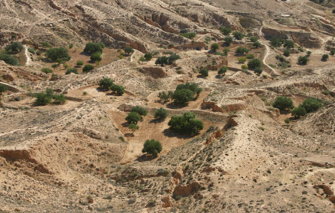
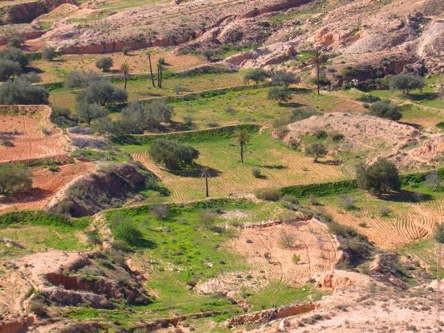
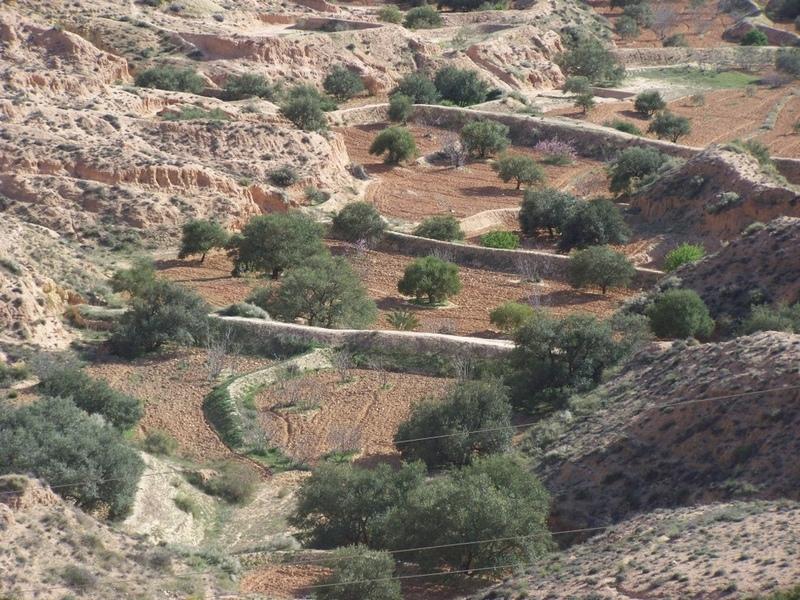
Jessour technology is generally practised in mountain dry regions (less than 200 mm annually) with medium to high slopes. This technology was behind the installation of very old olive orchards based on rainfed agriculture in rugged landscapes which allowed the local population not only to ensure self-sufficiency but also to provide neighbouring areas many agricultural produces (olive oil, dried figs, palm dates, etc.).
Jessour is the plural of jessr, which is a hydraulic unit made of three components: the impluvium, the terrace and the dyke. The impluvium or the catchment is the area which collects and conveys runoff water. It is bordered by a natural water divide line (a line that demarcates the boundary of a natural area or catchment, so that all the rain that falls on this area is concentrated and drained towards the same outlet). Each unit has its own impluvium, but can also receive excess water from upstream units. The terrace or cropping zone is the area in which farming is practised. It is formed progressively by the deposition of sediment. An artificial soil will then be created, which can be up to 5 m deep close to the dyke. Generally, fruit trees (e.g. olive, fig, almond, and date palm), legumes (e.g. pea, chickpeas, lentil, and faba bean) and barley and wheat are cultivated on these terraces.
Purpose of the Technology: Although the jessour technique was developed for the production of various agricultural crops, it now also plays three additional roles: (1) aquifer recharge, via runoff water infiltration into the terraces, (2) flood control and therefore the protection of infrastructure and towns built downstream, and (3) wind erosion control, by preventing sediment from reaching the downstream plains, where windspeeds can be particularly high.
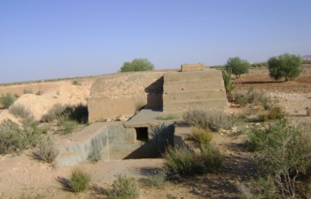
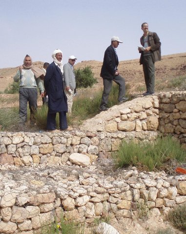
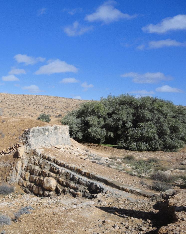
Establishment / maintenance activities and inputs: In the Jessour, a dyke (tabia, sed, katra) acts as a barrier used to hold back sediment and runoff water. Such dykes are made of earth, and are equipped with a central and/or lateral spillway (masref and/or manfes) and one or two abutments (ktef), assuring the evacuation of excess water. They are trapezoidal and measure 15-50 m in length, 1-4 m in width and 2-5 m in height. In old units, the dyke is stabilised with a covering of dry stones to overcome the erosive effects of water wave action on the front and back of the dyke. The spillway is made of stones arranged in the form of stairs, in order to dissipate the kinetic energy of the overflow.
This technology is currently encountered in the mountain ranges of Matmata of South Eastern Tunisia where the local agricultural activities are based mainly on rainfed agriculture and livestock breeding. However, high rates of migration to cities may threaten the long-term maintenance of those structures.
2.3 ຮູບພາບຂອງເຕັກໂນໂລຢີ
ສື່ຮູບພາບ

2.5 ປະເທດ / ເຂດ / ສະຖານທີ່ບ່ອນທີ່ ເຕັກໂນໂລຢີ ໄດ້ຮັບການນໍາໃຊ້ ແລະ ທີ່ຖືກປົກຄຸມດ້ວຍການປະເມີນຜົນ
ປະເທດ:
ຕູນິເຊຍ
ພາກພື້ນ / ລັດ / ແຂວງ:
Medenine
ຂໍ້ມູນເພີ່ມເຕີມຂອງສະຖານທີ່:
Beni Khedache
ໃຫ້ລະບຸ ການແຜ່ຂະຫຍາຍ ເຕັກໂນໂລຢີ:
- ແຜ່ຂະຫຍາຍຢ່າງໄວວາໃນພື້ນທີ່
ຖ້າຫາກບໍ່ຮູ້ເນື້ອທີ່ທີ່ແນ່ນອນ, ໃຫ້ລະບຸ ເນື້ອທີ່ໂດຍປະມານ ທີ່ໃກ້ຄຽງ:
- 100-1,000 ກມ 2
ຄວາມຄິດເຫັນ:
This technology is developed mainly in the upstream areas of the study watershed (mountainous zone of Béni Khédache). This system is based on runoff water harvesting for fruit trees cropping (mainly olives). The cropping areas are relatively small and rarely exceed 0.25 ha.
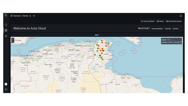
Map
×2.6 ວັນທີໃນການຈັດຕັ້ງປະຕິບັດ
ຖ້າຫາກວ່າ ບໍ່ຮູ້ຈັກ ປີທີ່ຊັດເຈນ ແມ່ນໃຫ້ປະມານ ວັນທີເອົາ:
- ຫຼາຍກ່ອນ 50 ປີຜ່ານມາ (ແບບພື້ນບ້ານ)
2.7 ການນໍາສະເໜີ ເຕັກໂນໂລຢີ
ໃຫ້ລະບຸ ເຕັກໂນໂລຢີ ໄດ້ຖືກຈັດຕັ້ງປະຕິບັດຄືແນວໃດ?
- ເປັນສ່ວນໜື່ງຂອງລະບົບພື້ນເມືອງ (>50 ປີ)
ຄວາມຄິດເຫັນ (ປະເພດ ໂຄງການ ແລະ ອື່ນໆ):
Jessour is an ancient runoff water harvesting technique widely practiced in the arid highlands, which are dominated by outcroppings of calcareous formations and depositions of quaternary calcareous silt.
3. ການໃຈ້ແຍກ ເຕັກໂນໂລຢີ ໃນການຄຸ້ມຄອງ ດິນແບບຍືນຍົງ
3.2 ປະເພດການນໍາໃຊ້ທີ່ດິນ ໃນປະຈຸບັນ() ທີ່ເຕັກໂນໂລຢີ ໄດ້ຖືກນໍາໃຊ້

ດິນທີ່ປູກພືດ
- ການປູກພືດປະຈໍາປີ
- ເປັນໄມ້ຢືນຕົ້ນ ແລະ ໄມ້ພຸ່ມ ຈາກການປູກພືດ
ການປູກພືດປະຈຳປີ - ລະບຸປະເພດພືດ:
- ທັນຍາພືດ-ພືດ ອື່ນໆ
- ທັນຍາພືດ - ເຂົ້າສາລີ
- ທັນຍາພືດ-ເຂົ້າບາເລ້
- ຜັກ-ອື່ນໆ
- ພືດຕະກູນຖົ່ວ ແລະ ຖົ່ວແປກ
ການປູກພືດທີ່ເປັນຕົ້ນໄມ້ ແລະ ໄມ້ພຸ່ມ - ລະບຸປະເພດພືດ:
- ວັນທີ
- ໝາກເດືອຍ
- ຕົ້ນຖົ່ວ ( ຖົ່ວເບຣຊິນ. ພິສຕາຄິໂອ. ວໍນັດ. ອ່າວມ້ອນ ແລະ ອື່ນໆ)
- ຕົ້ນໂອລີບ
ຈໍານວນ ລະດູການ ປູກໃນປີໜຶ່ງ:
- 1
ລະບຸ ຊະນິດ:
Longest growing period in days: 180Longest growing period from month to month: Oct - Mar
ຄວາມຄິດເຫັນ:
Major land use problems (compiler’s opinion): Loss of surface water (runoff), problems of flooding, water erosion, soil degradation, drought
Future (final) land use (after implementation of SLM Technology): Cropland: Ct: Tree and shrub cropping
Livestock is grazing on crop residues
3.3 ການນຳໃຊ້ທີ່ດິນ ມີການປ່ຽນແປງຍ້ອນການຈັດຕັ້ງທົດລອງເຕັກໂນໂລຢີ ແມ່ນບໍ່?
ການນຳໃຊ້ທີ່ດິນ ມີການປ່ຽນແປງຍ້ອນການຈັດຕັ້ງທົດລອງເຕັກໂນໂລຢີ ແມ່ນບໍ່?
- ແມ່ນ (ກະລຸນາຕື່ມໃສ່ ຄຳຖາມຂ້າງລຸ່ມນີ້ກ່ຽວກັບການນຳໃຊ້ທີ່ດິນ ກ່ອນການທົດລອງເຕັກໂນໂລຢີ)
ການນຳໃຊ້ທີ່ດິນ ປະສົມພາຍໃນພື້ນທີ່ດຽວກັນ:
ແມ່ນ
ລະບຸການນຳໃຊ້ທີ່ດິນແບບປະສົມ (ຜົນລະປູກ / ທົ່ງຫຍ້າລ້ຽງສັດ / ຕົ້ນໄມ້):
- ກະສິກໍາແບບປະສົມປະສານ (ລວມທັງ ການລ້ຽງສັດ-ປຸກຝັງ)
ດິນທີ່ປູກພືດ
- ເປັນໄມ້ຢືນຕົ້ນ ແລະ ໄມ້ພຸ່ມ ຈາກການປູກພືດ

ທົ່ງຫຍ້າລ້ຽງສັດ
3.4 ການສະໜອງນ້ຳ
ການສະໜອງນໍ້າ ໃນພື້ນທີ່ ທີ່ໄດ້ນໍາໃຊ້ ເຕັກໂນໂລຢີ:
- ນໍ້າຝົນ
ຄວາມຄິດເຫັນ:
Water supply: rainfed, mixed rainfed - irrigated
3.5 ການນໍາໃຊ້ເຕັກໂນໂລຢີ ທີ່ຢູ່ໃນກຸ່ມການຄຸ້ມຄອງ ທີ່ດິນແບບຍືນຍົງ
- ແລວກັນລົມ / ພາຍຸ
- ການເກັບກັກນໍ້າ
- ການຄຸ້ມຄອງຊົນລະປະທານ (ການສະໜອງນໍ້າ, ລະບາຍ)
3.6 ມາດຕະການ ການຄຸ້ມຄອງ ທີ່ດິນແບບຍືນຍົງ ປະກອບດ້ວຍ ເຕັກໂນໂລຢີ

ມາດຕະການໂຄງສ້າງ
- S2: ຄັນຄຸ, ແຄມຕາຝັ່ງ
ຄວາມຄິດເຫັນ:
Main measures: structural measures
3.7 ປະເພດດິນເຊື່ອມໂຊມ ຫຼັກທີ່ໄດ້ນໍາໃຊ້ ເຕັກໂນໂລຢີ

ດິນເຊາະເຈື່ອນ ໂດຍນໍ້າ
- Wt: ການສູນເສຍຊັ້ນໜ້າດິນ / ການເຊາະເຈື່ອນຜິວໜ້າດິນ
- Wg: ການເຊາະເຈື່ອນຮ່ອງນ້ຳ / ຫ້ວຍ
ຄວາມຄິດເຫັນ:
Main type of degradation addressed: Wt: loss of topsoil / surface erosion
Secondary types of degradation addressed: Wg: gully erosion / gullying
Main causes of degradation: crop management (annual, perennial, tree/shrub), change of seasonal rainfall, Heavy / extreme rainfall (intensity/amounts), poverty / wealth
Secondary causes of degradation: soil management, overgrazing, land tenure
3.8 ການປ້ອງກັນ, ການຫຼຸດຜ່ອນ, ຫຼືການຟື້ນຟູຂອງການເຊື່ອມໂຊມຂອງດິນ
ໃຫ້ລະບຸ ເປົ້າໝາຍ ເຕັກໂນໂລຢີ ທີ່ພົວພັນ ກັບຄວາມເຊື່ອມໂຊມຂອງດິນ:
- ປ້ອງກັນການເຊື່ອມໂຊມຂອງດິນ
- ຫຼຸດຜ່ອນການເຊື່ອມໂຊມຂອງດິນ
ຄວາມຄິດເຫັນ:
Main goals: mitigation / reduction of land degradation
Secondary goals: prevention of land degradation
4. ຂໍ້ກໍາໜົດ, ກິດຈະກໍາການປະຕິບັດ, ວັດຖຸດິບ, ແລະຄ່າໃຊ້ຈ່າຍ
4.1 ເຕັກນິກ ໃນການແຕ້ມແຜນວາດ ເຕັກໂນໂລຢີ
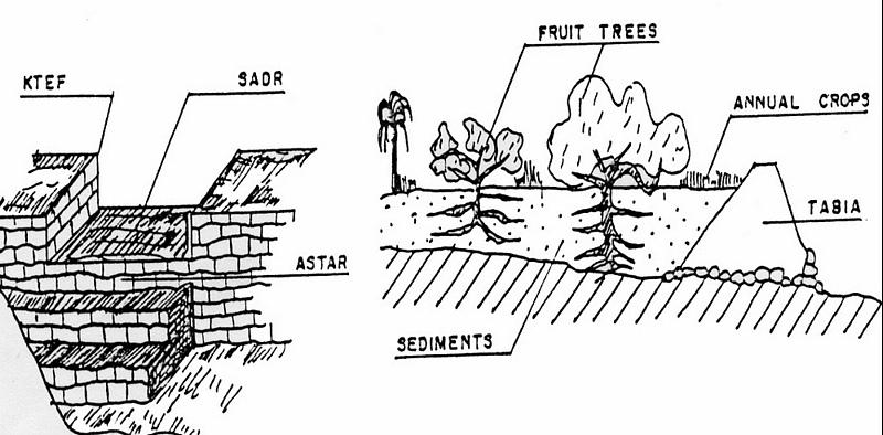
ຄຸນລັກສະນະ ຂອງເຕັກນິກ (ທີ່ກ່ຽວຂ້ອງ ກັບການແຕ້ມແຜນວາດ ທາງດ້ານເຕັກນີກ):
Left: Cross-section of dyke (locally called tabia) and terrace (cropping area).
The Jessour ensure the collection of both runoff water and sediments allowing creating very deep ‘artificial’ soils (terrace) which form a very good reservoir for water and nutrients to be used by fruit trees and annual crops.
Right: The spillway allows the overflow to the other Jessour downstream. It also represents the symbol of water sharing equity between different farmers in the same watershed. (Drawing adapted from El Amami (1984))
Location: Mountainous zone near Beni Khedache. Medenine
Date: 1984
Technical knowledge required for field staff / advisors: moderate
Technical knowledge required for land users: moderate
Main technical functions: increase of infiltration, sediment retention / trapping, sediment harvesting, harvesting of runoff water / water trapping
Secondary technical functions: control of concentrated runoff: retain / trap, improvement of ground cover, increase / maintain water stored in soil, increase of groundwater level / recharge of groundwater, increase of biomass (quantity)
Spillway
Height of bunds/banks/others (m): 2-5
Width of bunds/banks/others (m): 0.4-0.6
Length of bunds/banks/others (m): 2-6
Dam/ pan/ pond
Vertical interval between structures (m): 2-3
Spacing between structures (m): 30-70
Height of bunds/banks/others (m): 2-6
Width of bunds/banks/others (m): 1-5
Length of bunds/banks/others (m): 10-40
Construction material (earth): Main dyke
Construction material (stone): Spillway and in some cases the dyke (external coating)
Construction material (concrete): Occasionally for consolidation of the spillway.
Lateral gradient along the structure: <1%
Specification of dams/ pans/ ponds: Capacity 300-1000m3
Catchment area: 1-10ham2
Beneficial area: 0.01-1ham2
For water harvesting: the ratio between the area where the harvested water is applied and the total area from which water is collected is: 1:5
ຜູ້ຂຽນ:
Ouessar M., IRA, Medenine, Tunisia
4.2 ຂໍ້ມູນທົ່ວໄປກ່ຽວກັບການຄິດໄລ່ປັດໃຈຂາເຂົ້າໃນການຜະລິດ ແລະ ມູນຄ່າອື່ນໆ
ສະກຸນເງິນອື່ນໆ / ປະເທດອື່ນໆ (ລະບຸ):
TD
ຖ້າກ່ຽວຂ້ອງ, ໃຫ້ລະບຸອັດຕາແລກປ່ຽນຈາກ USD ເປັນສະກຸນເງິນທ້ອງຖິ່ນ (ເຊັ່ນ: 1 USD = 79.9 Brazilian Real): 1 USD =:
1.3
ລະບຸ ຄ່າຈ້າງ ຄ່າແຮງງານສະເລ່ຍ ຕໍ່ ວັນ:
10.00
4.3 ການສ້າງຕັ້ງກິດຈະກໍາ
| ກິດຈະກໍາ | Timing (season) | |
|---|---|---|
| 1. | Dyke construction | |
| 2. | Plantations | |
| 3. | Spillway construction |
4.4 ຕົ້ນທຶນ ແລະ ປັດໄຈຂາເຂົ້າທີ່ຈໍາເປັນໃນຈັດຕັ້ງປະຕິບັດ
| ລະບຸ ປັດໃຈ ນໍາເຂົ້າ ໃນການຜະລີດ | ຫົວໜ່ວຍ | ປະລິມານ | ຕົ້ນທຶນ ຕໍ່ຫົວໜ່ວຍ | ຕົ້ນທຶນທັງໝົດ ຂອງປັດໃຈຂາເຂົ້າ ໃນການຜະລິດ | % ຂອງຕົ້ນທຶນທັງໝົດ ທີ່ຜູ້ນໍາໃຊ້ທີ່ດິນ ໃຊ້ຈ່າຍເອງ | |
|---|---|---|---|---|---|---|
| ແຮງງານ | Labour | ha | 1.0 | 1200.0 | 1200.0 | 100.0 |
| ວັດສະດຸໃນການປູກ | ha | 1.0 | 800.0 | 800.0 | 100.0 | |
| ວັດສະດຸກໍ່ສ້າງ | ha | 1.0 | 1000.0 | 1000.0 | 100.0 | |
| ຕົ້ນທຶນທັງໝົດ ໃນການຈັດຕັ້ງປະຕິບັດ ເຕັກໂນໂລຢີ | 3000.0 | |||||
| ຄ່າໃຊ້ຈ່າຍທັງໝົດ ສຳລັບການສ້າງຕັ້ງເຕັກໂນໂລຢີ ເປັນສະກຸນເງີນໂດລາ | 2307.69 | |||||
ຄວາມຄິດເຫັນ:
Duration of establishment phase: 6 month(s)
4.5 ບໍາລຸງຮັກສາ / ແຜນຈັດຕັ້ງປະຕິບັດ ກິດຈະກໍາ
| ກິດຈະກໍາ | ໄລຍະເວລາ / ຄວາມຖີ່ | |
|---|---|---|
| 1. | Crop and trees maintenance | Annually |
| 2. | Dyke and spillway maintenance | |
| 3. | Repairs | |
| 4. | Tillage (against soil sealing) | |
| 5. | Tillage (against soil sealing) | Annually and after rainy events |
4.6 ຄ່າໃຊ້ຈ່າຍ ແລະ ປັດໄຈນໍາເຂົ້າທີ່ຈໍາເປັນສໍາລັບການບໍາລຸງຮັກສາກິດຈະກໍາ / ແຜນປະຕິບັດ (ຕໍ່ປີ)
| ລະບຸ ປັດໃຈ ນໍາເຂົ້າ ໃນການຜະລີດ | ຫົວໜ່ວຍ | ປະລິມານ | ຕົ້ນທຶນ ຕໍ່ຫົວໜ່ວຍ | ຕົ້ນທຶນທັງໝົດ ຂອງປັດໃຈຂາເຂົ້າ ໃນການຜະລິດ | % ຂອງຕົ້ນທຶນທັງໝົດ ທີ່ຜູ້ນໍາໃຊ້ທີ່ດິນ ໃຊ້ຈ່າຍເອງ | |
|---|---|---|---|---|---|---|
| ແຮງງານ | Labour | ha | 1.0 | 400.0 | 400.0 | 100.0 |
| ວັດສະດຸໃນການປູກ | ha | 1.0 | 200.0 | 200.0 | 100.0 | |
| ວັດສະດຸກໍ່ສ້າງ | ha | 1.0 | 300.0 | 300.0 | 100.0 | |
| ຕົ້ນທຶນທັງໝົດ ທີ່ໃຊ້ໃນການບໍາລຸງຮັກສາ ເຕັກໂນໂລຢີ | 900.0 | |||||
| ຄ່າໃຊ້ຈ່າຍທັງໝົດ ສຳລັບການບົວລະບັດຮກສາເຕັກໂນໂລຢີ ເປັນສະກຸນເງີນໂດລາ | 692.31 | |||||
ຄວາມຄິດເຫັນ:
Machinery/ tools: Tractor, animals and manual works.
The technology establishment and maintenance costs met by the land users are 100% if executed on a private basis, but it can range from 10 to 50% when the site is subject to a publicly-funded programme.
4.7 ປັດໄຈ ທີ່ສໍາຄັນ ທີ່ສົ່ງຜົນກະທົບ ຕໍ່ຄ່າໃຊ້ຈ່າຍ
ໃຫ້ອະທິບາຍ ປັດໃຈ ທີ່ສົ່ງຜົນກະທົບ ຕໍ່ຕົ້ນທຶນ ໃນການຈັດຕັ້ງປະຕິບັດ:
Found in inaccessible and even remote areas, labour is the most determining factors affecting the costs of this system.
5. ສະພາບແວດລ້ອມທໍາມະຊາດ ແລະ ມະນຸດ
5.1 ອາກາດ
ປະລິມານນໍ້າຝົນປະຈໍາປີ
- < 250 ມີລິແມັດ
- 251-500 ມີລິແມັດ
- 501-750 ມີລິແມັດ
- 751-1,000 ມີລິແມັດ
- 1,001-1,500 ມີລິແມັດ
- 1,501-2,000 ມີລິແມັດ
- 2,001-3,000 ມີລິແມັດ
- 3,001-4,000 ມີລິແມັດ
- > 4,000 ມີລິແມັດ
ເຂດສະພາບອາກາດກະສິກໍາ
- ແຫ້ງແລ້ງ
Thermal climate class: subtropics
5.2 ພູມິປະເທດ
ຄ່າສະເລ່ຍ ຄວາມຄ້ອຍຊັນ:
- ພື້ນທີ່ຮາບພຽງ (0-2%)
- ອ່ອນ (3-5 %)
- ປານກາງ (6-10 %)
- ມ້ວນ (11-15 %)
- ເນີນ(16-30%)
- ໍຊັນ (31-60%)
- ຊັນຫຼາຍ (>60%)
ຮູບແບບຂອງດິນ:
- ພູພຽງ / ທົ່ງພຽງ
- ສັນພູ
- ເປີ້ນພູ
- ເນີນພູ
- ຕີນພູ
- ຮ່ອມພູ
ເຂດລະດັບສູງ:
- 0-100 ແມັດ a.s.l.
- 101-500 ແມັດ a.s.l.
- 501-1,000 ແມັດ a.s.l.
- 1,001-1,500 ແມັດ a.s.l.
- 1,501-2,000 ແມັດ a.s.l.
- 2,001-2,500 ແມັດ a.s.l.
- 2,501-3,000 ແມັດ a.s.l.
- 3,001-4,000 ແມັດ a.s.l.
- > 4,000 ແມັດ a.s.l.
ຄຳເຫັນ ແລະ ຂໍ້ມູນສະເພາະ ເພີ່ມເຕີມ ກ່ຽວກັບ ພູມີປະເທດ:
Altitudinal zone: 101-500 m a.s.l. (This is the most appropriate location)
Landforms: Mountain slopes (This is the most appropriate location)
5.3 ດິນ
ຄວາມເລິກ ຂອງດິນສະເລ່ຍ:
- ຕື້ນຫຼາຍ (0-20 ຊັງຕີແມັດ)
- ຕື້ນ (21-50 ຊຕມ)
- ເລີກປານກາງ (51-80 ຊຕມ)
- ເລິກ (81-120 ຊມ)
- ເລິກຫຼາຍ (> 120 cm)
ເນື້ອດິນ (ໜ້າດິນ):
- ຫຍາບ / ເບົາ (ດິນຊາຍ)
- ປານກາງ (ດິນໜຽວ, ດິນໂຄນ)
ຊັ້ນອິນຊີວັດຖຸ ເທິງໜ້າດິນ:
- ຕໍາ່ (<1 %)
ຖ້າເປັນໄປໄດ້ ແມ່ນໃຫ້ຕິດຄັດ ການພັນລະນາດິນ ຫຼື ຂໍ້ມູນສະເພາະຂອງດິນ, ຕົວຢ່າງ, ຄຸນລັກສະນະ ປະເພດຂອງດິນ, ຄ່າຄວາມເປັນກົດ / ເປັນດ່າງຂອງດິນ, ສານອາຫານ, ດິນເຄັມ ແລະ ອື່ນໆ.
Soil depth: Very shallow-shallow. Very deep in particular case of loess deposits.
Soil fertility is: Very low
Soil drainage/infiltration is: Medium
Soil water storage: Medium
5.4 ມີນໍ້າ ແລະ ຄຸນນະພາບ
ລະດັບ ນໍ້າໃຕ້ດິນ:
5-50 ແມັດ
ການມີນໍ້າ ເທິງໜ້າດິນ:
ປານກາງ
ຄຸນນະພາບນໍ້າ (ບໍ່ມີການບໍາບັດ):
ບໍ່ມີນໍ້າດື່ມ (ຮຽກຮ້ອງໃຫ້ມີການບຳບັດນ້ຳ)
ຄວາມຄິດເຫັນ ແລະ ຂໍ້ກໍານົດ ເພີ່ມເຕີມ ກ່ຽວກັບ ຄຸນນະພາບ ແລະ ປະລິມານ ຂອງນ້ຳ:
Water quality untreated: Poor drinking water (treatement required) (ground water better than surface water (cisterns))
5.5 ຊີວະນາໆພັນ
ຄວາມຫຼາກຫຼາຍ ທາງສາຍພັນ:
- ປານກາງ
5.6 ຄຸນລັກສະນະ ຂອງຜູ້ນໍາໃຊ້ທີ່ດິນ ທີ່ໄດ້ນໍາໃຊ້ເຕັກໂນໂລຢີ
ລະບົບ ການຕະຫຼາດ ແລະ ຜົນຜະລິດ:
- ກຸ້ມຕົນເອງ (ພໍພຽງ)
- ປະສົມປົນເປ( ກຸ້ມຕົນເອງ/ເປັນສິນຄ້າ)
ລາຍຮັບ ທີ່ບໍ່ໄດ້ມາຈາກ ການຜະລິດ ກະສິກໍາ:
- > 50 % ຂອງລາຍຮັບທັງໝົດ
ລະດັບຄວາມຮັ່ງມີ:
- ທຸກຍາກ
- ສະເລ່ຍ
ບຸກຄົນ ຫຼື ກຸ່ມ:
- ບຸກຄົນ / ຄົວເຮືອນ
ລະດັບ ການຫັນເປັນກົນຈັກ:
- ການໃຊ້ແຮງງານຄົນ
- ສັດລາກແກ່
ເພດ:
- ຜູ້ຊາຍ
ໃຫ້ລະບຸ ຄຸນລັກສະນະ ຂອງຜູ້ນໍາໃຊ້ທີ່ດິນ:
Land users applying the Technology are mainly common / average land users
Difference in the involvement of women and men: Historically, the hard work is done by men.
Population density: 10-50 persons/km2
Annual population growth: < 0.5%
10% of the land users are rich and own 20% of the land.
80% of the land users are average wealthy and own 75% of the land.
10% of the land users are poor and own 5% of the land.
Off-farm income specification: The technique is very ancient and, therefore, ALL the farmers apply this technology. The only difference is the number of the owned units.
Off-farm incomes come from migration, construction works, commerce, tourism sector, administration or informal activities.
Level of mechanization: Manual work and animal traction (Especially in remote areas with difficult access)
5.7 ເນື້ອທີ່ສະເລ່ຍຂອງດິນ ທີ່ຜູ້ນຳໃຊ້ທີ່ດິນ ໃຊ້ເຮັດເຕັກໂນໂລຢີ
- <0.5 ເຮັກຕາ
- 0.5-1 ເຮັກຕາ
- 1-2 ເຮັກຕາ
- 2-5 ເຮັກຕາ
- 5-15 ເຮັກຕາ
- 15-50 ເຮັກຕາ
- 50-100 ເຮັກຕາ
- 100-500 ເຮັກຕາ
- 500-1,000 ເຮັກຕາ
- 1,000-10,000 ເຮັກຕາ
- > 10,000 ເຮັກຕາ
ຖືໄດ້ວ່າ ເປັນຂະໜາດນ້ອຍ, ກາງ ຫຼື ໃຫຍ່ (ອີງຕາມເງື່ອນໄຂ ສະພາບຄວາມເປັນຈິງ ຂອງທ້ອງຖີ່ນ)? :
- ຂະໜາດນ້ອຍ
5.8 ເຈົ້າຂອງທີ່ດິນ, ສິດໃຊ້ທີ່ດິນ, ແລະ ສິດທິການນໍາໃຊ້ນໍ້າ
ເຈົ້າຂອງດິນ:
- ບຸກຄົນ, ບໍ່ມີຕໍາແໜ່ງ
ສິດທິ ໃນການນໍາໃຊ້ທີ່ດິນ:
- ບຸກຄົນ
ສິດທິ ໃນການນໍາໃຊ້ນໍ້າ:
- ບຸກຄົນ
ຄວາມຄິດເຫັນ:
The communal rule applies in this region: the farmer owns the terrace (the cropping area) and its impluvium from which the runoff is harvested.
5.9 ການເຂົ້າເຖິງການບໍລິການ ແລະ ພື້ນຖານໂຄງລ່າງ
ສຸຂະພາບ:
- ທຸກຍາກ
- ປານກາງ
- ດີ
ການສຶກສາ:
- ທຸກຍາກ
- ປານກາງ
- ດີ
ການຊ່ວຍເຫຼືອ ດ້ານວິຊາການ:
- ທຸກຍາກ
- ປານກາງ
- ດີ
ການຈ້າງງານ (ຕົວຢ່າງ, ການເຮັດກິດຈະກໍາອື່ນ ທີ່ບໍ່ແມ່ນ ການຜະລິດກະສິກໍາ):
- ທຸກຍາກ
- ປານກາງ
- ດີ
ຕະຫຼາດ:
- ທຸກຍາກ
- ປານກາງ
- ດີ
ພະລັງງານ:
- ທຸກຍາກ
- ປານກາງ
- ດີ
ຖະໜົນຫົນທາງ ແລະ ການຂົນສົ່ງ:
- ທຸກຍາກ
- ປານກາງ
- ດີ
ການດື່ມນໍ້າ ແລະ ສຸຂາພິບານ:
- ທຸກຍາກ
- ປານກາງ
- ດີ
ການບໍລິການ ທາງດ້ານການເງິນ:
- ທຸກຍາກ
- ປານກາງ
- ດີ
6. ຜົນກະທົບ ແລະ ລາຍງານສະຫຼຸບ
6.1 ການສະແດງຜົນກະທົບ ພາຍໃນພື້ນທີ່ ທີ່ໄດ້ຈັດຕັ້ງປະຕິບັດ ເຕັກໂນໂລຢີ
ຜົນກະທົບທາງເສດຖະກິດສັງຄົມ
ການຜະລິດ
ການຜະລິດພືດ
ຄວາມສ່ຽງ ຕໍ່ຜົນຜະລິດ
ຄວາມໜາແໜ້ນ ຂອງຜົນຜະລິດ
ເນື້ອທີ່ການຜະລິດ
ຄວາມຄິດເຫັນ / ລະບຸແຈ້ງ:
Reduced grazing lands
ລາຍໄດ້ ແລະ ຄ່າໃຊ້ຈ່າຍ
ລາຍຮັບ ຈາກການຜະລີດ
ຄວາມຫຼາກຫຼາຍ ຂອງແຫຼ່ງລາຍຮັບ
ຜົນກະທົບດ້ານວັດທະນາທໍາສັງຄົມ
ການຄໍ້າປະກັນ ສະບຽງອາຫານ / ກຸ້ມຢູ່ກຸ້ມກິນ
ຄວາມຮູ້ກ່ຽວກັບ ການຄຸ້ມຄອງ ທີ່ດິນແບບຍືນຍົງ / ການເຊື່ອມໂຊມຂອງດິນ
ການຫຼຸດຜ່ອນ ຂໍ້ຂັດແຍ່ງ
ສະຖານະການຂອງສັງຄົມ ແລະ ກຸ່ມດ້ອຍໂອກາດທາງເສດຖະກິດ
ຜົນກະທົບຕໍ່ລະບົບນິເວດ
ວົງຈອນນໍ້າ / ນໍ້າ
ການຂຸດຄົ້ນ / ການເກັບກັກນໍ້າ
ການໄຫຼ ຂອງນໍ້າໜ້າດິນ
ຊັ້ນນໍ້າໄຕ້ດິນ / ນໍ້າ
ດິນ
ການສູນເສຍດິນ
6.2 ຜົນກະທົບທາງອ້ອມ ຈາກການນໍາໃຊ້ເຕັກໂນໂລຢີ
ສາມາດເຂົ້າເຖິງແຫຼ່ງນໍ້າ
ການໄຫຼຂອງນໍ້າໃນລະດູແລ້ງ
ນໍ້າຖ້ວມຢູ່ເຂດລຸ່ມນໍ້າ
ການທັບຖົມ ຂອງດິນຕະກອນ ຢູ່ເຂດລຸ່ມນໍ້າ
ຄວາມເສຍຫາຍ ກ່ຽວກັບພື້ນຖານໂຄງລ່າງ ສາທາລະນະ / ເອກກະຊົນ
Runoff
ຄວາມຄິດເຫັນ / ລະບຸແຈ້ງ:
Reduced available runoff for downstream users
6.3 ການປ້ອງກັນ ແລະ ຄວາມບອບບາງ ຂອງເຕັກໂນໂລຢິ ໃນການປ່ຽນແປງສະພາບດິນຟ້າອາກາດ ແລະ ກ່ຽວຂ້ອງກັບອາກາດທີ່ມີການປ່ຽນແປງທີ່ຮຸນແຮງ / ໄພພິບັດທາງທໍາມະຊາດ (ຮັບຮູ້ໄດ້ໂດຍຜູ້ນໍາໃຊ້ທີ່ດິນ)
ການປ່ຽນແປງດິນຟ້າອາກາດ ເທື່ອລະກ້າວ
ການປ່ຽນແປງດິນຟ້າອາກາດ ເທື່ອລະກ້າວ
| ລະດູການ | ເພີ່ມຂື້ນ ຫຼື ຫຼຸດລົງ | ການນໍາໃຊ້ ເຕັກໂນໂລຢີ ສາມາດ ຮັບມື ໄດ້ຄືແນວໃດ? | |
|---|---|---|---|
| ອຸນຫະພູມປະຈໍາປີ | ເພີ່ມຂື້ນ | ດີ |
ອາກາດ ທີ່ກ່ຽວພັນກັບຄວາມຮຸນແຮງ (ໄພພິບັດທາງທໍາມະຊາດ)
ໄພພິບັດທາງອຸຕຸນິຍົມ
| ການນໍາໃຊ້ ເຕັກໂນໂລຢີ ສາມາດ ຮັບມື ໄດ້ຄືແນວໃດ? | |
|---|---|
| ພະຍຸຝົນ | ດີ |
| ພາຍຸລົມທ້ອງຖິ່ນ | ດີ |
ໄພພິບັດທາງພູມອາກາດ
| ການນໍາໃຊ້ ເຕັກໂນໂລຢີ ສາມາດ ຮັບມື ໄດ້ຄືແນວໃດ? | |
|---|---|
| ແຫ້ງແລ້ງ | ດີ |
ໄພພິບັດທາງອຸທົກກະສາກ
| ການນໍາໃຊ້ ເຕັກໂນໂລຢີ ສາມາດ ຮັບມື ໄດ້ຄືແນວໃດ? | |
|---|---|
| ໂດຍທົ່ວໄປ (ແມ່ນໍ້າ) ນໍ້າຖ້ວມ | ບໍ່ດີ |
ຜົນສະທ້ອນສະພາບອາກາດອື່ນໆທີ່ກ່ຽວຂ້ອງ
ຜົນສະທ້ອນສະພາບອາກາດອື່ນໆທີ່ກ່ຽວຂ້ອງ
| ການນໍາໃຊ້ ເຕັກໂນໂລຢີ ສາມາດ ຮັບມື ໄດ້ຄືແນວໃດ? | |
|---|---|
| ໄລຍະເວລາການຂະຫຍາຍຕົວຫຼຸດລົງ | ດີ |
6.4 ການວິເຄາະຕົ້ນທຶນ ແລະ ຜົນປະໂຫຍດ
ຈະເຮັດປະໂຫຍດເພື່ອປຽບທຽບກັບຄ່າໃຊ້ຈ່າຍກັບສິ່ງກໍ່ສ້າງ (ຈາກທັດສະນະຂອງຜູ້ນຳໃຊ້ທີ່ດິນ) ໄດ້ແນວໃດ?
ຜົນຕອບແທນ ໃນໄລຍະສັ້ນ:
ຜົນກະທົບທາງລົບຫຼາຍ
ຜົນຕອບແທນ ໃນໄລຍະຍາວ:
ຜົນກະທົບທາງບວກຫຼາຍ
ຈະໄດ້ຮັບຜົນປະໂຫຍດເມື່ອປຽບທຽບກັບ / ຄ່າໃຊ້ຈ່າຍໃນການບຳລຸງຮັກສາທີເ່ກີດຂື້ນອິກ (ຈາກທັດສະນະຄະຕິຂອງຜູ້ນຳໃຊ້ທີ່ດິນ) ໄດ້ແນວໃດ?
ຜົນຕອບແທນ ໃນໄລຍະສັ້ນ:
ປານກາງ
ຜົນຕອບແທນ ໃນໄລຍະຍາວ:
ຜົນກະທົບທາງບວກ
6.5 ການປັບຕົວຮັບເອົາເຕັກໂນໂລຢີ
ທັງໝົດນັ້ນ ແມ່ນໃຜ ໄດ້ປັບຕົວເຂົ້າ ໃນການນໍາໃຊ້ ເຕັກໂນໂລຢີ, ມີຈັກຄົນ ທີ່ສາມາດເຮັດເອງໄດ້, ຕົວຢ່າງ, ປາດສະຈາກ ການຊ່ວຍເຫຼືອ ທາງດ້ານອຸປະກອນ / ການຈ່າຍເປັນເງິນ?
- 91-100%
ຄວາມຄິດເຫັນ:
10% of land user families have adopted the Technology with external material support
90% of land user families have adopted the Technology without any external material support
Comments on spontaneous adoption: This technique is very ancient and it is therefore already fully adopted/used in the region.
There is a moderate trend towards spontaneous adoption of the Technology
6.7 ຈຸດແຂງ / ຂໍ້ດີ / ໂອກາດ ໃນການນໍາໃຊ້ ເຕັກໂນໂລຢີ
| ຈຸດແຂງ / ຂໍ້ດີ / ໂອກາດໃນການນໍາໃຊ້ທີ່ດິນ |
|---|
|
Well known technique by the local population How can they be sustained / enhanced? training of new generations |
| ຈຸດແຂງ / ຈຸດດີ / ໂອກາດ ຈາກທັດສະນະຂອງຜູ້ປ້ອນຂໍ້ມູນ ຫຼື ບຸກຄົນສຳຄັນ |
|---|
|
This technique allowed a expansion of cropping lands in the mountain area How can they be sustained / enhanced? encourage maintenance of existing structure |
|
Allows crop production in very dry environments (with less than 200 mm of rainfall) How can they be sustained / enhanced? encourage maintenance of existing structure |
|
Collects and accumulates water, soil and nutrients behind the tabia and makes it available to crops How can they be sustained / enhanced? encourage maintenance of existing structure |
|
Reduced damage by flooding How can they be sustained / enhanced? encourage maintenance of existing structure |
|
Well adapted technology for the ecological environment How can they be sustained / enhanced? ensure maintenance works |
6.8 ຈຸດອ່ອນ / ຂໍ້ເສຍ / ຄວາມສ່ຽງ ໃນການນໍາໃຊ້ ເຕັກໂນໂລຢີ ແລະ ວິທີການແກ້ໄຂບັນຫາ
| ຈຸດອ່ອນ / ຂໍ້ເສຍ / ຄວາມສ່ຽງໃນມຸມມອງຂອງຜູ້ນໍາໃຊ້ທີ່ດິນ | ມີວິທີການແກ້ໄຂຄືແນວໃດ? |
|---|---|
| Productivity of the land is very low | Development of alternative income generation activities. |
| Land ownership fragmentation | New land access |
| ຈຸດອ່ອນ/ຂໍ້ບົກຜ່ອງ/ຄວາມສ່ຽງ ຈາກທັດສະນະຂອງຜູ້ປ້ອນຂໍ້ມູນ ຫຼື ບຸກຄົນສຳຄັນ | ມີວິທີການແກ້ໄຂຄືແນວໃດ? |
|---|---|
| Risks related to the climatic changes | It needs to be combined with supplemental irrigation |
| Risk of local know how disappearence | Trainig of new generations |
| Land ownership fragmentation | Agrarian reform |
7. ເອກະສານອ້າງອີງ ແລະ ການເຊື່ອມຕໍ່
7.1 ວິທີການ / ແຫຼ່ງຂໍ້ມູນ
7.2 ເອກກະສານອ້າງອີງທີ່ເປັນບົດລາຍງານ
ຫົວຂໍ້, ຜູ້ຂຽນ, ປີ, ISBN:
El Amami, S. 1984. Les aménagements hydrauliques traditionnels en Tunisie. Centre de Recherche en Génie Rural (CRGR), Tunis, Tunisia. 69 pp.
ມີຢູ່ໃສ?ມູນຄ່າເທົ່າໃດ?
ENGREF - Tunis
ຫົວຂໍ້, ຜູ້ຂຽນ, ປີ, ISBN:
Ennabli, N. 1993. Les aménagements hydrauliques et hydro-agricoles en Tunisie. Imprimerie Officielle de la République Tunisienne, Tunis, 255 pp.
ມີຢູ່ໃສ?ມູນຄ່າເທົ່າໃດ?
INAT - Tunis
ຫົວຂໍ້, ຜູ້ຂຽນ, ປີ, ISBN:
Ben Mechlia, N., Ouessar, M. 2004. Water harvesting systems in Tunisia. In: Oweis, T., Hachum, A., Bruggeman, A. (eds). Indigenous water harvesting in West Asia and North Africa, , ICARDA, Aleppo, Syria, pp: 21-41.
ມີຢູ່ໃສ?ມູນຄ່າເທົ່າໃດ?
ICARDA
ຫົວຂໍ້, ຜູ້ຂຽນ, ປີ, ISBN:
Genin, D., Guillaume, H., Ouessar, M., Ouled Belgacem, A., Romagny, B., Sghaier, M., Taamallah, H. (eds) 2006. Entre la désertification et le développement : la Jeffara tunisienne. CERES, Tunis, 351 pp.
ມີຢູ່ໃສ?ມູນຄ່າເທົ່າໃດ?
IRA; IRD
ຫົວຂໍ້, ຜູ້ຂຽນ, ປີ, ISBN:
Ouessar M. 2007. Hydrological impacts of rainwater harvesting in wadi Oum Zessar watershed (Southern Tunisia). Ph.D. thesis, Faculty of Bioscience Engineering, Ghent University, Ghent, Belgium, 154 pp.
ມີຢູ່ໃສ?ມູນຄ່າເທົ່າໃດ?
IRA
ຫົວຂໍ້, ຜູ້ຂຽນ, ປີ, ISBN:
Sghaier, M., Mahdhi, N., De Graaff, J., Ouessar, M. 2002. Economic assessment of soil and water conservation works: case of the wadi Oum Zessar watershed in south-eastern Tunisia.TRMP paper n° 40, Wageningen University, The Netherlands, pp: 101-113.
ມີຢູ່ໃສ?ມູນຄ່າເທົ່າໃດ?
IRA
ຂໍ້ມູນການເຊື່ອມຕໍ່ ແລະ ເນື້ອໃນ
ຂະຫຍາຍທັງໝົດ ຍຸບທັງໝົດການເຊື່ອມຕໍ່
Observatoire Territorial de Gestion des Ressources Naturelles [ຕູນິເຊຍ]
L’observatoire territorial de gestion des ressources naturelles est un dispositif scientifique, technique et institutionnel mis en place sur un territoire, pour assurer une fonction d’observation, de suivi, et d’amélioration de la connaissance.
- ຜູ້ສັງລວມຂໍ້ມູນ: Wafa Saidi
Projet d'Aménagement et de Développement Intégré du Territoire … [ຕູນິເຊຍ]
Le Projet d'Aménagement et de Développement Intégré du Territoire (PADIT) est basé sur la sollicitation des populations locales et la collaboration avec tous les acteurs impliqués dans la gestion des ressources naturelles et du développement rural afin de valoriser les atouts d'un territoire donné et élaborer un plan d'action intégré …
- ຜູ້ສັງລວມຂໍ້ມູນ: Wafa Saidi
Collecte des eaux pluviales dans des citernes [ຕູນິເຊຍ]
Les citernes sont construites soit par l’état dans les zones enclavées où l’approvisionnement en eaux potables et difficile voire impossible par le réseau de la Société Nationale d’Exploitation et de Distribution des Eaux (SONEDE) soit par des particuliers pour collecter les eaux de pluies. Ces ouvrages sont destinés à l’abreuvement …
- ຜູ້ສັງລວມຂໍ້ມູນ: Donia Mühlematter
Conservation des eaux et des sols suivant la … [ຕູນິເຊຍ]
Les « jessour » sont développés dans les zones montagneuses de Gabès, Mede-nine et Tataouine où l’altitude varie entre 400 et 600 m et une pluviométrie an-nuelle variant entre 100 et 150 mm. Dans cette zone, on compte aux alentours de 35 000 jisr qui reçoit chacun annuellement un supplément …
- ຜູ້ສັງລວມຂໍ້ມູນ: Donia Mühlematter
Dryland watershed management approach [ຕູນິເຊຍ]
Integrated land and water management approach, including vegetative, management, and agronomic measure
- ຜູ້ສັງລວມຂໍ້ມູນ: Naceur Mahdi
ເນື້ອໃນ
ບໍ່ມີເນື້ອໃນ