Planting pits and stone lines [ໄນເຈີ]
- ການສ້າງ:
- ປັບປູງ:
- ຜູ້ສັງລວມຂໍ້ມູນ: Charles Bielders
- ບັນນາທິການ: –
- ຜູ້ທົບທວນຄືນ: Deborah Niggli, David Streiff, Alexandra Gavilano
Tassa avec cordon pierreux (french)
technologies_1100 - ໄນເຈີ
- ສະຫຼຸບສັງລວມຢ່າງທັງໝົດທີ່ເປັນ PDF
- ສັງລວມເປັນບົດ PDF ເພື່ອສັ່ງພິມ
- ສັງລວມເປັນບົດ ຢູ່ໃນ browser
- ບົດສະຫຼຸບ ສະບັບເຕັມ (ບໍ່ມີແບບຟອມ)
- Planting pits and stone lines: June 6, 2019 (public)
- Planting pits and stone lines: April 4, 2018 (inactive)
- Planting pits and stone lines: April 4, 2018 (inactive)
- Planting pits and stone lines: May 4, 2017 (inactive)
- Planting pits and stone lines: April 28, 2017 (inactive)
- Planting pits and stone lines: April 28, 2017 (inactive)
ເບິ່ງພາກສ່ວນ
ຂະຫຍາຍທັງໝົດ ຍຸບທັງໝົດ1. ຂໍ້ມູນທົ່ວໄປ
1.2 ຂໍ້ມູນ ການຕິດຕໍ່ພົວພັນ ຂອງບຸກຄົນທີ່ສໍາຄັນ ແລະ ສະຖາບັນ ທີ່ມີສ່ວນຮ່ວມ ໃນການປະເມີນເອກກະສານ ເຕັກໂນໂລຢີ
ຜຸ້ຊ່ຽວຊານ ດ້ານການຄຸ້ມຄອງ ທີ່ດິນແບບຍືນຍົງ:
ຜຸ້ຊ່ຽວຊານ ດ້ານການຄຸ້ມຄອງ ທີ່ດິນແບບຍືນຍົງ:
Oudou Noufou Amadou
PDRT
ຊື່ໂຄງການ ທີ່ອໍານວຍຄວາມສະດວກ ໃນການສ້າງເອກກະສານ/ປະເມີນ ເຕັກໂນໂລຢີ (ຖ້າກ່ຽວຂ້ອງ)
Projet de développement rural de Tahoua, Niger (PDRT)ຊື່ໂຄງການ ທີ່ອໍານວຍຄວາມສະດວກ ໃນການສ້າງເອກກະສານ/ປະເມີນ ເຕັກໂນໂລຢີ (ຖ້າກ່ຽວຂ້ອງ)
Book project: where the land is greener - Case Studies and Analysis of Soil and Water Conservation Initiatives Worldwide (where the land is greener)ຊື່ໂຄງການ ທີ່ອໍານວຍຄວາມສະດວກ ໃນການສ້າງເອກກະສານ/ປະເມີນ ເຕັກໂນໂລຢີ (ຖ້າກ່ຽວຂ້ອງ)
Book project: Water Harvesting – Guidelines to Good Practice (Water Harvesting)ຊື່ສະຖາບັນ (ຫຼາຍສະຖາບັນ) ທີ່ອໍານວຍຄວາມສະດວກ ໃນການສ້າງເອກກະສານ / ປະເມີນ ເຕັກໂນໂລຢີ (ຖ້າກ່ຽວຂ້ອງ)
Université catholique de Louvain (Université catholique de Louvain) - ເບສຢຽມຊື່ສະຖາບັນ (ຫຼາຍສະຖາບັນ) ທີ່ອໍານວຍຄວາມສະດວກ ໃນການສ້າງເອກກະສານ / ປະເມີນ ເຕັກໂນໂລຢີ (ຖ້າກ່ຽວຂ້ອງ)
Centre for Agriculture in the Tropics and Subtropics (Centre for Agriculture in the Tropics and Subtropics) - ເຢຍລະມັນຊື່ສະຖາບັນ (ຫຼາຍສະຖາບັນ) ທີ່ອໍານວຍຄວາມສະດວກ ໃນການສ້າງເອກກະສານ / ປະເມີນ ເຕັກໂນໂລຢີ (ຖ້າກ່ຽວຂ້ອງ)
ICRISAT (ICRISAT) - ໄນເຈີ1.3 ເງື່ອນໄຂ ກ່ຽວກັບ ການນໍາໃຊ້ຂໍ້ມູນເອກະສານ ທີ່ສ້າງຂື້ນ ໂດຍຜ່ານ ອົງການພາບລວມຂອງໂລກ ທາງດ້ານແນວທາງ ແລະ ເຕັກໂນໂລຢີ ຂອງການອານຸລັກ ທໍາມະຊາດ (WOCAT)
ຜູ້ປ້ອນຂໍ້ມູນ ແລະ ບຸກຄົນສຳຄັນ ທີ່ໃຫ້ຂໍ້ມູນ (ຫຼາຍ) ຍິນຍອມ ຕາມເງື່ອນໄຂ ໃນການນຳໃຊ້ຂໍ້ມູນ ເພື່ອສ້າງເປັນເອກກະສານຂອງ WOCAT:
ແມ່ນ
1.5 ແບບສອບຖາມທີ່ອ້າງອີງເຖີງແນວທາງ ການຄຸ້ມຄອງທີ່ດິນແບບຍືນຍົງ (ໄດ້ເຮັດເປັນເອກະສານທີ່ໃຊ້ WOCAT)
Approche participative de réhabilitation des terres individuelles et … [ໄນເຈີ]
Planification et gestion des terres individuelles et villageoises sur la base d’une participation des usagers ; promotion simultanée des activités des femmes.
- ຜູ້ສັງລວມຂໍ້ມູນ: Eric Tielkes
2. ການອະທິບາຍ ເຕັກໂນໂລຢີ ຂອງການຄຸ້ມຄອງ ທີ່ດິນແບບຍືນຍົງ
2.1 ຄໍາອະທິບາຍສັ້ນຂອງ ເຕັກໂນໂລຢີ
ການກຳໜົດຄວາມໝາຍ ຂອງເຕັກໂນໂລຢີ:
Rehabilitation of degraded land through manured planting pits, in combination with contour stone lines. The planting pits are used for millet and sorghum production on gentle slopes.
2.2 ການອະທິບາຍ ລາຍລະອຽດ ຂອງເຕັກໂນໂລຢີ
ການພັນລະນາ:
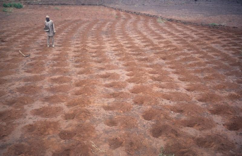
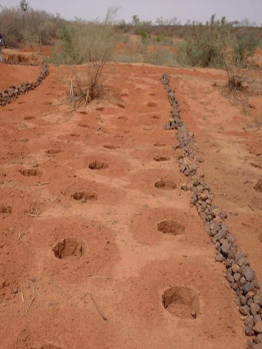
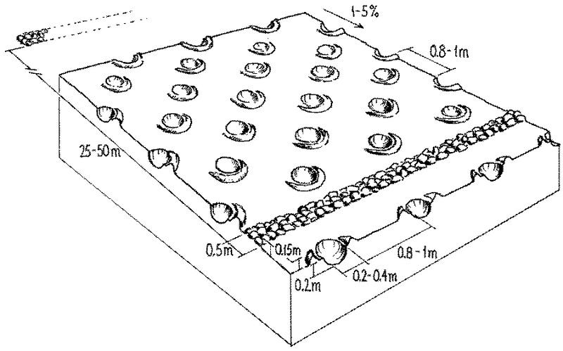
The combination of planting pits (tassa) with stone lines is used for the rehabilitation of degraded, crusted land. This technology is mainly applied in semi-arid areas on sandy/loamy plains, often covered with a hard pan, and with slopes below 5%. These denuded plains are brought into crop cultivation by the combination of tassa and stone lines. Planting pits are holes of 20-30 cm diameter and 20-25 cm depth, spaced about 1 m apart in each direction. The excavated earth is formed into a small ridge downslope of the pit. Manure is added to each pit, but its availability is sometimes a problem. At the start of the rainy season, millet or sorghum is sown in these pits. The overall aim of the system is to capture and hold
rainfall and runoff, and thereby improve water infiltration, while increasing nutrient availability.
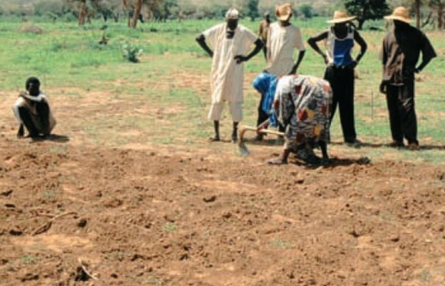
Stone lines are small structures, at most three stones wide and sometimes only one stone high. The distance between the lines is a function of the slope and availability of stone. Typically they are sited 25-50 m apart on 2-5% slopes. Stones are usually collected from nearby sites - though sometimes up to 5-10 km away and brought to the fields by donkey carts or lorries (when a project is involved). They are positioned manually, along the contour. Stone lines are intended to slow down runoff. They thereby increase the rate of infiltration, while simultaneously protecting the planting pits from sedimentation.
Often grass establishes between the stones, which helps increase infiltration further and accelerates the accumulation of fertile sediment. Wind-blown particles may also build up along the stone lines due to a local reduction in wind velocity. The accumulation of sediment along the stone lines in turn favours water infiltration on the upslope side. This then improves plant growth, which further enhances the effect of the system. Construction does not require heavy machinery (unless the stones need to be brought from afar by lorry).
The technique is therefore favourable to spontaneous adoption. Stone lines may need to be repaired annually, especially if heavy rains have occurred. Manure is placed every second (or third) year into the previously dug pits and sand is removed annually: normally the highest plant production is during the second year after manure application.
2.3 ຮູບພາບຂອງເຕັກໂນໂລຢີ
ສື່ຮູບພາບ
2.5 ປະເທດ / ເຂດ / ສະຖານທີ່ບ່ອນທີ່ ເຕັກໂນໂລຢີ ໄດ້ຮັບການນໍາໃຊ້ ແລະ ທີ່ຖືກປົກຄຸມດ້ວຍການປະເມີນຜົນ
ປະເທດ:
ໄນເຈີ
ພາກພື້ນ / ລັດ / ແຂວງ:
Niger, Tahoua
ໃຫ້ລະບຸ ການແຜ່ຂະຫຍາຍ ເຕັກໂນໂລຢີ:
- ແຜ່ຂະຫຍາຍຢ່າງໄວວາໃນພື້ນທີ່
ຖ້າຫາກວ່າເຕັກໂນໂລຢີ ໄດ້ກະຈາຍໄປທົ່ວພື້ນທີ່, ໃຫ້ລະບຸເນື້ອທີ່ ທີ່ຖືກປົກຄຸມ (ເປັນ ກິໂລຕາແມັດ):
40.0
ຄວາມຄິດເຫັນ:
Total area covered by the SLM Technology is 40 km2.
2.7 ການນໍາສະເໜີ ເຕັກໂນໂລຢີ
ໃຫ້ລະບຸ ເຕັກໂນໂລຢີ ໄດ້ຖືກຈັດຕັ້ງປະຕິບັດຄືແນວໃດ?
- ໂດຍຜ່ານໂຄງການ / ການຊ່ວຍເຫຼືອຈາກພາຍນອກ
3. ການໃຈ້ແຍກ ເຕັກໂນໂລຢີ ໃນການຄຸ້ມຄອງ ດິນແບບຍືນຍົງ
3.1 ຈຸດປະສົງຫຼັກ (ຫຼາຍ) ຂອງເຕັກໂນໂລຢີ
- ຫຼຸດຜ່ອນ, ປ້ອງກັນ, ຟື້ນຟູ ການເຊື່ອມໂຊມຂອງດິນ
3.2 ປະເພດການນໍາໃຊ້ທີ່ດິນ ໃນປະຈຸບັນ() ທີ່ເຕັກໂນໂລຢີ ໄດ້ຖືກນໍາໃຊ້

ດິນທີ່ປູກພືດ
- ການປູກພືດປະຈໍາປີ
ການປູກພືດປະຈຳປີ - ລະບຸປະເພດພືດ:
- ທັນຍາພືດ-ເຂົ້າຟາງ
- ທັນຍາພືດ-ເຂົ້າຟາງ
- ພືດຕະກູນຖົ່ວ ແລະ ຖົ່ວແປກ
ຄວາມຄິດເຫັນ:
major food crop: Millet and sorghum
Major land use problems (compiler’s opinion): Soil fertility decline is the basic problem: this is due to degradation and nutrient mining. Loss of limited rainwater by runoff and loss of soil cover result in low crop production and food insufficiency. This occurs in combination with lack of pasture, resulting in shortage of manure.
3.4 ການສະໜອງນ້ຳ
ການສະໜອງນໍ້າ ໃນພື້ນທີ່ ທີ່ໄດ້ນໍາໃຊ້ ເຕັກໂນໂລຢີ:
- ນໍ້າຝົນ
3.5 ການນໍາໃຊ້ເຕັກໂນໂລຢີ ທີ່ຢູ່ໃນກຸ່ມການຄຸ້ມຄອງ ທີ່ດິນແບບຍືນຍົງ
- ການເກັບກັກນໍ້າ
- ການຄຸ້ມຄອງຊົນລະປະທານ (ການສະໜອງນໍ້າ, ລະບາຍ)
3.6 ມາດຕະການ ການຄຸ້ມຄອງ ທີ່ດິນແບບຍືນຍົງ ປະກອບດ້ວຍ ເຕັກໂນໂລຢີ

ມາດຕະການ ທາງການກະສິກໍາ
- A7: ອື່ນໆ

ມາດຕະການໂຄງສ້າງ
- S11: ອື່ນໆ
ຄວາມຄິດເຫັນ:
Specification of other agronomic measures: Manure application (supplementary)
Specification of other structural measures: stone lines, planting pits
Type of agronomic measures: manure / compost / residues
3.7 ປະເພດດິນເຊື່ອມໂຊມ ຫຼັກທີ່ໄດ້ນໍາໃຊ້ ເຕັກໂນໂລຢີ

ດິນເຊາະເຈື່ອນ ໂດຍນໍ້າ
- Wt: ການສູນເສຍຊັ້ນໜ້າດິນ / ການເຊາະເຈື່ອນຜິວໜ້າດິນ

ດິນເຊາະເຈື່ອນ ໂດຍລົມ
- ການສູນເສຍຊັ້ນໜ້າດິນ

ການເຊື່ອມໂຊມ ຂອງດິນ ທາງເຄມີ
- Cn: ຄວາມອຸດົມສົມບູນ ລົດໜ້ອຍຖອຍລົງ ແລະ ສານອິນຊີວັດຖຸລົດລົງ (ບໍ່ແມ່ນສາເຫດມາຈາກການເຊາະເຈື່ອນ)

ການເຊື່ອມໂຊມ ຂອງດິນ ທາງກາຍະພາບ
- Pc: ການອັດແໜ້ນ
- Pk: ການບັນເທົາ ແລະ ການປົກຄຸມຂອງເປືອກໂລກ
ຄວາມຄິດເຫັນ:
Main type of degradation addressed: Wt: loss of topsoil / surface erosion, Et: loss of topsoil, Cn: fertility decline and reduced organic matter content, Pc: compaction, Pk: sealing and crusting
3.8 ການປ້ອງກັນ, ການຫຼຸດຜ່ອນ, ຫຼືການຟື້ນຟູຂອງການເຊື່ອມໂຊມຂອງດິນ
ໃຫ້ລະບຸ ເປົ້າໝາຍ ເຕັກໂນໂລຢີ ທີ່ພົວພັນ ກັບຄວາມເຊື່ອມໂຊມຂອງດິນ:
- ການຟື້ນຟູ / ຟື້ນຟູດິນທີ່ຊຸດໂຊມ
4. ຂໍ້ກໍາໜົດ, ກິດຈະກໍາການປະຕິບັດ, ວັດຖຸດິບ, ແລະຄ່າໃຊ້ຈ່າຍ
4.1 ເຕັກນິກ ໃນການແຕ້ມແຜນວາດ ເຕັກໂນໂລຢີ
ຄຸນລັກສະນະ ຂອງເຕັກນິກ (ທີ່ກ່ຽວຂ້ອງ ກັບການແຕ້ມແຜນວາດ ທາງດ້ານເຕັກນີກ):
Planting pits (tassa) capture rainfall runoff for cultivation of annual crops, and the stone lines - spaced at 25-50 metres apart - help hold back moisture and eroded soil.
Technical knowledge required for field staff / advisors: moderate
Technical knowledge required for land users: low
Main technical functions: increase in organic matter, increase of infiltration, increase / maintain water stored in soil, water harvesting / increase water supply, increase in soil fertility, increases natural regeneration of trees
Secondary technical functions: reduction of slope length, improvement of ground cover, improvement of soil structure
Manure / compost / residues
Quantity/ density: 2.5 t/ha
Structural measure: stone lines
Spacing between structures (m): 25-50planting pits
Structural measure: planting pits
Vertical interval between structures (m): 1
Spacing between structures (m): 1
Depth of ditches/pits/dams (m): 0.2-0.25
Width of ditches/pits/dams (m): 0.2-0.3
Slope (which determines the spacing indicated above): <5%
ຜູ້ຂຽນ:
Mats Gurtner
4.2 ຂໍ້ມູນທົ່ວໄປກ່ຽວກັບການຄິດໄລ່ປັດໃຈຂາເຂົ້າໃນການຜະລິດ ແລະ ມູນຄ່າອື່ນໆ
ລະບຸ ສະກຸນເງິນທີ່ໃຊ້ສໍາລັບ ການຄິດໄລ່ຄ່າໃຊ້ຈ່າຍ:
- USA
4.3 ການສ້າງຕັ້ງກິດຈະກໍາ
| ກິດຈະກໍາ | Timing (season) | |
|---|---|---|
| 1. | Digging pits (tassa): the excavated earth | dry season (November to May) |
| 2. | Digging out stones from nearby sites | dry season (November to May) |
| 3. | Transporting stones | dry season (November to May) |
| 4. | Aligning the stones along the contour with the help of a ‘water tube | dry season (November to May) |
4.4 ຕົ້ນທຶນ ແລະ ປັດໄຈຂາເຂົ້າທີ່ຈໍາເປັນໃນຈັດຕັ້ງປະຕິບັດ
| ລະບຸ ປັດໃຈ ນໍາເຂົ້າ ໃນການຜະລີດ | ຫົວໜ່ວຍ | ປະລິມານ | ຕົ້ນທຶນ ຕໍ່ຫົວໜ່ວຍ | ຕົ້ນທຶນທັງໝົດ ຂອງປັດໃຈຂາເຂົ້າ ໃນການຜະລິດ | % ຂອງຕົ້ນທຶນທັງໝົດ ທີ່ຜູ້ນໍາໃຊ້ທີ່ດິນ ໃຊ້ຈ່າຍເອງ | |
|---|---|---|---|---|---|---|
| ແຮງງານ | Digging tassa | persons/day/ha | 100.0 | 1.5 | 150.0 | 100.0 |
| ແຮງງານ | Building stone lines | persons/day/ha | 26.666 | 1.5 | 40.0 | 100.0 |
| ອຸປະກອນ | Tools for tassa | ha | 1.0 | 5.0 | 5.0 | 100.0 |
| ອຸປະກອນ | Tools for stone lines | ha | 1.0 | 5.0 | 5.0 | 75.0 |
| ຝຸ່ນ ແລະ ຢາຊີວະພາບ | Compost/manure | ha | 1.0 | 5.0 | 5.0 | 100.0 |
| ອື່ນໆ | Transporting stones with lorri | ha | 1.0 | 40.0 | 40.0 | |
| ຕົ້ນທຶນທັງໝົດ ໃນການຈັດຕັ້ງປະຕິບັດ ເຕັກໂນໂລຢີ | 245.0 | |||||
| ຄ່າໃຊ້ຈ່າຍທັງໝົດ ສຳລັບການສ້າງຕັ້ງເຕັກໂນໂລຢີ ເປັນສະກຸນເງີນໂດລາ | 245.0 | |||||
ຄວາມຄິດເຫັນ:
Duration of establishment phase: 12 month(s)
4.5 ບໍາລຸງຮັກສາ / ແຜນຈັດຕັ້ງປະຕິບັດ ກິດຈະກໍາ
| ກິດຈະກໍາ | ໄລຍະເວລາ / ຄວາມຖີ່ | |
|---|---|---|
| 1. | Manuring the pits with approx 250 g per pit | dry season (November to May) / initial establishment |
| 2. | Manuring the pits with about 250 g per pit (2.5 t/ha) | October/November or March-May / every second year |
| 3. | Removing sand from the tassa | March-May/annual |
| 4. | Check and repair stone lines | annually and after heavy rains. |
4.6 ຄ່າໃຊ້ຈ່າຍ ແລະ ປັດໄຈນໍາເຂົ້າທີ່ຈໍາເປັນສໍາລັບການບໍາລຸງຮັກສາກິດຈະກໍາ / ແຜນປະຕິບັດ (ຕໍ່ປີ)
| ລະບຸ ປັດໃຈ ນໍາເຂົ້າ ໃນການຜະລີດ | ຫົວໜ່ວຍ | ປະລິມານ | ຕົ້ນທຶນ ຕໍ່ຫົວໜ່ວຍ | ຕົ້ນທຶນທັງໝົດ ຂອງປັດໃຈຂາເຂົ້າ ໃນການຜະລິດ | % ຂອງຕົ້ນທຶນທັງໝົດ ທີ່ຜູ້ນໍາໃຊ້ທີ່ດິນ ໃຊ້ຈ່າຍເອງ | |
|---|---|---|---|---|---|---|
| ແຮງງານ | Labour | persons/day/ha | 21.0 | 1.5 | 31.5 | 100.0 |
| ອຸປະກອນ | Tools for tassa | ha | 1.0 | 1.0 | 1.0 | 100.0 |
| ຝຸ່ນ ແລະ ຢາຊີວະພາບ | Compost/manure | ha | 1.0 | 2.5 | 2.5 | 100.0 |
| ຕົ້ນທຶນທັງໝົດ ທີ່ໃຊ້ໃນການບໍາລຸງຮັກສາ ເຕັກໂນໂລຢີ | 35.0 | |||||
| ຄ່າໃຊ້ຈ່າຍທັງໝົດ ສຳລັບການບົວລະບັດຮກສາເຕັກໂນໂລຢີ ເປັນສະກຸນເງີນໂດລາ | 35.0 | |||||
ຄວາມຄິດເຫັນ:
Machinery/ tools: hoe, pick-axe, shovel, donkey cart, (lorries)
The costs are based on 300 m of stone lines per hectare (on a 3-4% slope). Maintenance costs refer to removing sand from the pits from the second year onwards, and to the application of manure every second year (costs are spread on an annual basis). If applicable, costs for transporting the manure need to be added. The general assumption in these calculations is that adequate manure is readily available close by. The availability of stones is the main factor in determining costs - though labour availability can affect prices also. If stones are not available in the field or nearby (from where they can be transported by donkey cart), they have to be carried by lorries, which is much more expensive. The costs here refer to fuel costs only, paid by a project: they do not include depreciation of lorries.
5. ສະພາບແວດລ້ອມທໍາມະຊາດ ແລະ ມະນຸດ
5.1 ອາກາດ
ປະລິມານນໍ້າຝົນປະຈໍາປີ
- < 250 ມີລິແມັດ
- 251-500 ມີລິແມັດ
- 501-750 ມີລິແມັດ
- 751-1,000 ມີລິແມັດ
- 1,001-1,500 ມີລິແມັດ
- 1,501-2,000 ມີລິແມັດ
- 2,001-3,000 ມີລິແມັດ
- 3,001-4,000 ມີລິແມັດ
- > 4,000 ມີລິແມັດ
ໃຫ້ລະບຸສະເລ່ຍ ປະລິມານນໍ້າຝົນຕົກປະຈໍາປີ ເປັນມິນລິແມັດ (ຖ້າຫາກຮູ້ຈັກ):
390.00
ເຂດສະພາບອາກາດກະສິກໍາ
- ເຄິ່ງແຫ້ງແລ້ງ
5.2 ພູມິປະເທດ
ຄ່າສະເລ່ຍ ຄວາມຄ້ອຍຊັນ:
- ພື້ນທີ່ຮາບພຽງ (0-2%)
- ອ່ອນ (3-5 %)
- ປານກາງ (6-10 %)
- ມ້ວນ (11-15 %)
- ເນີນ(16-30%)
- ໍຊັນ (31-60%)
- ຊັນຫຼາຍ (>60%)
ຮູບແບບຂອງດິນ:
- ພູພຽງ / ທົ່ງພຽງ
- ສັນພູ
- ເປີ້ນພູ
- ເນີນພູ
- ຕີນພູ
- ຮ່ອມພູ
ເຂດລະດັບສູງ:
- 0-100 ແມັດ a.s.l.
- 101-500 ແມັດ a.s.l.
- 501-1,000 ແມັດ a.s.l.
- 1,001-1,500 ແມັດ a.s.l.
- 1,501-2,000 ແມັດ a.s.l.
- 2,001-2,500 ແມັດ a.s.l.
- 2,501-3,000 ແມັດ a.s.l.
- 3,001-4,000 ແມັດ a.s.l.
- > 4,000 ແມັດ a.s.l.
5.3 ດິນ
ຄວາມເລິກ ຂອງດິນສະເລ່ຍ:
- ຕື້ນຫຼາຍ (0-20 ຊັງຕີແມັດ)
- ຕື້ນ (21-50 ຊຕມ)
- ເລີກປານກາງ (51-80 ຊຕມ)
- ເລິກ (81-120 ຊມ)
- ເລິກຫຼາຍ (> 120 cm)
ເນື້ອດິນ (ໜ້າດິນ):
- ຫຍາບ / ເບົາ (ດິນຊາຍ)
- ປານກາງ (ດິນໜຽວ, ດິນໂຄນ)
ຊັ້ນອິນຊີວັດຖຸ ເທິງໜ້າດິນ:
- ຕໍາ່ (<1 %)
ຖ້າເປັນໄປໄດ້ ແມ່ນໃຫ້ຕິດຄັດ ການພັນລະນາດິນ ຫຼື ຂໍ້ມູນສະເພາະຂອງດິນ, ຕົວຢ່າງ, ຄຸນລັກສະນະ ປະເພດຂອງດິນ, ຄ່າຄວາມເປັນກົດ / ເປັນດ່າງຂອງດິນ, ສານອາຫານ, ດິນເຄັມ ແລະ ອື່ນໆ.
Soil depth on average: Also deep
Soil fertility is low - very low
Soil drainage / infiltration is good, though infiltration is low where there is a crust
5.6 ຄຸນລັກສະນະ ຂອງຜູ້ນໍາໃຊ້ທີ່ດິນ ທີ່ໄດ້ນໍາໃຊ້ເຕັກໂນໂລຢີ
ລະບົບ ການຕະຫຼາດ ແລະ ຜົນຜະລິດ:
- ກຸ້ມຕົນເອງ (ພໍພຽງ)
- ປະສົມປົນເປ( ກຸ້ມຕົນເອງ/ເປັນສິນຄ້າ)
ລາຍຮັບ ທີ່ບໍ່ໄດ້ມາຈາກ ການຜະລິດ ກະສິກໍາ:
- > 50 % ຂອງລາຍຮັບທັງໝົດ
ລະດັບ ການຫັນເປັນກົນຈັກ:
- ການໃຊ້ແຮງງານຄົນ
- ສັດລາກແກ່
ໃຫ້ລະບຸ ຄຸນລັກສະນະ ຂອງຜູ້ນໍາໃຊ້ທີ່ດິນ:
Off-farm income specification: remittances from out-migration of labour, commerce and crafts
5.7 ເນື້ອທີ່ສະເລ່ຍຂອງດິນ ທີ່ຜູ້ນຳໃຊ້ທີ່ດິນ ໃຊ້ເຮັດເຕັກໂນໂລຢີ
- <0.5 ເຮັກຕາ
- 0.5-1 ເຮັກຕາ
- 1-2 ເຮັກຕາ
- 2-5 ເຮັກຕາ
- 5-15 ເຮັກຕາ
- 15-50 ເຮັກຕາ
- 50-100 ເຮັກຕາ
- 100-500 ເຮັກຕາ
- 500-1,000 ເຮັກຕາ
- 1,000-10,000 ເຮັກຕາ
- > 10,000 ເຮັກຕາ
5.8 ເຈົ້າຂອງທີ່ດິນ, ສິດໃຊ້ທີ່ດິນ, ແລະ ສິດທິການນໍາໃຊ້ນໍ້າ
ເຈົ້າຂອງດິນ:
- ບຸກຄົນ, ທີ່ມີຕໍາແໜ່ງ
ສິດທິ ໃນການນໍາໃຊ້ທີ່ດິນ:
- ບຸກຄົນ
6. ຜົນກະທົບ ແລະ ລາຍງານສະຫຼຸບ
6.1 ການສະແດງຜົນກະທົບ ພາຍໃນພື້ນທີ່ ທີ່ໄດ້ຈັດຕັ້ງປະຕິບັດ ເຕັກໂນໂລຢີ
ຜົນກະທົບທາງເສດຖະກິດສັງຄົມ
ການຜະລິດ
ການຜະລິດພືດ
ລາຍໄດ້ ແລະ ຄ່າໃຊ້ຈ່າຍ
ລາຍຮັບ ຈາກການຜະລີດ
ມີວຽກໜັກ
ຜົນກະທົບທາງດ້ານເສດຖະກິດສັງຄົມອື່ນໆ
input contstraints
ຜົນກະທົບດ້ານວັດທະນາທໍາສັງຄົມ
ສະຖາບັນ ການຈັດຕັ້ງຊຸມຊົນ
ຄວາມຄິດເຫັນ / ລະບຸແຈ້ງ:
Through mutual aid in technology implementation
ຄວາມຮູ້ກ່ຽວກັບ ການຄຸ້ມຄອງ ທີ່ດິນແບບຍືນຍົງ / ການເຊື່ອມໂຊມຂອງດິນ
ການຫຼຸດຜ່ອນ ຂໍ້ຂັດແຍ່ງ
ຄວາມຄິດເຫັນ / ລະບຸແຈ້ງ:
Land use rights conflicts of rehabilitated land and conflicts between farmers and pastoralists, because pasture land is being turned into cultivated fields
ຜົນກະທົບຕໍ່ລະບົບນິເວດ
ວົງຈອນນໍ້າ / ນໍ້າ
ການລະບາຍນໍ້າ
ດິນ
ຄວາມຊຸ່ມຂອງດິນ
ການສູນເສຍດິນ
ອິນຊີວັດຖຸໃນດິນ / ຢູ່ລຸ່ມຊັ້ນດິນ C
ຜົນກະທົບຕໍ່ລະບົບນິເວດອື່ນໆ
soil fertility
long-term soil cover
6.2 ຜົນກະທົບທາງອ້ອມ ຈາກການນໍາໃຊ້ເຕັກໂນໂລຢີ
ນໍ້າຖ້ວມຢູ່ເຂດລຸ່ມນໍ້າ
ການທັບຖົມ ຂອງດິນຕະກອນ ຢູ່ເຂດລຸ່ມນໍ້າ
6.4 ການວິເຄາະຕົ້ນທຶນ ແລະ ຜົນປະໂຫຍດ
ຈະເຮັດປະໂຫຍດເພື່ອປຽບທຽບກັບຄ່າໃຊ້ຈ່າຍກັບສິ່ງກໍ່ສ້າງ (ຈາກທັດສະນະຂອງຜູ້ນຳໃຊ້ທີ່ດິນ) ໄດ້ແນວໃດ?
ຜົນຕອບແທນ ໃນໄລຍະສັ້ນ:
ຜົນກະທົບທາງບວກ
ຜົນຕອບແທນ ໃນໄລຍະຍາວ:
ຜົນກະທົບທາງບວກຫຼາຍ
ຈະໄດ້ຮັບຜົນປະໂຫຍດເມື່ອປຽບທຽບກັບ / ຄ່າໃຊ້ຈ່າຍໃນການບຳລຸງຮັກສາທີເ່ກີດຂື້ນອິກ (ຈາກທັດສະນະຄະຕິຂອງຜູ້ນຳໃຊ້ທີ່ດິນ) ໄດ້ແນວໃດ?
ຜົນຕອບແທນ ໃນໄລຍະສັ້ນ:
ຜົນກະທົບທາງບວກ
ຜົນຕອບແທນ ໃນໄລຍະຍາວ:
ຜົນກະທົບທາງບວກຫຼາຍ
6.5 ການປັບຕົວຮັບເອົາເຕັກໂນໂລຢີ
ຄວາມຄິດເຫັນ:
There is a moderate trend towards spontaneous adoption of the Technology
Comments on adoption trend: There is moderate growing spontaneous adoption (for rehabilitation of the plains), but there are no estimates available regarding the extent.
6.7 ຈຸດແຂງ / ຂໍ້ດີ / ໂອກາດ ໃນການນໍາໃຊ້ ເຕັກໂນໂລຢີ
| ຈຸດແຂງ / ຈຸດດີ / ໂອກາດ ຈາກທັດສະນະຂອງຜູ້ປ້ອນຂໍ້ມູນ ຫຼື ບຸກຄົນສຳຄັນ |
|---|
|
Simple technology, individually applicable in the dry season, requiring only very little training/knowledge and no special equipment. |
| Making best use of manure, which is a limiting resource. |
| Increase in agricultural production. |
| Rehabilitation of degraded and denuded land: bringing back into production formerly uncultivated land; extension of farm land to the plateaus. |
6.8 ຈຸດອ່ອນ / ຂໍ້ເສຍ / ຄວາມສ່ຽງ ໃນການນໍາໃຊ້ ເຕັກໂນໂລຢີ ແລະ ວິທີການແກ້ໄຂບັນຫາ
| ຈຸດອ່ອນ/ຂໍ້ບົກຜ່ອງ/ຄວາມສ່ຽງ ຈາກທັດສະນະຂອງຜູ້ປ້ອນຂໍ້ມູນ ຫຼື ບຸກຄົນສຳຄັນ | ມີວິທີການແກ້ໄຂຄືແນວໃດ? |
|---|---|
| Labour demanding technology for implementation and maintenance | Mechanisation of tasks: transportation of stones and manure. However, this would raise the cost. |
| Instability of planting pits in loose soil, increased erosion on steeper slopes and with heavier rains |
Avoid loose sandy soils and steep slopes. |
|
The effectiveness can be compromised if the various geo-morphological units (plateaus, slopes) are not treated simultaneously |
Catchment area approach if downstream flooding is an issue. |
|
Possibility of land use conflicts concerning rehabilitated land, in particular with pastoralists |
Better coordination/consultation before implementing the technology in an area. |
| Implementation constraint: availability of manure and/or stones and transporting manure/stones to the plateaus and slopes | Subsidise transport means (or supply donkey carts) or/and apply stone lines only in areas where there are stones available close to the fields. |
7. ເອກະສານອ້າງອີງ ແລະ ການເຊື່ອມຕໍ່
7.1 ວິທີການ / ແຫຼ່ງຂໍ້ມູນ
7.2 ເອກກະສານອ້າງອີງທີ່ເປັນບົດລາຍງານ
ຫົວຂໍ້, ຜູ້ຂຽນ, ປີ, ISBN:
Bety A, Boubacar A, Frölich W, Garba A, Kriegl M, Mabrouk A, Noufou O, Thienel M and Wincker H: Gestion durable desressources naturelles. Leçons tirées du savoir des paysans de l’Adar. Ministère de l’agriculture et de l’élevage, Niamey, 142 pp.. 19
ຫົວຂໍ້, ຜູ້ຂຽນ, ປີ, ISBN:
Hassane A, Martin Pand Reij C:Water harvesting, land rehabilitation and household food security in Niger: IFAD’s Soil and Water Conservation Project in IllelaDistrict. IFAD, Rome, 51 pp.. 2000.
ຫົວຂໍ້, ຜູ້ຂຽນ, ປີ, ISBN:
Mabrouk A, Tielkes E and Kriegl M: Conservation des eaux et des sols: Leçons des connaissances traditionnelles de la région de Tahoua, Niger. In: Renard, G., Neef, A,. Becker, K. and Von Oppen, M. (eds). de la région de Tahoua, Niger. 1998.
ຫົວຂໍ້, ຜູ້ຂຽນ, ປີ, ISBN:
Mabrouk A, Tielkes E and Kriegl M: Conservation des eaux et des sols: Leçons des connaissances traditionnelles de la région de Tahoua, Niger. In: Renard, G., Neef, A,. Becker, K. and Von Oppen, M. (eds). de la région de Tahoua, Niger. 1998.
ຫົວຂໍ້, ຜູ້ຂຽນ, ປີ, ISBN:
Mabrouk A, Tielkes E and Kriegl M: Conservation des eaux et des sols: Leçons des connaissances traditionnelles de la région de Tahoua, Niger. In: Renard, G., Neef, A,. Becker, K. and Von Oppen, M. (eds). de la région de Tahoua, Niger. 1998.
ຫົວຂໍ້, ຜູ້ຂຽນ, ປີ, ISBN:
Mabrouk A, Tielkes E and Kriegl M: Conservation des eaux et des sols: Leçons des connaissances traditionnelles de la région de Tahoua, Niger. In: Renard, G., Neef, A,. Becker, K. and Von Oppen, M. (eds). de la région de Tahoua, Niger. 1998.
ຫົວຂໍ້, ຜູ້ຂຽນ, ປີ, ISBN:
Mabrouk A, Tielkes E and Kriegl M: Conservation des eaux et des sols: Leçons des connaissances traditionnelles de la région de Tahoua, Niger. In: Renard, G., Neef, A,. Becker, K. and Von Oppen, M. (eds). de la région de Tahoua, Niger. 1998.
ຫົວຂໍ້, ຜູ້ຂຽນ, ປີ, ISBN:
Mabrouk A, Tielkes E and Kriegl M: Conservation des eaux et des sols: Leçons des connaissances traditionnelles de la région de Tahoua, Niger. In: Renard, G., Neef, A,. Becker, K. and Von Oppen, M. (eds). de la région de Tahoua, Niger. 1998.
ຫົວຂໍ້, ຜູ້ຂຽນ, ປີ, ISBN:
Mabrouk A, Tielkes E and Kriegl M: Conservation des eaux et des sols: Leçons des connaissances traditionnelles de la région de Tahoua, Niger. In: Renard, G., Neef, A,. Becker, K. and Von Oppen, M. (eds). de la région de Tahoua, Niger. 1998.
ຫົວຂໍ້, ຜູ້ຂຽນ, ປີ, ISBN:
Mabrouk A, Tielkes E and Kriegl M: Conservation des eaux et des sols: Leçons des connaissances traditionnelles de la région de Tahoua, Niger. In: Renard, G., Neef, A,. Becker, K. and Von Oppen, M. (eds). de la région de Tahoua, Niger. 1998.
ຂໍ້ມູນການເຊື່ອມຕໍ່ ແລະ ເນື້ອໃນ
ຂະຫຍາຍທັງໝົດ ຍຸບທັງໝົດການເຊື່ອມຕໍ່
Approche participative de réhabilitation des terres individuelles et … [ໄນເຈີ]
Planification et gestion des terres individuelles et villageoises sur la base d’une participation des usagers ; promotion simultanée des activités des femmes.
- ຜູ້ສັງລວມຂໍ້ມູນ: Eric Tielkes
ເນື້ອໃນ
ບໍ່ມີເນື້ອໃນ