Natural Vegetative Strips (NVS) [ຟີລິປິນ]
- ການສ້າງ:
- ປັບປູງ:
- ຜູ້ສັງລວມຂໍ້ມູນ: Philippine Overview of Conservation Approaches and Technologies
- ບັນນາທິການ: –
- ຜູ້ທົບທວນຄືນ: Mathias Gurtner, Deborah Niggli, Alexandra Gavilano
technologies_1133 - ຟີລິປິນ
ເບິ່ງພາກສ່ວນ
ຂະຫຍາຍທັງໝົດ ຍຸບທັງໝົດ1. ຂໍ້ມູນທົ່ວໄປ
1.2 ຂໍ້ມູນ ການຕິດຕໍ່ພົວພັນ ຂອງບຸກຄົນທີ່ສໍາຄັນ ແລະ ສະຖາບັນ ທີ່ມີສ່ວນຮ່ວມ ໃນການປະເມີນເອກກະສານ ເຕັກໂນໂລຢີ
ບັນດາຜູ້ຕອບແບບສອບຖາມທີ່ສໍາຄັນ ()
ຜຸ້ຊ່ຽວຊານ ດ້ານການຄຸ້ມຄອງ ທີ່ດິນແບບຍືນຍົງ:
MERCADO Agustin
International Center for Research in Agroforestry ICRAF
ອິນໂດເນເຊຍ
ຜຸ້ຊ່ຽວຊານ ດ້ານການຄຸ້ມຄອງ ທີ່ດິນແບບຍືນຍົງ:
Rondal José
Bureau of Soils and Water Management
ຟີລິປິນ
ຜຸ້ຊ່ຽວຊານ ດ້ານການຄຸ້ມຄອງ ທີ່ດິນແບບຍືນຍົງ:
Garrity Dennis
International Center for Research in Agroforestry ICRAF
ອິນໂດເນເຊຍ
ຊື່ໂຄງການ ທີ່ອໍານວຍຄວາມສະດວກ ໃນການສ້າງເອກກະສານ/ປະເມີນ ເຕັກໂນໂລຢີ (ຖ້າກ່ຽວຂ້ອງ)
Book project: where the land is greener - Case Studies and Analysis of Soil and Water Conservation Initiatives Worldwide (where the land is greener)ຊື່ສະຖາບັນ (ຫຼາຍສະຖາບັນ) ທີ່ອໍານວຍຄວາມສະດວກ ໃນການສ້າງເອກກະສານ / ປະເມີນ ເຕັກໂນໂລຢີ (ຖ້າກ່ຽວຂ້ອງ)
Bureau of Soils and Water Management (Bureau of Soils and Water Management) - ຟີລິປິນຊື່ສະຖາບັນ (ຫຼາຍສະຖາບັນ) ທີ່ອໍານວຍຄວາມສະດວກ ໃນການສ້າງເອກກະສານ / ປະເມີນ ເຕັກໂນໂລຢີ (ຖ້າກ່ຽວຂ້ອງ)
International Centre for Research in Agroforestry (ICRAF) - ເຄັນຢາ1.3 ເງື່ອນໄຂ ກ່ຽວກັບ ການນໍາໃຊ້ຂໍ້ມູນເອກະສານ ທີ່ສ້າງຂື້ນ ໂດຍຜ່ານ ອົງການພາບລວມຂອງໂລກ ທາງດ້ານແນວທາງ ແລະ ເຕັກໂນໂລຢີ ຂອງການອານຸລັກ ທໍາມະຊາດ (WOCAT)
ຜູ້ປ້ອນຂໍ້ມູນ ແລະ ບຸກຄົນສຳຄັນ ທີ່ໃຫ້ຂໍ້ມູນ (ຫຼາຍ) ຍິນຍອມ ຕາມເງື່ອນໄຂ ໃນການນຳໃຊ້ຂໍ້ມູນ ເພື່ອສ້າງເປັນເອກກະສານຂອງ WOCAT:
ແມ່ນ
1.4 ແຈ້ງການວ່າ ດ້ວຍຄວາມຍືນຍົງຂອງ ເຕັກໂນໂລຢີ
ການນໍາໃຊ້ ເຕັກໂນໂລຢີ ດັ່ງກ່າວໄດ້ອະທິບາຍ ເຖິງບັນຫາ ກ່ຽວກັບ ການເຊື່ອມໂຊມຂອງດິນບໍ? ຖ້າບໍ່ດັ່ງນັ້ນ ມັນບໍ່ສາມາດ ຢັ້ງຢືນໄດ້ວ່າ ເປັນເຕັກໂນໂລຊີ ໃນການຄຸ້ມຄອງ ທີ່ດິນແບບຍືນຍົງ? :
ບໍ່ແມ່ນ
1.5 ແບບສອບຖາມທີ່ອ້າງອີງເຖີງແນວທາງ ການຄຸ້ມຄອງທີ່ດິນແບບຍືນຍົງ (ໄດ້ເຮັດເປັນເອກະສານທີ່ໃຊ້ WOCAT)
LANDCARE - Claveria Landcare Association (CLCA) [ຟີລິປິນ]
Associations that help diffuse, at low cost, soil and water conservation technologies among upland farmers to generate income while conserving natural resources.
- ຜູ້ສັງລວມຂໍ້ມູນ: Romeo Villamin Labios
2. ການອະທິບາຍ ເຕັກໂນໂລຢີ ຂອງການຄຸ້ມຄອງ ທີ່ດິນແບບຍືນຍົງ
2.1 ຄໍາອະທິບາຍສັ້ນຂອງ ເຕັກໂນໂລຢີ
ການກຳໜົດຄວາມໝາຍ ຂອງເຕັກໂນໂລຢີ:
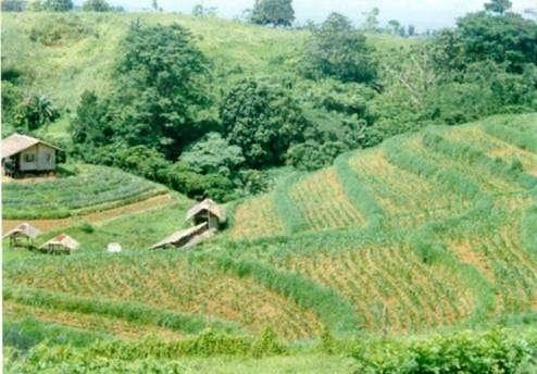
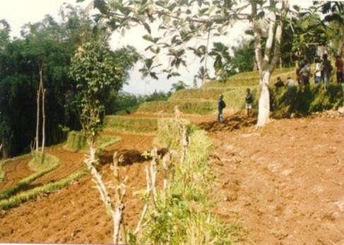
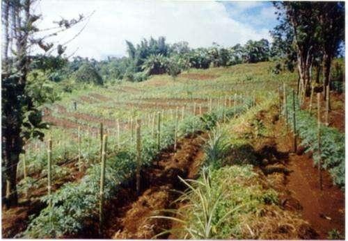
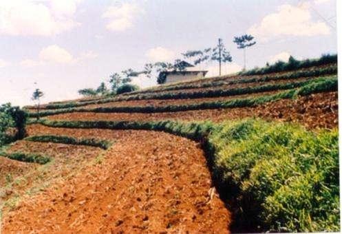
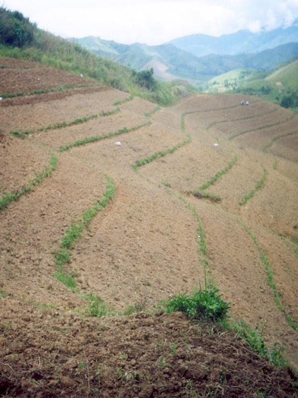
Within individual cropland plots, strips of land are marked out on the contour and left unploughed in order to form permanent, cross-slope barriers of naturally established grasses and herbs.
2.2 ການອະທິບາຍ ລາຍລະອຽດ ຂອງເຕັກໂນໂລຢີ
ການພັນລະນາ:
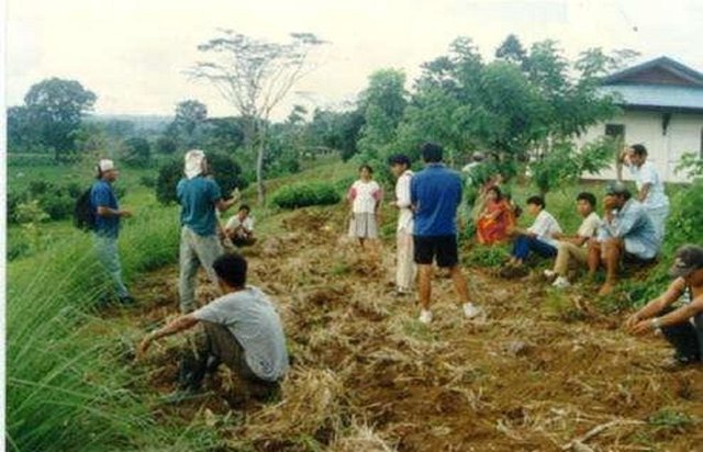
Natural vegetative strips (NVS) are narrow live barriers comprising naturally occurring grasses and herbs. Contour lines are laid out with an A-frame or through the ‘cow's back method’ (a cow is used to walk across the slope: it tends to follow the contour and this is confirmed when its back is seen to be level). The contours are then pegged to serve as an initial guide to ploughing. The 0.3-0.5 m wide strips are left unploughed to allow vegetation to establish. Runoff flowing down the slope during intense rain is slowed, and infiltrates when it reaches the vegetative strips. Eroded soil collects on and above the strips and natural terraces form over time. This levelling is assisted by ploughing along the contour between the NVS - through ‘tillage erosion’ - which also moves soil downslope.
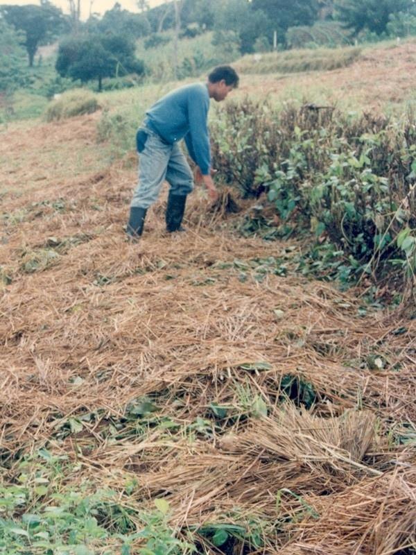
The vegetation on the established NVS needs to be cut back to a height of 5-10 cm: once before planting a crop, and once or twice during the cropping period. The cut material can be incorporated during land preparation, applied to the cropping area as mulch, or used as fodder. This depends on whether the farmer has livestock or not, on personal preference, and on the time of cutting. If the grass is applied as mulch or incorporated, the technology can be considered to be an agronomic, as well as a vegetative, measure.
NVS constitutes a low-cost technique because no planting material is required and only minimal labour is necessary for establishment and maintenance. Some farmers had already practiced the technology for several years before the intervention of the ICRAF (The World Agroforestry Centre) in 1993. ICRAF came to realise that farmers here preferred NVS to the recommended ‘contour barrier hedgerows’ of multipurpose trees- which land users viewed as being too labour intensive. When farmers became organised into ‘Landcare’ groups, NVS began to gain wide acceptance.
Land users appreciate the technique because it effectively controls soil erosion and prevents loss (through surface runoff) of fertilizers applied to the crop. As an option, some farmers plant fruit and timber trees, bananas or pineapples on or above the NVS. This may be during establishment of the contour lines, or later. The trees and other cash perennials provide an additional source of income, at the cost of some shading of the adjacent annual crops.
2.3 ຮູບພາບຂອງເຕັກໂນໂລຢີ
ສື່ຮູບພາບ
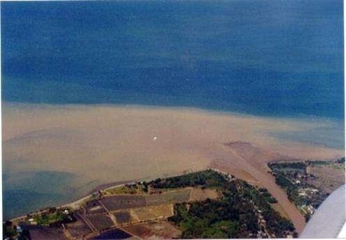
2.5 ປະເທດ / ເຂດ / ສະຖານທີ່ບ່ອນທີ່ ເຕັກໂນໂລຢີ ໄດ້ຮັບການນໍາໃຊ້ ແລະ ທີ່ຖືກປົກຄຸມດ້ວຍການປະເມີນຜົນ
ປະເທດ:
ຟີລິປິນ
ພາກພື້ນ / ລັດ / ແຂວງ:
Misamis Oriental
ຂໍ້ມູນເພີ່ມເຕີມຂອງສະຖານທີ່:
Bukidnon
ໃຫ້ລະບຸ ການແຜ່ຂະຫຍາຍ ເຕັກໂນໂລຢີ:
- ແຜ່ຂະຫຍາຍຢ່າງໄວວາໃນພື້ນທີ່
ຖ້າຫາກວ່າເຕັກໂນໂລຢີ ໄດ້ກະຈາຍໄປທົ່ວພື້ນທີ່, ໃຫ້ລະບຸເນື້ອທີ່ ທີ່ຖືກປົກຄຸມ (ເປັນ ກິໂລຕາແມັດ):
110.0
ຖ້າຫາກບໍ່ຮູ້ເນື້ອທີ່ທີ່ແນ່ນອນ, ໃຫ້ລະບຸ ເນື້ອທີ່ໂດຍປະມານ ທີ່ໃກ້ຄຽງ:
- 100-1,000 ກມ 2
ຄວາມຄິດເຫັນ:
The technology has been practiced by a few farmers for the past several years. With the entry of the International Centre for Research in Agroforestry (ICRAF) in 1993; farmers became organized and the technology gained wide adherence.
Total area covered by the SLM Technology is 110 km2. The technology has been practiced by a few farmers for the past several years. With the entry of the International Centre for Research in Agroforestry (ICRAF) in 1993; farmers became organized and the technology gained wide adherence.
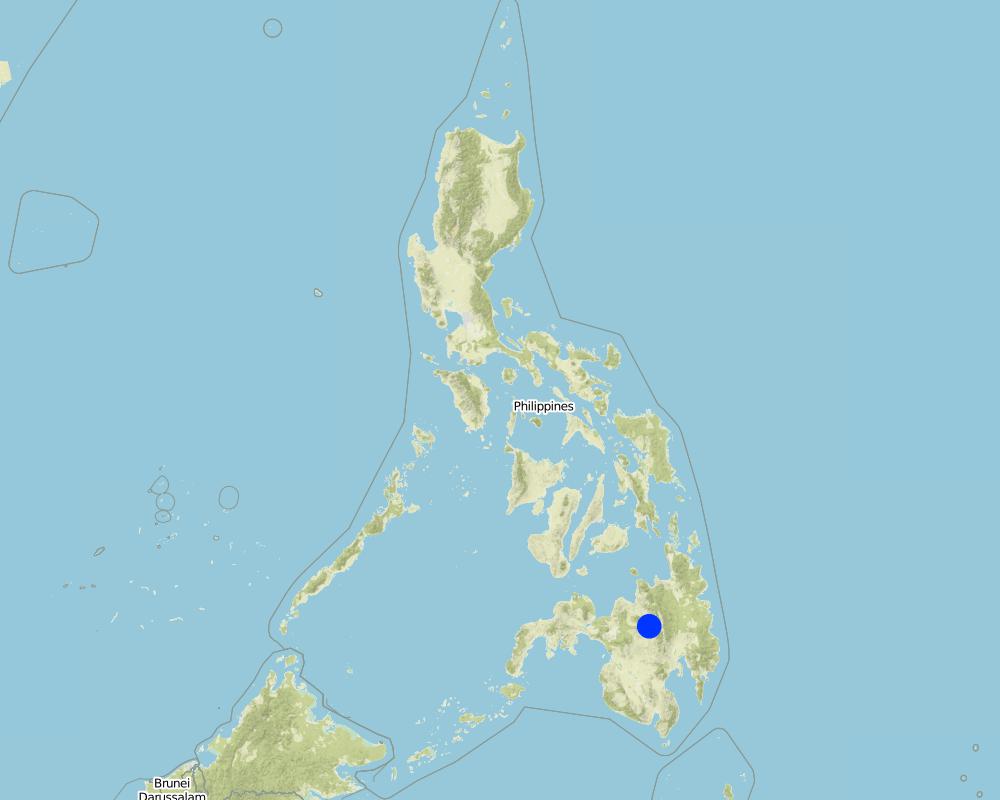
Map
×2.6 ວັນທີໃນການຈັດຕັ້ງປະຕິບັດ
ໃຫ້ລະບຸປີ ໃນການຈັດຕັ້ງປະຕິບັດ:
1993
ຖ້າຫາກວ່າ ບໍ່ຮູ້ຈັກ ປີທີ່ຊັດເຈນ ແມ່ນໃຫ້ປະມານ ວັນທີເອົາ:
- ຕໍ່າກວ່າ 10 ປີ ຜ່ານມາ (ມາເຖິງປະຈຸບັນ)
2.7 ການນໍາສະເໜີ ເຕັກໂນໂລຢີ
ໃຫ້ລະບຸ ເຕັກໂນໂລຢີ ໄດ້ຖືກຈັດຕັ້ງປະຕິບັດຄືແນວໃດ?
- ໂດຍຜ່ານໂຄງການ / ການຊ່ວຍເຫຼືອຈາກພາຍນອກ
ຄວາມຄິດເຫັນ (ປະເພດ ໂຄງການ ແລະ ອື່ນໆ):
It evolved in the area with some adaptations.
3. ການໃຈ້ແຍກ ເຕັກໂນໂລຢີ ໃນການຄຸ້ມຄອງ ດິນແບບຍືນຍົງ
3.1 ຈຸດປະສົງຫຼັກ (ຫຼາຍ) ຂອງເຕັກໂນໂລຢີ
- ຫຼຸດຜ່ອນ, ປ້ອງກັນ, ຟື້ນຟູ ການເຊື່ອມໂຊມຂອງດິນ
3.2 ປະເພດການນໍາໃຊ້ທີ່ດິນ ໃນປະຈຸບັນ() ທີ່ເຕັກໂນໂລຢີ ໄດ້ຖືກນໍາໃຊ້

ດິນທີ່ປູກພືດ
- ການປູກພືດປະຈໍາປີ
- ເປັນໄມ້ຢືນຕົ້ນ ແລະ ໄມ້ພຸ່ມ ຈາກການປູກພືດ
ການປູກພືດປະຈຳປີ - ລະບຸປະເພດພືດ:
- ທັນຍາພືດ-ສາລີ
- ທັນຍາພືດ-ເຂົ້າໄຮ່
- ຜັກ-ອື່ນໆ
ການປູກພືດທີ່ເປັນຕົ້ນໄມ້ ແລະ ໄມ້ພຸ່ມ - ລະບຸປະເພດພືດ:
- ໝາກໄມ້, ອື່ນໆ
- coffee
ຈໍານວນ ລະດູການ ປູກໃນປີໜຶ່ງ:
- 2
ລະບຸ ຊະນິດ:
Longest growing period: 240 days (Mar - Dec)
ຄວາມຄິດເຫັນ:
Main crops (cash and food crops): Maize, vegetables; coffee; fruit trees; upland rice
Major land use problems (compiler’s opinion): Loss of topsoil through sheet erosion and rills, leading to rapid soil fertility decline. In turn soil fertility decline results in the need for increasing levels of fertilizer inputs to maintain crop yield. However, these fertilizers are often washed away by surface runoff - a vicious circle.
Major land use problems (land users’ perception): Soil productivity decline; need more inputs to maintain crop yield.
3.4 ການສະໜອງນ້ຳ
ການສະໜອງນໍ້າ ໃນພື້ນທີ່ ທີ່ໄດ້ນໍາໃຊ້ ເຕັກໂນໂລຢີ:
- ນໍ້າຝົນ
3.5 ການນໍາໃຊ້ເຕັກໂນໂລຢີ ທີ່ຢູ່ໃນກຸ່ມການຄຸ້ມຄອງ ທີ່ດິນແບບຍືນຍົງ
- ມາດຕະການ ຕັດຂວາງ ກັບຄວາມຄ້ອຍຊັນ
3.6 ມາດຕະການ ການຄຸ້ມຄອງ ທີ່ດິນແບບຍືນຍົງ ປະກອບດ້ວຍ ເຕັກໂນໂລຢີ

ມາດຕະການ ທາງການກະສິກໍາ
- A1: ພືດ / ການປົກຫຸ້ມຂອງດິນ
- A2: ອິນຊີວັດຖຸ ຫຼື ຄວາມອຸດົມສົມບູນໃນດິນ
- A3: ການບໍາລຸງຮັກສາຊັ້ນໜ້າດິນ

ມາດຕະການ ທາງດ້ານພືດພັນ
- V2: ຫຍ້າ ແລະ ພືດສະໝູນໄພທີ່ເປັນໄມ້ຢືນຕົ້ນ
ຄວາມຄິດເຫັນ:
Type of agronomic measures: mixed cropping / intercropping, mulching, legume inter-planting, manure / compost / residues, contour tillage
Type of vegetative measures: aligned: -contour
3.7 ປະເພດດິນເຊື່ອມໂຊມ ຫຼັກທີ່ໄດ້ນໍາໃຊ້ ເຕັກໂນໂລຢີ

ດິນເຊາະເຈື່ອນ ໂດຍນໍ້າ
- Wt: ການສູນເສຍຊັ້ນໜ້າດິນ / ການເຊາະເຈື່ອນຜິວໜ້າດິນ
- Wg: ການເຊາະເຈື່ອນຮ່ອງນ້ຳ / ຫ້ວຍ

ການເຊື່ອມໂຊມ ຂອງດິນ ທາງເຄມີ
- Cn: ຄວາມອຸດົມສົມບູນ ລົດໜ້ອຍຖອຍລົງ ແລະ ສານອິນຊີວັດຖຸລົດລົງ (ບໍ່ແມ່ນສາເຫດມາຈາກການເຊາະເຈື່ອນ)
ຄວາມຄິດເຫັນ:
Main causes of degradation: deforestation / removal of natural vegetation (incl. forest fires) (caused massive erosion and loss of productivity), Lack of enforcement of legislat./authority (no clear cut policy and support from LGU). Secondary causes of degradation: overgrazing (over population of livestock, low land ratio), education, access to knowledge and support services (farmers are not fully aware of simple SWC approach), Agricultural causes (unsustainable practice in farming)
3.8 ການປ້ອງກັນ, ການຫຼຸດຜ່ອນ, ຫຼືການຟື້ນຟູຂອງການເຊື່ອມໂຊມຂອງດິນ
ໃຫ້ລະບຸ ເປົ້າໝາຍ ເຕັກໂນໂລຢີ ທີ່ພົວພັນ ກັບຄວາມເຊື່ອມໂຊມຂອງດິນ:
- ຫຼຸດຜ່ອນການເຊື່ອມໂຊມຂອງດິນ
ຄວາມຄິດເຫັນ:
Secondary goals: prevention of land degradation, rehabilitation / reclamation of denuded land
4. ຂໍ້ກໍາໜົດ, ກິດຈະກໍາການປະຕິບັດ, ວັດຖຸດິບ, ແລະຄ່າໃຊ້ຈ່າຍ
4.1 ເຕັກນິກ ໃນການແຕ້ມແຜນວາດ ເຕັກໂນໂລຢີ
ຄຸນລັກສະນະ ຂອງເຕັກນິກ (ທີ່ກ່ຽວຂ້ອງ ກັບການແຕ້ມແຜນວາດ ທາງດ້ານເຕັກນີກ):
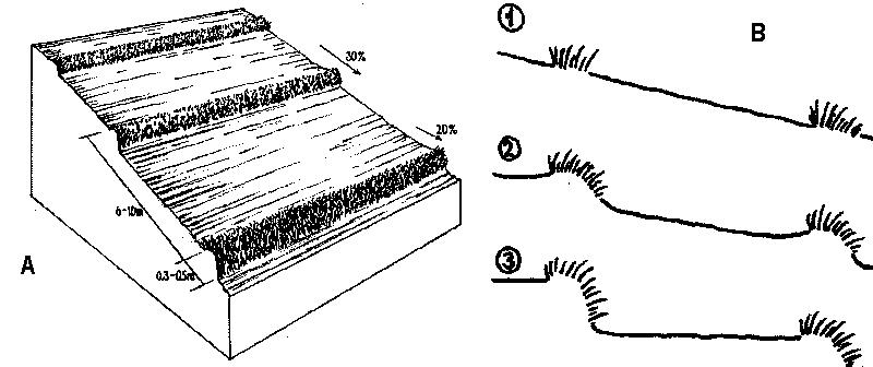
A - Spacing of natural vegetative strips depends on the slope.
B - The insert shows the evolution of terraces over time through tillage and soil erosion, leading to accumulation of sediment behind the strips (steps 1-3).
Technical knowledge required for field staff / advisors: moderate. Technical knowledge required for land users: moderate.
Main technical functions: reduction of slope angle, reduction of slope length, control of dispersed runoff. Secondary technical functions: improvement of ground cover, increase of infiltration, increase in soil fertility
Agronomic measures:
Mixed cropping / intercropping - Material/ species: annuals/perennials; Remarks: laid out alternately.
Mulching - Material/ species: crop residues; spread on the surface
Legume inter-planting - purpose: for nitrogen fixation
Manure / compost / residues - Material/ species: animal, crop residues
Contour tillage - Material/ species: Contour strips are laid into 6-10 meters apart depending on slope gradient.
Vegetative measures:
Aligned, along contour
Vegetative material: T : trees / shrubs, F : fruit trees / shrubs, C : perennial crops, G : grass, O : other
Vertical interval between rows / strips / blocks (m): 1
Spacing between rows / strips / blocks (m): 5
Vertical interval within rows / strips / blocks (m): 8
Width within rows / strips / blocks (m): 0.5
Narrow grass barriers
Vegetative material: grass
Number of plants per (ha): dense grass
Width within rows / strips / blocks (m): 0.5-0.7
Trees/ shrubs species: Acacia mangium, Eucalyptus deglupta, Gmelina arbarea
Fruit trees / shrubs species: Mango, Durian, Rambutan, Jackfruit
Perennial crops species: Coffee, rubber, pineappe
Grass species: Bamboo, setara, napier, Panicum spp.
Other species: Legumes
Slope (which determines the spacing indicated above): 30%
If the original slope has changed as a result of the Technology, the slope today is (see figure below): 2%
Gradient along the rows / strips: 20%
ຜູ້ຂຽນ:
Mats Gurtner
4.2 ຂໍ້ມູນທົ່ວໄປກ່ຽວກັບການຄິດໄລ່ປັດໃຈຂາເຂົ້າໃນການຜະລິດ ແລະ ມູນຄ່າອື່ນໆ
ລະບຸ ວິທີການ ຄຳໃຊ້ຈ່າຍ ແລະ ປັດໄຈນໍາເຂົ້າ ທີ່ໄດ້ຄິດໄລ່:
- ຕໍ່ພື້ນທີ່ ທີ່ໄດ້ຈັດຕັ້ງປະຕິບັດ ເຕັກໂນໂລຢີ
ໃຫ້ລະບຸຫົວໜ່ວຍ ຂະໜາດ ແລະ ເນື້ອທີ່:
1 ha
ລະບຸ ສະກຸນເງິນທີ່ໃຊ້ສໍາລັບ ການຄິດໄລ່ຄ່າໃຊ້ຈ່າຍ:
- USA
4.3 ການສ້າງຕັ້ງກິດຈະກໍາ
| ກິດຈະກໍາ | Timing (season) | |
|---|---|---|
| 1. | Layout of contours with the use of an A-frame (or cow’s back method, see Annexe T3)) placing wooden pegs along the contours. | dry season/before land preparation |
| 2. | Seeding (T, F, C) | dry season |
| 3. | Transplanting | onset of rainy season |
| 4. | Land preparation | dry season/before planting |
4.4 ຕົ້ນທຶນ ແລະ ປັດໄຈຂາເຂົ້າທີ່ຈໍາເປັນໃນຈັດຕັ້ງປະຕິບັດ
| ລະບຸ ປັດໃຈ ນໍາເຂົ້າ ໃນການຜະລີດ | ຫົວໜ່ວຍ | ປະລິມານ | ຕົ້ນທຶນ ຕໍ່ຫົວໜ່ວຍ | ຕົ້ນທຶນທັງໝົດ ຂອງປັດໃຈຂາເຂົ້າ ໃນການຜະລິດ | % ຂອງຕົ້ນທຶນທັງໝົດ ທີ່ຜູ້ນໍາໃຊ້ທີ່ດິນ ໃຊ້ຈ່າຍເອງ | |
|---|---|---|---|---|---|---|
| ແຮງງານ | labour | 1.0 | 15.0 | 15.0 | 100.0 | |
| ອຸປະກອນ | animal traction | 1.0 | 40.0 | 40.0 | 100.0 | |
| ອຸປະກອນ | tools | 1.0 | 25.0 | 25.0 | 100.0 | |
| ອຸປະກອນ | stakes (pegs) | 1.0 | 4.0 | 4.0 | 100.0 | |
| ຕົ້ນທຶນທັງໝົດ ໃນການຈັດຕັ້ງປະຕິບັດ ເຕັກໂນໂລຢີ | 84.0 | |||||
| ຄ່າໃຊ້ຈ່າຍທັງໝົດ ສຳລັບການສ້າງຕັ້ງເຕັກໂນໂລຢີ ເປັນສະກຸນເງີນໂດລາ | 84.0 | |||||
ຄວາມຄິດເຫັນ:
Duration of establishment phase: 12 month(s)
4.5 ບໍາລຸງຮັກສາ / ແຜນຈັດຕັ້ງປະຕິບັດ ກິດຈະກໍາ
| ກິດຈະກໍາ | ໄລຍະເວລາ / ຄວາມຖີ່ | |
|---|---|---|
| 1. | Initial ploughing along the contour: leaving unploughed strips. | onset of rainy season / before each season |
| 2. | Planting | onset of rainy season / each cropping season |
| 3. | Mulching | dry season / only whensufficient crop residues |
| 4. | Fertilization | early vegetative stage / each cropping season |
| 5. | Interim cultivation/weeding | vegetative stage / each cropping season |
| 6. | Ploughing mulch into the soil during normal land cultivation. | |
| 7. | Weeding (T, F, C), Slashing grass | rainy season /2 times |
| 8. | Spreading the cut materials evenly in the alleys (between strips) as | rainy season /2 times (weeded materials) |
| 9. | Pruning | before and during cropping /2 times per cropping |
4.6 ຄ່າໃຊ້ຈ່າຍ ແລະ ປັດໄຈນໍາເຂົ້າທີ່ຈໍາເປັນສໍາລັບການບໍາລຸງຮັກສາກິດຈະກໍາ / ແຜນປະຕິບັດ (ຕໍ່ປີ)
| ລະບຸ ປັດໃຈ ນໍາເຂົ້າ ໃນການຜະລີດ | ຫົວໜ່ວຍ | ປະລິມານ | ຕົ້ນທຶນ ຕໍ່ຫົວໜ່ວຍ | ຕົ້ນທຶນທັງໝົດ ຂອງປັດໃຈຂາເຂົ້າ ໃນການຜະລິດ | % ຂອງຕົ້ນທຶນທັງໝົດ ທີ່ຜູ້ນໍາໃຊ້ທີ່ດິນ ໃຊ້ຈ່າຍເອງ | |
|---|---|---|---|---|---|---|
| ແຮງງານ | labour | 1.0 | 36.0 | 36.0 | 100.0 | |
| ອຸປະກອນ | animal traction | 1.0 | 40.0 | 40.0 | 100.0 | |
| ອຸປະກອນ | tools | 1.0 | 2.0 | 2.0 | 100.0 | |
| ຕົ້ນທຶນທັງໝົດ ທີ່ໃຊ້ໃນການບໍາລຸງຮັກສາ ເຕັກໂນໂລຢີ | 78.0 | |||||
| ຄ່າໃຊ້ຈ່າຍທັງໝົດ ສຳລັບການບົວລະບັດຮກສາເຕັກໂນໂລຢີ ເປັນສະກຸນເງີນໂດລາ | 78.0 | |||||
ຄວາມຄິດເຫັນ:
Machinery/ tools: plough, harrow
Costs of establishing contours and maintenance by slashing are calculated by total length of NVS. This example is from a typical field with an 18% slope: at an NVS spacing of 5 m, the approximate total linear distance for one hectare is 2,000 m. In this example, the farmer has paid for everything him/herself (see section on acceptance/adoption). Note that the establishment cost is more or less equivalent to the cost of standard land preparation by ploughing. When 'enrichment planting’ of the strips is carried out, extra cost for seedlings (of fruit trees for example) and associated labour for planting are incurred.
4.7 ປັດໄຈ ທີ່ສໍາຄັນ ທີ່ສົ່ງຜົນກະທົບ ຕໍ່ຄ່າໃຊ້ຈ່າຍ
ໃຫ້ອະທິບາຍ ປັດໃຈ ທີ່ສົ່ງຜົນກະທົບ ຕໍ່ຕົ້ນທຶນ ໃນການຈັດຕັ້ງປະຕິບັດ:
Slope is the dominant factor in cost calculation. The steeper the slope, the more difficult the mobility is and the more closely-spaced the contours are .
5. ສະພາບແວດລ້ອມທໍາມະຊາດ ແລະ ມະນຸດ
5.1 ອາກາດ
ປະລິມານນໍ້າຝົນປະຈໍາປີ
- < 250 ມີລິແມັດ
- 251-500 ມີລິແມັດ
- 501-750 ມີລິແມັດ
- 751-1,000 ມີລິແມັດ
- 1,001-1,500 ມີລິແມັດ
- 1,501-2,000 ມີລິແມັດ
- 2,001-3,000 ມີລິແມັດ
- 3,001-4,000 ມີລິແມັດ
- > 4,000 ມີລິແມັດ
ຂໍ້ມູນສະເພາະ / ຄວາມເຫັນກ່ຽວກັບ ປະລິມານນໍ້າຝົນ:
Rainfall is more or less evenly distributed throughout the year.
ເຂດສະພາບອາກາດກະສິກໍາ
- ຄວາມຊຸ່ມ
- ເຄີ່ງຄວາມຊຸ່ມ
Thermal climate class: tropics
5.2 ພູມິປະເທດ
ຄ່າສະເລ່ຍ ຄວາມຄ້ອຍຊັນ:
- ພື້ນທີ່ຮາບພຽງ (0-2%)
- ອ່ອນ (3-5 %)
- ປານກາງ (6-10 %)
- ມ້ວນ (11-15 %)
- ເນີນ(16-30%)
- ໍຊັນ (31-60%)
- ຊັນຫຼາຍ (>60%)
ຮູບແບບຂອງດິນ:
- ພູພຽງ / ທົ່ງພຽງ
- ສັນພູ
- ເປີ້ນພູ
- ເນີນພູ
- ຕີນພູ
- ຮ່ອມພູ
ເຂດລະດັບສູງ:
- 0-100 ແມັດ a.s.l.
- 101-500 ແມັດ a.s.l.
- 501-1,000 ແມັດ a.s.l.
- 1,001-1,500 ແມັດ a.s.l.
- 1,501-2,000 ແມັດ a.s.l.
- 2,001-2,500 ແມັດ a.s.l.
- 2,501-3,000 ແມັດ a.s.l.
- 3,001-4,000 ແມັດ a.s.l.
- > 4,000 ແມັດ a.s.l.
5.3 ດິນ
ຄວາມເລິກ ຂອງດິນສະເລ່ຍ:
- ຕື້ນຫຼາຍ (0-20 ຊັງຕີແມັດ)
- ຕື້ນ (21-50 ຊຕມ)
- ເລີກປານກາງ (51-80 ຊຕມ)
- ເລິກ (81-120 ຊມ)
- ເລິກຫຼາຍ (> 120 cm)
ເນື້ອດິນ (ໜ້າດິນ):
- ປານກາງ (ດິນໜຽວ, ດິນໂຄນ)
- ບາງລະອຽດ / ໜັກ (ໜຽວ)
ຊັ້ນອິນຊີວັດຖຸ ເທິງໜ້າດິນ:
- ປານກາງ (1-3 %)
- ຕໍາ່ (<1 %)
ຖ້າເປັນໄປໄດ້ ແມ່ນໃຫ້ຕິດຄັດ ການພັນລະນາດິນ ຫຼື ຂໍ້ມູນສະເພາະຂອງດິນ, ຕົວຢ່າງ, ຄຸນລັກສະນະ ປະເພດຂອງດິນ, ຄ່າຄວາມເປັນກົດ / ເປັນດ່າງຂອງດິນ, ສານອາຫານ, ດິນເຄັມ ແລະ ອື່ນໆ.
Soils are developed from fine-grained igeneous rocks. Soil fertility: strongly acid and with high P fixing capacity. Rapid organic matter mineralisation due to high temperature. Soil drainage is generally good except in isolated depressions.
5.6 ຄຸນລັກສະນະ ຂອງຜູ້ນໍາໃຊ້ທີ່ດິນ ທີ່ໄດ້ນໍາໃຊ້ເຕັກໂນໂລຢີ
ລະບົບ ການຕະຫຼາດ ແລະ ຜົນຜະລິດ:
- ກຸ້ມຕົນເອງ (ພໍພຽງ)
- ປະສົມປົນເປ( ກຸ້ມຕົນເອງ/ເປັນສິນຄ້າ)
ລາຍຮັບ ທີ່ບໍ່ໄດ້ມາຈາກ ການຜະລິດ ກະສິກໍາ:
- 10-50 % ຂອງລາຍຮັບທັງໝົດ
ລະດັບຄວາມຮັ່ງມີ:
- ສະເລ່ຍ
- ຮັ່ງມີ
ລະດັບ ການຫັນເປັນກົນຈັກ:
- ສັດລາກແກ່
- ເຄື່ອງກົນຈັກ
ໃຫ້ລະບຸ ຄຸນລັກສະນະ ຂອງຜູ້ນໍາໃຊ້ທີ່ດິນ:
Population density: 50-100 persons/km2; Annual population growth: > 4%
and own 20% of the land (5).
and own 40% of the land (30).
and own 30% of the land (65).
Off-farm income specification: Carpentry, trade, business, labour for neighbouring farms and other labour intensive agricultural activities (e.g. vegetable production)
Market orientation of production system: Upland rice is grown as subsistence. Maize is sold to feed millers.
Level of mechanization: The terrain limits the extensive use of machineries.
5.7 ເນື້ອທີ່ສະເລ່ຍຂອງດິນ ທີ່ຜູ້ນຳໃຊ້ທີ່ດິນ ໃຊ້ເຮັດເຕັກໂນໂລຢີ
- <0.5 ເຮັກຕາ
- 0.5-1 ເຮັກຕາ
- 1-2 ເຮັກຕາ
- 2-5 ເຮັກຕາ
- 5-15 ເຮັກຕາ
- 15-50 ເຮັກຕາ
- 50-100 ເຮັກຕາ
- 100-500 ເຮັກຕາ
- 500-1,000 ເຮັກຕາ
- 1,000-10,000 ເຮັກຕາ
- > 10,000 ເຮັກຕາ
ຄວາມຄິດເຫັນ:
Subdivision of inheritance lands. High population growth rate attributed to natural birth and envigoration of lowland population create pressure to farm site.
5.8 ເຈົ້າຂອງທີ່ດິນ, ສິດໃຊ້ທີ່ດິນ, ແລະ ສິດທິການນໍາໃຊ້ນໍ້າ
ເຈົ້າຂອງດິນ:
- ບຸກຄົນ, ບໍ່ມີຕໍາແໜ່ງ
- ບຸກຄົນ, ທີ່ມີຕໍາແໜ່ງ
ສິດທິ ໃນການນໍາໃຊ້ທີ່ດິນ:
- ເຊົ່າ
- ບຸກຄົນ
6. ຜົນກະທົບ ແລະ ລາຍງານສະຫຼຸບ
6.1 ການສະແດງຜົນກະທົບ ພາຍໃນພື້ນທີ່ ທີ່ໄດ້ຈັດຕັ້ງປະຕິບັດ ເຕັກໂນໂລຢີ
ຜົນກະທົບທາງເສດຖະກິດສັງຄົມ
ການຜະລິດ
ການຜະລິດພືດ
ຄວາມຄິດເຫັນ / ລະບຸແຈ້ງ:
area competition
ການຜະລິດອາຫານສັດ
ຄວາມຄິດເຫັນ / ລະບຸແຈ້ງ:
biomass as fertilizer (or biomass as mulch)
ຄຸນນະພາບຂອງອາຫານສັດ
ຄວາມຄິດເຫັນ / ລະບຸແຈ້ງ:
biomass as fertilizer (or biomass as mulch)
ເນື້ອທີ່ການຜະລິດ
ຄວາມຄິດເຫັນ / ລະບຸແຈ້ງ:
crop area loss, before NVS evolved to cash perennials or fodder grasses
ການຈັດການຄຸ້ມຄອງທີ່ດິນ
ລາຍໄດ້ ແລະ ຄ່າໃຊ້ຈ່າຍ
ຄ່າໃຊ້ຈ່າຍ ປັດໄຈນໍາເຂົ້າ ໃນການຜະລິດກະສິກໍາ
ຄວາມຄິດເຫັນ / ລະບຸແຈ້ງ:
during establishment
ລາຍຮັບ ຈາກການຜະລີດ
ຄວາມຄິດເຫັນ / ລະບຸແຈ້ງ:
biomass was given value
ຄວາມແຕກຕ່າງ ທາງດ້ານເສດຖະກິດ
ມີວຽກໜັກ
ຄວາມຄິດເຫັນ / ລະບຸແຈ້ງ:
regular pruning
ຜົນກະທົບທາງດ້ານເສດຖະກິດສັງຄົມອື່ນໆ
very low inputs required
ຜົນກະທົບດ້ານວັດທະນາທໍາສັງຄົມ
ສະຖາບັນ ການຈັດຕັ້ງຊຸມຊົນ
ສະຖາບັນແຫ່ງຊາດ
ຄວາມຄິດເຫັນ / ລະບຸແຈ້ງ:
government line agencies and educational institutions
ການຫຼຸດຜ່ອນ ຂໍ້ຂັດແຍ່ງ
ຄວາມຄິດເຫັນ / ລະບຸແຈ້ງ:
negligible socio-cultural conflicts
ຜົນກະທົບຕໍ່ລະບົບນິເວດ
ວົງຈອນນໍ້າ / ນໍ້າ
ການໄຫຼ ຂອງນໍ້າໜ້າດິນ
ປະລິມານ ກ່ອນການຈັດຕັ້ງປະຕິບັດ ການຄຸ້ມຄອງ ທີ່ດິນແບບຍືນຍົງ:
45
ປະລີມານ ຫຼັງການຈັດຕັ້ງປະຕິບັດ ການຄຸ້ມຄອງ ທີ່ດິນແບບຍືນຍົງ:
8
ການລະບາຍນໍ້າ
ຄວາມຄິດເຫັນ / ລະບຸແຈ້ງ:
partly increased water-logging (negligible)
ດິນ
ຄວາມຊຸ່ມຂອງດິນ
ການປົກຄຸມຂອງດິນ
ການສູນເສຍດິນ
ປະລິມານ ກ່ອນການຈັດຕັ້ງປະຕິບັດ ການຄຸ້ມຄອງ ທີ່ດິນແບບຍືນຍົງ:
40
ປະລີມານ ຫຼັງການຈັດຕັ້ງປະຕິບັດ ການຄຸ້ມຄອງ ທີ່ດິນແບບຍືນຍົງ:
2
ຄວາມຄິດເຫັນ / ລະບຸແຈ້ງ:
important for sustainability
ຊີວະນານາພັນ: ສັດ, ພືດ
ຄວາມຫຼາກຫຼາຍຂອງພືດ
ການຄວບຄຸມສັດຕູພືດ / ພະຍາດ
ຄວາມຄິດເຫັນ / ລະບຸແຈ້ງ:
pest sanctuary
ການຫຼຸດຜ່ອນ ຄວາມສ່ຽງ ຈາກໄພພິບັດ ແລະ ອາກາດປ່ຽນແປງ
ຄວາມຮູນແຮງ ຂອງລົມ
ຜົນກະທົບຕໍ່ລະບົບນິເວດອື່ນໆ
soil structure
soil fertility
weed infestation due to seed dispersion and grass roots
ຄວາມຄິດເຫັນ / ລະບຸແຈ້ງ:
spreading from the NVS to nearby areas (especially with cogon grass: Imperata cylindrica)
6.2 ຜົນກະທົບທາງອ້ອມ ຈາກການນໍາໃຊ້ເຕັກໂນໂລຢີ
ການໄຫຼຂອງນໍ້າໃນລະດູແລ້ງ
ນໍ້າຖ້ວມຢູ່ເຂດລຸ່ມນໍ້າ
ຄວາມຄິດເຫັນ / ລະບຸແຈ້ງ:
no actual measurement
ການທັບຖົມ ຂອງດິນຕະກອນ ຢູ່ເຂດລຸ່ມນໍ້າ
ມົນລະພິດ ທາງນໍ້າ / ນໍ້າໄຕ້ດິນ
6.4 ການວິເຄາະຕົ້ນທຶນ ແລະ ຜົນປະໂຫຍດ
ຈະເຮັດປະໂຫຍດເພື່ອປຽບທຽບກັບຄ່າໃຊ້ຈ່າຍກັບສິ່ງກໍ່ສ້າງ (ຈາກທັດສະນະຂອງຜູ້ນຳໃຊ້ທີ່ດິນ) ໄດ້ແນວໃດ?
ຜົນຕອບແທນ ໃນໄລຍະສັ້ນ:
ຜົນກະທົບທາງບວກ
ຜົນຕອບແທນ ໃນໄລຍະຍາວ:
ຜົນກະທົບທາງບວກຫຼາຍ
ຈະໄດ້ຮັບຜົນປະໂຫຍດເມື່ອປຽບທຽບກັບ / ຄ່າໃຊ້ຈ່າຍໃນການບຳລຸງຮັກສາທີເ່ກີດຂື້ນອິກ (ຈາກທັດສະນະຄະຕິຂອງຜູ້ນຳໃຊ້ທີ່ດິນ) ໄດ້ແນວໃດ?
ຜົນຕອບແທນ ໃນໄລຍະສັ້ນ:
ຜົນກະທົບທາງບວກ
ຜົນຕອບແທນ ໃນໄລຍະຍາວ:
ຜົນກະທົບທາງບວກຫຼາຍ
6.5 ການປັບຕົວຮັບເອົາເຕັກໂນໂລຢີ
ທັງໝົດນັ້ນ ແມ່ນໃຜ ໄດ້ປັບຕົວເຂົ້າ ໃນການນໍາໃຊ້ ເຕັກໂນໂລຢີ, ມີຈັກຄົນ ທີ່ສາມາດເຮັດເອງໄດ້, ຕົວຢ່າງ, ປາດສະຈາກ ການຊ່ວຍເຫຼືອ ທາງດ້ານອຸປະກອນ / ການຈ່າຍເປັນເງິນ?
- 51-90%
ຄວາມຄິດເຫັນ:
50% of land user families have adopted the Technology with external material support (2000 families)
50% of land user families have adopted the Technology spontaneously (without external material support) (2000 families)
There is a strong trend towards spontaneous adoption of the Technology. Factor that helped was the formation of Landcare associations which have benefited their members in various ways. There is a strong trend towards spontaneous adoption, especially where Landcare associations are in operation.
6.7 ຈຸດແຂງ / ຂໍ້ດີ / ໂອກາດ ໃນການນໍາໃຊ້ ເຕັກໂນໂລຢີ
| ຈຸດແຂງ / ຂໍ້ດີ / ໂອກາດໃນການນໍາໃຊ້ທີ່ດິນ |
|---|
| Easy to establish and maintain |
| Improve soil fertility |
| Prevent soil erosion |
| ຈຸດແຂງ / ຈຸດດີ / ໂອກາດ ຈາກທັດສະນະຂອງຜູ້ປ້ອນຂໍ້ມູນ ຫຼື ບຸກຄົນສຳຄັນ |
|---|
| Easy to establish and maintain (How to sustain: Transform farmers associations into cooperative which serve as conduits in marketing. Intensify information and education campaign.) |
| Less competition for space, sunlight, moisture and nutrient. (How to sustain: Ensure continued regular trimming of vegetative strips and use of these as fodder or mulch.) |
| Low labor and external inputs requirement |
| Effective in reducing soil erosion (by 90%) (How to sustain: Adopt other supportive technologies like mulching, zero tillage/minimum tillage, etc.) |
6.8 ຈຸດອ່ອນ / ຂໍ້ເສຍ / ຄວາມສ່ຽງ ໃນການນໍາໃຊ້ ເຕັກໂນໂລຢີ ແລະ ວິທີການແກ້ໄຂບັນຫາ
| ຈຸດອ່ອນ / ຂໍ້ເສຍ / ຄວາມສ່ຽງໃນມຸມມອງຂອງຜູ້ນໍາໃຊ້ທີ່ດິນ | ມີວິທີການແກ້ໄຂຄືແນວໃດ? |
|---|---|
| High initial establishment cost | Subsidy/assistance from government |
| Effect of technology is not readily seen | Education about what long term sustainability means |
| High gestation period for some component of the system | Proper mix of annual and perennial crops |
| ຈຸດອ່ອນ/ຂໍ້ບົກຜ່ອງ/ຄວາມສ່ຽງ ຈາກທັດສະນະຂອງຜູ້ປ້ອນຂໍ້ມູນ ຫຼື ບຸກຄົນສຳຄັນ | ມີວິທີການແກ້ໄຂຄືແນວໃດ? |
|---|---|
|
Effect on yield and income is not readily felt, since reduced erosion is not easily translated into increased income or yield |
Farmers should have supplementary sources of income (eg livestock). Education about what long-term sustainability means. |
| Reduction of productive area by approx 10% |
Optimum fertilization to offset production loss. Nutrients are conserved under NVS and this will result in the reduction of fertilizer requirement after some years. |
|
Creation of a fertility gradient within the alley (soil is lost from the top of the alley and accumulates above the NVS where fertility then concentrates) |
Increased application of fertilizer on the upper part of alley. |
| Overall increase of production value is low | Land users could ask for subsidy/assistance from Government: eg for fertilizers, establishment of nurseries, free seedlings (for higher value fruit trees). |
7. ເອກະສານອ້າງອີງ ແລະ ການເຊື່ອມຕໍ່
7.1 ວິທີການ / ແຫຼ່ງຂໍ້ມູນ
7.2 ເອກກະສານອ້າງອີງທີ່ເປັນບົດລາຍງານ
ຫົວຂໍ້, ຜູ້ຂຽນ, ປີ, ISBN:
Managing soil fertility on terraces forming behind vegetative filter strips: An assessment of farmer strategies
ມີຢູ່ໃສ?ມູນຄ່າເທົ່າໃດ?
ICRAF, P.O. Box 161, Bogor, INDONESIA
ຫົວຂໍ້, ຜູ້ຂຽນ, ປີ, ISBN:
Crop productivity using forage legumes and grasses as contour hedgerows species in an acid upland soils
ມີຢູ່ໃສ?ມູນຄ່າເທົ່າໃດ?
ICRAF, P.O. Box 161, Bogor, INDONESIA
ຫົວຂໍ້, ຜູ້ຂຽນ, ປີ, ISBN:
Garrity DP, Stark M and Mercado Jr A: Natural Vegetative Strips: a bioengineering innovation to help transform smallholderconservation. pp 263–270. 2004.
ຫົວຂໍ້, ຜູ້ຂຽນ, ປີ, ISBN:
in Barker DH, Watson AJ, Sombatpanit S, Northcutt B and Maglinao AR Ground and Water Bioengineering for ErosionControl and Slope Stabilisation.
ມີຢູ່ໃສ?ມູນຄ່າເທົ່າໃດ?
Science Publishers inc. Enfield, USA
ຫົວຂໍ້, ຜູ້ຂຽນ, ປີ, ISBN:
Stark M, Itumay J and Nulla S Assessment of Natural VegetativeContour Strips for Soil Conservation on Shallow Calcareous Soil in the Central Philippines.. 2003.
ມີຢູ່ໃສ?ມູນຄ່າເທົ່າໃດ?
World Agroforestry Centre (ICRAF), Nairobi, Kenya
ຂໍ້ມູນການເຊື່ອມຕໍ່ ແລະ ເນື້ອໃນ
ຂະຫຍາຍທັງໝົດ ຍຸບທັງໝົດການເຊື່ອມຕໍ່
LANDCARE - Claveria Landcare Association (CLCA) [ຟີລິປິນ]
Associations that help diffuse, at low cost, soil and water conservation technologies among upland farmers to generate income while conserving natural resources.
- ຜູ້ສັງລວມຂໍ້ມູນ: Romeo Villamin Labios
ເນື້ອໃນ
ບໍ່ມີເນື້ອໃນ