Shelterbelts for farmland in sandy areas [ຈີນ]
- ການສ້າງ:
- ປັບປູງ:
- ຜູ້ສັງລວມຂໍ້ມູນ: Meili WEN
- ບັນນາທິການ: –
- ຜູ້ທົບທວນຄືນ: David Streiff, Deborah Niggli, Alexandra Gavilano
Farmland shelter belt
technologies_1366 - ຈີນ
ເບິ່ງພາກສ່ວນ
ຂະຫຍາຍທັງໝົດ ຍຸບທັງໝົດ1. ຂໍ້ມູນທົ່ວໄປ
1.2 ຂໍ້ມູນ ການຕິດຕໍ່ພົວພັນ ຂອງບຸກຄົນທີ່ສໍາຄັນ ແລະ ສະຖາບັນ ທີ່ມີສ່ວນຮ່ວມ ໃນການປະເມີນເອກກະສານ ເຕັກໂນໂລຢີ
ຜຸ້ຊ່ຽວຊານ ດ້ານການຄຸ້ມຄອງ ທີ່ດິນແບບຍືນຍົງ:
Wang Dogmei
ຈີນ
ຊື່ໂຄງການ ທີ່ອໍານວຍຄວາມສະດວກ ໃນການສ້າງເອກກະສານ/ປະເມີນ ເຕັກໂນໂລຢີ (ຖ້າກ່ຽວຂ້ອງ)
Book project: where the land is greener - Case Studies and Analysis of Soil and Water Conservation Initiatives Worldwide (where the land is greener)ຊື່ສະຖາບັນ (ຫຼາຍສະຖາບັນ) ທີ່ອໍານວຍຄວາມສະດວກ ໃນການສ້າງເອກກະສານ / ປະເມີນ ເຕັກໂນໂລຢີ (ຖ້າກ່ຽວຂ້ອງ)
GEF/OP12 Gansu Project (GEF/OP12 Gansu Project) - ຈີນ1.3 ເງື່ອນໄຂ ກ່ຽວກັບ ການນໍາໃຊ້ຂໍ້ມູນເອກະສານ ທີ່ສ້າງຂື້ນ ໂດຍຜ່ານ ອົງການພາບລວມຂອງໂລກ ທາງດ້ານແນວທາງ ແລະ ເຕັກໂນໂລຢີ ຂອງການອານຸລັກ ທໍາມະຊາດ (WOCAT)
ຜູ້ປ້ອນຂໍ້ມູນ ແລະ ບຸກຄົນສຳຄັນ ທີ່ໃຫ້ຂໍ້ມູນ (ຫຼາຍ) ຍິນຍອມ ຕາມເງື່ອນໄຂ ໃນການນຳໃຊ້ຂໍ້ມູນ ເພື່ອສ້າງເປັນເອກກະສານຂອງ WOCAT:
ແມ່ນ
1.5 ແບບສອບຖາມທີ່ອ້າງອີງເຖີງແນວທາງ ການຄຸ້ມຄອງທີ່ດິນແບບຍືນຍົງ (ໄດ້ເຮັດເປັນເອກະສານທີ່ໃຊ້ WOCAT)
Shelter Belt [ຈີນ]
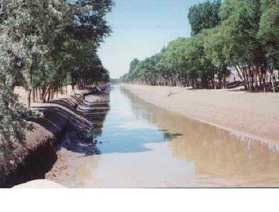
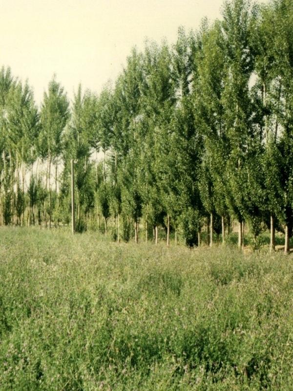
The shelter belt is a strip or a row of trees planted in a farmland as a wind barrier to protect crops and reduce wind erosion.
- ຜູ້ສັງລວມຂໍ້ມູນ: Meili WEN
2. ການອະທິບາຍ ເຕັກໂນໂລຢີ ຂອງການຄຸ້ມຄອງ ທີ່ດິນແບບຍືນຍົງ
2.1 ຄໍາອະທິບາຍສັ້ນຂອງ ເຕັກໂນໂລຢີ
ການກຳໜົດຄວາມໝາຍ ຂອງເຕັກໂນໂລຢີ:
Belts of trees, planted in a rectangular grid pattern or in strips within, and on the periphery of, farmland to act as windbreaks.
2.2 ການອະທິບາຍ ລາຍລະອຽດ ຂອງເຕັກໂນໂລຢີ
ການພັນລະນາ:
Shelterbelts to protect cropland are a specific type of agroforestry system comprising certain tall growing tree species. Such shelterbelts around farmland help reduce natural hazards including sandstorms, wind erosion, shifting sand, droughts and frost. They also improve the microclimate (reduced temperature, wind speed, soil water loss and excessive wind-induced transpiration) and create more favourable conditions for crop production. Thus the establishment of shelterbelts plays a crucial role in the sandy drylands that are affected by wind and resultant desertification
especially during winter and spring. Where there is irrigation, the shelterbelts protect the infrastructure from silting-up with wind-borne sediment.
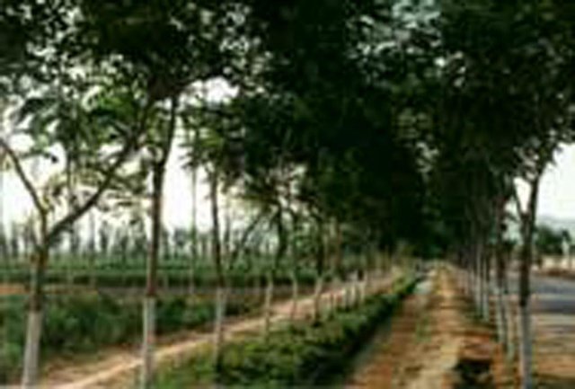
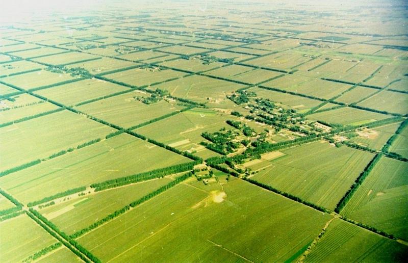
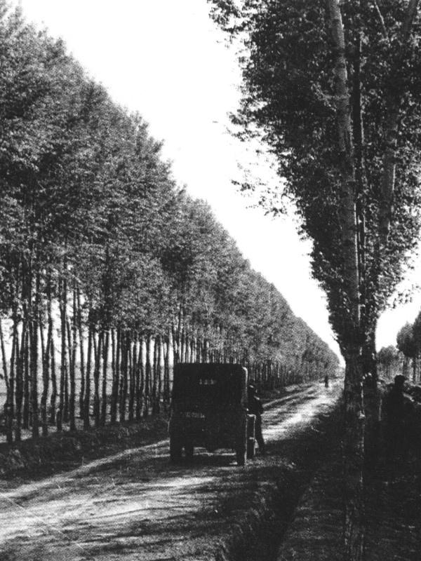
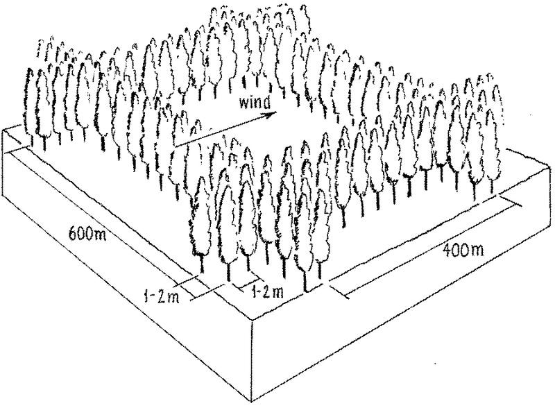
Strips of tall growing species (15-25 m) of poplar (Populus spp.) or willow (Salix spp.) were originally (from 1960s onwards) planted in a 400 by 600 m rectangular grid pattern within extensive areas of cropland, with an extra belt of windbreaks on the windward side (against the prevailing wind). Generally, the distance effectively protected is 15-25 times the tree height. Strips are of variable width, consisting of 2-5 tree lines (1-3 m apart) with trees planted every 1-2 m within the lines. Selective felling is used to maintain adequate growing space and the protective effect of the trees.
The impact of the shelterbelts depends on the planting pattern of the trees (the format of strips and grids), the orientation of the shelterbelts in relation to the wind, the spacing between, and the width of each strip and the type of trees planted. The specific design is primarily based on preventing the negative effects of wind, but depends also on local conditions such as the layout of the land, the location of the roads, farm boundaries and irrigation canals. Ideally the tree strips are perpendicular to the prevailing wind direction, and the angle between the strip and the prevailing wind is never less than 45 degrees. The structure of the strips determines the way the wind is controlled, ranging from blocking the wind
to letting it diffuse through semi-permeable shelterbelts. The best effect is achieved if the wind is not blocked entirely, as this can cause turbulence.
The ownership of the land and the shelterbelts still rests with the state, but management has been more and more transferred to individual households. On condition that the impact of the shelterbelt is not affected, the local forestry agencies now allow some felling of mature trees - on a rotational and selective basis, for timber and firewood. Pine trees (Pinus sylvestris var. mongolica and P. tabulaeformis), which command high value as timber for construction, and fruit (and cash) trees like the apricot tree (Prunus armeniace) are increasingly used.
2.3 ຮູບພາບຂອງເຕັກໂນໂລຢີ
ສື່ຮູບພາບ
2.5 ປະເທດ / ເຂດ / ສະຖານທີ່ບ່ອນທີ່ ເຕັກໂນໂລຢີ ໄດ້ຮັບການນໍາໃຊ້ ແລະ ທີ່ຖືກປົກຄຸມດ້ວຍການປະເມີນຜົນ
ປະເທດ:
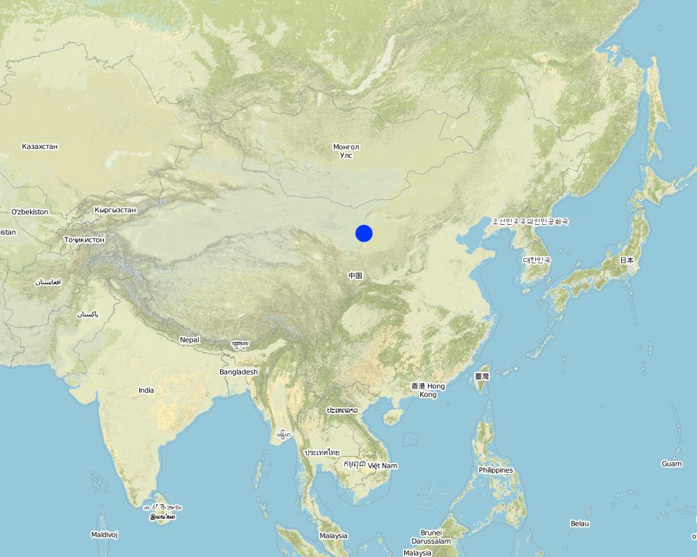
ຈີນ
ພາກພື້ນ / ລັດ / ແຂວງ:
Inner Mongolia Autonomous Region
ໃຫ້ລະບຸ ການແຜ່ຂະຫຍາຍ ເຕັກໂນໂລຢີ:
- ແຜ່ຂະຫຍາຍຢ່າງໄວວາໃນພື້ນທີ່
ຖ້າຫາກວ່າເຕັກໂນໂລຢີ ໄດ້ກະຈາຍໄປທົ່ວພື້ນທີ່, ໃຫ້ລະບຸເນື້ອທີ່ ທີ່ຖືກປົກຄຸມ (ເປັນ ກິໂລຕາແມັດ):
500.0
ຖ້າຫາກບໍ່ຮູ້ເນື້ອທີ່ທີ່ແນ່ນອນ, ໃຫ້ລະບຸ ເນື້ອທີ່ໂດຍປະມານ ທີ່ໃກ້ຄຽງ:
- 100-1,000 ກມ 2
ຄວາມຄິດເຫັນ:
Total area covered by the SLM Technology is 500 km2.
Total SWC Technology area is not clear. This technology area data is from Inner Mongolia forest department. Inner Mongolia autonomy region forest statistic data, 1987, P75. Technology beginning year is from: Water and soil conservation bureau, Yellow River irrigation works committee of Department of water and electricity. Water and soil conservation economy benefit thesis collecting,1987, P45-47.
Map
×2.6 ວັນທີໃນການຈັດຕັ້ງປະຕິບັດ
ຖ້າຫາກວ່າ ບໍ່ຮູ້ຈັກ ປີທີ່ຊັດເຈນ ແມ່ນໃຫ້ປະມານ ວັນທີເອົາ:
- ຫຼາຍກ່ອນ 50 ປີຜ່ານມາ (ແບບພື້ນບ້ານ)
2.7 ການນໍາສະເໜີ ເຕັກໂນໂລຢີ
ໃຫ້ລະບຸ ເຕັກໂນໂລຢີ ໄດ້ຖືກຈັດຕັ້ງປະຕິບັດຄືແນວໃດ?
- ໂດຍຜ່ານໂຄງການ / ການຊ່ວຍເຫຼືອຈາກພາຍນອກ
ຄວາມຄິດເຫັນ (ປະເພດ ໂຄງການ ແລະ ອື່ນໆ):
USA and domestic.
3. ການໃຈ້ແຍກ ເຕັກໂນໂລຢີ ໃນການຄຸ້ມຄອງ ດິນແບບຍືນຍົງ
3.1 ຈຸດປະສົງຫຼັກ (ຫຼາຍ) ຂອງເຕັກໂນໂລຢີ
- ຫຼຸດຜ່ອນຄວາມສ່ຽງ ທາງໄພພິບັດທໍາມະຊາດ
- ປັບຕົວຕໍ່ກັບການປ່ຽນແປງດິນຟ້າອາກາດ / ທີ່ຮ້າຍແຮງ ແລະ ຜົນກະທົບ
3.2 ປະເພດການນໍາໃຊ້ທີ່ດິນ ໃນປະຈຸບັນ() ທີ່ເຕັກໂນໂລຢີ ໄດ້ຖືກນໍາໃຊ້
ການນຳໃຊ້ທີ່ດິນ ປະສົມພາຍໃນພື້ນທີ່ດຽວກັນ:
ແມ່ນ
ລະບຸການນຳໃຊ້ທີ່ດິນແບບປະສົມ (ຜົນລະປູກ / ທົ່ງຫຍ້າລ້ຽງສັດ / ຕົ້ນໄມ້):
- ກະສິກໍາ-ປ່າໄມ້ ແບບປະສົມປະສານ

ດິນທີ່ປູກພືດ
- ການປູກພືດປະຈໍາປີ
ການປູກພືດປະຈຳປີ - ລະບຸປະເພດພືດ:
- ທັນຍາພືດ-ສາລີ
- wheat
ຈໍານວນ ລະດູການ ປູກໃນປີໜຶ່ງ:
- 1
ລະບຸ ຊະນິດ:
Longest growing period in days: 150Longest growing period from month to month: May - Sep

ປ່າໄມ້ / ປ່າ
- (ເຄິ່ງ) ປ່າໄມ້ທໍາມະຊາດ / ປ່າປູກໄມ້
- ການປູກຕົ້ນໄມ້, ການປູກປ່າ
(ເຄີ່ງ) ປ່າທໍາມະຊາດ / ປ່າປູກ: ລະບຸປະເພດການຄຸ້ມຄອງ:
- ການຄັດເລືອກຕັດ
ປະເພດຂອງຕົ້ນໄມ້:
- ສາຍພັນໝາກກໍ່
- Populus species
- Salix spp
ຜົນຜະລິດ ແລະ ການບໍລິການ:
- ເຄື່ອງປ່າຂອງດົງ
- ໄມ້ຟືນ
- ໝາກໄມ້ ແລະ ແກ່ນຖົ່ວ
- ປ້ອງກັນ ການຄຸກຄາມ ທາງທໍາມະຊາດ
ຄວາມຄິດເຫັນ:
Trees/ shrubs species: Poplars (Populus spp.), willows (Salix spp.), increasingly also pine (Pinus sylvestris var. Mongolic
Major land use problems (compiler’s opinion): Strong winds in the winter and spring result in serious natural hazards including sand storms, sand encroachment and wind erosion, while dry and hot winds in the summer increase transpiration leading to plant stress and reduced crop yields.
Major land use problems (land users’ perception): Low yield and intensive wind blow in winter and spring.
3.3 ການນຳໃຊ້ທີ່ດິນ ມີການປ່ຽນແປງຍ້ອນການຈັດຕັ້ງທົດລອງເຕັກໂນໂລຢີ ແມ່ນບໍ່?
ການນຳໃຊ້ທີ່ດິນ ມີການປ່ຽນແປງຍ້ອນການຈັດຕັ້ງທົດລອງເຕັກໂນໂລຢີ ແມ່ນບໍ່?
- ແມ່ນ (ກະລຸນາຕື່ມໃສ່ ຄຳຖາມຂ້າງລຸ່ມນີ້ກ່ຽວກັບການນຳໃຊ້ທີ່ດິນ ກ່ອນການທົດລອງເຕັກໂນໂລຢີ)
ດິນທີ່ປູກພືດ
- ການປູກພືດປະຈໍາປີ
3.4 ການສະໜອງນ້ຳ
ການສະໜອງນໍ້າ ໃນພື້ນທີ່ ທີ່ໄດ້ນໍາໃຊ້ ເຕັກໂນໂລຢີ:
- ປະສົມປະສານ ກັນລະຫວ່າງ ນໍ້າຝົນ ແລະ ນໍ້າຊົນລະປະທານ
3.5 ການນໍາໃຊ້ເຕັກໂນໂລຢີ ທີ່ຢູ່ໃນກຸ່ມການຄຸ້ມຄອງ ທີ່ດິນແບບຍືນຍົງ
- ກະສິກໍາ-ປ່າໄມ້ ແບບປະສົມປະສານ
- ແລວກັນລົມ / ພາຍຸ
3.6 ມາດຕະການ ການຄຸ້ມຄອງ ທີ່ດິນແບບຍືນຍົງ ປະກອບດ້ວຍ ເຕັກໂນໂລຢີ

ມາດຕະການ ທາງດ້ານພືດພັນ
- V1: ເປັນໄມ້ຢືນຕົ້ນ ແລະ ການປົກຫຸ້ມຂອງໄມ້ພຸ່ມ

ມາດຕະການ ທາງດ້ານການຄຸ້ມຄອງ
- M1: ການປ່ຽນແປງ ປະເພດ ການນໍາໃຊ້ທີ່ດິນ
ຄວາມຄິດເຫັນ:
Main measures: vegetative measures
Type of vegetative measures: aligned: -against wind
3.7 ປະເພດດິນເຊື່ອມໂຊມ ຫຼັກທີ່ໄດ້ນໍາໃຊ້ ເຕັກໂນໂລຢີ

ດິນເຊາະເຈື່ອນ ໂດຍລົມ
- ການສູນເສຍຊັ້ນໜ້າດິນ
- Eo: ຜົນກະທົບຈາກການເຊື່ອມໂຊມທາງອ້ອມ

ການເຊື່ອມໂຊມ ຂອງນໍ້າ
- Ha: ສະພາບແຫ້ງແລ້ງ
ຄວາມຄິດເຫັນ:
Main type of degradation addressed: Et: loss of topsoil, Eo: offsite degradation effects, Ha: aridification
Main causes of degradation: deforestation / removal of natural vegetation (incl. forest fires), poverty / wealth (Lack of captial)
Secondary causes of degradation: overgrazing, education, access to knowledge and support services (Lack of knowledge), Lack of enforcement of legislat./authority
3.8 ການປ້ອງກັນ, ການຫຼຸດຜ່ອນ, ຫຼືການຟື້ນຟູຂອງການເຊື່ອມໂຊມຂອງດິນ
ໃຫ້ລະບຸ ເປົ້າໝາຍ ເຕັກໂນໂລຢີ ທີ່ພົວພັນ ກັບຄວາມເຊື່ອມໂຊມຂອງດິນ:
- ຫຼຸດຜ່ອນການເຊື່ອມໂຊມຂອງດິນ
ຄວາມຄິດເຫັນ:
Main goals: mitigation / reduction of land degradation
4. ຂໍ້ກໍາໜົດ, ກິດຈະກໍາການປະຕິບັດ, ວັດຖຸດິບ, ແລະຄ່າໃຊ້ຈ່າຍ
4.1 ເຕັກນິກ ໃນການແຕ້ມແຜນວາດ ເຕັກໂນໂລຢີ
ຄຸນລັກສະນະ ຂອງເຕັກນິກ (ທີ່ກ່ຽວຂ້ອງ ກັບການແຕ້ມແຜນວາດ ທາງດ້ານເຕັກນີກ):
Overview of the shelterbelt layout.
Insert 1: Planting scheme: shelterbelts compromise 2-5 tree lines forming the windbreak about 5-15 m wide and 15-25 m high.
Insert 2: Rectangle grid layout of shelterbelts. Spacing of the rows is denser against the prevailing wind.
Technical knowledge required for field staff / advisors: moderate
Technical knowledge required for land users: low
Main technical functions: increase / maintain water stored in soil, reduction in wind speed, protection from wind erosion, protection from sand encroachment, protection of crops from mechanical damage, reduction in evaporation loss
Secondary technical functions: increase in organic matter
Aligned: -against wind
Vegetative material: T : trees / shrubs
Trees/ shrubs species: Poplars (Populus spp.), willows (Salix spp.), increasingly also pine (Pinus sylvestris var. Mongolic)
ຜູ້ຂຽນ:
Mats Gurtner
4.2 ຂໍ້ມູນທົ່ວໄປກ່ຽວກັບການຄິດໄລ່ປັດໃຈຂາເຂົ້າໃນການຜະລິດ ແລະ ມູນຄ່າອື່ນໆ
ລະບຸ ວິທີການ ຄຳໃຊ້ຈ່າຍ ແລະ ປັດໄຈນໍາເຂົ້າ ທີ່ໄດ້ຄິດໄລ່:
- ຕໍ່ພື້ນທີ່ ທີ່ໄດ້ຈັດຕັ້ງປະຕິບັດ ເຕັກໂນໂລຢີ
ໃຫ້ລະບຸຫົວໜ່ວຍ ຂະໜາດ ແລະ ເນື້ອທີ່:
ha
ລະບຸ ສະກຸນເງິນທີ່ໃຊ້ສໍາລັບ ການຄິດໄລ່ຄ່າໃຊ້ຈ່າຍ:
- USA
ລະບຸ ຄ່າຈ້າງ ຄ່າແຮງງານສະເລ່ຍ ຕໍ່ ວັນ:
1.20
4.3 ການສ້າງຕັ້ງກິດຈະກໍາ
| ກິດຈະກໍາ | Timing (season) | |
|---|---|---|
| 1. | 1 Planning / designing of shelterbelt. | |
| 2. | 2 Selection and collection of trees seedlings. | |
| 3. | 3 Clearing and preparing land for planting of shelterbelt in | late autumn and spring |
| 4. | 3 Clearing and preparing land for planting of shelterbelt in | |
| 5. | 4 Pits for planting the seedlings are dug | 4 Pits for planting the seedlings are dug |
| 6. | 5 Tree seedlings are planted | late spring |
| 7. | 6 After planting each seedling is watered for up to two years. |
4.4 ຕົ້ນທຶນ ແລະ ປັດໄຈຂາເຂົ້າທີ່ຈໍາເປັນໃນຈັດຕັ້ງປະຕິບັດ
| ລະບຸ ປັດໃຈ ນໍາເຂົ້າ ໃນການຜະລີດ | ຫົວໜ່ວຍ | ປະລິມານ | ຕົ້ນທຶນ ຕໍ່ຫົວໜ່ວຍ | ຕົ້ນທຶນທັງໝົດ ຂອງປັດໃຈຂາເຂົ້າ ໃນການຜະລິດ | % ຂອງຕົ້ນທຶນທັງໝົດ ທີ່ຜູ້ນໍາໃຊ້ທີ່ດິນ ໃຊ້ຈ່າຍເອງ | |
|---|---|---|---|---|---|---|
| ແຮງງານ | Mainly collection and planting | ha | 79.0 | 1.2 | 94.8 | |
| ອຸປະກອນ | tools | ha | 1.0 | 5.0 | 5.0 | 100.0 |
| ວັດສະດຸໃນການປູກ | tree seedlings | ha | 1.0 | 25.0 | 25.0 | |
| ຕົ້ນທຶນທັງໝົດ ໃນການຈັດຕັ້ງປະຕິບັດ ເຕັກໂນໂລຢີ | 124.8 | |||||
| ຄ່າໃຊ້ຈ່າຍທັງໝົດ ສຳລັບການສ້າງຕັ້ງເຕັກໂນໂລຢີ ເປັນສະກຸນເງີນໂດລາ | 124.8 | |||||
ຖ້າຫາກຜູ້ນຳໃຊ້ທີ່ດິນ ນຳໃຊ້ມູນຄ່າຕ່ຳກວ່າ 100% ໃຫ້ລະບຸ ແມ່ນໃຜເປັນຜູ້ຊ່ວຍ ໃນລາຍຈ່າຍທີ່ເຫຼືອ:
USA and domestic projects
ຄວາມຄິດເຫັນ:
Duration of establishment phase: 36 month(s)
4.5 ບໍາລຸງຮັກສາ / ແຜນຈັດຕັ້ງປະຕິບັດ ກິດຈະກໍາ
| ກິດຈະກໍາ | ໄລຍະເວລາ / ຄວາມຖີ່ | |
|---|---|---|
| 1. | Watering | after planting /timely |
| 2. | Pruning of trees. | |
| 3. | Pest and disease control within shelterbelt. | |
| 4. | Intermediate/ selective tree felling. |
4.6 ຄ່າໃຊ້ຈ່າຍ ແລະ ປັດໄຈນໍາເຂົ້າທີ່ຈໍາເປັນສໍາລັບການບໍາລຸງຮັກສາກິດຈະກໍາ / ແຜນປະຕິບັດ (ຕໍ່ປີ)
| ລະບຸ ປັດໃຈ ນໍາເຂົ້າ ໃນການຜະລີດ | ຫົວໜ່ວຍ | ປະລິມານ | ຕົ້ນທຶນ ຕໍ່ຫົວໜ່ວຍ | ຕົ້ນທຶນທັງໝົດ ຂອງປັດໃຈຂາເຂົ້າ ໃນການຜະລິດ | % ຂອງຕົ້ນທຶນທັງໝົດ ທີ່ຜູ້ນໍາໃຊ້ທີ່ດິນ ໃຊ້ຈ່າຍເອງ | |
|---|---|---|---|---|---|---|
| ແຮງງານ | Watering and Pruning | ha | 7.0 | 1.2 | 8.4 | 100.0 |
| ວັດສະດຸໃນການປູກ | tree seedling | ha | 1.0 | 3.0 | 3.0 | 100.0 |
| ຕົ້ນທຶນທັງໝົດ ທີ່ໃຊ້ໃນການບໍາລຸງຮັກສາ ເຕັກໂນໂລຢີ | 11.4 | |||||
| ຄ່າໃຊ້ຈ່າຍທັງໝົດ ສຳລັບການບົວລະບັດຮກສາເຕັກໂນໂລຢີ ເປັນສະກຸນເງີນໂດລາ | 11.4 | |||||
ຄວາມຄິດເຫັນ:
The costs are calculated according to current standards/costs. The original planting is paid for by the state: replanting
and maintenance are the responsibility of the land user. If pines are the species of choice for re-planting, the cost
is considerably more than that shown above (which relates to poplar and willow).
Assuming: shelterbelts of 600 m by 400 m; each strip has 5 lines of trees (3 m apart), 2 m between trees within lines: resulting in 104 trees/ha, including the cropland between the strips (density within strips is 1666 trees/ha). Labour for establishment (104 trees): Land preparation, planting 10 days and 15 days for watering, weeding, etc (for first 3 years).
4.7 ປັດໄຈ ທີ່ສໍາຄັນ ທີ່ສົ່ງຜົນກະທົບ ຕໍ່ຄ່າໃຊ້ຈ່າຍ
ໃຫ້ອະທິບາຍ ປັດໃຈ ທີ່ສົ່ງຜົນກະທົບ ຕໍ່ຕົ້ນທຶນ ໃນການຈັດຕັ້ງປະຕິບັດ:
The most important factors to affect the costs are seedlings (No.) and machine.
5. ສະພາບແວດລ້ອມທໍາມະຊາດ ແລະ ມະນຸດ
5.1 ອາກາດ
ປະລິມານນໍ້າຝົນປະຈໍາປີ
- < 250 ມີລິແມັດ
- 251-500 ມີລິແມັດ
- 501-750 ມີລິແມັດ
- 751-1,000 ມີລິແມັດ
- 1,001-1,500 ມີລິແມັດ
- 1,501-2,000 ມີລິແມັດ
- 2,001-3,000 ມີລິແມັດ
- 3,001-4,000 ມີລິແມັດ
- > 4,000 ມີລິແມັດ
ໃຫ້ລະບຸສະເລ່ຍ ປະລິມານນໍ້າຝົນຕົກປະຈໍາປີ ເປັນມິນລິແມັດ (ຖ້າຫາກຮູ້ຈັກ):
430.00
ເຂດສະພາບອາກາດກະສິກໍາ
- ເຄິ່ງແຫ້ງແລ້ງ
5.2 ພູມິປະເທດ
ຄ່າສະເລ່ຍ ຄວາມຄ້ອຍຊັນ:
- ພື້ນທີ່ຮາບພຽງ (0-2%)
- ອ່ອນ (3-5 %)
- ປານກາງ (6-10 %)
- ມ້ວນ (11-15 %)
- ເນີນ(16-30%)
- ໍຊັນ (31-60%)
- ຊັນຫຼາຍ (>60%)
ຮູບແບບຂອງດິນ:
- ພູພຽງ / ທົ່ງພຽງ
- ສັນພູ
- ເປີ້ນພູ
- ເນີນພູ
- ຕີນພູ
- ຮ່ອມພູ
ເຂດລະດັບສູງ:
- 0-100 ແມັດ a.s.l.
- 101-500 ແມັດ a.s.l.
- 501-1,000 ແມັດ a.s.l.
- 1,001-1,500 ແມັດ a.s.l.
- 1,501-2,000 ແມັດ a.s.l.
- 2,001-2,500 ແມັດ a.s.l.
- 2,501-3,000 ແມັດ a.s.l.
- 3,001-4,000 ແມັດ a.s.l.
- > 4,000 ແມັດ a.s.l.
ໃຫ້ລະບຸ ເຕັກໂນໂລຢີ ທີ່ໄດ້ຖືກນຳໃຊ້:
- ບໍ່ກ່ຽວຂ້ອງ
5.3 ດິນ
ຄວາມເລິກ ຂອງດິນສະເລ່ຍ:
- ຕື້ນຫຼາຍ (0-20 ຊັງຕີແມັດ)
- ຕື້ນ (21-50 ຊຕມ)
- ເລີກປານກາງ (51-80 ຊຕມ)
- ເລິກ (81-120 ຊມ)
- ເລິກຫຼາຍ (> 120 cm)
ເນື້ອດິນ (ໜ້າດິນ):
- ຫຍາບ / ເບົາ (ດິນຊາຍ)
ຊັ້ນອິນຊີວັດຖຸ ເທິງໜ້າດິນ:
- ປານກາງ (1-3 %)
ຖ້າເປັນໄປໄດ້ ແມ່ນໃຫ້ຕິດຄັດ ການພັນລະນາດິນ ຫຼື ຂໍ້ມູນສະເພາະຂອງດິນ, ຕົວຢ່າງ, ຄຸນລັກສະນະ ປະເພດຂອງດິນ, ຄ່າຄວາມເປັນກົດ / ເປັນດ່າງຂອງດິນ, ສານອາຫານ, ດິນເຄັມ ແລະ ອື່ນໆ.
Soil fertility: low -medium
Soil drainage / infiltration: good
Soil water storage capacity: medium
5.6 ຄຸນລັກສະນະ ຂອງຜູ້ນໍາໃຊ້ທີ່ດິນ ທີ່ໄດ້ນໍາໃຊ້ເຕັກໂນໂລຢີ
ລະບົບ ການຕະຫຼາດ ແລະ ຜົນຜະລິດ:
- ປະສົມປົນເປ( ກຸ້ມຕົນເອງ/ເປັນສິນຄ້າ)
ລາຍຮັບ ທີ່ບໍ່ໄດ້ມາຈາກ ການຜະລິດ ກະສິກໍາ:
- 10-50 % ຂອງລາຍຮັບທັງໝົດ
ລະດັບຄວາມຮັ່ງມີ:
- ສະເລ່ຍ
ລະດັບ ການຫັນເປັນກົນຈັກ:
- ເຄື່ອງກົນຈັກ
ໃຫ້ລະບຸ ຄຸນລັກສະນະ ຂອງຜູ້ນໍາໃຊ້ທີ່ດິນ:
Population density: 10-50 persons/km2
Annual population growth: 1% - 2%
80% of the land users are average wealthy and own 35% of the land.
Off-farm income specification: farmers benefit from the shelterbelts as a source of off-farm income, through fodder, timber and firewood
5.7 ເນື້ອທີ່ສະເລ່ຍຂອງດິນ ທີ່ຜູ້ນຳໃຊ້ທີ່ດິນ ໃຊ້ເຮັດເຕັກໂນໂລຢີ
- <0.5 ເຮັກຕາ
- 0.5-1 ເຮັກຕາ
- 1-2 ເຮັກຕາ
- 2-5 ເຮັກຕາ
- 5-15 ເຮັກຕາ
- 15-50 ເຮັກຕາ
- 50-100 ເຮັກຕາ
- 100-500 ເຮັກຕາ
- 500-1,000 ເຮັກຕາ
- 1,000-10,000 ເຮັກຕາ
- > 10,000 ເຮັກຕາ
5.8 ເຈົ້າຂອງທີ່ດິນ, ສິດໃຊ້ທີ່ດິນ, ແລະ ສິດທິການນໍາໃຊ້ນໍ້າ
- communal/state
- individual (see Annex T3 for remark)
- individual (see Annex T3 for remark)
6. ຜົນກະທົບ ແລະ ລາຍງານສະຫຼຸບ
6.1 ການສະແດງຜົນກະທົບ ພາຍໃນພື້ນທີ່ ທີ່ໄດ້ຈັດຕັ້ງປະຕິບັດ ເຕັກໂນໂລຢີ
ຜົນກະທົບທາງເສດຖະກິດສັງຄົມ
ການຜະລິດ
ການຜະລິດພືດ
ຜົນຜະລິດໄມ້
ເນື້ອທີ່ການຜະລິດ
ຄວາມຄິດເຫັນ / ລະບຸແຈ້ງ:
width of the shelterbelt
ລາຍໄດ້ ແລະ ຄ່າໃຊ້ຈ່າຍ
ລາຍຮັບ ຈາກການຜະລີດ
ຜົນກະທົບທາງດ້ານເສດຖະກິດສັງຄົມອື່ນໆ
off-farm income
ຄວາມຄິດເຫັນ / ລະບຸແຈ້ງ:
extra timber and firewood
Crop production
ຄວາມຄິດເຫັນ / ລະບຸແຈ້ງ:
Trees in competition with crops for solar radiation, fertilizer, and water
ຜົນກະທົບດ້ານວັດທະນາທໍາສັງຄົມ
ການຫຼຸດຜ່ອນ ຂໍ້ຂັດແຍ່ງ
Loss of Food per agricultural land
ຄວາມຄິດເຫັນ / ລະບຸແຈ້ງ:
shelterbelts of trees are not a direct source of food
ຜົນກະທົບຕໍ່ລະບົບນິເວດ
ວົງຈອນນໍ້າ / ນໍ້າ
ການໄຫຼ ຂອງນໍ້າໜ້າດິນ
ປະລິມານ ກ່ອນການຈັດຕັ້ງປະຕິບັດ ການຄຸ້ມຄອງ ທີ່ດິນແບບຍືນຍົງ:
8
ປະລີມານ ຫຼັງການຈັດຕັ້ງປະຕິບັດ ການຄຸ້ມຄອງ ທີ່ດິນແບບຍືນຍົງ:
0
ດິນ
ຄວາມຊຸ່ມຂອງດິນ
ການປົກຄຸມຂອງດິນ
ການສູນເສຍດິນ
ປະລິມານ ກ່ອນການຈັດຕັ້ງປະຕິບັດ ການຄຸ້ມຄອງ ທີ່ດິນແບບຍືນຍົງ:
4
ປະລີມານ ຫຼັງການຈັດຕັ້ງປະຕິບັດ ການຄຸ້ມຄອງ ທີ່ດິນແບບຍືນຍົງ:
2
ການຫຼຸດຜ່ອນ ຄວາມສ່ຽງ ຈາກໄພພິບັດ ແລະ ອາກາດປ່ຽນແປງ
ຄວາມຮູນແຮງ ຂອງລົມ
ຜົນກະທົບຕໍ່ລະບົບນິເວດອື່ນໆ
sand encroachment
microclimate for crops
ຄວາມຄິດເຫັນ / ລະບຸແຈ້ງ:
regulating temperature, increasing humidity
conservation/maintenance of soil fertility
6.4 ການວິເຄາະຕົ້ນທຶນ ແລະ ຜົນປະໂຫຍດ
ຈະໄດ້ຮັບຜົນປະໂຫຍດເມື່ອປຽບທຽບກັບ / ຄ່າໃຊ້ຈ່າຍໃນການບຳລຸງຮັກສາທີເ່ກີດຂື້ນອິກ (ຈາກທັດສະນະຄະຕິຂອງຜູ້ນຳໃຊ້ທີ່ດິນ) ໄດ້ແນວໃດ?
ຜົນຕອບແທນ ໃນໄລຍະສັ້ນ:
ຜົນກະທົບທາງບວກເລັກນ້ອຍ
ຜົນຕອບແທນ ໃນໄລຍະຍາວ:
ຜົນກະທົບທາງບວກຫຼາຍ
6.5 ການປັບຕົວຮັບເອົາເຕັກໂນໂລຢີ
- ກໍລະນີດຽວ / ການທົດລອງ
ຖ້າຫາກວ່າມີ, ປະລິມານ (ຈໍານວນຂອງຄົວເຮືອນ / ເນື້ອທີ່ການຄຸ້ມຄອງ):
40 households in an area of 100-1000km^2 (10-50 persons/km^2)
ທັງໝົດນັ້ນ ແມ່ນໃຜ ໄດ້ປັບຕົວເຂົ້າ ໃນການນໍາໃຊ້ ເຕັກໂນໂລຢີ, ມີຈັກຄົນ ທີ່ສາມາດເຮັດເອງໄດ້, ຕົວຢ່າງ, ປາດສະຈາກ ການຊ່ວຍເຫຼືອ ທາງດ້ານອຸປະກອນ / ການຈ່າຍເປັນເງິນ?
- 0-10%
ຄວາມຄິດເຫັນ:
100% of land user families have adopted the Technology with external material support
40 land user families have adopted the Technology with external material support
Comments on acceptance with external material support: estimates
Comments on spontaneous adoption: estimates
There is no trend towards spontaneous adoption of the Technology
Comments on adoption trend: The technology has not spontaneously spread beyond the areas developed through government intervention.
6.7 ຈຸດແຂງ / ຂໍ້ດີ / ໂອກາດ ໃນການນໍາໃຊ້ ເຕັກໂນໂລຢີ
| ຈຸດແຂງ / ຈຸດດີ / ໂອກາດ ຈາກທັດສະນະຂອງຜູ້ປ້ອນຂໍ້ມູນ ຫຼື ບຸກຄົນສຳຄັນ |
|---|
|
Reduced wind speed and trapped wind-blown sand particle How can they be sustained / enhanced? Combine deciduous and evergreen trees to maintain shelterbelt’s protective function throughtout the year. |
|
Increased crop yield How can they be sustained / enhanced? Extend shelterbelt technology to unprotected croplands. |
|
Increased cash income How can they be sustained / enhanced? Improve rotational felling regimes that maximise quantity and quality of tree products (timber; fruit etc) without reducing the shelterbelt’s protective function. In Inner Mongolia apricot (Prunus armeniaca) and sea buckthorn (Hippophae rhamnoides) and in Gansu Province the Chinese dates (Ziziphus jujuba) are increasingly used. |
|
Apart from their effect on the wind, the overall benefits of the shelterbelts - for timber, firewood, fruits and fodder for animals - outweigh the loss of cropland occupied by trees How can they be sustained / enhanced? Experience over 40 years has demonstrated that narrower trees strips and smaller grid size (100 by 200 m) would increase ecological efficiency, but due to higher costs and potential competition with crops, the spacing of the shelterbelts has mostly remained as it was originally. |
|
From 1960 onwards, approximately 22 million hectares – of vulnerable cropland have been protected in eastern Inner Mongolia Editors’ comments: In China, a total of 1.84 million km2 suffer from desertification related to sand storms, shifting sands and wind erosion, making up 19% of the total land area. In those dry and desertified zones, farmland is barely productive, even with irrigation. The construction of shelterbelts in this northeastern part of China has had multiple benefits that outweigh the loss of cropland. However, maintenance has become an important issue with the changes in China’s land use laws. This is one of two examples of windbreaks amongst the case studies in this book. Remark: In the 1960s, all land ownership and land use rights in China were communal and cropland was farmed collectively by village communes. After reform and open policy was put into practice in 1978, land use rights were transferred to the villages, to groups and individuals. Land itself and the shelterbelts however still belonged to the state. Nowadays the rights to cultivate specific parcels of land, within protected blocks, are generally granted to individual farm households. In some cases, in recent years, the shelterbelts too have been redistributed to individuals to look after. Inevitably maintenance has become an issue. But most of the shelterbelts are managed well. 3.2.8: If farmer cuts mature timber (for example a 40 year-old poplar), he/she can sell it for US$ 20–25 per tree. With maturity of shelterbelts, the timber production increases, which brings increasing economic benefits; meanwhile, the effect of protection from wind erosion also improves. |
6.8 ຈຸດອ່ອນ / ຂໍ້ເສຍ / ຄວາມສ່ຽງ ໃນການນໍາໃຊ້ ເຕັກໂນໂລຢີ ແລະ ວິທີການແກ້ໄຂບັນຫາ
| ຈຸດອ່ອນ/ຂໍ້ບົກຜ່ອງ/ຄວາມສ່ຽງ ຈາກທັດສະນະຂອງຜູ້ປ້ອນຂໍ້ມູນ ຫຼື ບຸກຄົນສຳຄັນ | ມີວິທີການແກ້ໄຂຄືແນວໃດ? |
|---|---|
| Loss of land due to area used for the shelterbelts | In this wind-prone part of Inner Mongolia, overall gains from the protected zones compensate for the reduced area under crops, especially if economically valuable species are planted in the shelterbelt, such as Caragana korshinskii, which can be used as forage, for 'green fertilizer' through leaf mulch and for firewood. |
| Competition for sunshine, fertilizer and water | Pruning of branches and digging of ditches to prevent roots penetrating the adjacent cropland |
| Farmers lost the right to crop the tree-occupied land (since the shelterbelts belonged to the state). Originally, farmers were not allowed to fell trees | Nowadays the local forestry department permits farmers to occasionally cut trees, which is a source of income. If land users were allowed to cut trees on a more systematic basis, it would help them to better appreciate the benefits. |
| High cost (labour and money) for establishment | Government support required. |
|
Shelterbelts comprised of single tree species are less resistant to pests and diseases Shelterbelts consume more water |
Combine trees and shrubs/ different species, which improves both resistance and also the protective effect. But they also help in drainage (where this is a problem) through lowering the ground water table and simultaneously reducing salinity. Appropriate tree species need to be selected and bred. |
7. ເອກະສານອ້າງອີງ ແລະ ການເຊື່ອມຕໍ່
7.1 ວິທີການ / ແຫຼ່ງຂໍ້ມູນ
7.2 ເອກກະສານອ້າງອີງທີ່ເປັນບົດລາຍງານ
ຫົວຂໍ້, ຜູ້ຂຽນ, ປີ, ISBN:
China atlas. China atlas publishing house, P 52.. 1999.
ມີຢູ່ໃສ?ມູນຄ່າເທົ່າໃດ?
library of Department of Resource and Environmental Science, BNU.
ຫົວຂໍ້, ຜູ້ຂຽນ, ປີ, ISBN:
Zhao Yu, Jing Zhengping, Shi Peijun, Hao Yunchong et al. Inner Mongolia soil erosion research remote sensing was used in Inner Mongolia soil erosion research, Science publishing house, P25.. 1989.
ມີຢູ່ໃສ?ມູນຄ່າເທົ່າໃດ?
library of Department of Resource and Environmental Science, BNU.
ຫົວຂໍ້, ຜູ້ຂຽນ, ປີ, ISBN:
Inner Mongolia forest department, Forest work manual,12, P33-34, P67.. 1998.
ມີຢູ່ໃສ?ມູນຄ່າເທົ່າໃດ?
library of Department of Resource and Environmental Science, BNU.
ຫົວຂໍ້, ຜູ້ຂຽນ, ປີ, ISBN:
Synthesized investigate team in Inner Mongolia-Ningxia, CAS. West of northeast Forest in Inner Mongolia autonomy region, Science publishing house, P82-101.. 1981.
ມີຢູ່ໃສ?ມູນຄ່າເທົ່າໃດ?
library of Department of Resource and Environmental Science, BNU.
ຫົວຂໍ້, ຜູ້ຂຽນ, ປີ, ISBN:
Sun Jinzhu. Natural condition and reconstruct in Hetao plain, Inner Mongolia people' s publishing house, P188-189.. 1976.
ມີຢູ່ໃສ?ມູນຄ່າເທົ່າໃດ?
library of Department of Resource and Environmental Science, BNU.
ຫົວຂໍ້, ຜູ້ຂຽນ, ປີ, ISBN:
Inner Mongolia forest Department. Inner Mongolia autonomy region forest statistic data,P75.. 1987.
ມີຢູ່ໃສ?ມູນຄ່າເທົ່າໃດ?
library of Department of Resource and Environmental Science, BNU.
ຫົວຂໍ້, ຜູ້ຂຽນ, ປີ, ISBN:
Hu Chun(chief editor). Inner Mongolia autonomy region climate resources about agriculture, forest and animal husbandry, Inner Mongolia people's publishing house, P45-47.. 1984.
ມີຢູ່ໃສ?ມູນຄ່າເທົ່າໃດ?
library of Department of Resource and Environmental Science, BNU.
ຫົວຂໍ້, ຜູ້ຂຽນ, ປີ, ISBN:
Water and soil conservation bureau, Yellow River irrigation works committee of Department of water and electricity. Water and soil conservation economy benefit thesis collecting, P45-47.. 1987.
ມີຢູ່ໃສ?ມູນຄ່າເທົ່າໃດ?
library of Department of Resource and Environmental Science, BNU.
ຫົວຂໍ້, ຜູ້ຂຽນ, ປີ, ISBN:
Zhang Pangchuen, A study on the benefit of shelter belt in the south part of Kerqin sand to agriculture increase in production. Journal of arid land resource and environment. Vol.4, no.1, P11-87.. 1990.
ມີຢູ່ໃສ?ມູນຄ່າເທົ່າໃດ?
library of Department of Resource and Environmental Science, BNU.
ຫົວຂໍ້, ຜູ້ຂຽນ, ປີ, ISBN:
Sun Jinzhu,Chen Shan(chief editor). Inner Mongolia environment alarm beforehand and repair countermeasure. Inner Mongolia people's publishing house, P132.. 1994.
ມີຢູ່ໃສ?ມູນຄ່າເທົ່າໃດ?
library of Department of Resource and Environmental Science, BNU.
ຫົວຂໍ້, ຜູ້ຂຽນ, ປີ, ISBN:
Compilation Committee of Inner Mongolia Forest Inner Mongolia Forest, Beijing: China Forestry Publishing House, 1989,299–319. 1989.
ຂໍ້ມູນການເຊື່ອມຕໍ່ ແລະ ເນື້ອໃນ
ຂະຫຍາຍທັງໝົດ ຍຸບທັງໝົດການເຊື່ອມຕໍ່
Shelter Belt [ຈີນ]
The shelter belt is a strip or a row of trees planted in a farmland as a wind barrier to protect crops and reduce wind erosion.
- ຜູ້ສັງລວມຂໍ້ມູນ: Meili WEN
ເນື້ອໃນ
ບໍ່ມີເນື້ອໃນ