Shrubbery buffer strip with bund [ຈີນ]
- ການສ້າງ:
- ປັບປູງ:
- ຜູ້ສັງລວມຂໍ້ມູນ: Mei Zhao
- ບັນນາທິການ: –
- ຜູ້ທົບທວນຄືນ: David Streiff, Alexandra Gavilano
Grass Buffer Strip
technologies_1544 - ຈີນ
ເບິ່ງພາກສ່ວນ
ຂະຫຍາຍທັງໝົດ ຍຸບທັງໝົດ1. ຂໍ້ມູນທົ່ວໄປ
1.2 ຂໍ້ມູນ ການຕິດຕໍ່ພົວພັນ ຂອງບຸກຄົນທີ່ສໍາຄັນ ແລະ ສະຖາບັນ ທີ່ມີສ່ວນຮ່ວມ ໃນການປະເມີນເອກກະສານ ເຕັກໂນໂລຢີ
ຜຸ້ຊ່ຽວຊານ ດ້ານການຄຸ້ມຄອງ ທີ່ດິນແບບຍືນຍົງ:
1.3 ເງື່ອນໄຂ ກ່ຽວກັບ ການນໍາໃຊ້ຂໍ້ມູນເອກະສານ ທີ່ສ້າງຂື້ນ ໂດຍຜ່ານ ອົງການພາບລວມຂອງໂລກ ທາງດ້ານແນວທາງ ແລະ ເຕັກໂນໂລຢີ ຂອງການອານຸລັກ ທໍາມະຊາດ (WOCAT)
ຜູ້ປ້ອນຂໍ້ມູນ ແລະ ບຸກຄົນສຳຄັນ ທີ່ໃຫ້ຂໍ້ມູນ (ຫຼາຍ) ຍິນຍອມ ຕາມເງື່ອນໄຂ ໃນການນຳໃຊ້ຂໍ້ມູນ ເພື່ອສ້າງເປັນເອກກະສານຂອງ WOCAT:
ແມ່ນ
2. ການອະທິບາຍ ເຕັກໂນໂລຢີ ຂອງການຄຸ້ມຄອງ ທີ່ດິນແບບຍືນຍົງ
2.1 ຄໍາອະທິບາຍສັ້ນຂອງ ເຕັກໂນໂລຢີ
ການກຳໜົດຄວາມໝາຍ ຂອງເຕັກໂນໂລຢີ:
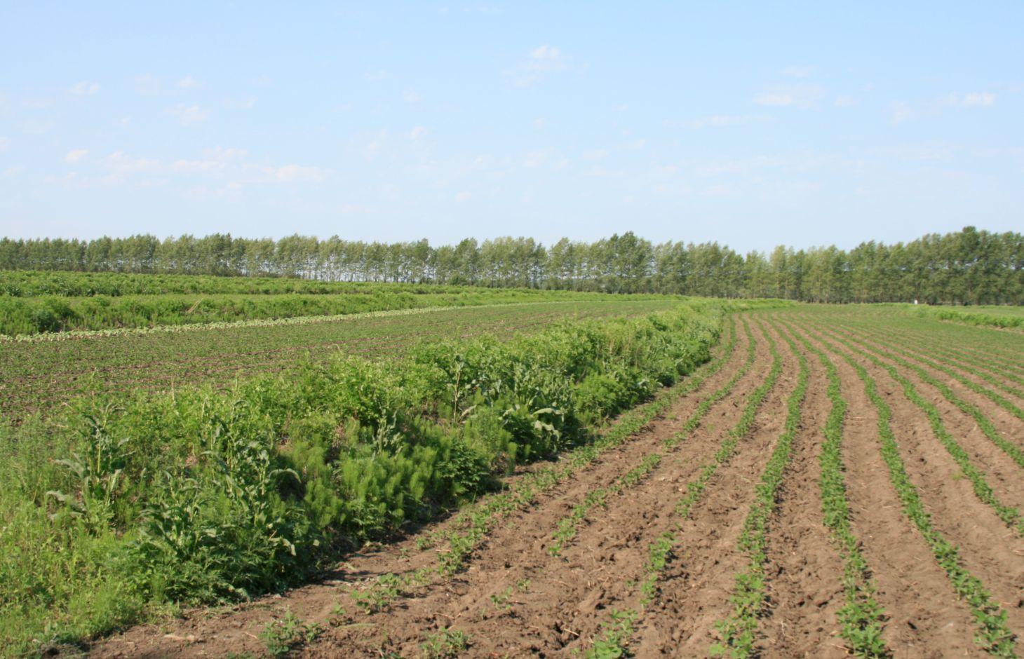
Belts of shrub or grass, planted on the level bund which constructed along contour line in gentle slope farmland in the black soil region of Northeast China.
2.2 ການອະທິບາຍ ລາຍລະອຽດ ຂອງເຕັກໂນໂລຢີ
ການພັນລະນາ:
Shrubbery buffer strip with bund(SBSWB) is a traditional technology, it is introduced by the field staff about 60 years ago who worked in the farm in Heilongjiang province.This technology with low-cost, high effectives and easy to construct, which has been widely applied in all black soil region of Northeast China (Heilongjiang,Jilin,Liaoning,North of Inner Mongolia Autonomous Region).
Purpose of the Technology: The final purpose of these buffer strips is increasing crop production by decreasing soil loss. More specific objectives include: 1)protect the land from surface erosion by cutting slope length, increase infiltration and soil moisture; 2)to prevent soil loss of gentle slope farmland by allowing excess runoff to filter through but trapping sediment; 3) through the effect of tillage and water erosion between the strips, level bund lead to the formation of forward slope terraces over time, then developing into terrace final;4) creation of opportunities for additional income by harvesting fodder(grass) production and fruits(shrub).
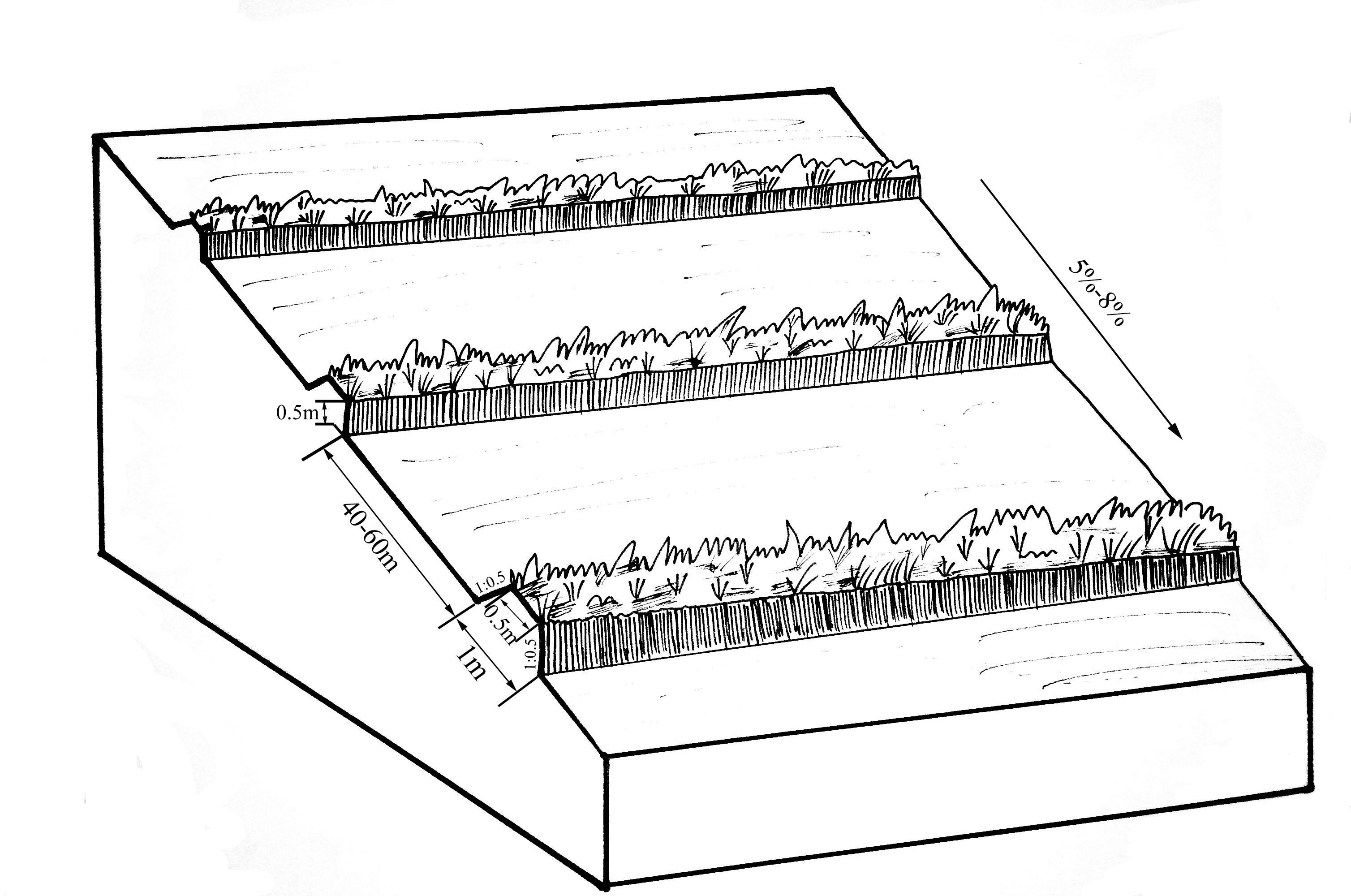
Establishment / maintenance activities and inputs: A construction is generally carried out in autumn of the year; plantation is made in spring of the next year. The construction in a man-machine integration mode is generally carried out step by step and from top to bottom along the contour line(s). The ladder-shaped cross section of a ridge is 0.3-0.5m in width (suitable width on the top), 0.5-0.6m in height, 1:1 or 1:0.5 in inner-side gradient and 1:0.5 in outer-side gradient.
In a construction, peel the surface soil with machine, with the peeling depth generally being 0.3m, which should be subject to soil layer depth; then haul the ridge construction plough (a kind of machine or device) with a tractor to build the ridges, consolidate the ridges through artificial slapping; Finally restore the surface soil to accomplish ridge construction. The tops of the constructed ridges should be maintained to be in a horizontal surface. The distance between two ridges in this region is generally stipulated to be 50 meters. The soil for ridge construction should be free from such sundries as gravels, tree roots and turfs.
Natural / human environment: Shrubbery buffer strip is found mainly in Northeast China, at altitudes between 700 and 1600 m. Climate there is cold in winters and cool in summers, with a monsoon moisture regime. In the area, the annual mean temperatures is from 2 to 8 °C, and the annual mean precipitation is from 500 to 1000 mm. Most of the farmland slopes are less than 7°but slope lengths mainly range from 200 to 1000m in this area.
Northeast China, the grain production base of China, or the bread basket of China, includes three provinces (Hei-long-jiang, Ji-lin, and Liao-ning) and the eastern part of the Inner Mongolian autonomous region. In 2009, 17.1% the China’s total grain production came from this region, which included 33.5%, 55.7% and 9.6% of corn, soybean, and rice, respectively. Approximately 118 million people live in this region. Grain produced per capita is over 1000 kg annually.
2.3 ຮູບພາບຂອງເຕັກໂນໂລຢີ
ສື່ຮູບພາບ
2.5 ປະເທດ / ເຂດ / ສະຖານທີ່ບ່ອນທີ່ ເຕັກໂນໂລຢີ ໄດ້ຮັບການນໍາໃຊ້ ແລະ ທີ່ຖືກປົກຄຸມດ້ວຍການປະເມີນຜົນ
ປະເທດ:
ຈີນ
ພາກພື້ນ / ລັດ / ແຂວງ:
The black soil region of Northeast China
ຂໍ້ມູນເພີ່ມເຕີມຂອງສະຖານທີ່:
Heilongjiang,Jilin,Liaoning,North of Inner Mongolia Autonomous Region
ໃຫ້ລະບຸ ການແຜ່ຂະຫຍາຍ ເຕັກໂນໂລຢີ:
- ແຜ່ຂະຫຍາຍຢ່າງໄວວາໃນພື້ນທີ່
ຖ້າຫາກບໍ່ຮູ້ເນື້ອທີ່ທີ່ແນ່ນອນ, ໃຫ້ລະບຸ ເນື້ອທີ່ໂດຍປະມານ ທີ່ໃກ້ຄຽງ:
- > 10,000 ກມ 2
ຄວາມຄິດເຫັນ:
This technique has been common applied in gentle slope farmland of the black soil region of Northeast China. It is very useful for reduce soil loss and intercept runoff.
Map
×2.6 ວັນທີໃນການຈັດຕັ້ງປະຕິບັດ
ຖ້າຫາກວ່າ ບໍ່ຮູ້ຈັກ ປີທີ່ຊັດເຈນ ແມ່ນໃຫ້ປະມານ ວັນທີເອົາ:
- ຫຼາຍກ່ອນ 50 ປີຜ່ານມາ (ແບບພື້ນບ້ານ)
2.7 ການນໍາສະເໜີ ເຕັກໂນໂລຢີ
ໃຫ້ລະບຸ ເຕັກໂນໂລຢີ ໄດ້ຖືກຈັດຕັ້ງປະຕິບັດຄືແນວໃດ?
- ເປັນສ່ວນໜື່ງຂອງລະບົບພື້ນເມືອງ (>50 ປີ)
ຄວາມຄິດເຫັນ (ປະເພດ ໂຄງການ ແລະ ອື່ນໆ):
SBSWB appear in the vicinity of Heilongjiang province in the last century 60's
3. ການໃຈ້ແຍກ ເຕັກໂນໂລຢີ ໃນການຄຸ້ມຄອງ ດິນແບບຍືນຍົງ
3.2 ປະເພດການນໍາໃຊ້ທີ່ດິນ ໃນປະຈຸບັນ() ທີ່ເຕັກໂນໂລຢີ ໄດ້ຖືກນໍາໃຊ້

ດິນທີ່ປູກພືດ
- ການປູກພືດປະຈໍາປີ
ການປູກພືດປະຈຳປີ - ລະບຸປະເພດພືດ:
- ທັນຍາພືດ-ສາລີ
- ພືດຕະກູນຖົ່ວ ແລະ ຖົ່ວເຫຼືອງ
- ການປູກພືດໃຫ້ຮາກ / ຫົວ-ຫົວໄສທ້າວ
- rice
ຈໍານວນ ລະດູການ ປູກໃນປີໜຶ່ງ:
- 1
ລະບຸ ຊະນິດ:
Longest growing period in days: 150Longest growing period from month to month: April to August
ຄວາມຄິດເຫັນ:
Main cash crop: soybean, sugarbeet
Main food crop: paddy rice, maize
Major land use problems (compiler’s opinion): Beacuse of long slope, high rainfall intensity, freezing and thawing processes, and intensive cultivation has lead to substantial water runoff, soil erosion, and gully formation. Soil erosion has been the serious problem threatening agriculture sustainability in the region for decades.The flora of the area are very diverse.
Major land use problems (land users’ perception): Soil fertility and crop yeild are decreasing year by year.
3.4 ການສະໜອງນ້ຳ
ການສະໜອງນໍ້າ ໃນພື້ນທີ່ ທີ່ໄດ້ນໍາໃຊ້ ເຕັກໂນໂລຢີ:
- ນໍ້າຝົນ
ຄວາມຄິດເຫັນ:
Water supply also mixed rainfed - irrigated
3.5 ການນໍາໃຊ້ເຕັກໂນໂລຢີ ທີ່ຢູ່ໃນກຸ່ມການຄຸ້ມຄອງ ທີ່ດິນແບບຍືນຍົງ
- ມາດຕະການ ຕັດຂວາງ ກັບຄວາມຄ້ອຍຊັນ
3.6 ມາດຕະການ ການຄຸ້ມຄອງ ທີ່ດິນແບບຍືນຍົງ ປະກອບດ້ວຍ ເຕັກໂນໂລຢີ

ມາດຕະການ ທາງດ້ານພືດພັນ
- V2: ຫຍ້າ ແລະ ພືດສະໝູນໄພທີ່ເປັນໄມ້ຢືນຕົ້ນ

ມາດຕະການໂຄງສ້າງ
- S2: ຄັນຄຸ, ແຄມຕາຝັ່ງ
ຄວາມຄິດເຫັນ:
Main measures: vegetative measures, structural measures
Type of vegetative measures: aligned: -contour
3.7 ປະເພດດິນເຊື່ອມໂຊມ ຫຼັກທີ່ໄດ້ນໍາໃຊ້ ເຕັກໂນໂລຢີ

ດິນເຊາະເຈື່ອນ ໂດຍນໍ້າ
- Wt: ການສູນເສຍຊັ້ນໜ້າດິນ / ການເຊາະເຈື່ອນຜິວໜ້າດິນ
- Wo: ຜົນກະທົບ ຂອງການເຊື່ອມໂຊມ ຕໍ່ພື້ນທີ່ພາຍນອກ

ດິນເຊາະເຈື່ອນ ໂດຍລົມ
- ການສູນເສຍຊັ້ນໜ້າດິນ
ຄວາມຄິດເຫັນ:
Main type of degradation addressed: Wt: loss of topsoil / surface erosion
Secondary types of degradation addressed: Wo: offsite degradation effects, Et: loss of topsoil
Main causes of degradation: soil management (The extensive cultivation and management modes reduce the thickness of black soil layer by 0.5 cm per year.), population pressure (Great population pressure makes the land carrying capacity decline year by year.), education, access to knowledge and support services (The channels for the local peasants with low levels of education to learn knowledge are few, and they will not take initiative to learn knowledge.)
Secondary causes of degradation: over-exploitation of vegetation for domestic use (This area is the most important grain production area in China, there is serious excessive exploitation in this area.), change of seasonal rainfall (The rainy seasons mainly focus on July and August.), Heavy / extreme rainfall (intensity/amounts) (The downpours in summer bring about soil loss.), land tenure (As the lands are owned by country or by peasant communities, the peasants are not strongly aware of the importance of land protection.), poverty / wealth (The serious gap between rich and poor)
3.8 ການປ້ອງກັນ, ການຫຼຸດຜ່ອນ, ຫຼືການຟື້ນຟູຂອງການເຊື່ອມໂຊມຂອງດິນ
ໃຫ້ລະບຸ ເປົ້າໝາຍ ເຕັກໂນໂລຢີ ທີ່ພົວພັນ ກັບຄວາມເຊື່ອມໂຊມຂອງດິນ:
- ປ້ອງກັນການເຊື່ອມໂຊມຂອງດິນ
- ຫຼຸດຜ່ອນການເຊື່ອມໂຊມຂອງດິນ
ຄວາມຄິດເຫັນ:
Main goals: mitigation / reduction of land degradation
Secondary goals: prevention of land degradation
4. ຂໍ້ກໍາໜົດ, ກິດຈະກໍາການປະຕິບັດ, ວັດຖຸດິບ, ແລະຄ່າໃຊ້ຈ່າຍ
4.1 ເຕັກນິກ ໃນການແຕ້ມແຜນວາດ ເຕັກໂນໂລຢີ
ຄຸນລັກສະນະ ຂອງເຕັກນິກ (ທີ່ກ່ຽວຂ້ອງ ກັບການແຕ້ມແຜນວາດ ທາງດ້ານເຕັກນີກ):
The upper-base width, lower base width, height, slope ratio and spacing of a ridge are 0.5m, 1m, 0.5m, 1:0.5 and 40-60m respectively. A row spacing of the shrubs planted on the ridges should be 0.5m. Generally one row on each ridge is enough. About 80 shrubs are needed for every hectare; if herbaceous plants are planted, no special plantations are required.
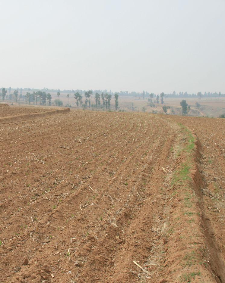
Location: Chao Yang City. Liao Ning Province
Date: Nov 12,2012
Technical knowledge required for field staff / advisors: moderate (Field staff/agricultural advisor should have intermediate know-how level, because land user should be instructed by them)
Technical knowledge required for land users: low (The knowledge level of lander user is not required to be high, who just need(s) to follow the instructions from field staff/agricultural advisor)
Main technical functions: control of dispersed runoff: retain / trap, control of dispersed runoff: impede / retard, reduction of slope length, improvement of water quality, buffering / filtering water, sediment retention / trapping, sediment harvesting
Secondary technical functions: control of concentrated runoff: retain / trap, control of concentrated runoff: impede / retard, improvement of ground cover, improvement of topsoil structure (compaction), increase in organic matter, increase in nutrient availability (supply, recycling,…), increase of infiltration, increase / maintain water stored in soil, water harvesting / increase water supply, water spreading, increase of biomass (quantity), promotion of vegetation species and varieties (quality, eg palatable fodder), spatial arrangement and diversification of land use
Aligned: -contour
Vegetative material: F : fruit trees / shrubs
Number of plants per (ha): 200-600
Vertical interval between rows / strips / blocks (m): 5.644-8.466
Spacing between rows / strips / blocks (m): 40-60
Vertical interval within rows / strips / blocks (m): 0.5
Width within rows / strips / blocks (m): 0.5
Fruit trees / shrubs species: caragana, lespedeza, amorpha, daylily, Melilotus
Slope (which determines the spacing indicated above): 5-8%
Gradient along the rows / strips: 0%
Wall/ barrier
Vertical interval between structures (m): 2.09-5.55
Spacing between structures (m): 40-60
Height of bunds/banks/others (m): 0.3-0.5
Width of bunds/banks/others (m): 0.5-1
Length of bunds/banks/others (m): >100
Construction material (earth): The soil should be free from such sundries as gravels, tree roots and turfs.
Slope (which determines the spacing indicated above): 5-8%
Lateral gradient along the structure: 0%
ຜູ້ຂຽນ:
Zhao Mei, Beijing Normal University, Beijing, China
4.2 ຂໍ້ມູນທົ່ວໄປກ່ຽວກັບການຄິດໄລ່ປັດໃຈຂາເຂົ້າໃນການຜະລິດ ແລະ ມູນຄ່າອື່ນໆ
ສະກຸນເງິນອື່ນໆ / ປະເທດອື່ນໆ (ລະບຸ):
RMB
ຖ້າກ່ຽວຂ້ອງ, ໃຫ້ລະບຸອັດຕາແລກປ່ຽນຈາກ USD ເປັນສະກຸນເງິນທ້ອງຖິ່ນ (ເຊັ່ນ: 1 USD = 79.9 Brazilian Real): 1 USD =:
6.25
ລະບຸ ຄ່າຈ້າງ ຄ່າແຮງງານສະເລ່ຍ ຕໍ່ ວັນ:
9.25
4.3 ການສ້າງຕັ້ງກິດຈະກໍາ
| ກິດຈະກໍາ | Timing (season) | |
|---|---|---|
| 1. | Plant shrubbery | autumn |
| 2. | Layout of contour and the line of SBSWB with the leveling | autumn |
| 3. | Build the ridge | autumn |
4.4 ຕົ້ນທຶນ ແລະ ປັດໄຈຂາເຂົ້າທີ່ຈໍາເປັນໃນຈັດຕັ້ງປະຕິບັດ
| ລະບຸ ປັດໃຈ ນໍາເຂົ້າ ໃນການຜະລີດ | ຫົວໜ່ວຍ | ປະລິມານ | ຕົ້ນທຶນ ຕໍ່ຫົວໜ່ວຍ | ຕົ້ນທຶນທັງໝົດ ຂອງປັດໃຈຂາເຂົ້າ ໃນການຜະລິດ | % ຂອງຕົ້ນທຶນທັງໝົດ ທີ່ຜູ້ນໍາໃຊ້ທີ່ດິນ ໃຊ້ຈ່າຍເອງ | |
|---|---|---|---|---|---|---|
| ແຮງງານ | Layout of contour | Person/day | 3.0 | 16.0 | 48.0 | |
| ແຮງງານ | Build ridge | Person/day | 36.0 | 9.6 | 345.6 | |
| ອຸປະກອນ | Machine use | hours/day | 1.0 | 80.0 | 80.0 | |
| ອຸປະກອນ | tools | day | 1.0 | 8.0 | 8.0 | |
| ວັດສະດຸໃນການປູກ | Seedling Plant shrubbery | ha | 600.0 | 0.016 | 9.6 | |
| ຕົ້ນທຶນທັງໝົດ ໃນການຈັດຕັ້ງປະຕິບັດ ເຕັກໂນໂລຢີ | 491.2 | |||||
| ຄ່າໃຊ້ຈ່າຍທັງໝົດ ສຳລັບການສ້າງຕັ້ງເຕັກໂນໂລຢີ ເປັນສະກຸນເງີນໂດລາ | 78.59 | |||||
ຄວາມຄິດເຫັນ:
Duration of establishment phase: 1 month(s)
4.5 ບໍາລຸງຮັກສາ / ແຜນຈັດຕັ້ງປະຕິບັດ ກິດຈະກໍາ
| ກິດຈະກໍາ | ໄລຍະເວລາ / ຄວາມຖີ່ | |
|---|---|---|
| 1. | The farmers will actively protect the Bund in their land. Don't need money. | autumn |
| 2. | The farmers will actively protect the Bund in their land. Don't need money. | autumn |
4.6 ຄ່າໃຊ້ຈ່າຍ ແລະ ປັດໄຈນໍາເຂົ້າທີ່ຈໍາເປັນສໍາລັບການບໍາລຸງຮັກສາກິດຈະກໍາ / ແຜນປະຕິບັດ (ຕໍ່ປີ)
ຄວາມຄິດເຫັນ:
Machinery/ tools: Spade, Spade
3 people are required to layout contour, daily labor cost for per person is 100 Yuan, so the total labor cost is 300Yuan ($48), tools fee is 50Yuan ($8).
One tractor can built 2.6 ha of ridges per day at a cost of 500 Yuan ($80). The ridges constructed should be artificially tamped, 120 people are needed to tamp the ridges in an area of 2.6ha, about 46 people for each hectare. As the daily labor cost for per person is 60 Yuan, the total expense on each hectare is 2760 Yuan($441.6), and the labor intensity is intermediate.
If shrubs are planted on the ridges, 400 shrubs are required for each 1 hectare management area. In addition, as the price of caragana microphylla in 2012 is 0.1 Yuan per one, the total cost of the caragana microphyllas per hectare should be 40Yuan($6.4).
Therefore, the total construction cost per hectare is 3650Yuan($584).
4.7 ປັດໄຈ ທີ່ສໍາຄັນ ທີ່ສົ່ງຜົນກະທົບ ຕໍ່ຄ່າໃຊ້ຈ່າຍ
ໃຫ້ອະທິບາຍ ປັດໃຈ ທີ່ສົ່ງຜົນກະທົບ ຕໍ່ຕົ້ນທຶນ ໃນການຈັດຕັ້ງປະຕິບັດ:
The most determinate fators affecting the cost is labour
5. ສະພາບແວດລ້ອມທໍາມະຊາດ ແລະ ມະນຸດ
5.1 ອາກາດ
ປະລິມານນໍ້າຝົນປະຈໍາປີ
- < 250 ມີລິແມັດ
- 251-500 ມີລິແມັດ
- 501-750 ມີລິແມັດ
- 751-1,000 ມີລິແມັດ
- 1,001-1,500 ມີລິແມັດ
- 1,501-2,000 ມີລິແມັດ
- 2,001-3,000 ມີລິແມັດ
- 3,001-4,000 ມີລິແມັດ
- > 4,000 ມີລິແມັດ
ເຂດສະພາບອາກາດກະສິກໍາ
- ເຄີ່ງຄວາມຊຸ່ມ
- ເຄິ່ງແຫ້ງແລ້ງ
Thermal climate class: temperate
Thermal climate class: boreal
5.2 ພູມິປະເທດ
ຄ່າສະເລ່ຍ ຄວາມຄ້ອຍຊັນ:
- ພື້ນທີ່ຮາບພຽງ (0-2%)
- ອ່ອນ (3-5 %)
- ປານກາງ (6-10 %)
- ມ້ວນ (11-15 %)
- ເນີນ(16-30%)
- ໍຊັນ (31-60%)
- ຊັນຫຼາຍ (>60%)
ຮູບແບບຂອງດິນ:
- ພູພຽງ / ທົ່ງພຽງ
- ສັນພູ
- ເປີ້ນພູ
- ເນີນພູ
- ຕີນພູ
- ຮ່ອມພູ
ເຂດລະດັບສູງ:
- 0-100 ແມັດ a.s.l.
- 101-500 ແມັດ a.s.l.
- 501-1,000 ແມັດ a.s.l.
- 1,001-1,500 ແມັດ a.s.l.
- 1,501-2,000 ແມັດ a.s.l.
- 2,001-2,500 ແມັດ a.s.l.
- 2,501-3,000 ແມັດ a.s.l.
- 3,001-4,000 ແມັດ a.s.l.
- > 4,000 ແມັດ a.s.l.
5.3 ດິນ
ຄວາມເລິກ ຂອງດິນສະເລ່ຍ:
- ຕື້ນຫຼາຍ (0-20 ຊັງຕີແມັດ)
- ຕື້ນ (21-50 ຊຕມ)
- ເລີກປານກາງ (51-80 ຊຕມ)
- ເລິກ (81-120 ຊມ)
- ເລິກຫຼາຍ (> 120 cm)
ເນື້ອດິນ (ໜ້າດິນ):
- ປານກາງ (ດິນໜຽວ, ດິນໂຄນ)
ຊັ້ນອິນຊີວັດຖຸ ເທິງໜ້າດິນ:
- ສູງ (> 3 %)
- ປານກາງ (1-3 %)
ຖ້າເປັນໄປໄດ້ ແມ່ນໃຫ້ຕິດຄັດ ການພັນລະນາດິນ ຫຼື ຂໍ້ມູນສະເພາະຂອງດິນ, ຕົວຢ່າງ, ຄຸນລັກສະນະ ປະເພດຂອງດິນ, ຄ່າຄວາມເປັນກົດ / ເປັນດ່າງຂອງດິນ, ສານອາຫານ, ດິນເຄັມ ແລະ ອື່ນໆ.
Soil fertility: high
Soil drainage / infiltration: good
Soil water storage capacity: low - medium
5.4 ມີນໍ້າ ແລະ ຄຸນນະພາບ
ລະດັບ ນໍ້າໃຕ້ດິນ:
5-50 ແມັດ
ການມີນໍ້າ ເທິງໜ້າດິນ:
ດີ
ຄຸນນະພາບນໍ້າ (ບໍ່ມີການບໍາບັດ):
ນຳໃຊ້ເຂົ້າໃນການຜະລິດກະສິກໍາພຽງຢ່າງດຽງ (ຊົນລະປະທານ)
5.5 ຊີວະນາໆພັນ
ຄວາມຫຼາກຫຼາຍ ທາງສາຍພັນ:
- ປານກາງ
5.6 ຄຸນລັກສະນະ ຂອງຜູ້ນໍາໃຊ້ທີ່ດິນ ທີ່ໄດ້ນໍາໃຊ້ເຕັກໂນໂລຢີ
ລະບົບ ການຕະຫຼາດ ແລະ ຜົນຜະລິດ:
- ປະສົມປົນເປ( ກຸ້ມຕົນເອງ/ເປັນສິນຄ້າ)
ລາຍຮັບ ທີ່ບໍ່ໄດ້ມາຈາກ ການຜະລິດ ກະສິກໍາ:
- > 50 % ຂອງລາຍຮັບທັງໝົດ
ລະດັບຄວາມຮັ່ງມີ:
- ສະເລ່ຍ
- ຮັ່ງມີ
ບຸກຄົນ ຫຼື ກຸ່ມ:
- ກຸ່ມ / ຊຸມຊົນ
ລະດັບ ການຫັນເປັນກົນຈັກ:
- ການໃຊ້ແຮງງານຄົນ
- ເຄື່ອງກົນຈັກ
ເພດ:
- ຜູ້ຍິງ
- ຜູ້ຊາຍ
ໃຫ້ລະບຸ ຄຸນລັກສະນະ ຂອງຜູ້ນໍາໃຊ້ທີ່ດິນ:
Land users applying the Technology are mainly common / average land users
Population density: 50-100 persons/km2
Annual population growth: < 0.5%
5% of the land users are very rich.
45% of the land users are rich.
35% of the land users are average wealthy.
15% of the land users are poor.
5% of the land users are poor.
5.7 ເນື້ອທີ່ສະເລ່ຍຂອງດິນ ທີ່ຜູ້ນຳໃຊ້ທີ່ດິນ ໃຊ້ເຮັດເຕັກໂນໂລຢີ
- <0.5 ເຮັກຕາ
- 0.5-1 ເຮັກຕາ
- 1-2 ເຮັກຕາ
- 2-5 ເຮັກຕາ
- 5-15 ເຮັກຕາ
- 15-50 ເຮັກຕາ
- 50-100 ເຮັກຕາ
- 100-500 ເຮັກຕາ
- 500-1,000 ເຮັກຕາ
- 1,000-10,000 ເຮັກຕາ
- > 10,000 ເຮັກຕາ
ຖືໄດ້ວ່າ ເປັນຂະໜາດນ້ອຍ, ກາງ ຫຼື ໃຫຍ່ (ອີງຕາມເງື່ອນໄຂ ສະພາບຄວາມເປັນຈິງ ຂອງທ້ອງຖີ່ນ)? :
- ຂະໜາດກາງ
5.8 ເຈົ້າຂອງທີ່ດິນ, ສິດໃຊ້ທີ່ດິນ, ແລະ ສິດທິການນໍາໃຊ້ນໍ້າ
ເຈົ້າຂອງດິນ:
- ຊຸມຊົນ / ບ້ານ
ສິດທິ ໃນການນໍາໃຊ້ທີ່ດິນ:
- ບຸກຄົນ
ສິດທິ ໃນການນໍາໃຊ້ນໍ້າ:
- ຊຸມຊົນ (ທີ່ມີການຈັດຕັ້ງ)
5.9 ການເຂົ້າເຖິງການບໍລິການ ແລະ ພື້ນຖານໂຄງລ່າງ
ສຸຂະພາບ:
- ທຸກຍາກ
- ປານກາງ
- ດີ
ການສຶກສາ:
- ທຸກຍາກ
- ປານກາງ
- ດີ
ການຊ່ວຍເຫຼືອ ດ້ານວິຊາການ:
- ທຸກຍາກ
- ປານກາງ
- ດີ
ການຈ້າງງານ (ຕົວຢ່າງ, ການເຮັດກິດຈະກໍາອື່ນ ທີ່ບໍ່ແມ່ນ ການຜະລິດກະສິກໍາ):
- ທຸກຍາກ
- ປານກາງ
- ດີ
ຕະຫຼາດ:
- ທຸກຍາກ
- ປານກາງ
- ດີ
ພະລັງງານ:
- ທຸກຍາກ
- ປານກາງ
- ດີ
ຖະໜົນຫົນທາງ ແລະ ການຂົນສົ່ງ:
- ທຸກຍາກ
- ປານກາງ
- ດີ
ການດື່ມນໍ້າ ແລະ ສຸຂາພິບານ:
- ທຸກຍາກ
- ປານກາງ
- ດີ
ການບໍລິການ ທາງດ້ານການເງິນ:
- ທຸກຍາກ
- ປານກາງ
- ດີ
6. ຜົນກະທົບ ແລະ ລາຍງານສະຫຼຸບ
6.1 ການສະແດງຜົນກະທົບ ພາຍໃນພື້ນທີ່ ທີ່ໄດ້ຈັດຕັ້ງປະຕິບັດ ເຕັກໂນໂລຢີ
ຜົນກະທົບທາງເສດຖະກິດສັງຄົມ
ການຜະລິດ
ການຜະລິດພືດ
ການຜະລິດອາຫານສັດ
ຄຸນນະພາບຂອງອາຫານສັດ
ຜົນຜະລິດຂອງສັດ
ຜົນຜະລິດໄມ້
ຄວາມໜາແໜ້ນ ຂອງຜົນຜະລິດ
ເນື້ອທີ່ການຜະລິດ
ການຈັດການຄຸ້ມຄອງທີ່ດິນ
ການຜະລິດພະລັງງານ
ມີນໍ້າ ແລະ ຄຸນນະພາບ
ມີນໍ້າດື່ມ
ມີນໍ້າ ໃຫ້ສັດລ້ຽງ
ຄຸນນະພາບ ຂອງນໍ້າ ສໍາລັບລ້ຽງສັດ
ມີນໍ້າຊົນລະປະທານ
ຄຸນນະພາບ ຂອງນໍ້າຊົນລະປະທານ
ຄວາມຕ້ອງການ ນໍ້າຊົນລະປະທານ
ລາຍໄດ້ ແລະ ຄ່າໃຊ້ຈ່າຍ
ຄ່າໃຊ້ຈ່າຍ ປັດໄຈນໍາເຂົ້າ ໃນການຜະລິດກະສິກໍາ
ລາຍຮັບ ຈາກການຜະລີດ
ຄວາມຫຼາກຫຼາຍ ຂອງແຫຼ່ງລາຍຮັບ
ຄວາມແຕກຕ່າງ ທາງດ້ານເສດຖະກິດ
ມີວຽກໜັກ
ຜົນກະທົບດ້ານວັດທະນາທໍາສັງຄົມ
ກາລະໂອກາດ ທາງດ້ານວັດທະນະທໍາ
ໂອກາດ ໃນການພັກຜ່ອນຢ່ອນໃຈ
ສະຖາບັນ ການຈັດຕັ້ງຊຸມຊົນ
ສະຖາບັນແຫ່ງຊາດ
ການຫຼຸດຜ່ອນ ຂໍ້ຂັດແຍ່ງ
Livelihoods and human well-being
ຜົນກະທົບຕໍ່ລະບົບນິເວດ
ວົງຈອນນໍ້າ / ນໍ້າ
ປະລິມານນໍ້າ
ຄຸນນະພາບນໍ້າ
ການຂຸດຄົ້ນ / ການເກັບກັກນໍ້າ
ການໄຫຼ ຂອງນໍ້າໜ້າດິນ
ການລະບາຍນໍ້າ
ຊັ້ນນໍ້າໄຕ້ດິນ / ນໍ້າ
ການລະເຫີຍອາຍ
ດິນ
ຄວາມຊຸ່ມຂອງດິນ
ການປົກຄຸມຂອງດິນ
ການສູນເສຍດິນ
ດິນເປັນຜົງ / ການຈັບໂຕຂອງດິນ ທີ່ມີຂະໜາດນ້ອຍຫຼາຍ ທີ່ມີການຈັບໂຕກັນເປັນກ້ອນ
ການອັດແໜ້ນຂອງດິນ
ວົງຈອນ ຂອງສານອາຫານໃນດິນ
ດິນເຄັມ
ອິນຊີວັດຖຸໃນດິນ / ຢູ່ລຸ່ມຊັ້ນດິນ C
ຊີວະນານາພັນ: ສັດ, ພືດ
ມວນຊີວະພາບ / ຢູ່ເທິງຊັ້ນດິນ C
ຄວາມຫຼາກຫຼາຍຂອງພືດ
ຄວາມຫຼາກຫຼາຍຂອງສັດ
ຊະນິດທີ່ເປັນປະໂຫຍດ
ການຫຼຸດຜ່ອນ ຄວາມສ່ຽງ ຈາກໄພພິບັດ ແລະ ອາກາດປ່ຽນແປງ
ການລະເຫີຍອາຍກາກບອນ ແລະ ອາຍຜິດເຮືອນແກ້ວ
ຄວາມຮູນແຮງ ຂອງລົມ
6.2 ຜົນກະທົບທາງອ້ອມ ຈາກການນໍາໃຊ້ເຕັກໂນໂລຢີ
ສາມາດເຂົ້າເຖິງແຫຼ່ງນໍ້າ
ການໄຫຼຂອງນໍ້າໃນລະດູແລ້ງ
ນໍ້າຖ້ວມຢູ່ເຂດລຸ່ມນໍ້າ
ການທັບຖົມ ຂອງດິນຕະກອນ ຢູ່ເຂດລຸ່ມນໍ້າ
ມົນລະພິດ ທາງນໍ້າ / ນໍ້າໄຕ້ດິນ
ການປ້ອງກັນ / ຄວາມອາດສາມາດ ການກັ່ນຕອງ
ລົມ ທີ່ພັດເອົາຕະກອນ
ພື້ນທີ່ທໍາການຜະລິດ ຂອງເພື່ອນບ້ານທີ່ຢູ່ໃກ້ຄຽງ ໄດ້ຮັບຜົນກະທົບ
ຄວາມເສຍຫາຍ ກ່ຽວກັບພື້ນຖານໂຄງລ່າງ ສາທາລະນະ / ເອກກະຊົນ
6.3 ການປ້ອງກັນ ແລະ ຄວາມບອບບາງ ຂອງເຕັກໂນໂລຢິ ໃນການປ່ຽນແປງສະພາບດິນຟ້າອາກາດ ແລະ ກ່ຽວຂ້ອງກັບອາກາດທີ່ມີການປ່ຽນແປງທີ່ຮຸນແຮງ / ໄພພິບັດທາງທໍາມະຊາດ (ຮັບຮູ້ໄດ້ໂດຍຜູ້ນໍາໃຊ້ທີ່ດິນ)
ການປ່ຽນແປງດິນຟ້າອາກາດ ເທື່ອລະກ້າວ
ການປ່ຽນແປງດິນຟ້າອາກາດ ເທື່ອລະກ້າວ
| ລະດູການ | ເພີ່ມຂື້ນ ຫຼື ຫຼຸດລົງ | ການນໍາໃຊ້ ເຕັກໂນໂລຢີ ສາມາດ ຮັບມື ໄດ້ຄືແນວໃດ? | |
|---|---|---|---|
| ອຸນຫະພູມປະຈໍາປີ | ເພີ່ມຂື້ນ | ດີ |
ອາກາດ ທີ່ກ່ຽວພັນກັບຄວາມຮຸນແຮງ (ໄພພິບັດທາງທໍາມະຊາດ)
ໄພພິບັດທາງອຸຕຸນິຍົມ
| ການນໍາໃຊ້ ເຕັກໂນໂລຢີ ສາມາດ ຮັບມື ໄດ້ຄືແນວໃດ? | |
|---|---|
| ພະຍຸຝົນ | ດີ |
| ພາຍຸລົມທ້ອງຖິ່ນ | ດີ |
ໄພພິບັດທາງພູມອາກາດ
| ການນໍາໃຊ້ ເຕັກໂນໂລຢີ ສາມາດ ຮັບມື ໄດ້ຄືແນວໃດ? | |
|---|---|
| ແຫ້ງແລ້ງ | ດີ |
ໄພພິບັດທາງອຸທົກກະສາກ
| ການນໍາໃຊ້ ເຕັກໂນໂລຢີ ສາມາດ ຮັບມື ໄດ້ຄືແນວໃດ? | |
|---|---|
| ໂດຍທົ່ວໄປ (ແມ່ນໍ້າ) ນໍ້າຖ້ວມ | ດີ |
ຜົນສະທ້ອນສະພາບອາກາດອື່ນໆທີ່ກ່ຽວຂ້ອງ
ຜົນສະທ້ອນສະພາບອາກາດອື່ນໆທີ່ກ່ຽວຂ້ອງ
| ການນໍາໃຊ້ ເຕັກໂນໂລຢີ ສາມາດ ຮັບມື ໄດ້ຄືແນວໃດ? | |
|---|---|
| ໄລຍະເວລາການຂະຫຍາຍຕົວຫຼຸດລົງ | ດີ |
6.4 ການວິເຄາະຕົ້ນທຶນ ແລະ ຜົນປະໂຫຍດ
ຈະເຮັດປະໂຫຍດເພື່ອປຽບທຽບກັບຄ່າໃຊ້ຈ່າຍກັບສິ່ງກໍ່ສ້າງ (ຈາກທັດສະນະຂອງຜູ້ນຳໃຊ້ທີ່ດິນ) ໄດ້ແນວໃດ?
ຜົນຕອບແທນ ໃນໄລຍະສັ້ນ:
ຜົນກະທົບທາງລົບເລັກນ້ອຍ
ຜົນຕອບແທນ ໃນໄລຍະຍາວ:
ຜົນກະທົບທາງບວກ
ຈະໄດ້ຮັບຜົນປະໂຫຍດເມື່ອປຽບທຽບກັບ / ຄ່າໃຊ້ຈ່າຍໃນການບຳລຸງຮັກສາທີເ່ກີດຂື້ນອິກ (ຈາກທັດສະນະຄະຕິຂອງຜູ້ນຳໃຊ້ທີ່ດິນ) ໄດ້ແນວໃດ?
ຜົນຕອບແທນ ໃນໄລຍະສັ້ນ:
ປານກາງ
ຜົນຕອບແທນ ໃນໄລຍະຍາວ:
ຜົນກະທົບທາງບວກຫຼາຍ
ຄວາມຄິດເຫັນ:
Although Certain quantity of land will be occupied and grain output will be affected in SBSWS during the early period of a construction, in the long run, SBSWS can prevent the loss of the most fertile surface soil, in addition, with the ever increased quantity of the sediment intercepted by SBSWS and as the heights of the vegetational belts increase year by year, the slope croplands will become bench terraces, and the grain output will be increased.
6.5 ການປັບຕົວຮັບເອົາເຕັກໂນໂລຢີ
ຖ້າຫາກວ່າມີ, ປະລິມານ (ຈໍານວນຂອງຄົວເຮືອນ / ເນື້ອທີ່ການຄຸ້ມຄອງ):
NA
ຄວາມຄິດເຫັນ:
80% of land user families have adopted the Technology with external material support
Comments on acceptance with external material support: Large-area popularization of SBSWB has been achieved in the locality.
20% of land user families have adopted the Technology without any external material support
Comments on spontaneous adoption: The implementation of this measure was accomplished under the encouragement and support of the government. There are relatively few peasant households who initially take this measure. The main reason for the peasant reluctance to adopt this measure is that the ridges will occupy land and reduce arable area. They are unconscious of and do not care about soil loss, and unable to realize in the long run the harm brought about by soil loss.
There is a little trend towards spontaneous adoption of the Technology
Comments on adoption trend: The trend depands on government support
6.7 ຈຸດແຂງ / ຂໍ້ດີ / ໂອກາດ ໃນການນໍາໃຊ້ ເຕັກໂນໂລຢີ
| ຈຸດແຂງ / ຂໍ້ດີ / ໂອກາດໃນການນໍາໃຊ້ທີ່ດິນ |
|---|
|
Convenient for construction How can they be sustained / enhanced? Popularization carried on |
| ຈຸດແຂງ / ຈຸດດີ / ໂອກາດ ຈາກທັດສະນະຂອງຜູ້ປ້ອນຂໍ້ມູນ ຫຼື ບຸກຄົນສຳຄັນ |
|---|
|
Gradual formation of the slope-type terraces, which can be developed into bench terraces many years later How can they be sustained / enhanced? Increase of ridge height year by year |
|
Intercepting the sediments carried by runoffs, preventing water and soil loss of the arable lands on the gentle slopes How can they be sustained / enhanced? In combination with other water and soil conservation measures during operation, such as no-tillage and drainage ditches; |
|
increase of infiltration How can they be sustained / enhanced? Chopping down branches at regular intervals to guarantee that the plants on the ridges will not enter into rivary with the crops over water and sunlight; |
6.8 ຈຸດອ່ອນ / ຂໍ້ເສຍ / ຄວາມສ່ຽງ ໃນການນໍາໃຊ້ ເຕັກໂນໂລຢີ ແລະ ວິທີການແກ້ໄຂບັນຫາ
| ຈຸດອ່ອນ / ຂໍ້ເສຍ / ຄວາມສ່ຽງໃນມຸມມອງຂອງຜູ້ນໍາໃຊ້ທີ່ດິນ | ມີວິທີການແກ້ໄຂຄືແນວໃດ? |
|---|---|
| The ridges occupy land and reduce arable area | government support |
| ຈຸດອ່ອນ/ຂໍ້ບົກຜ່ອງ/ຄວາມສ່ຽງ ຈາກທັດສະນະຂອງຜູ້ປ້ອນຂໍ້ມູນ ຫຼື ບຸກຄົນສຳຄັນ | ມີວິທີການແກ້ໄຂຄືແນວໃດ? |
|---|---|
| Reduction of arable lands brings about low enthusiasm of the peasants | Conflict between the arable lands and the immediate interests of the peasants. Popularization of water and soil preservation knowledge should be strangthened to make the presants realize that although the immediate interests will be hurt, the long-term interests will increase. |
7. ເອກະສານອ້າງອີງ ແລະ ການເຊື່ອມຕໍ່
7.1 ວິທີການ / ແຫຼ່ງຂໍ້ມູນ
7.2 ເອກກະສານອ້າງອີງທີ່ເປັນບົດລາຍງານ
ຫົວຂໍ້, ຜູ້ຂຽນ, ປີ, ISBN:
Title:Techniques standard for comprehensive control of soil erosion in the black soil region Author:Shen bo; Meng lingqinYears:2009
ມີຢູ່ໃສ?ມູນຄ່າເທົ່າໃດ?
internal materials
ຂໍ້ມູນການເຊື່ອມຕໍ່ ແລະ ເນື້ອໃນ
ຂະຫຍາຍທັງໝົດ ຍຸບທັງໝົດການເຊື່ອມຕໍ່
ບໍ່ມີຂໍ້ມູນການເຊື່ອມຕໍ່
ເນື້ອໃນ
ບໍ່ມີເນື້ອໃນ