Vegetated graded soil bund [ອີທິໂອເປຍ]
- ການສ້າງ:
- ປັບປູງ:
- ຜູ້ສັງລວມຂໍ້ມູນ: Gizaw Desta Gessesse
- ບັນນາທິການ: –
- ຜູ້ທົບທວນຄືນ: Deborah Niggli, Alexandra Gavilano
Yeafer Erken (Amharic)
technologies_1601 - ອີທິໂອເປຍ
ເບິ່ງພາກສ່ວນ
ຂະຫຍາຍທັງໝົດ ຍຸບທັງໝົດ1. ຂໍ້ມູນທົ່ວໄປ
1.2 ຂໍ້ມູນ ການຕິດຕໍ່ພົວພັນ ຂອງບຸກຄົນທີ່ສໍາຄັນ ແລະ ສະຖາບັນ ທີ່ມີສ່ວນຮ່ວມ ໃນການປະເມີນເອກກະສານ ເຕັກໂນໂລຢີ
ຊື່ໂຄງການ ທີ່ອໍານວຍຄວາມສະດວກ ໃນການສ້າງເອກກະສານ/ປະເມີນ ເຕັກໂນໂລຢີ (ຖ້າກ່ຽວຂ້ອງ)
Water and Land Resource Centre Project (WLRC)1.3 ເງື່ອນໄຂ ກ່ຽວກັບ ການນໍາໃຊ້ຂໍ້ມູນເອກະສານ ທີ່ສ້າງຂື້ນ ໂດຍຜ່ານ ອົງການພາບລວມຂອງໂລກ ທາງດ້ານແນວທາງ ແລະ ເຕັກໂນໂລຢີ ຂອງການອານຸລັກ ທໍາມະຊາດ (WOCAT)
ຜູ້ປ້ອນຂໍ້ມູນ ແລະ ບຸກຄົນສຳຄັນ ທີ່ໃຫ້ຂໍ້ມູນ (ຫຼາຍ) ຍິນຍອມ ຕາມເງື່ອນໄຂ ໃນການນຳໃຊ້ຂໍ້ມູນ ເພື່ອສ້າງເປັນເອກກະສານຂອງ WOCAT:
ແມ່ນ
1.4 ແຈ້ງການວ່າ ດ້ວຍຄວາມຍືນຍົງຂອງ ເຕັກໂນໂລຢີ
ການນໍາໃຊ້ ເຕັກໂນໂລຢີ ດັ່ງກ່າວໄດ້ອະທິບາຍ ເຖິງບັນຫາ ກ່ຽວກັບ ການເຊື່ອມໂຊມຂອງດິນບໍ? ຖ້າບໍ່ດັ່ງນັ້ນ ມັນບໍ່ສາມາດ ຢັ້ງຢືນໄດ້ວ່າ ເປັນເຕັກໂນໂລຊີ ໃນການຄຸ້ມຄອງ ທີ່ດິນແບບຍືນຍົງ? :
ບໍ່ແມ່ນ
1.5 ແບບສອບຖາມທີ່ອ້າງອີງເຖີງແນວທາງ ການຄຸ້ມຄອງທີ່ດິນແບບຍືນຍົງ (ໄດ້ເຮັດເປັນເອກະສານທີ່ໃຊ້ WOCAT)
Community Organizations and Mobilization for Soil and Water … [ອີທິໂອເປຍ]
Community mobilization for soil and water conservation work in a watershed planning unit is an approach for collective action by organizing all active labor forces living in the kebele/peasant association into development group of 20-30 members and further divide into 1:5 work force to implement construction of soil and water …
- ຜູ້ສັງລວມຂໍ້ມູນ: Gizaw Desta Gessesse
'Cut and Carry' Grazing system or 'Zero Grazing' … [ອີທິໂອເປຍ]
Cut and carry grazing system (alternatively called zero grazing) is an approach where the community is consulted to identify and agree on areas to be closed and protected from free grazing; establish user groups are established to share the fodder biomass harvested from communal closed areas equitably; they utilize tree/shrub …
- ຜູ້ສັງລວມຂໍ້ມູນ: Gizaw Desta Gessesse
2. ການອະທິບາຍ ເຕັກໂນໂລຢີ ຂອງການຄຸ້ມຄອງ ທີ່ດິນແບບຍືນຍົງ
2.1 ຄໍາອະທິບາຍສັ້ນຂອງ ເຕັກໂນໂລຢີ
ການກຳໜົດຄວາມໝາຍ ຂອງເຕັກໂນໂລຢີ:
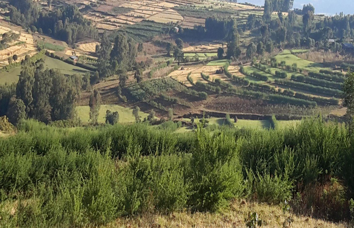
Vegetated graded soil bund is a soil conservation practice meant for cultivated lands and constructed by excavating graded channel on upper side and develop embankment on lower side which is planted with grass or shrub species in order to control soil erosion and drain excess runoff implemented through community mobilization.
2.2 ການອະທິບາຍ ລາຍລະອຽດ ຂອງເຕັກໂນໂລຢີ
ການພັນລະນາ:
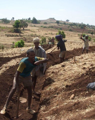
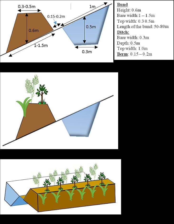
Vegetated graded soil bund is a practice or soil conservation technology for cultivated lands and constructed by excavating graded channel and form embankment. It is practiced in areas where there is excess runoff to be disposed and where there is no stones available for construction. The design specifications (ditch gradient, width and height) and layout (spacing/vertical interval) vary on the amount of excess runoff and slope of the land. Soil bund construction begins from top of the catchment. Cut off drains are constructed on top of the catchment and where needed to drain excess runoff to well stabilized natural or man-made waterways. this helps to reduce runoff impact on gullies. The bund ditch/channel should be sufficient enough to drain excess runoff safely without causing channel erosion and creating downstream damages. At same time the embankment should be stable to withstand overflows and damage due to free grazing. One technique to stabilize bunds is to plant the embankment with grass and shrub species of multiple economic value in order to compensate production area lost by bund construction. Often, the species are preferably used for livestock feed. Thus, free grazing has to be controlled. To protect damage of channels and embankments by extreme runoff and floods, frequent supervision and maintenance is required.
The purposes are:
1) Reduce nutrient loss and soil erosion by shortening the slope length,
2) Safely drain excess runoff from upstream of gully into protected waterways,
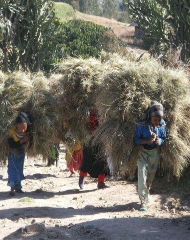
4) Produce biomass of fodder and cash values.
Vegetated graded bunds are established by doing surveying using hand level to determine the layout of the technology along the slope. During the surveying, the position of bunds (spacing) and cutoff drains and connection to waterways are determined. Bunds are laid following 0.05% gradient and up to 80 m maximum length. The specifications of the structure are: height of bund is a minimum of 60 cm after compaction; depending on the soil, base width range between 1.0 and 1.5m; top width is between 30 and 50 cm. The construction is made across different parcels owned by different land users. If there is no natural waterways and where it is appropriate, paved waterways are constructed at every 80 m or less bund length to dispose drainage water. At the beginning of the rainy season, the embankments are covered with grass and/or shrubs either by direct sowing of seeds or planting the seedlings raised in the nurseries. Monitoring of damages due to flooding and animals, maintenance of the structure as well as replanting of dead seedlings on bunds is required to sustain the soil conservation technology.
The technology is appropriately applied in high rainfall and sub-humid areas of the sub-tropics, particularly where the soil is moderately deep and poorly drained. It is constructed on cultivated lands having slopes in the range of 3-15%. The practice can be constructed by land users. It also requires collective decision and actions to drain excess runoff through waterways. The living condition depends on subsistence crop-livestock mixed farming. On average households have 5-6 family size. Crop production is meant for home consumption with small surplus for local market. The services related to water supply, energy supply, and infrastructure are low. Besides it is an asset, animals often used to cope shocks during drought periods.
2.3 ຮູບພາບຂອງເຕັກໂນໂລຢີ
ສື່ຮູບພາບ
2.5 ປະເທດ / ເຂດ / ສະຖານທີ່ບ່ອນທີ່ ເຕັກໂນໂລຢີ ໄດ້ຮັບການນໍາໃຊ້ ແລະ ທີ່ຖືກປົກຄຸມດ້ວຍການປະເມີນຜົນ
ປະເທດ:
ອີທິໂອເປຍ
ພາກພື້ນ / ລັດ / ແຂວງ:
Amhara National Regional State (ANRS)
ຂໍ້ມູນເພີ່ມເຕີມຂອງສະຖານທີ່:
Mecha, Bahirdar Zuria and Yilmana Densa
ຄວາມຄິດເຫັນ:
Total area covered by the SLM Technology is 20 km2.
The technology is applied on specific conditions within the watersheds or area of adoption
2.6 ວັນທີໃນການຈັດຕັ້ງປະຕິບັດ
ຖ້າຫາກວ່າ ບໍ່ຮູ້ຈັກ ປີທີ່ຊັດເຈນ ແມ່ນໃຫ້ປະມານ ວັນທີເອົາ:
- ຕໍ່າກວ່າ 10 ປີ ຜ່ານມາ (ມາເຖິງປະຈຸບັນ)
2.7 ການນໍາສະເໜີ ເຕັກໂນໂລຢີ
ໃຫ້ລະບຸ ເຕັກໂນໂລຢີ ໄດ້ຖືກຈັດຕັ້ງປະຕິບັດຄືແນວໃດ?
- ໂດຍຜ່ານໂຄງການ / ການຊ່ວຍເຫຼືອຈາກພາຍນອກ
ຄວາມຄິດເຫັນ (ປະເພດ ໂຄງການ ແລະ ອື່ນໆ):
The soil bunds are introduced before 30-40 years, however the integration of structural and combination of vegetative measures are applied in three years period in the WLRC learning watersheds.
3. ການໃຈ້ແຍກ ເຕັກໂນໂລຢີ ໃນການຄຸ້ມຄອງ ດິນແບບຍືນຍົງ
3.1 ຈຸດປະສົງຫຼັກ (ຫຼາຍ) ຂອງເຕັກໂນໂລຢີ
- ຫຼຸດຜ່ອນ, ປ້ອງກັນ, ຟື້ນຟູ ການເຊື່ອມໂຊມຂອງດິນ
3.2 ປະເພດການນໍາໃຊ້ທີ່ດິນ ໃນປະຈຸບັນ() ທີ່ເຕັກໂນໂລຢີ ໄດ້ຖືກນໍາໃຊ້

ດິນທີ່ປູກພືດ
- ການປູກພືດປະຈໍາປີ
- ພືດຢືນຕົ້ນ (ບໍ່ແມ່ນໄມ້)
- ເປັນໄມ້ຢືນຕົ້ນ ແລະ ໄມ້ພຸ່ມ ຈາກການປູກພືດ
- Rhamnus, Napier grass
- Cordia Africana, Polycantha, Sesbania Susban, Pigeon pea, Treelucer
ຈໍານວນ ລະດູການ ປູກໃນປີໜຶ່ງ:
- 1
ລະບຸ ຊະນິດ:
Longest growing period in days: 210, Longest growing period from month to month: June-December; Second longest growing period in days: 180, Second longest growing period from month to month: June-November

ທົ່ງຫຍ້າລ້ຽງສັດ
- free grazing
ຄວາມຄິດເຫັນ:
Major land use problems (compiler’s opinion): Land degradation due to sheet erosion, rills and gullies, soil nutrient depletion, overgrazing, shortage of fuel wood, excessive removal of crop residuals, loss of vegetation and deforestation
Major land use problems (land users’ perception): Soil erosion, soil nutrient depletion, shortage of pasture
3.4 ການສະໜອງນ້ຳ
ການສະໜອງນໍ້າ ໃນພື້ນທີ່ ທີ່ໄດ້ນໍາໃຊ້ ເຕັກໂນໂລຢີ:
- ນໍາໃຊ້ ນໍ້າຊົນລະປະທານ ພຽງຢ່າງດຽວ
3.5 ການນໍາໃຊ້ເຕັກໂນໂລຢີ ທີ່ຢູ່ໃນກຸ່ມການຄຸ້ມຄອງ ທີ່ດິນແບບຍືນຍົງ
- ມາດຕະການ ຕັດຂວາງ ກັບຄວາມຄ້ອຍຊັນ
3.6 ມາດຕະການ ການຄຸ້ມຄອງ ທີ່ດິນແບບຍືນຍົງ ປະກອບດ້ວຍ ເຕັກໂນໂລຢີ

ມາດຕະການ ທາງດ້ານພືດພັນ
- V1: ເປັນໄມ້ຢືນຕົ້ນ ແລະ ການປົກຫຸ້ມຂອງໄມ້ພຸ່ມ
- V2: ຫຍ້າ ແລະ ພືດສະໝູນໄພທີ່ເປັນໄມ້ຢືນຕົ້ນ

ມາດຕະການໂຄງສ້າງ
- S2: ຄັນຄຸ, ແຄມຕາຝັ່ງ
- S3: ຮ່ອງ, ຄອງນໍ້າ, ທາງໄຫຼນໍ້າ
ຄວາມຄິດເຫັນ:
Type of vegetative measures: aligned: -graded strips
3.7 ປະເພດດິນເຊື່ອມໂຊມ ຫຼັກທີ່ໄດ້ນໍາໃຊ້ ເຕັກໂນໂລຢີ

ດິນເຊາະເຈື່ອນ ໂດຍນໍ້າ
- Wt: ການສູນເສຍຊັ້ນໜ້າດິນ / ການເຊາະເຈື່ອນຜິວໜ້າດິນ
- Wo: ຜົນກະທົບ ຂອງການເຊື່ອມໂຊມ ຕໍ່ພື້ນທີ່ພາຍນອກ

ການເຊື່ອມໂຊມ ຂອງນໍ້າ
- Hs: ການປ່ຽນແປງ ປະລິມານ ນໍ້າໜ້າດິນ
ຄວາມຄິດເຫັນ:
Main causes of degradation: soil management (High tillage frequency on annual basis and steep slope cultivation), crop management (annual, perennial, tree/shrub) (The cropping system is cereal based that induce erosion), overgrazing (Livestock graze on crop residues after harvesting of crops), Heavy / extreme rainfall (intensity/amounts) (Extreme rainfall cause for high erosion), other natural causes (avalanches, volcanic eruptions, mud flows, highly susceptible natural resources, extreme topography, etc.) specify (Steep slopes or rugged topography), population pressure (Result in expansion of crop lands to steeper slopes)
Secondary causes of degradation: deforestation / removal of natural vegetation (incl. forest fires) (Deforestation of scattered trees in the farm and forests upstream of crop lands), land tenure (Insecure tenure play role not to invest on long term), poverty / wealth (Poor can not afford to invest on soil conservation on his parcel), education, access to knowledge and support services, governance / institutional
3.8 ການປ້ອງກັນ, ການຫຼຸດຜ່ອນ, ຫຼືການຟື້ນຟູຂອງການເຊື່ອມໂຊມຂອງດິນ
ໃຫ້ລະບຸ ເປົ້າໝາຍ ເຕັກໂນໂລຢີ ທີ່ພົວພັນ ກັບຄວາມເຊື່ອມໂຊມຂອງດິນ:
- ຫຼຸດຜ່ອນການເຊື່ອມໂຊມຂອງດິນ
4. ຂໍ້ກໍາໜົດ, ກິດຈະກໍາການປະຕິບັດ, ວັດຖຸດິບ, ແລະຄ່າໃຊ້ຈ່າຍ
4.1 ເຕັກນິກ ໃນການແຕ້ມແຜນວາດ ເຕັກໂນໂລຢີ
ຄຸນລັກສະນະ ຂອງເຕັກນິກ (ທີ່ກ່ຽວຂ້ອງ ກັບການແຕ້ມແຜນວາດ ທາງດ້ານເຕັກນີກ):
Vegetated graded soil bund showing the excavated ditch or channel and the embankment planted with grass and shrubs
Location: Amhara Region. Mecha, Yilmana Densa, Bahir Dar Zuria and Dessie Z
Technical knowledge required for field staff / advisors: high (Layout and design specification of soil bunds and cutoff drains vary on soil types, slopes, and rainfall conditions. Experts thus should acquire knowledge on specific hydrologic conditions)
Technical knowledge required for land users: moderate (Land users need skill to layout and construct bunds, monitor structures before the occurrence of excessive damage, and do regular maintenance)
Main technical functions: control of dispersed runoff: impede / retard, reduction of slope length, sediment retention / trapping, sediment harvesting, increase of biomass (quantity)
Secondary technical functions: control of dispersed runoff: retain / trap, reduction of slope angle, increase / maintain water stored in soil, increase of groundwater level / recharge of groundwater
Aligned: -graded strips
Vegetative material: T : trees / shrubs, C : perennial crops, G : grass
Number of plants per (ha): T=5333, C=160, G=1600
Vertical interval between rows / strips / blocks (m): 1-1.5
Spacing between rows / strips / blocks (m): 10-20
Vertical interval within rows / strips / blocks (m): T=0.3, C=5, G=0.5
Width within rows / strips / blocks (m): 0.3
Trees/ shrubs species: Cordia Africana, Polycantha, Sesbania Susban, Pigeon pea, Treelucer
Perennial crops species: Rhamnus
Grass species: Napier grass
Slope (which determines the spacing indicated above): 3-15%
Gradient along the rows / strips: 0.05%
Diversion ditch/ drainage
Depth of ditches/pits/dams (m): 0.3-0.7
Width of ditches/pits/dams (m): 1.2-2.8
Length of ditches/pits/dams (m): 100-250
Waterway
Depth of ditches/pits/dams (m): 0.3
Width of ditches/pits/dams (m): 1.5-2.0
Bund/ bank: graded
Vertical interval between structures (m): 1-1.5
Spacing between structures (m): 10-20
Depth of ditches/pits/dams (m): 0.5
Width of ditches/pits/dams (m): 0.3
Height of bunds/banks/others (m): 0.6
Width of bunds/banks/others (m): 1-1.5
Length of bunds/banks/others (m): 50-80
Construction material (earth): in-situ excavated soil
Slope (which determines the spacing indicated above): 3-15%
Lateral gradient along the structure: 0.05%
Vegetation is used for stabilisation of structures.
ຜູ້ຂຽນ:
Bekure Melesse, WLRC, P.O.Box 8707, Addis Ababa, Ethiopia
4.2 ຂໍ້ມູນທົ່ວໄປກ່ຽວກັບການຄິດໄລ່ປັດໃຈຂາເຂົ້າໃນການຜະລິດ ແລະ ມູນຄ່າອື່ນໆ
ສະກຸນເງິນອື່ນໆ / ປະເທດອື່ນໆ (ລະບຸ):
ETH BIRR
ຖ້າກ່ຽວຂ້ອງ, ໃຫ້ລະບຸອັດຕາແລກປ່ຽນຈາກ USD ເປັນສະກຸນເງິນທ້ອງຖິ່ນ (ເຊັ່ນ: 1 USD = 79.9 Brazilian Real): 1 USD =:
20.0
ລະບຸ ຄ່າຈ້າງ ຄ່າແຮງງານສະເລ່ຍ ຕໍ່ ວັນ:
2.50
4.3 ການສ້າງຕັ້ງກິດຈະກໍາ
| ກິດຈະກໍາ | Timing (season) | |
|---|---|---|
| 1. | Preparing planting materials | January-May |
| 2. | Preparation of planting materials | January-May |
| 3. | Transportation of grass splits/cuttings | Start of rainy season/July |
| 4. | Transporting tree seedlings | Start of rain season/July |
| 5. | Planting grass splits/cuttings | Start of rainy season/July |
| 6. | Sowing seeds on bunds | Start of rainy season/July |
| 7. | Planting tree seedlings on bunds | Starting of rainy season/July |
| 8. | Surveying (layout of structures) | After crop harvest and before first tillage operation |
| 9. | Construction of cutoff drains | January-April |
| 10. | Construction of bunds (ditch and embankment) | January-April |
| 11. | Construction of waterways | January - April |
4.4 ຕົ້ນທຶນ ແລະ ປັດໄຈຂາເຂົ້າທີ່ຈໍາເປັນໃນຈັດຕັ້ງປະຕິບັດ
| ລະບຸ ປັດໃຈ ນໍາເຂົ້າ ໃນການຜະລີດ | ຫົວໜ່ວຍ | ປະລິມານ | ຕົ້ນທຶນ ຕໍ່ຫົວໜ່ວຍ | ຕົ້ນທຶນທັງໝົດ ຂອງປັດໃຈຂາເຂົ້າ ໃນການຜະລິດ | % ຂອງຕົ້ນທຶນທັງໝົດ ທີ່ຜູ້ນໍາໃຊ້ທີ່ດິນ ໃຊ້ຈ່າຍເອງ | |
|---|---|---|---|---|---|---|
| ແຮງງານ | labour | ha | 1.0 | 1107.0 | 1107.0 | 79.0 |
| ອຸປະກອນ | animal traction | ha | 1.0 | 4.0 | 4.0 | 100.0 |
| ອຸປະກອນ | tools | ha | 1.0 | 300.6 | 300.6 | 50.0 |
| ວັດສະດຸໃນການປູກ | seedlings | ha | 1.0 | 32.0 | 32.0 | 100.0 |
| ວັດສະດຸໃນການປູກ | seeds | ha | 1.0 | 9.0 | 9.0 | 100.0 |
| ວັດສະດຸໃນການປູກ | compost manure | ha | 1.0 | 2.0 | 2.0 | 100.0 |
| ວັດສະດຸກໍ່ສ້າງ | stone | ha | 1.0 | 1300.0 | 1300.0 | 100.0 |
| ວັດສະດຸກໍ່ສ້າງ | wood | ha | 1.0 | 110.0 | 110.0 | 100.0 |
| ວັດສະດຸກໍ່ສ້າງ | earth | ha | 1.0 | 25.2 | 25.2 | 100.0 |
| ຕົ້ນທຶນທັງໝົດ ໃນການຈັດຕັ້ງປະຕິບັດ ເຕັກໂນໂລຢີ | 2889.8 | |||||
| ຄ່າໃຊ້ຈ່າຍທັງໝົດ ສຳລັບການສ້າງຕັ້ງເຕັກໂນໂລຢີ ເປັນສະກຸນເງີນໂດລາ | 144.49 | |||||
ຄວາມຄິດເຫັນ:
Duration of establishment phase: 15 month(s)
4.5 ບໍາລຸງຮັກສາ / ແຜນຈັດຕັ້ງປະຕິບັດ ກິດຈະກໍາ
| ກິດຈະກໍາ | ໄລຍະເວລາ / ຄວາມຖີ່ | |
|---|---|---|
| 1. | Preparation of planting materials | January - May |
| 2. | Transportation of seedlings | July |
| 3. | Re-plantation of seedlings and grass splits | July |
| 4. | Maintenance of bunds, cutoff drain and waterways | January-April |
4.6 ຄ່າໃຊ້ຈ່າຍ ແລະ ປັດໄຈນໍາເຂົ້າທີ່ຈໍາເປັນສໍາລັບການບໍາລຸງຮັກສາກິດຈະກໍາ / ແຜນປະຕິບັດ (ຕໍ່ປີ)
| ລະບຸ ປັດໃຈ ນໍາເຂົ້າ ໃນການຜະລີດ | ຫົວໜ່ວຍ | ປະລິມານ | ຕົ້ນທຶນ ຕໍ່ຫົວໜ່ວຍ | ຕົ້ນທຶນທັງໝົດ ຂອງປັດໃຈຂາເຂົ້າ ໃນການຜະລິດ | % ຂອງຕົ້ນທຶນທັງໝົດ ທີ່ຜູ້ນໍາໃຊ້ທີ່ດິນ ໃຊ້ຈ່າຍເອງ | |
|---|---|---|---|---|---|---|
| ແຮງງານ | labour | ha | 1.0 | 279.0 | 279.0 | 100.0 |
| ວັດສະດຸໃນການປູກ | seedlings | ha | 1.0 | 20.0 | 20.0 | 100.0 |
| ຕົ້ນທຶນທັງໝົດ ທີ່ໃຊ້ໃນການບໍາລຸງຮັກສາ ເຕັກໂນໂລຢີ | 299.0 | |||||
| ຄ່າໃຊ້ຈ່າຍທັງໝົດ ສຳລັບການບົວລະບັດຮກສາເຕັກໂນໂລຢີ ເປັນສະກຸນເງີນໂດລາ | 14.95 | |||||
ຄວາມຄິດເຫັນ:
Machinery/ tools: Cart, plastic tubes, spade, pickaxe, hand level, graduated ranging pole, spade, pickaxe, crowbar, hammer
The costs are calculated based on the labour, seedling/seed, grass splits required per hectare
4.7 ປັດໄຈ ທີ່ສໍາຄັນ ທີ່ສົ່ງຜົນກະທົບ ຕໍ່ຄ່າໃຊ້ຈ່າຍ
ໃຫ້ອະທິບາຍ ປັດໃຈ ທີ່ສົ່ງຜົນກະທົບ ຕໍ່ຕົ້ນທຶນ ໃນການຈັດຕັ້ງປະຕິບັດ:
The cost variation in implementing vegetated soil bund is dependent upon availability of stones, workability of the soil, cost of seeds or seedlings for plantation, and distance for transporting seedlings.
5. ສະພາບແວດລ້ອມທໍາມະຊາດ ແລະ ມະນຸດ
5.1 ອາກາດ
ປະລິມານນໍ້າຝົນປະຈໍາປີ
- < 250 ມີລິແມັດ
- 251-500 ມີລິແມັດ
- 501-750 ມີລິແມັດ
- 751-1,000 ມີລິແມັດ
- 1,001-1,500 ມີລິແມັດ
- 1,501-2,000 ມີລິແມັດ
- 2,001-3,000 ມີລິແມັດ
- 3,001-4,000 ມີລິແມັດ
- > 4,000 ມີລິແມັດ
ຂໍ້ມູນສະເພາະ / ຄວາມເຫັນກ່ຽວກັບ ປະລິມານນໍ້າຝົນ:
Monsoon, 5-6 months rain and 6-7 dry months
ເຂດສະພາບອາກາດກະສິກໍາ
- ເຄີ່ງຄວາມຊຸ່ມ
Thermal climate class: subtropics. he lowest temperature is above 5oc but below 18oc etween November to January
5.2 ພູມິປະເທດ
ຄ່າສະເລ່ຍ ຄວາມຄ້ອຍຊັນ:
- ພື້ນທີ່ຮາບພຽງ (0-2%)
- ອ່ອນ (3-5 %)
- ປານກາງ (6-10 %)
- ມ້ວນ (11-15 %)
- ເນີນ(16-30%)
- ໍຊັນ (31-60%)
- ຊັນຫຼາຍ (>60%)
ຮູບແບບຂອງດິນ:
- ພູພຽງ / ທົ່ງພຽງ
- ສັນພູ
- ເປີ້ນພູ
- ເນີນພູ
- ຕີນພູ
- ຮ່ອມພູ
ເຂດລະດັບສູງ:
- 0-100 ແມັດ a.s.l.
- 101-500 ແມັດ a.s.l.
- 501-1,000 ແມັດ a.s.l.
- 1,001-1,500 ແມັດ a.s.l.
- 1,501-2,000 ແມັດ a.s.l.
- 2,001-2,500 ແມັດ a.s.l.
- 2,501-3,000 ແມັດ a.s.l.
- 3,001-4,000 ແມັດ a.s.l.
- > 4,000 ແມັດ a.s.l.
5.3 ດິນ
ຄວາມເລິກ ຂອງດິນສະເລ່ຍ:
- ຕື້ນຫຼາຍ (0-20 ຊັງຕີແມັດ)
- ຕື້ນ (21-50 ຊຕມ)
- ເລີກປານກາງ (51-80 ຊຕມ)
- ເລິກ (81-120 ຊມ)
- ເລິກຫຼາຍ (> 120 cm)
ເນື້ອດິນ (ໜ້າດິນ):
- ປານກາງ (ດິນໜຽວ, ດິນໂຄນ)
- ບາງລະອຽດ / ໜັກ (ໜຽວ)
ຊັ້ນອິນຊີວັດຖຸ ເທິງໜ້າດິນ:
- ປານກາງ (1-3 %)
- ຕໍາ່ (<1 %)
5.4 ມີນໍ້າ ແລະ ຄຸນນະພາບ
ລະດັບ ນໍ້າໃຕ້ດິນ:
5-50 ແມັດ
ການມີນໍ້າ ເທິງໜ້າດິນ:
ປານກາງ
ຄຸນນະພາບນໍ້າ (ບໍ່ມີການບໍາບັດ):
ບໍ່ມີນໍ້າດື່ມ (ຮຽກຮ້ອງໃຫ້ມີການບຳບັດນ້ຳ)
5.5 ຊີວະນາໆພັນ
ຄວາມຫຼາກຫຼາຍ ທາງສາຍພັນ:
- ຕໍ່າ
5.6 ຄຸນລັກສະນະ ຂອງຜູ້ນໍາໃຊ້ທີ່ດິນ ທີ່ໄດ້ນໍາໃຊ້ເຕັກໂນໂລຢີ
ລະບົບ ການຕະຫຼາດ ແລະ ຜົນຜະລິດ:
- ກຸ້ມຕົນເອງ (ພໍພຽງ)
- ປະສົມປົນເປ( ກຸ້ມຕົນເອງ/ເປັນສິນຄ້າ)
ລາຍຮັບ ທີ່ບໍ່ໄດ້ມາຈາກ ການຜະລິດ ກະສິກໍາ:
- ໜ້ອຍກ່ວາ 10 % ຂອງລາຍຮັບທັງໝົດ
ລະດັບຄວາມຮັ່ງມີ:
- ທຸກຍາກ
- ສະເລ່ຍ
ບຸກຄົນ ຫຼື ກຸ່ມ:
- ບຸກຄົນ / ຄົວເຮືອນ
ລະດັບ ການຫັນເປັນກົນຈັກ:
- ການໃຊ້ແຮງງານຄົນ
- ສັດລາກແກ່
ເພດ:
- ຜູ້ຍິງ
- ຜູ້ຊາຍ
ໃຫ້ລະບຸ ຄຸນລັກສະນະ ຂອງຜູ້ນໍາໃຊ້ທີ່ດິນ:
Land users applying the Technology are mainly common / average land users
Difference in the involvement of women and men: Women are involved in the construction of bunds with role of collecting stones, stabilize/compact the embankments and sometimes help men in excavating the earth
Population density: 200-500 persons/km2
Annual population growth: 2% - 3%
80% of the land users are average wealthy.
20% of the land users are poor.
Off-farm income specification: Land users often do not have access to off-farm income unless those who are young and own small size of land go for seasonal labor to towns during the slack period
5.7 ເນື້ອທີ່ສະເລ່ຍຂອງດິນ ທີ່ຜູ້ນຳໃຊ້ທີ່ດິນ ໃຊ້ເຮັດເຕັກໂນໂລຢີ
- <0.5 ເຮັກຕາ
- 0.5-1 ເຮັກຕາ
- 1-2 ເຮັກຕາ
- 2-5 ເຮັກຕາ
- 5-15 ເຮັກຕາ
- 15-50 ເຮັກຕາ
- 50-100 ເຮັກຕາ
- 100-500 ເຮັກຕາ
- 500-1,000 ເຮັກຕາ
- 1,000-10,000 ເຮັກຕາ
- > 10,000 ເຮັກຕາ
ຖືໄດ້ວ່າ ເປັນຂະໜາດນ້ອຍ, ກາງ ຫຼື ໃຫຍ່ (ອີງຕາມເງື່ອນໄຂ ສະພາບຄວາມເປັນຈິງ ຂອງທ້ອງຖີ່ນ)? :
- ຂະໜາດນ້ອຍ
5.8 ເຈົ້າຂອງທີ່ດິນ, ສິດໃຊ້ທີ່ດິນ, ແລະ ສິດທິການນໍາໃຊ້ນໍ້າ
ເຈົ້າຂອງດິນ:
- ລັດ
ສິດທິ ໃນການນໍາໃຊ້ທີ່ດິນ:
- ບຸກຄົນ
ສິດທິ ໃນການນໍາໃຊ້ນໍ້າ:
- ເປີດກວ້າງ (ບໍ່ມີການຈັດຕັ້ງ)
- ຊຸມຊົນ (ທີ່ມີການຈັດຕັ້ງ)
5.9 ການເຂົ້າເຖິງການບໍລິການ ແລະ ພື້ນຖານໂຄງລ່າງ
ສຸຂະພາບ:
- ທຸກຍາກ
- ປານກາງ
- ດີ
ການສຶກສາ:
- ທຸກຍາກ
- ປານກາງ
- ດີ
ການຊ່ວຍເຫຼືອ ດ້ານວິຊາການ:
- ທຸກຍາກ
- ປານກາງ
- ດີ
ການຈ້າງງານ (ຕົວຢ່າງ, ການເຮັດກິດຈະກໍາອື່ນ ທີ່ບໍ່ແມ່ນ ການຜະລິດກະສິກໍາ):
- ທຸກຍາກ
- ປານກາງ
- ດີ
ຕະຫຼາດ:
- ທຸກຍາກ
- ປານກາງ
- ດີ
ພະລັງງານ:
- ທຸກຍາກ
- ປານກາງ
- ດີ
ຖະໜົນຫົນທາງ ແລະ ການຂົນສົ່ງ:
- ທຸກຍາກ
- ປານກາງ
- ດີ
ການດື່ມນໍ້າ ແລະ ສຸຂາພິບານ:
- ທຸກຍາກ
- ປານກາງ
- ດີ
ການບໍລິການ ທາງດ້ານການເງິນ:
- ທຸກຍາກ
- ປານກາງ
- ດີ
6. ຜົນກະທົບ ແລະ ລາຍງານສະຫຼຸບ
6.1 ການສະແດງຜົນກະທົບ ພາຍໃນພື້ນທີ່ ທີ່ໄດ້ຈັດຕັ້ງປະຕິບັດ ເຕັກໂນໂລຢີ
ຜົນກະທົບທາງເສດຖະກິດສັງຄົມ
ການຜະລິດ
ການຜະລິດພືດ
ຄວາມຄິດເຫັນ / ລະບຸແຈ້ງ:
Crop yield increase on sedimentation area of bunds
ການຜະລິດອາຫານສັດ
ຄວາມຄິດເຫັນ / ລະບຸແຈ້ງ:
Introduction of fodder crops on bunds
ຄຸນນະພາບຂອງອາຫານສັດ
ຄວາມຄິດເຫັນ / ລະບຸແຈ້ງ:
Introduction of high value forage crops
ເນື້ອທີ່ການຜະລິດ
ຄວາມຄິດເຫັນ / ລະບຸແຈ້ງ:
The area used for ditch construction can be taken as a loss of land
ການຈັດການຄຸ້ມຄອງທີ່ດິນ
ຄວາມຄິດເຫັນ / ລະບຸແຈ້ງ:
In slope classes where spacing is narrow farm operation will be hindered
ລາຍໄດ້ ແລະ ຄ່າໃຊ້ຈ່າຍ
ລາຍຮັບ ຈາກການຜະລີດ
ຄວາມຄິດເຫັນ / ລະບຸແຈ້ງ:
Increase in income due to yield increase and fodder production
ຜົນກະທົບດ້ານວັດທະນາທໍາສັງຄົມ
ສະຖາບັນ ການຈັດຕັ້ງຊຸມຊົນ
ຄວາມຄິດເຫັນ / ລະບຸແຈ້ງ:
Watershed users committee established to regulate the development
ຄວາມຮູ້ກ່ຽວກັບ ການຄຸ້ມຄອງ ທີ່ດິນແບບຍືນຍົງ / ການເຊື່ອມໂຊມຂອງດິນ
ຄວາມຄິດເຫັນ / ລະບຸແຈ້ງ:
Field staffs and land users aware of erosion and soil conservation
ການຫຼຸດຜ່ອນ ຂໍ້ຂັດແຍ່ງ
contribution to human well-being
ຄວາມຄິດເຫັນ / ລະບຸແຈ້ງ:
The technology aim to reduce the soil loss and improving the soil moisture to produce crops. On the other hand, the fodder production on bunds increase livestock productivity. Through improving crop and livestock productivity the livelihood of the watershed people is improved in long terms.
ຜົນກະທົບຕໍ່ລະບົບນິເວດ
ວົງຈອນນໍ້າ / ນໍ້າ
ປະລິມານນໍ້າ
ຄວາມຄິດເຫັນ / ລະບຸແຈ້ງ:
Overall effect of bunds show increase in surface water downstreams
ການໄຫຼ ຂອງນໍ້າໜ້າດິນ
ຄວາມຄິດເຫັນ / ລະບຸແຈ້ງ:
reduction of concentrated runoff
ດິນ
ຄວາມຊຸ່ມຂອງດິນ
ຄວາມຄິດເຫັນ / ລະບຸແຈ້ງ:
Increase the rate of infiltration
ການສູນເສຍດິນ
ຄວາມຄິດເຫັນ / ລະບຸແຈ້ງ:
Soil loss is reduced by breaking the slope length
6.2 ຜົນກະທົບທາງອ້ອມ ຈາກການນໍາໃຊ້ເຕັກໂນໂລຢີ
ການໄຫຼຂອງນໍ້າໃນລະດູແລ້ງ
ຄວາມຄິດເຫັນ / ລະບຸແຈ້ງ:
In good drainage soils it increases infiltrated water and interflows
ນໍ້າຖ້ວມຢູ່ເຂດລຸ່ມນໍ້າ
ຄວາມຄິດເຫັນ / ລະບຸແຈ້ງ:
Since it helps to reduce concentration of runoff it contributes to reduce flooding
ການທັບຖົມ ຂອງດິນຕະກອນ ຢູ່ເຂດລຸ່ມນໍ້າ
ຄວາມຄິດເຫັນ / ລະບຸແຈ້ງ:
The main function of bunds is to reduce soil loss
ພື້ນທີ່ທໍາການຜະລິດ ຂອງເພື່ອນບ້ານທີ່ຢູ່ໃກ້ຄຽງ ໄດ້ຮັບຜົນກະທົບ
ຄວາມຄິດເຫັນ / ລະບຸແຈ້ງ:
All fields are treated with integrated bund, cutoff drain and waterways
6.3 ການປ້ອງກັນ ແລະ ຄວາມບອບບາງ ຂອງເຕັກໂນໂລຢິ ໃນການປ່ຽນແປງສະພາບດິນຟ້າອາກາດ ແລະ ກ່ຽວຂ້ອງກັບອາກາດທີ່ມີການປ່ຽນແປງທີ່ຮຸນແຮງ / ໄພພິບັດທາງທໍາມະຊາດ (ຮັບຮູ້ໄດ້ໂດຍຜູ້ນໍາໃຊ້ທີ່ດິນ)
ອາກາດ ທີ່ກ່ຽວພັນກັບຄວາມຮຸນແຮງ (ໄພພິບັດທາງທໍາມະຊາດ)
ໄພພິບັດທາງອຸຕຸນິຍົມ
| ການນໍາໃຊ້ ເຕັກໂນໂລຢີ ສາມາດ ຮັບມື ໄດ້ຄືແນວໃດ? | |
|---|---|
| ພະຍຸຝົນ | ດີ |
ໄພພິບັດທາງອຸທົກກະສາກ
| ການນໍາໃຊ້ ເຕັກໂນໂລຢີ ສາມາດ ຮັບມື ໄດ້ຄືແນວໃດ? | |
|---|---|
| ໂດຍທົ່ວໄປ (ແມ່ນໍ້າ) ນໍ້າຖ້ວມ | ບໍ່ດີ |
ຄວາມຄິດເຫັນ:
The technology has sufficient drainage ditch to tolerate excess runoff occurred during heavy rainfall events. However, it is sensitive to floods unless flood management measures such as strong cutoff drains and waterways are implemented
6.4 ການວິເຄາະຕົ້ນທຶນ ແລະ ຜົນປະໂຫຍດ
ຈະເຮັດປະໂຫຍດເພື່ອປຽບທຽບກັບຄ່າໃຊ້ຈ່າຍກັບສິ່ງກໍ່ສ້າງ (ຈາກທັດສະນະຂອງຜູ້ນຳໃຊ້ທີ່ດິນ) ໄດ້ແນວໃດ?
ຜົນຕອບແທນ ໃນໄລຍະສັ້ນ:
ຜົນກະທົບທາງບວກເລັກນ້ອຍ
ຜົນຕອບແທນ ໃນໄລຍະຍາວ:
ຜົນກະທົບທາງບວກ
ຈະໄດ້ຮັບຜົນປະໂຫຍດເມື່ອປຽບທຽບກັບ / ຄ່າໃຊ້ຈ່າຍໃນການບຳລຸງຮັກສາທີເ່ກີດຂື້ນອິກ (ຈາກທັດສະນະຄະຕິຂອງຜູ້ນຳໃຊ້ທີ່ດິນ) ໄດ້ແນວໃດ?
ຜົນຕອບແທນ ໃນໄລຍະສັ້ນ:
ຜົນກະທົບທາງບວກ
ຜົນຕອບແທນ ໃນໄລຍະຍາວ:
ຜົນກະທົບທາງບວກຫຼາຍ
ຄວາມຄິດເຫັນ:
The short term economic benefits of the technology includes increase in fodder production and slightly crop productivity due to improved soil moisture. Whereas the long term benefit can be obtained as a result of increased yield on areas where sediment accumulation occurs as well as production of fodder on soil bunds for livestock feed
6.5 ການປັບຕົວຮັບເອົາເຕັກໂນໂລຢີ
ຄວາມຄິດເຫັນ:
The technology is implemented using community mobilization approach which involves all land users. All land users, who cultivate land in areas where bunds are suitable, implemented the technology. All parcels are covered with the technology/bunds except homesteads and degraded hillsides and gullies which are treated with different SLM technologies
Since the approach encourages collective action (through community organizations) to integrate different SLM technologies in the watershed level, there is no attempt by individual land users. However, there are motivations and implementation of land users on adjacent watersheds to implement the technology.
There is a moderate trend towards spontaneous adoption of the Technology
The trend is at increasing rate although land users need material support such as multipurpose seedlings to stabilize bunds. There is shortage of supply of fodder seeds. Community nurseries are inadequate and not well supported to raise seedlings to meet community demands.
6.7 ຈຸດແຂງ / ຂໍ້ດີ / ໂອກາດ ໃນການນໍາໃຊ້ ເຕັກໂນໂລຢີ
| ຈຸດແຂງ / ຂໍ້ດີ / ໂອກາດໃນການນໍາໃຊ້ທີ່ດິນ |
|---|
| Increase in fodder production for livestock feed |
| Reduce conflict among adjacent land users (i.e., upstream and downstream land users) that arise due to concentrated runoff |
| Reduce soil erosion |
| ຈຸດແຂງ / ຈຸດດີ / ໂອກາດ ຈາກທັດສະນະຂອງຜູ້ປ້ອນຂໍ້ມູນ ຫຼື ບຸກຄົນສຳຄັນ |
|---|
| The technology reduces soil loss and associated nutrient loss significantly in the first 3 to 4 years and further reduce siltation of reservoirs and land degradation |
| Increase the soil moisture in the landscape/watershed |
| Improves the greenness, soil carbon and micro-climate |
| Increase level of awareness of land users to produce fodder and diversify production and income |
| Reduce the concentration of runoff and safely drain without causing damage |
6.8 ຈຸດອ່ອນ / ຂໍ້ເສຍ / ຄວາມສ່ຽງ ໃນການນໍາໃຊ້ ເຕັກໂນໂລຢີ ແລະ ວິທີການແກ້ໄຂບັນຫາ
| ຈຸດອ່ອນ / ຂໍ້ເສຍ / ຄວາມສ່ຽງໃນມຸມມອງຂອງຜູ້ນໍາໃຊ້ທີ່ດິນ | ມີວິທີການແກ້ໄຂຄືແນວໃດ? |
|---|---|
| Hinder farm operations like turning oxen become difficult while ploughing | It can be sustained through proper layout and allow space for human and animal paths |
| Plantation on bunds harbor birds | This can be avoided by harvesting the mature branches of the shrubs for livestock feed on seasonal basis. |
| Appearance of new weeds species along the drainage ditches | Regular weed monitoring and manual control |
| Hinders livestock to graze on crop residues | Try to use cut and carry grazing system (both crop residues and fodders) and develop forage development strategies in every possible niches |
| ຈຸດອ່ອນ/ຂໍ້ບົກຜ່ອງ/ຄວາມສ່ຽງ ຈາກທັດສະນະຂອງຜູ້ປ້ອນຂໍ້ມູນ ຫຼື ບຸກຄົນສຳຄັນ | ມີວິທີການແກ້ໄຂຄືແນວໃດ? |
|---|---|
| High labor requirement to establish and maintain the technology | Increase the awareness level of land users and strength collective actions and local organizational setups |
| Small land loss for construction | Introduce production options (like fodder production) on bunds to compensate the lost land |
| It requires some years to accumulate sediment on bund area and form bench | It can be improved by modifying the design of drainage ditchs |
7. ເອກະສານອ້າງອີງ ແລະ ການເຊື່ອມຕໍ່
7.1 ວິທີການ / ແຫຼ່ງຂໍ້ມູນ
- ການໄປຢ້ຽມຢາມພາກສະໜາມ, ການສໍາຫຼວດພາກສະໜາມ
- ການສໍາພາດ ຜູ້ນໍາໃຊ້ທີ່ດິນ
ເມື່ອໃດທີ່ໄດ້ສັງລວມຂໍ້ມູນ (ຢູ່ພາກສະໜາມ)?
12/05/2014
7.2 ເອກກະສານອ້າງອີງທີ່ເປັນບົດລາຍງານ
ຫົວຂໍ້, ຜູ້ຂຽນ, ປີ, ISBN:
Vegetated Graded Soil Bund: A Technique to Reduce Runoff Impact and Increase Soil Moisture Storage and Fodder Biomass, WLRC Brief No. 4
ມີຢູ່ໃສ?ມູນຄ່າເທົ່າໃດ?
WWW.wlrc-eth.org
ຂໍ້ມູນການເຊື່ອມຕໍ່ ແລະ ເນື້ອໃນ
ຂະຫຍາຍທັງໝົດ ຍຸບທັງໝົດການເຊື່ອມຕໍ່
Community Organizations and Mobilization for Soil and Water … [ອີທິໂອເປຍ]
Community mobilization for soil and water conservation work in a watershed planning unit is an approach for collective action by organizing all active labor forces living in the kebele/peasant association into development group of 20-30 members and further divide into 1:5 work force to implement construction of soil and water …
- ຜູ້ສັງລວມຂໍ້ມູນ: Gizaw Desta Gessesse
'Cut and Carry' Grazing system or 'Zero Grazing' … [ອີທິໂອເປຍ]
Cut and carry grazing system (alternatively called zero grazing) is an approach where the community is consulted to identify and agree on areas to be closed and protected from free grazing; establish user groups are established to share the fodder biomass harvested from communal closed areas equitably; they utilize tree/shrub …
- ຜູ້ສັງລວມຂໍ້ມູນ: Gizaw Desta Gessesse
ເນື້ອໃນ
ບໍ່ມີເນື້ອໃນ