Securing the mobility of pastoralism through consultation and access to water sources [ເຈດ]
- ການສ້າງ:
- ປັບປູງ:
- ຜູ້ສັງລວມຂໍ້ມູນ: Bonnet Bernard
- ບັນນາທິການ: –
- ຜູ້ທົບທວນຄືນ: Donia Mühlematter, Rima Mekdaschi Studer, Simone Verzandvoort, Joana Eichenberger
Projet Almy Al Afia
technologies_3356 - ເຈດ
- ສະຫຼຸບສັງລວມຢ່າງທັງໝົດທີ່ເປັນ PDF
- ສັງລວມເປັນບົດ PDF ເພື່ອສັ່ງພິມ
- ສັງລວມເປັນບົດ ຢູ່ໃນ browser
- ບົດສະຫຼຸບ ສະບັບເຕັມ (ບໍ່ມີແບບຟອມ)
- Securing the mobility of pastoralism through consultation and access to water sources: March 12, 2019 (inactive)
- Securing the mobility of pastoralists through consultation and access to water sources: May 9, 2018 (inactive)
- Securing the mobility of pastoralism through consultation and access to water sources: Nov. 2, 2021 (public)
- Securing the mobility of pastoralism through consultation and access to water sources: May 28, 2018 (inactive)
- Securing the mobility of pastoralists through consultation and access to water sources: May 13, 2018 (inactive)
- Securing the mobility of pastoralists through consultation and access to water sources: May 9, 2018 (inactive)
ເບິ່ງພາກສ່ວນ
ຂະຫຍາຍທັງໝົດ ຍຸບທັງໝົດ1. ຂໍ້ມູນທົ່ວໄປ
1.2 ຂໍ້ມູນ ການຕິດຕໍ່ພົວພັນ ຂອງບຸກຄົນທີ່ສໍາຄັນ ແລະ ສະຖາບັນ ທີ່ມີສ່ວນຮ່ວມ ໃນການປະເມີນເອກກະສານ ເຕັກໂນໂລຢີ
ບັນດາຜູ້ຕອບແບບສອບຖາມທີ່ສໍາຄັນ ()
ຜຸ້ຊ່ຽວຊານ ດ້ານການຄຸ້ມຄອງ ທີ່ດິນແບບຍືນຍົງ:
Bernard BONNET
IRAM
ຝຣັ່ງ
ຊື່ໂຄງການ ທີ່ອໍານວຍຄວາມສະດວກ ໃນການສ້າງເອກກະສານ/ປະເມີນ ເຕັກໂນໂລຢີ (ຖ້າກ່ຽວຂ້ອງ)
Book project: Guidelines to Rangeland Management in Sub-Saharan Africa (Rangeland Management)1.3 ເງື່ອນໄຂ ກ່ຽວກັບ ການນໍາໃຊ້ຂໍ້ມູນເອກະສານ ທີ່ສ້າງຂື້ນ ໂດຍຜ່ານ ອົງການພາບລວມຂອງໂລກ ທາງດ້ານແນວທາງ ແລະ ເຕັກໂນໂລຢີ ຂອງການອານຸລັກ ທໍາມະຊາດ (WOCAT)
ຜູ້ປ້ອນຂໍ້ມູນ ແລະ ບຸກຄົນສຳຄັນ ທີ່ໃຫ້ຂໍ້ມູນ (ຫຼາຍ) ຍິນຍອມ ຕາມເງື່ອນໄຂ ໃນການນຳໃຊ້ຂໍ້ມູນ ເພື່ອສ້າງເປັນເອກກະສານຂອງ WOCAT:
ແມ່ນ
1.4 ແຈ້ງການວ່າ ດ້ວຍຄວາມຍືນຍົງຂອງ ເຕັກໂນໂລຢີ
ການນໍາໃຊ້ ເຕັກໂນໂລຢີ ດັ່ງກ່າວໄດ້ອະທິບາຍ ເຖິງບັນຫາ ກ່ຽວກັບ ການເຊື່ອມໂຊມຂອງດິນບໍ? ຖ້າບໍ່ດັ່ງນັ້ນ ມັນບໍ່ສາມາດ ຢັ້ງຢືນໄດ້ວ່າ ເປັນເຕັກໂນໂລຊີ ໃນການຄຸ້ມຄອງ ທີ່ດິນແບບຍືນຍົງ? :
ບໍ່ແມ່ນ
ຄວາມຄິດເຫັນ:
Degradation of natural resources is taken into account in the management of water resources for pastoral land, and in the social approach prior to the development of the technology. For example, the locations of new sites for water supply structures should correspond to the capacity of the grazing land in terms of the period of access, the quantity of available resources and the integration of the area into a larger coherent landscape (especially the complementary relationship between the agropastoral zones in the south and the pastoral zones in the north). Several impact assessments and preliminary analyses have been carried out, including diagnoses of the pastoralist system with regard to the logistics of the movements of the herds, the social organisation related to the management of the areas, diagnoses of the grasslands, geophysical analyses, etc.
2. ການອະທິບາຍ ເຕັກໂນໂລຢີ ຂອງການຄຸ້ມຄອງ ທີ່ດິນແບບຍືນຍົງ
2.1 ຄໍາອະທິບາຍສັ້ນຂອງ ເຕັກໂນໂລຢີ
ການກຳໜົດຄວາມໝາຍ ຂອງເຕັກໂນໂລຢີ:
Securing the mobility of pastoralism through access to water sources (open wells and ponds in pastoral areas) and marking the livestock routes for transhumance: the case of the project Almy Al Afia in Chad and its consultative approach.
2.2 ການອະທິບາຍ ລາຍລະອຽດ ຂອງເຕັກໂນໂລຢີ
ການພັນລະນາ:
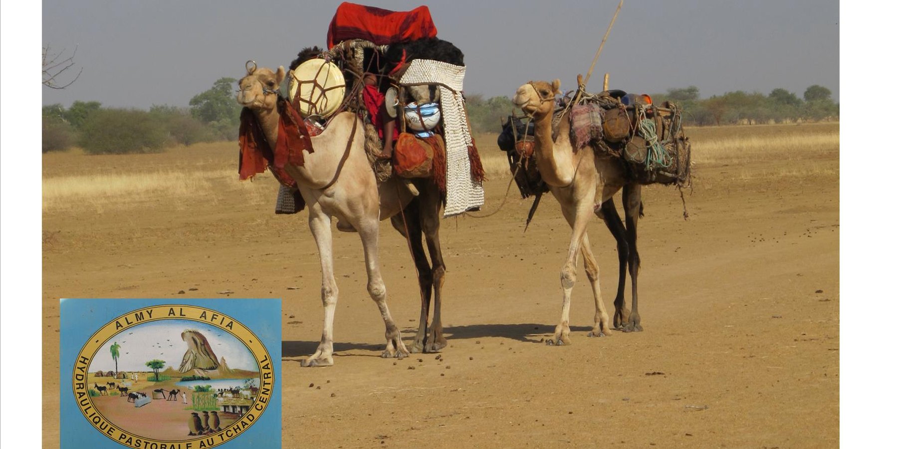
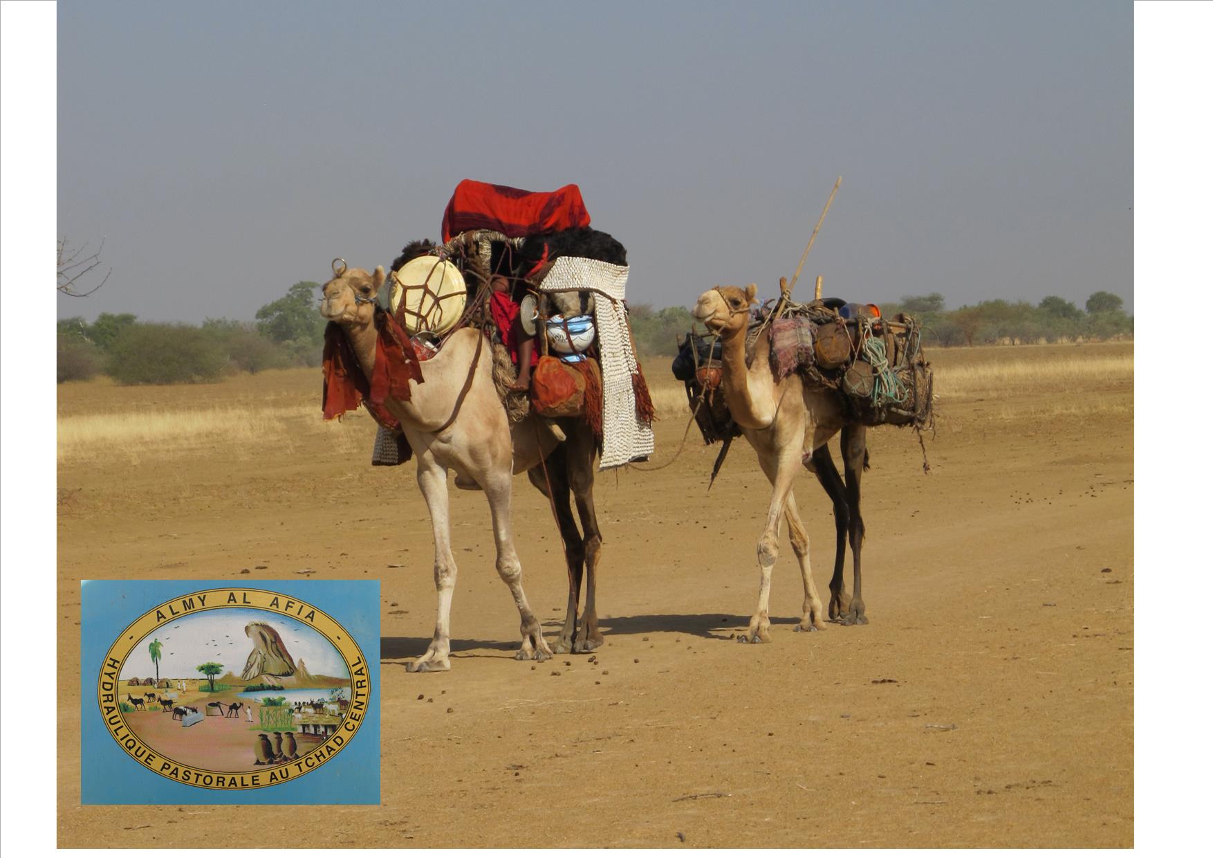
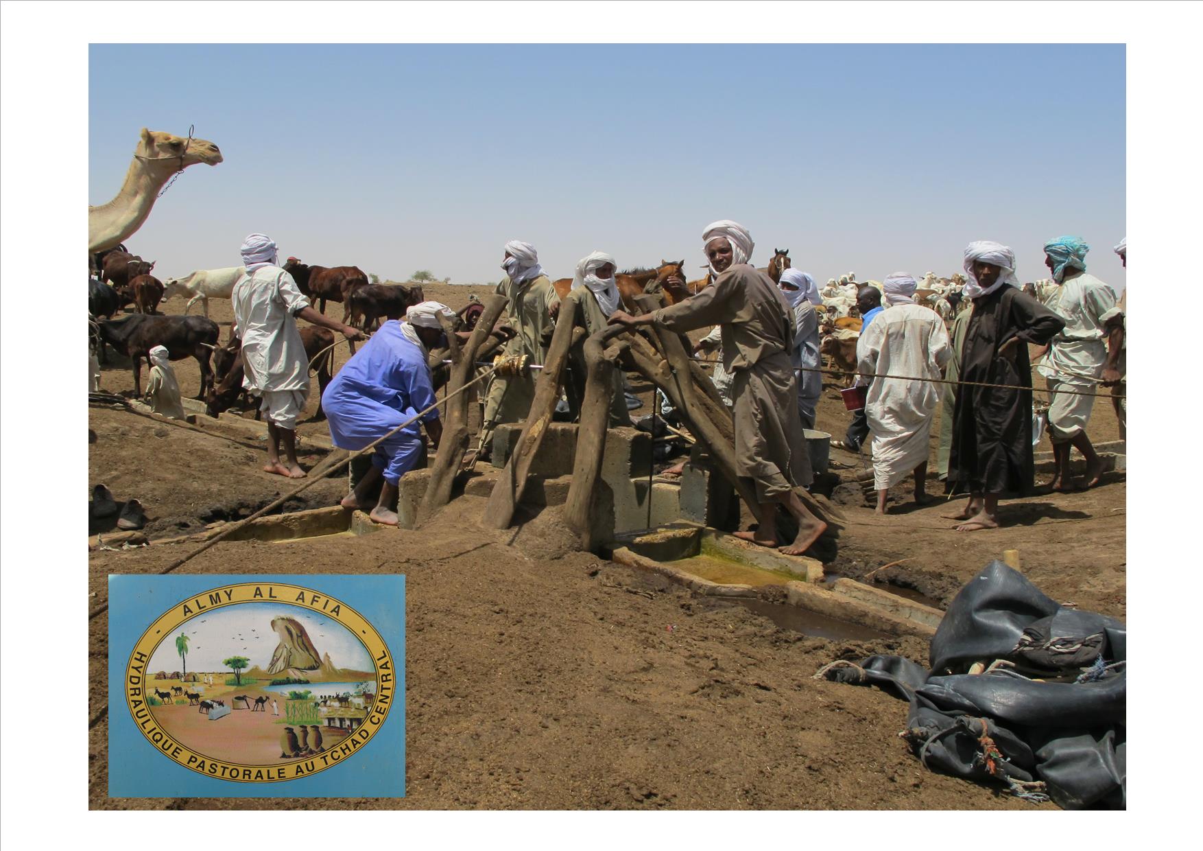
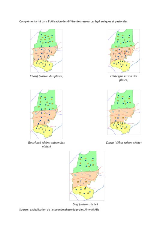
Livestock keeping is one of the main economic resources in Chad (in support of 40% of the population and 18% of the GDP, Ministry of Livestock, General census). Pastoralism in the country is based on the mobility of herds in a context of irregular precipitation and variable forage resources in time and space, and benefits from complementary relationships between the different ecological zones. In Chad, herds are taken in regular movements with the seasons between the Sahelian and the Sudanese grazing areas. The former are nutritious but limited in quantity, while the latter are more abundant but of lower quality, and not accessible until the fields are cleared after the harvest (meta-evaluation of projects on pastoral water sources, IIED, 2013). Thus, pastoral livestock keeping is founded on mobility and rangeland management, and on building complementary relationships and trade around farming systems and cultivated areas. The pastoralist systems are economically competitive (limited use of food inputs), and occur in marginal land which is characterized by conflicts, riots and a high level of insecurity (Conference of N'Djamena: 'Pastoral livestock keeping: a sustainable contribution to development and security in Saharan and Sahelian regions'). In the pastoral zone of Chad, where access to water is limited, the management and control of water sources by a social group in practice also leads to the monitoring and control of the use of grazing land which becomes available when water is present.
The project Almy Al Afia (2004-2016), developed by a partnership between the AFD and the Ministry of Water of Chad, operated in two regions of central Chad. The project Almy Al Afia was based on an entry 'development', concurrently with a process to consult and involve joint agencies. The project has improved approaches of preceding initiatives: concerted action and identification of water sources derived from the dialogue between users and authorities, and development of the local management of infrastructures and rangeland. The latter counteracts an exclusively private management or, instead, an ineffective public management which promotes free access to water sources and grazing land.
The project has enabled to address the following points:
1. Support mobility in pastoralism by enhancing the access to water (rehabilitation and construction of 160 wells; digging of 31 ponds for pastoral use);
2. Maintain or build processes of consultation and restoring security (joint committees for consultation and prevention of conflicts during transhumance);
3. Promote the proper use of water supply structures, in time and space (rehabilitated and new wells, excavated ponds) by context-specific management (strengthening of traditional management systems) and encourage the maintenance of infrastructure.
The pastoral ponds should be constructed in locations of existing water sources (natural ponds in suitable places, i.e. with a clayey soil capable to retain water). The existing water source is enlarged and improved by rural engineering (enlargement of the surface, deepening).
The wells are rehabilitated. Most wells were constructed several decades ago and are severely damaged. The water supply structures all have different and complementary functions. The deep wells in the pastoral zone are generally used throughout the year, and are overexploited. The way in which these structures are managed is strongly anchored in the region. The District officer delegates the management to 'Heads of Wells'. These old wells, which are used day and night, are often in a poor condition. Rehabilitating degraded wells is given priority over digging new wells because of the substantial potential for conflict. The water supply structures in areas of dry forest are less old and smaller in number. These wells are less frequently used and function as an alternative water source when the traditional ponds, water reservoirs and wells have dried up. They allow to delay the movement of the herds towards grazing areas in the Sahelian zone.
The strip between these two zones is used for agropastoralism. Herds cannot remain there. Therefore the project has facilitated the movement of the herds to the zones further south. The pastoral ponds close to the livestock routes for the transhumance were created in a way to be easily used by the herders, but also to encourage short stays.
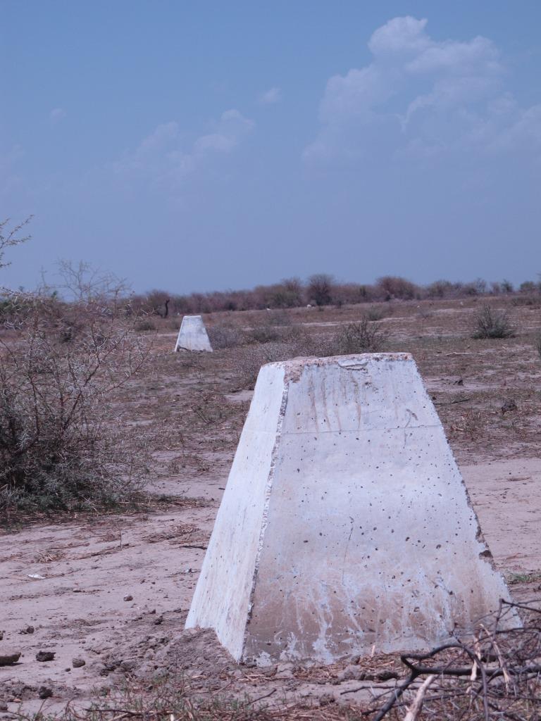
The approach was combined with consultation through joint committees for the prevention of conflicts, and at a later stage by marking of sections of the livestock routes for the transhumance. Many meetings were held with the users of the land management structures and policy makers, with the aim to identify and negotiate the target sites and to anticipate methods for the management and maintenance of the structures. This has enabled to maintain an atmosphere of social stability conducive to cooperation. Along almost 550 km of the livestock routes for the transhumance, sections were marked ('mourhals' in Chadian Arabic). The demarcation was not intended to enclose the herds in the livestock corridors (from which they can move freely outside the growing seasons for agricultural crops), but rather to implement the results of the consultations on the land use on the ground. The committees for the prevention of conflicts, which were supported by the project, also played a major role.
2.3 ຮູບພາບຂອງເຕັກໂນໂລຢີ
ສື່ຮູບພາບ
2.4 ວິດີໂອ ເຕັກໂນໂລຢີ
2.5 ປະເທດ / ເຂດ / ສະຖານທີ່ບ່ອນທີ່ ເຕັກໂນໂລຢີ ໄດ້ຮັບການນໍາໃຊ້ ແລະ ທີ່ຖືກປົກຄຸມດ້ວຍການປະເມີນຜົນ
ປະເທດ:
ເຈດ
ພາກພື້ນ / ລັດ / ແຂວງ:
Regions of Batha and of Guéra
ຂໍ້ມູນເພີ່ມເຕີມຂອງສະຖານທີ່:
Although the sites where the technology was applied are at the local scale, the project has considered pastoralism and the relationships between the two regions at the broader landscape scale.
ໃຫ້ລະບຸ ການແຜ່ຂະຫຍາຍ ເຕັກໂນໂລຢີ:
- ແຜ່ຂະຫຍາຍຢ່າງໄວວາໃນພື້ນທີ່
ຖ້າຫາກບໍ່ຮູ້ເນື້ອທີ່ທີ່ແນ່ນອນ, ໃຫ້ລະບຸ ເນື້ອທີ່ໂດຍປະມານ ທີ່ໃກ້ຄຽງ:
- 10-100 ກມ 2
ຄວາມຄິດເຫັນ:
Main towns of the two relevant regions (Ati for the region of Batha and Mongo for the region of Guéra).
The water sources constitute an anchorage point for the herds. The surrounding grazing land is controlled by the access to the water supply points (impact zone with a radius of 15 to 20 km around the wells). Apart from the area directly influenced by the technology, complementary relationships between the zones provide an added value: hence the zone targeted by the decision-making process of the herders is very large.
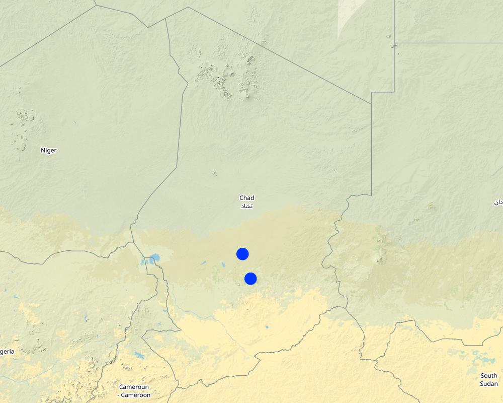
Map
×2.6 ວັນທີໃນການຈັດຕັ້ງປະຕິບັດ
ໃຫ້ລະບຸປີ ໃນການຈັດຕັ້ງປະຕິບັດ:
2018
2.7 ການນໍາສະເໜີ ເຕັກໂນໂລຢີ
ໃຫ້ລະບຸ ເຕັກໂນໂລຢີ ໄດ້ຖືກຈັດຕັ້ງປະຕິບັດຄືແນວໃດ?
- ໂດຍຜ່ານນະວັດຕະກໍາຄິດຄົ້ນຂອງຜູ້ນໍາໃຊ້ທີ່ດິນ
- ເປັນສ່ວນໜື່ງຂອງລະບົບພື້ນເມືອງ (>50 ປີ)
ຄວາມຄິດເຫັນ (ປະເພດ ໂຄງການ ແລະ ອື່ນໆ):
Projects on pastoral water resources like the project Almy Al Afia primarily focus on the development of water sources for pastoralism. The phases preceding the implementation are extremely important, because they are based on consultation and on the appreciation of local management systems. These phases include registration, selection of construction sites and the development of guidelines.
3. ການໃຈ້ແຍກ ເຕັກໂນໂລຢີ ໃນການຄຸ້ມຄອງ ດິນແບບຍືນຍົງ
3.1 ຈຸດປະສົງຫຼັກ (ຫຼາຍ) ຂອງເຕັກໂນໂລຢີ
- ຫຼຸດຜ່ອນ, ປ້ອງກັນ, ຟື້ນຟູ ການເຊື່ອມໂຊມຂອງດິນ
- ການອະນຸລັກ ລະບົບນິເວດ
- ປົກປັກຮັກສານໍ້າ / ນໍ້າພື້ນທີ່ - ປະສົມປະສານກັບ ເຕັກໂນໂລຢີອື່ນໆ
- ປົກປັກຮັກສາ / ການປັບປຸງຊີວະນາໆພັນ
- ຫຼຸດຜ່ອນຄວາມສ່ຽງ ທາງໄພພິບັດທໍາມະຊາດ
- ສ້າງຜົນກະທົບ ທາງເສດຖະກິດ ທີ່ເປັນປະໂຫຍດ
- ສ້າງຜົນກະທົບ ທີ່ເປັນທາງບວກ ໃຫ້ແກ່ສັງຄົມ
3.2 ປະເພດການນໍາໃຊ້ທີ່ດິນ ໃນປະຈຸບັນ() ທີ່ເຕັກໂນໂລຢີ ໄດ້ຖືກນໍາໃຊ້

ທົ່ງຫຍ້າລ້ຽງສັດ
ການລ້ຽງສັດແບບປ່ອຍ ຕາມທຳມະຊາດ:
- ແບບປ່ອຍ ຕາມທຳມະຊາດ
- ການລ້ຽງສັດແບບເຄີ່ງປ່ອຍ
ປະເພດສັດ:
- ອູດ
ຄວາມຄິດເຫັນ:
Number of growing seasons per year: 1
Livestock density: Variable depending on zones and seasons.
3.4 ການສະໜອງນ້ຳ
ການສະໜອງນໍ້າ ໃນພື້ນທີ່ ທີ່ໄດ້ນໍາໃຊ້ ເຕັກໂນໂລຢີ:
- ນໍ້າຝົນ
ຄວາມຄິດເຫັນ:
In these zones, rainfall is erratic in terms of spatial distribution and in quantity. Hence, grazing areas are not uniformly covered from year to year. The mobility of herds is the only way to adapt to this variability.
3.5 ການນໍາໃຊ້ເຕັກໂນໂລຢີ ທີ່ຢູ່ໃນກຸ່ມການຄຸ້ມຄອງ ທີ່ດິນແບບຍືນຍົງ
- ການຄຸ້ມຄອງສັດລ້ຽງ ແລະ ທົ່ງຫຍ້າລ້ຽງສັດ
- ການຈັດການນໍ້າໄຕ້ດິນ
3.6 ມາດຕະການ ການຄຸ້ມຄອງ ທີ່ດິນແບບຍືນຍົງ ປະກອບດ້ວຍ ເຕັກໂນໂລຢີ

ມາດຕະການໂຄງສ້າງ
- S8: ໂຄງສ້າງ ດ້ານສຸຂະອານາໄມ ຫຼື ການບໍາບັດສີ່ງເສດເຫຼືອ

ມາດຕະການ ທາງດ້ານການຄຸ້ມຄອງ
- M2: ການປ່ຽນແປງ ການຈັດການຄຸ້ມຄອງ / ລະດັບຄວາມໜາແໜ້ນ
- M3: ອີງຕາມສະພາບແວດລ້ອມ ທາງທຳມະຊາດ ແລະ ມະນຸດ
3.7 ປະເພດດິນເຊື່ອມໂຊມ ຫຼັກທີ່ໄດ້ນໍາໃຊ້ ເຕັກໂນໂລຢີ

ດິນເຊາະເຈື່ອນ ໂດຍນໍ້າ
- Wt: ການສູນເສຍຊັ້ນໜ້າດິນ / ການເຊາະເຈື່ອນຜິວໜ້າດິນ

ດິນເຊາະເຈື່ອນ ໂດຍລົມ
- ການສູນເສຍຊັ້ນໜ້າດິນ
- Eo: ຜົນກະທົບຈາກການເຊື່ອມໂຊມທາງອ້ອມ

ການເຊື່ອມໂຊມ ຂອງດິນ ທາງກາຍະພາບ
- Ps: ຊຸດຂອງດິນອົງຄະທາດ, ການຕັ້ງຖິ່ນຖານຂອງດິນ

ການເຊື່ອມໂຊມ ທາງຊີວະພາບ
- Bc: ການຫຼຸດຜ່ອນການປົກຫຸ້ມຂອງພືດ
- Bq: ປະລິມານ / ອິນຊີວັດຖຸຫຼຸດລົງ

ການເຊື່ອມໂຊມ ຂອງນໍ້າ
- Hs: ການປ່ຽນແປງ ປະລິມານ ນໍ້າໜ້າດິນ
- Hg: ການປ່ຽນແປງ ລະດັບນ້ຳໃຕ້ດິນ ຫຼື ນ້ຳບາດານ
- Hp: ຄຸນນະພາບ ຂອງນ້ຳຊັ້ນໜ້າດິນຫຼຸດລົງ
- Hq: ຄຸນນະພາບ ຂອງນ້ຳໃຕ້ດິນຫຼຸດລົງ
3.8 ການປ້ອງກັນ, ການຫຼຸດຜ່ອນ, ຫຼືການຟື້ນຟູຂອງການເຊື່ອມໂຊມຂອງດິນ
ໃຫ້ລະບຸ ເປົ້າໝາຍ ເຕັກໂນໂລຢີ ທີ່ພົວພັນ ກັບຄວາມເຊື່ອມໂຊມຂອງດິນ:
- ປ້ອງກັນການເຊື່ອມໂຊມຂອງດິນ
- ຫຼຸດຜ່ອນການເຊື່ອມໂຊມຂອງດິນ
4. ຂໍ້ກໍາໜົດ, ກິດຈະກໍາການປະຕິບັດ, ວັດຖຸດິບ, ແລະຄ່າໃຊ້ຈ່າຍ
4.1 ເຕັກນິກ ໃນການແຕ້ມແຜນວາດ ເຕັກໂນໂລຢີ
ຄຸນລັກສະນະ ຂອງເຕັກນິກ (ທີ່ກ່ຽວຂ້ອງ ກັບການແຕ້ມແຜນວາດ ທາງດ້ານເຕັກນີກ):
The wells (new and rehabilitated) and the demarcation of the livestock routes are the outcome of a long process of outreach. The communications between the local level (taking account of the views of future users) and the level of decision-making (administration) enable social agreements to be formalized. These agreements set the rules for the selection of the locations of the water supply structures, their management and maintenance.
ຜູ້ຂຽນ:
Project Almy Al Afia
ວັນທີ:
2016
4.2 ຂໍ້ມູນທົ່ວໄປກ່ຽວກັບການຄິດໄລ່ປັດໃຈຂາເຂົ້າໃນການຜະລິດ ແລະ ມູນຄ່າອື່ນໆ
ລະບຸ ວິທີການ ຄຳໃຊ້ຈ່າຍ ແລະ ປັດໄຈນໍາເຂົ້າ ທີ່ໄດ້ຄິດໄລ່:
- ຕໍ່ຫົວໜ່ວຍ ທີ່ໄດ້ຈັດຕັ້ງປະຕິບັດ ເຕັກໂນໂລຢີ
ໃຫ້ລະບຸຫົວໜ່ວຍ:
Structure (new well, rehabilitation or km of markings)
ສະກຸນເງິນອື່ນໆ / ປະເທດອື່ນໆ (ລະບຸ):
FCFA
ລະບຸ ຄ່າຈ້າງ ຄ່າແຮງງານສະເລ່ຍ ຕໍ່ ວັນ:
1000 FCFA
4.3 ການສ້າງຕັ້ງກິດຈະກໍາ
| ກິດຈະກໍາ | Timing (season) | |
|---|---|---|
| 1. | Outreach / awareness raising | Four to six meetings prior to the signing of the social agreements |
| 2. | Construction of the facilities | Four to six months, depending on the type of structure and its depth |
| 3. | Monitoring the management | Regular visits of the project team to support the implementation of adapted management practices |
ຄວາມຄິດເຫັນ:
The implementation of the different phases varies greatly in terms of the location of the outreach activities and the duration of the construction work.
4.4 ຕົ້ນທຶນ ແລະ ປັດໄຈຂາເຂົ້າທີ່ຈໍາເປັນໃນຈັດຕັ້ງປະຕິບັດ
| ລະບຸ ປັດໃຈ ນໍາເຂົ້າ ໃນການຜະລີດ | ຫົວໜ່ວຍ | ປະລິມານ | ຕົ້ນທຶນ ຕໍ່ຫົວໜ່ວຍ | ຕົ້ນທຶນທັງໝົດ ຂອງປັດໃຈຂາເຂົ້າ ໃນການຜະລິດ | % ຂອງຕົ້ນທຶນທັງໝົດ ທີ່ຜູ້ນໍາໃຊ້ທີ່ດິນ ໃຊ້ຈ່າຍເອງ | |
|---|---|---|---|---|---|---|
| ວັດສະດຸກໍ່ສ້າງ | Rehabilitated wells (mean depth 56 m) | 1 | 93.0 | 10497939.0 | 976308327.0 | |
| ວັດສະດຸກໍ່ສ້າງ | Geophysical assessment for new wells | 1 | 158.0 | 17979914.0 | 2840826412.0 | |
| ວັດສະດຸກໍ່ສ້າງ | Exploration drilling for new wells (mean depth 96 m) | 1 | 220.0 | 6005415.0 | 1321191300.0 | |
| ວັດສະດຸກໍ່ສ້າງ | New wells (mean depth 45 m) | 1 | 62.0 | 45145740.0 | 2799035880.0 | |
| ວັດສະດຸກໍ່ສ້າງ | Pastoral ponds (6000 m3 on average) | 1 | 31.0 | 23008065.0 | 713250015.0 | |
| ວັດສະດຸກໍ່ສ້າງ | Markers (8 signs / km) | 1 | 492.0 | 1069203.0 | 526047876.0 | |
| ອື່ນໆ | Outreach on new wells (/site) | 1 | 62.0 | 213428.0 | 13232536.0 | |
| ອື່ນໆ | Outreach on rehabilitation (/site) | 1 | 93.0 | 248695.0 | 23128635.0 | |
| ອື່ນໆ | Outreach on marking (/km) | 1 | 492.0 | 52088.0 | 25627296.0 | |
| ອື່ນໆ | None | None | ||||
| ຕົ້ນທຶນທັງໝົດ ໃນການຈັດຕັ້ງປະຕິບັດ ເຕັກໂນໂລຢີ | 9238648277.0 | |||||
| ຄ່າໃຊ້ຈ່າຍທັງໝົດ ສຳລັບການສ້າງຕັ້ງເຕັກໂນໂລຢີ ເປັນສະກຸນເງີນໂດລາ | 9238648277.0 | |||||
ຄວາມຄິດເຫັນ:
The context of pastoralism has taken the project approach to not ask compensation from users: if the users are never the same, then who should be charged? Who will collect the payments and manage the collected funds? In addition, most of the water supply structures are far from financial institutions, which causes problems in securing these funds. Therefore the users contribute in terms of day-to-day maintenance of structures, by mobilizing labour in particular.
4.5 ບໍາລຸງຮັກສາ / ແຜນຈັດຕັ້ງປະຕິບັດ ກິດຈະກໍາ
| ກິດຈະກໍາ | ໄລຍະເວລາ / ຄວາມຖີ່ | |
|---|---|---|
| 1. | Mobilising indigenous groups for day-to-day maintenance of structures (dredging, cleaning) | Depending on the type of structure (generally monthly) |
4.6 ຄ່າໃຊ້ຈ່າຍ ແລະ ປັດໄຈນໍາເຂົ້າທີ່ຈໍາເປັນສໍາລັບການບໍາລຸງຮັກສາກິດຈະກໍາ / ແຜນປະຕິບັດ (ຕໍ່ປີ)
| ລະບຸ ປັດໃຈ ນໍາເຂົ້າ ໃນການຜະລີດ | ຫົວໜ່ວຍ | ປະລິມານ | ຕົ້ນທຶນ ຕໍ່ຫົວໜ່ວຍ | ຕົ້ນທຶນທັງໝົດ ຂອງປັດໃຈຂາເຂົ້າ ໃນການຜະລິດ | % ຂອງຕົ້ນທຶນທັງໝົດ ທີ່ຜູ້ນໍາໃຊ້ທີ່ດິນ ໃຊ້ຈ່າຍເອງ | |
|---|---|---|---|---|---|---|
| ແຮງງານ | Support missions for the management and maintenance of the water supply structures (2 missions per structure for the entire project) | 1 | 155.0 | 53000.0 | 8215000.0 | |
| ແຮງງານ | Support mission for the management and maintenance of the markings | 1 | 100.0 | 53000.0 | 5300000.0 | |
| ຕົ້ນທຶນທັງໝົດ ທີ່ໃຊ້ໃນການບໍາລຸງຮັກສາ ເຕັກໂນໂລຢີ | 13515000.0 | |||||
| ຄ່າໃຊ້ຈ່າຍທັງໝົດ ສຳລັບການບົວລະບັດຮກສາເຕັກໂນໂລຢີ ເປັນສະກຸນເງີນໂດລາ | 13515000.0 | |||||
ຄວາມຄິດເຫັນ:
The amount of financial support varied with the type of structure (more support for management and maintenance is needed for new structures than for rehabilitated structures) and with their location or specific problem (in the case of structures located in the agropastoral zones). Financial support to the markings of the livestock corridors was indirectly provided through the committees for the prevention and management of conflicts.
4.7 ປັດໄຈ ທີ່ສໍາຄັນ ທີ່ສົ່ງຜົນກະທົບ ຕໍ່ຄ່າໃຊ້ຈ່າຍ
ໃຫ້ອະທິບາຍ ປັດໃຈ ທີ່ສົ່ງຜົນກະທົບ ຕໍ່ຕົ້ນທຶນ ໃນການຈັດຕັ້ງປະຕິບັດ:
The costs of the constructions are highly dependent on their location (costs for the supply and disposal of equipment and materials), on the price of inputs (cement, etc.), and especially on the type of structure (depth of the wells, geological environment). The costs of the supply and disposal of equipment and materials include costs for the installation of the structures (water, cement, labour, machinery) on the construction sites (which are often far away from routes and towns), and costs for the disposal of the equipment after the construction is completed. The costs of supply and disposal can be significant with respect to the costs of the structure itself.
5. ສະພາບແວດລ້ອມທໍາມະຊາດ ແລະ ມະນຸດ
5.1 ອາກາດ
ປະລິມານນໍ້າຝົນປະຈໍາປີ
- < 250 ມີລິແມັດ
- 251-500 ມີລິແມັດ
- 501-750 ມີລິແມັດ
- 751-1,000 ມີລິແມັດ
- 1,001-1,500 ມີລິແມັດ
- 1,501-2,000 ມີລິແມັດ
- 2,001-3,000 ມີລິແມັດ
- 3,001-4,000 ມີລິແມັດ
- > 4,000 ມີລິແມັດ
ຂໍ້ມູນສະເພາະ / ຄວາມເຫັນກ່ຽວກັບ ປະລິມານນໍ້າຝົນ:
One rainy season per year (from June to September)
ໃຫ້ລະບຸ ຊື່ສະຖານີ ອຸຕຸນິຍົມ ເພື່ອເປັນຂໍ້ມູນອ້າງອີງ:
Ati
ເຂດສະພາບອາກາດກະສິກໍາ
- ເຄິ່ງແຫ້ງແລ້ງ
- ແຫ້ງແລ້ງ
The target region includes large areas extending over important gradients (encompassing boundaries of the desert zone, the forested zone and the cotton-growing zone).
5.2 ພູມິປະເທດ
ຄ່າສະເລ່ຍ ຄວາມຄ້ອຍຊັນ:
- ພື້ນທີ່ຮາບພຽງ (0-2%)
- ອ່ອນ (3-5 %)
- ປານກາງ (6-10 %)
- ມ້ວນ (11-15 %)
- ເນີນ(16-30%)
- ໍຊັນ (31-60%)
- ຊັນຫຼາຍ (>60%)
ຮູບແບບຂອງດິນ:
- ພູພຽງ / ທົ່ງພຽງ
- ສັນພູ
- ເປີ້ນພູ
- ເນີນພູ
- ຕີນພູ
- ຮ່ອມພູ
ເຂດລະດັບສູງ:
- 0-100 ແມັດ a.s.l.
- 101-500 ແມັດ a.s.l.
- 501-1,000 ແມັດ a.s.l.
- 1,001-1,500 ແມັດ a.s.l.
- 1,501-2,000 ແມັດ a.s.l.
- 2,001-2,500 ແມັດ a.s.l.
- 2,501-3,000 ແມັດ a.s.l.
- 3,001-4,000 ແມັດ a.s.l.
- > 4,000 ແມັດ a.s.l.
ໃຫ້ລະບຸ ເຕັກໂນໂລຢີ ທີ່ໄດ້ຖືກນຳໃຊ້:
- ບໍ່ກ່ຽວຂ້ອງ
5.3 ດິນ
ຄວາມເລິກ ຂອງດິນສະເລ່ຍ:
- ຕື້ນຫຼາຍ (0-20 ຊັງຕີແມັດ)
- ຕື້ນ (21-50 ຊຕມ)
- ເລີກປານກາງ (51-80 ຊຕມ)
- ເລິກ (81-120 ຊມ)
- ເລິກຫຼາຍ (> 120 cm)
ເນື້ອດິນ (ໜ້າດິນ):
- ຫຍາບ / ເບົາ (ດິນຊາຍ)
ເນື້ອດິນ (ເລິກຈາກໜ້າດິນ ລົງໄປຫຼາຍກວ່າ 20 ຊັງຕິແມັດ):
- ຫຍາບ / ເບົາ (ດິນຊາຍ)
ຊັ້ນອິນຊີວັດຖຸ ເທິງໜ້າດິນ:
- ຕໍາ່ (<1 %)
5.4 ມີນໍ້າ ແລະ ຄຸນນະພາບ
ລະດັບ ນໍ້າໃຕ້ດິນ:
> 50 ແມັດ
ການມີນໍ້າ ເທິງໜ້າດິນ:
ທຸກຍາກ / ບໍ່ມີ
ຄຸນນະພາບນໍ້າ (ບໍ່ມີການບໍາບັດ):
ມີນໍ້າດື່ມ
ມີບັນຫາ ກ່ຽວກັບນໍ້າເຄັມບໍ່?
ແມ່ນ
ລະບຸ ຊະນິດ:
Depending on the zones: presence of sodium carbonate.
ເກີດມີນໍ້າຖ້ວມ ໃນພື້ນທີ່ບໍ່?
ບໍ່ແມ່ນ
5.5 ຊີວະນາໆພັນ
ຄວາມຫຼາກຫຼາຍ ທາງສາຍພັນ:
- ປານກາງ
ຄວາມຫຼາກຫຼາຍ ທາງດ້ານ ທີ່ຢູ່ອາໃສ ຂອງສິ່ງທີ່ມີຊີວິດ:
- ປານກາງ
5.6 ຄຸນລັກສະນະ ຂອງຜູ້ນໍາໃຊ້ທີ່ດິນ ທີ່ໄດ້ນໍາໃຊ້ເຕັກໂນໂລຢີ
ຢູ່ປະຈຳ ຫຼື ເຄື່ອນຍ້າຍຕະຫຼອດ:
- ແບບເຄີ່ງຂັງ-ເຄີ່ງປ່ອຍ
- ແບບປ່ອຍຕາມທຳມະຊາດ
ລະບົບ ການຕະຫຼາດ ແລະ ຜົນຜະລິດ:
- ປະສົມປົນເປ( ກຸ້ມຕົນເອງ/ເປັນສິນຄ້າ)
ລາຍຮັບ ທີ່ບໍ່ໄດ້ມາຈາກ ການຜະລິດ ກະສິກໍາ:
- ໜ້ອຍກ່ວາ 10 % ຂອງລາຍຮັບທັງໝົດ
ລະດັບຄວາມຮັ່ງມີ:
- ທຸກຍາກຫຼາຍ
- ທຸກຍາກ
ບຸກຄົນ ຫຼື ກຸ່ມ:
- ກຸ່ມ / ຊຸມຊົນ
ລະດັບ ການຫັນເປັນກົນຈັກ:
- ການໃຊ້ແຮງງານຄົນ
ເພດ:
- ຜູ້ຍິງ
- ຜູ້ຊາຍ
ອາຍຸ ຂອງຜູ້ນໍາໃຊ້ທີ່ດິນ:
- ຊາວໜຸ່ມ
- ໄວກາງຄົນ
5.7 ເນື້ອທີ່ສະເລ່ຍຂອງດິນ ທີ່ຜູ້ນຳໃຊ້ທີ່ດິນ ໃຊ້ເຮັດເຕັກໂນໂລຢີ
- <0.5 ເຮັກຕາ
- 0.5-1 ເຮັກຕາ
- 1-2 ເຮັກຕາ
- 2-5 ເຮັກຕາ
- 5-15 ເຮັກຕາ
- 15-50 ເຮັກຕາ
- 50-100 ເຮັກຕາ
- 100-500 ເຮັກຕາ
- 500-1,000 ເຮັກຕາ
- 1,000-10,000 ເຮັກຕາ
- > 10,000 ເຮັກຕາ
ຖືໄດ້ວ່າ ເປັນຂະໜາດນ້ອຍ, ກາງ ຫຼື ໃຫຍ່ (ອີງຕາມເງື່ອນໄຂ ສະພາບຄວາມເປັນຈິງ ຂອງທ້ອງຖີ່ນ)? :
- ຂະໜາດໃຫຍ່
ຄວາມຄິດເຫັນ:
Transhumance, and more generally pastoral mobility, applies to large geographical scales and long periods. The areas involved are very large, far above 10.000 ha.
5.8 ເຈົ້າຂອງທີ່ດິນ, ສິດໃຊ້ທີ່ດິນ, ແລະ ສິດທິການນໍາໃຊ້ນໍ້າ
ເຈົ້າຂອງດິນ:
- ກຸ່ມ
ສິດທິ ໃນການນໍາໃຊ້ທີ່ດິນ:
- ຊຸມຊົນ (ທີ່ມີການຈັດຕັ້ງ)
ສິດທິ ໃນການນໍາໃຊ້ນໍ້າ:
- ຊຸມຊົນ (ທີ່ມີການຈັດຕັ້ງ)
5.9 ການເຂົ້າເຖິງການບໍລິການ ແລະ ພື້ນຖານໂຄງລ່າງ
ສຸຂະພາບ:
- ທຸກຍາກ
- ປານກາງ
- ດີ
ການສຶກສາ:
- ທຸກຍາກ
- ປານກາງ
- ດີ
ການຊ່ວຍເຫຼືອ ດ້ານວິຊາການ:
- ທຸກຍາກ
- ປານກາງ
- ດີ
ການຈ້າງງານ (ຕົວຢ່າງ, ການເຮັດກິດຈະກໍາອື່ນ ທີ່ບໍ່ແມ່ນ ການຜະລິດກະສິກໍາ):
- ທຸກຍາກ
- ປານກາງ
- ດີ
ຕະຫຼາດ:
- ທຸກຍາກ
- ປານກາງ
- ດີ
ພະລັງງານ:
- ທຸກຍາກ
- ປານກາງ
- ດີ
ຖະໜົນຫົນທາງ ແລະ ການຂົນສົ່ງ:
- ທຸກຍາກ
- ປານກາງ
- ດີ
ການດື່ມນໍ້າ ແລະ ສຸຂາພິບານ:
- ທຸກຍາກ
- ປານກາງ
- ດີ
ການບໍລິການ ທາງດ້ານການເງິນ:
- ທຸກຍາກ
- ປານກາງ
- ດີ
6. ຜົນກະທົບ ແລະ ລາຍງານສະຫຼຸບ
6.1 ການສະແດງຜົນກະທົບ ພາຍໃນພື້ນທີ່ ທີ່ໄດ້ຈັດຕັ້ງປະຕິບັດ ເຕັກໂນໂລຢີ
ຜົນກະທົບທາງເສດຖະກິດສັງຄົມ
ມີນໍ້າ ແລະ ຄຸນນະພາບ
ມີນໍ້າ ໃຫ້ສັດລ້ຽງ
ປະລິມານ ກ່ອນການຈັດຕັ້ງປະຕິບັດ ການຄຸ້ມຄອງ ທີ່ດິນແບບຍືນຍົງ:
n/a
ປະລີມານ ຫຼັງການຈັດຕັ້ງປະຕິບັດ ການຄຸ້ມຄອງ ທີ່ດິນແບບຍືນຍົງ:
n/a
ຄວາມຄິດເຫັນ / ລະບຸແຈ້ງ:
Expansion of the areas covered by water supply points. Reduced closure of water supply points (rehabilitation), opening-up of new grazing land, securing the movement of livestock and people.
ຄຸນນະພາບ ຂອງນໍ້າ ສໍາລັບລ້ຽງສັດ
ປະລິມານ ກ່ອນການຈັດຕັ້ງປະຕິບັດ ການຄຸ້ມຄອງ ທີ່ດິນແບບຍືນຍົງ:
n/a
ປະລີມານ ຫຼັງການຈັດຕັ້ງປະຕິບັດ ການຄຸ້ມຄອງ ທີ່ດິນແບບຍືນຍົງ:
n/a
ຜົນກະທົບດ້ານວັດທະນາທໍາສັງຄົມ
ການຄໍ້າປະກັນ ສະບຽງອາຫານ / ກຸ້ມຢູ່ກຸ້ມກິນ
ຄວາມຄິດເຫັນ / ລະບຸແຈ້ງ:
Preserving the capacity of herders and their families to move, to choose their trajectories rather than responding to imposed conditions.
ສິດທິ ໃນການນໍາໃຊ້ທີ່ດິນ ຫຼື ນໍ້າ
ປະລິມານ ກ່ອນການຈັດຕັ້ງປະຕິບັດ ການຄຸ້ມຄອງ ທີ່ດິນແບບຍືນຍົງ:
n/a
ປະລີມານ ຫຼັງການຈັດຕັ້ງປະຕິບັດ ການຄຸ້ມຄອງ ທີ່ດິນແບບຍືນຍົງ:
n/a
ຄວາມຄິດເຫັນ / ລະບຸແຈ້ງ:
Upgrading of traditional management systems of water supply structures.
ສະຖາບັນ ການຈັດຕັ້ງຊຸມຊົນ
ການຫຼຸດຜ່ອນ ຂໍ້ຂັດແຍ່ງ
ສະຖານະການຂອງສັງຄົມ ແລະ ກຸ່ມດ້ອຍໂອກາດທາງເສດຖະກິດ
ຜົນກະທົບຕໍ່ລະບົບນິເວດ
ດິນ
ການປົກຄຸມຂອງດິນ
ຄວາມຄິດເຫັນ / ລະບຸແຈ້ງ:
Reduction of the impacts of the concentration of livestock and people in small areas. Promotes the complementary relations between the zones (pressure relief in some zones and use and maintenance of other zones), and over the seasons.
ອິນຊີວັດຖຸໃນດິນ / ຢູ່ລຸ່ມຊັ້ນດິນ C
ຊີວະນານາພັນ: ສັດ, ພືດ
ການປົກຫຸ້ມຂອງພືດ
ຄວາມຫຼາກຫຼາຍຂອງພືດ
ການຫຼຸດຜ່ອນ ຄວາມສ່ຽງ ຈາກໄພພິບັດ ແລະ ອາກາດປ່ຽນແປງ
ຜົນກະທົບ ຂອງໄພແຫ້ງແລ້ງ
6.2 ຜົນກະທົບທາງອ້ອມ ຈາກການນໍາໃຊ້ເຕັກໂນໂລຢີ
ສາມາດເຂົ້າເຖິງແຫຼ່ງນໍ້າ
ປະລິມານ ກ່ອນການຈັດຕັ້ງປະຕິບັດ ການຄຸ້ມຄອງ ທີ່ດິນແບບຍືນຍົງ:
n/a
ປະລີມານ ຫຼັງການຈັດຕັ້ງປະຕິບັດ ການຄຸ້ມຄອງ ທີ່ດິນແບບຍືນຍົງ:
n/a
ຄວາມຄິດເຫັນ / ລະບຸແຈ້ງ:
Increased access to groundwater through the rehabilitation of wells and the construction of new wells.
ກໍານົດ ການປະເມີນ ຜົນກະທົບທາງນອກ (ການວັດແທກ):
As explained above, in these zones with low rainfall and scarce natural water sources of temporary character (ponds), it is essential to combine the use of surface water with the use of water from deep permanent groundwater bodies. When they have the choice, herders almost exclusively choose sources with surface water (avoiding effort to extract the water). But when these sources run dry, they fall back on using wells (and deep groundwater). The rehabilitation of old wells and the construction of new wells in zones without wells contributes to increasing the availability of water.
6.3 ການປ້ອງກັນ ແລະ ຄວາມບອບບາງ ຂອງເຕັກໂນໂລຢິ ໃນການປ່ຽນແປງສະພາບດິນຟ້າອາກາດ ແລະ ກ່ຽວຂ້ອງກັບອາກາດທີ່ມີການປ່ຽນແປງທີ່ຮຸນແຮງ / ໄພພິບັດທາງທໍາມະຊາດ (ຮັບຮູ້ໄດ້ໂດຍຜູ້ນໍາໃຊ້ທີ່ດິນ)
ການປ່ຽນແປງດິນຟ້າອາກາດ ເທື່ອລະກ້າວ
ການປ່ຽນແປງດິນຟ້າອາກາດ ເທື່ອລະກ້າວ
| ລະດູການ | ເພີ່ມຂື້ນ ຫຼື ຫຼຸດລົງ | ການນໍາໃຊ້ ເຕັກໂນໂລຢີ ສາມາດ ຮັບມື ໄດ້ຄືແນວໃດ? | |
|---|---|---|---|
| ປະລິມານນໍ້າຝົນປະຈໍາປີ | ຫຼຸດລົງ | ບໍ່ດີ | |
| ປະລິມານນໍ້າຝົນຕາມລະດູການ | ຄວາມຊຸ່ມ / ລະດູຝົນ | ຫຼຸດລົງ | ບໍ່ດີ |
ອາກາດ ທີ່ກ່ຽວພັນກັບຄວາມຮຸນແຮງ (ໄພພິບັດທາງທໍາມະຊາດ)
ໄພພິບັດທາງພູມອາກາດ
| ການນໍາໃຊ້ ເຕັກໂນໂລຢີ ສາມາດ ຮັບມື ໄດ້ຄືແນວໃດ? | |
|---|---|
| ແຫ້ງແລ້ງ | ດີ |
6.4 ການວິເຄາະຕົ້ນທຶນ ແລະ ຜົນປະໂຫຍດ
ຈະເຮັດປະໂຫຍດເພື່ອປຽບທຽບກັບຄ່າໃຊ້ຈ່າຍກັບສິ່ງກໍ່ສ້າງ (ຈາກທັດສະນະຂອງຜູ້ນຳໃຊ້ທີ່ດິນ) ໄດ້ແນວໃດ?
ຜົນຕອບແທນ ໃນໄລຍະສັ້ນ:
ຜົນກະທົບທາງບວກ
ຜົນຕອບແທນ ໃນໄລຍະຍາວ:
ຜົນກະທົບທາງບວກຫຼາຍ
ຈະໄດ້ຮັບຜົນປະໂຫຍດເມື່ອປຽບທຽບກັບ / ຄ່າໃຊ້ຈ່າຍໃນການບຳລຸງຮັກສາທີເ່ກີດຂື້ນອິກ (ຈາກທັດສະນະຄະຕິຂອງຜູ້ນຳໃຊ້ທີ່ດິນ) ໄດ້ແນວໃດ?
ຜົນຕອບແທນ ໃນໄລຍະສັ້ນ:
ຜົນກະທົບທາງບວກ
ຜົນຕອບແທນ ໃນໄລຍະຍາວ:
ຜົນກະທົບທາງບວກ
ຄວາມຄິດເຫັນ:
The profitability is considered in relation to the number of animals/herds involved. The costs of construction and rehabilitation are certainly significant, but the water supply structures are used for thousands of animals (in case of the most heavily used wells); most animals drink every two days. Therefore the costs per head of livestock are limited. The wells are long lasting, and therefore the returns are positive in the short and the long term.
6.5 ການປັບຕົວຮັບເອົາເຕັກໂນໂລຢີ
- > 50%
ຖ້າຫາກວ່າມີ, ປະລິມານ (ຈໍານວນຂອງຄົວເຮືອນ / ເນື້ອທີ່ການຄຸ້ມຄອງ):
The technology responds to a substantial need, but also corresponds to the capacity of land users to use and maintain the structures. The energy supply is provided by animal traction, and does not require external energy sources.
ທັງໝົດນັ້ນ ແມ່ນໃຜ ໄດ້ປັບຕົວເຂົ້າ ໃນການນໍາໃຊ້ ເຕັກໂນໂລຢີ, ມີຈັກຄົນ ທີ່ສາມາດເຮັດເອງໄດ້, ຕົວຢ່າງ, ປາດສະຈາກ ການຊ່ວຍເຫຼືອ ທາງດ້ານອຸປະກອນ / ການຈ່າຍເປັນເງິນ?
- 91-100%
ຄວາມຄິດເຫັນ:
Access to water is such a large problem that it requires all the land users who enter the zone to be informed when a water supply structure is rehabilitated or constructed. The involvement of traditional leaders in the management of the structures, and the system of representatives of the traditional leadership in the various other zones (Khalifas) contributes to the spontaneous dissemination of the information.
6.6 ການປັບຕົວ
ໄດ້ມີການດັດປັບ ເຕັກໂນໂລຢີ ເພື່ອໃຫ້ແທດເໝາະກັບເງື່ອນໄຂ ການປ່ຽນແປງບໍ?
ບໍ່ແມ່ນ
6.7 ຈຸດແຂງ / ຂໍ້ດີ / ໂອກາດ ໃນການນໍາໃຊ້ ເຕັກໂນໂລຢີ
| ຈຸດແຂງ / ຂໍ້ດີ / ໂອກາດໃນການນໍາໃຊ້ທີ່ດິນ |
|---|
| Permanent access to water. |
| Reopening of water supply structures and consolidation of access to water at some degraded sites. |
| Agencies and authorities for conflict prevention. |
| Marking of sections of livestock corridors with conflict situations. |
| ຈຸດແຂງ / ຈຸດດີ / ໂອກາດ ຈາກທັດສະນະຂອງຜູ້ປ້ອນຂໍ້ມູນ ຫຼື ບຸກຄົນສຳຄັນ |
|---|
| Full commitment of groups (access to water is a major problem). |
| Continuation of the approach through the development of other projects and inclusion at the national level. |
6.8 ຈຸດອ່ອນ / ຂໍ້ເສຍ / ຄວາມສ່ຽງ ໃນການນໍາໃຊ້ ເຕັກໂນໂລຢີ ແລະ ວິທີການແກ້ໄຂບັນຫາ
| ຈຸດອ່ອນ / ຂໍ້ເສຍ / ຄວາມສ່ຽງໃນມຸມມອງຂອງຜູ້ນໍາໃຊ້ທີ່ດິນ | ມີວິທີການແກ້ໄຂຄືແນວໃດ? |
|---|---|
| Interventions are limited with regard to the needs (rehabilitation in particular). | By larger investments and better integration of the approach in public action. |
| There is a need to extend the approach, in particular the support to the consultative bodies. | Formalize support to the consultation process. |
| ຈຸດອ່ອນ/ຂໍ້ບົກຜ່ອງ/ຄວາມສ່ຽງ ຈາກທັດສະນະຂອງຜູ້ປ້ອນຂໍ້ມູນ ຫຼື ບຸກຄົນສຳຄັນ | ມີວິທີການແກ້ໄຂຄືແນວໃດ? |
|---|---|
|
Recognition of the experiences, the approach and the methodology in other interventions. Outreach and awareness raising are performed during the project, but at the end the management of the infrastructure is no longer supported. The government should be able to follow up on the support (mechanism for monitoring and maintenance). |
Formalize support to the consultation process. |
| There is a need to mainstream outreach and consultation (lengthy process). | Formalize support to the consultation process. |
7. ເອກະສານອ້າງອີງ ແລະ ການເຊື່ອມຕໍ່
7.1 ວິທີການ / ແຫຼ່ງຂໍ້ມູນ
- ການໄປຢ້ຽມຢາມພາກສະໜາມ, ການສໍາຫຼວດພາກສະໜາມ
Progress reports and thematic reports of the project Almy Al Afia
- ການສໍາພາດ ຜູ້ນໍາໃຊ້ທີ່ດິນ
Follow-up and evaluation of the project activities (logbook, annual update)
- ການລວບລວມ ບົດລາຍງານ ແລະ ເອກະສານ ອື່ນໆ ທີ່ມີຢູ່ແລ້ວ
Creating value from lessons learned in the project Almy Al Afia (Republic of Chad, Ministry of Water)
ເມື່ອໃດທີ່ໄດ້ສັງລວມຂໍ້ມູນ (ຢູ່ພາກສະໜາມ)?
2016
7.2 ເອກກະສານອ້າງອີງທີ່ເປັນບົດລາຍງານ
ຫົວຂໍ້, ຜູ້ຂຽນ, ປີ, ISBN:
Capitalisation des enseignements de la deuxième phase du projet Almy Al Afia, Main document, DHP, Antea/Iram, March 2016
ມີຢູ່ໃສ?ມູນຄ່າເທົ່າໃດ?
Republic of Chad, General Secretariat, Ministry of Water, Directorate of Pastoral Water Resources
ຫົວຂໍ້, ຜູ້ຂຽນ, ປີ, ISBN:
Document de Suivi-Evaluation des activités du PHPTC II, tableau de bord des activités du projet, DHP, Antea/Iram, mars 2016
ມີຢູ່ໃສ?ມູນຄ່າເທົ່າໃດ?
Republic of Chad, General Secretariat, Ministry of Water, Directorate of Pastoral Water Resources
ຫົວຂໍ້, ຜູ້ຂຽນ, ປີ, ISBN:
Note Entretiens Techniques du PRAPS, Accès et gestion durable des espaces pastoraux (chemins de transhumance, aires de pâturages et de repos), PRAPS, 2016, B. Bonnet, A. H. Dia, P. Ndiaye, I. Touré
ມີຢູ່ໃສ?ມູນຄ່າເທົ່າໃດ?
Republic of Chad, General Secretariat, Ministry of Water, Directorate of Pastoral Water Resources
ຫົວຂໍ້, ຜູ້ຂຽນ, ປີ, ISBN:
Evaluation et capitalisation de 20 ans d’intervention du Groupe AFD portant sur le secteur de l’Hydraulique Pastorale au Tchad, IIED, May 2013, S. Krätli, M. Monimart, B. Jallo, J. Swift, C. Hesse
ມີຢູ່ໃສ?ມູນຄ່າເທົ່າໃດ?
Republic of Chad, General Secretariat, Ministry of Water, Directorate of Pastoral Water Resources
7.3 ເຊື່ອມຕໍ່ກັບຂໍ້ມູນທີ່ກ່ຽວຂ້ອງໂດຍກົງ
ຫົວຂໍ້ / ພັນລະນາ:
Platform on pastoralism in Chad
URL:
www.plateforme-pastorale-tchad.org/
ຫົວຂໍ້ / ພັນລະນາ:
Website of PRAPS-TD
URL:
www.praps.cilss.int/index.php/praps-pays-tchad/
ຫົວຂໍ້ / ພັນລະນາ:
Website of Iram
URL:
https://www.iram-fr.org/elevage-pastoralisme-et-hydraulique-pastorale.html
ຫົວຂໍ້ / ພັນລະນາ:
AFD in Chad
URL:
http://www.afd.fr/fr/page-region-pays/tchad
ຂໍ້ມູນການເຊື່ອມຕໍ່ ແລະ ເນື້ອໃນ
ຂະຫຍາຍທັງໝົດ ຍຸບທັງໝົດການເຊື່ອມຕໍ່
ບໍ່ມີຂໍ້ມູນການເຊື່ອມຕໍ່
ເນື້ອໃນ
ບໍ່ມີເນື້ອໃນ