Dedha grazing system as a natural resource management technology [ເຄັນຢາ]
- ການສ້າງ:
- ປັບປູງ:
- ຜູ້ສັງລວມຂໍ້ມູນ: IBRAHIM JARSO
- ບັນນາທິການ: Caroline King-Okumu
- ຜູ້ທົບທວນຄືນ: Hanspeter Liniger, Donia Mühlematter, Barbara *, Rima Mekdaschi Studer, Alexandra Gavilano, Joana Eichenberger
Jars Dedha
technologies_3403 - ເຄັນຢາ
- ສະຫຼຸບສັງລວມຢ່າງທັງໝົດທີ່ເປັນ PDF
- ສັງລວມເປັນບົດ PDF ເພື່ອສັ່ງພິມ
- ສັງລວມເປັນບົດ ຢູ່ໃນ browser
- ບົດສະຫຼຸບ ສະບັບເຕັມ (ບໍ່ມີແບບຟອມ)
- Dedha grazing system as a natural resource management technology: July 12, 2018 (inactive)
- Dedha grazing system as a natural resource management technology: May 8, 2019 (inactive)
- Dedha grazing system as a natural resource management technology: July 31, 2018 (inactive)
- Dedha grazing system as a natural resource management technology: Sept. 3, 2018 (inactive)
- Dedha grazing system as a natural resource management technology : May 13, 2018 (inactive)
- Dedha grazing system as a natural resource management technology: Nov. 2, 2021 (inactive)
- Dedha grazing system as a natural resource management technology: Nov. 2, 2021 (public)
- Dedha grazing system as a natural resource management technology : April 27, 2018 (inactive)
- Dedha grazing system as a natural resource management technology : April 27, 2018 (inactive)
- Dedha grazing system as a natural resource management technology : April 20, 2018 (inactive)
- Dedha grazing system as a natural resource management technology : March 19, 2018 (inactive)
ເບິ່ງພາກສ່ວນ
ຂະຫຍາຍທັງໝົດ ຍຸບທັງໝົດ1. ຂໍ້ມູນທົ່ວໄປ
1.2 ຂໍ້ມູນ ການຕິດຕໍ່ພົວພັນ ຂອງບຸກຄົນທີ່ສໍາຄັນ ແລະ ສະຖາບັນ ທີ່ມີສ່ວນຮ່ວມ ໃນການປະເມີນເອກກະສານ ເຕັກໂນໂລຢີ
ຊື່ໂຄງການ ທີ່ອໍານວຍຄວາມສະດວກ ໃນການສ້າງເອກກະສານ/ປະເມີນ ເຕັກໂນໂລຢີ (ຖ້າກ່ຽວຂ້ອງ)
Strengthening Adaptation and Resilience to Climate Change in Kenya Plus (StARCK+)ຊື່ໂຄງການ ທີ່ອໍານວຍຄວາມສະດວກ ໃນການສ້າງເອກກະສານ/ປະເມີນ ເຕັກໂນໂລຢີ (ຖ້າກ່ຽວຂ້ອງ)
Book project: Guidelines to Rangeland Management in Sub-Saharan Africa (Rangeland Management)ຊື່ສະຖາບັນ (ຫຼາຍສະຖາບັນ) ທີ່ອໍານວຍຄວາມສະດວກ ໃນການສ້າງເອກກະສານ / ປະເມີນ ເຕັກໂນໂລຢີ (ຖ້າກ່ຽວຂ້ອງ)
Resource Advocacy Programme (RAP) - ເຄັນຢາ1.3 ເງື່ອນໄຂ ກ່ຽວກັບ ການນໍາໃຊ້ຂໍ້ມູນເອກະສານ ທີ່ສ້າງຂື້ນ ໂດຍຜ່ານ ອົງການພາບລວມຂອງໂລກ ທາງດ້ານແນວທາງ ແລະ ເຕັກໂນໂລຢີ ຂອງການອານຸລັກ ທໍາມະຊາດ (WOCAT)
ຜູ້ປ້ອນຂໍ້ມູນ ແລະ ບຸກຄົນສຳຄັນ ທີ່ໃຫ້ຂໍ້ມູນ (ຫຼາຍ) ຍິນຍອມ ຕາມເງື່ອນໄຂ ໃນການນຳໃຊ້ຂໍ້ມູນ ເພື່ອສ້າງເປັນເອກກະສານຂອງ WOCAT:
ແມ່ນ
1.4 ແຈ້ງການວ່າ ດ້ວຍຄວາມຍືນຍົງຂອງ ເຕັກໂນໂລຢີ
ການນໍາໃຊ້ ເຕັກໂນໂລຢີ ດັ່ງກ່າວໄດ້ອະທິບາຍ ເຖິງບັນຫາ ກ່ຽວກັບ ການເຊື່ອມໂຊມຂອງດິນບໍ? ຖ້າບໍ່ດັ່ງນັ້ນ ມັນບໍ່ສາມາດ ຢັ້ງຢືນໄດ້ວ່າ ເປັນເຕັກໂນໂລຊີ ໃນການຄຸ້ມຄອງ ທີ່ດິນແບບຍືນຍົງ? :
ບໍ່ແມ່ນ
ຄວາມຄິດເຫັນ:
The technology is a sustainable land management practice that had been used for time immemorial by Boran pastoralists to manage land and land-based resources.
2. ການອະທິບາຍ ເຕັກໂນໂລຢີ ຂອງການຄຸ້ມຄອງ ທີ່ດິນແບບຍືນຍົງ
2.1 ຄໍາອະທິບາຍສັ້ນຂອງ ເຕັກໂນໂລຢີ
ການກຳໜົດຄວາມໝາຍ ຂອງເຕັກໂນໂລຢີ:
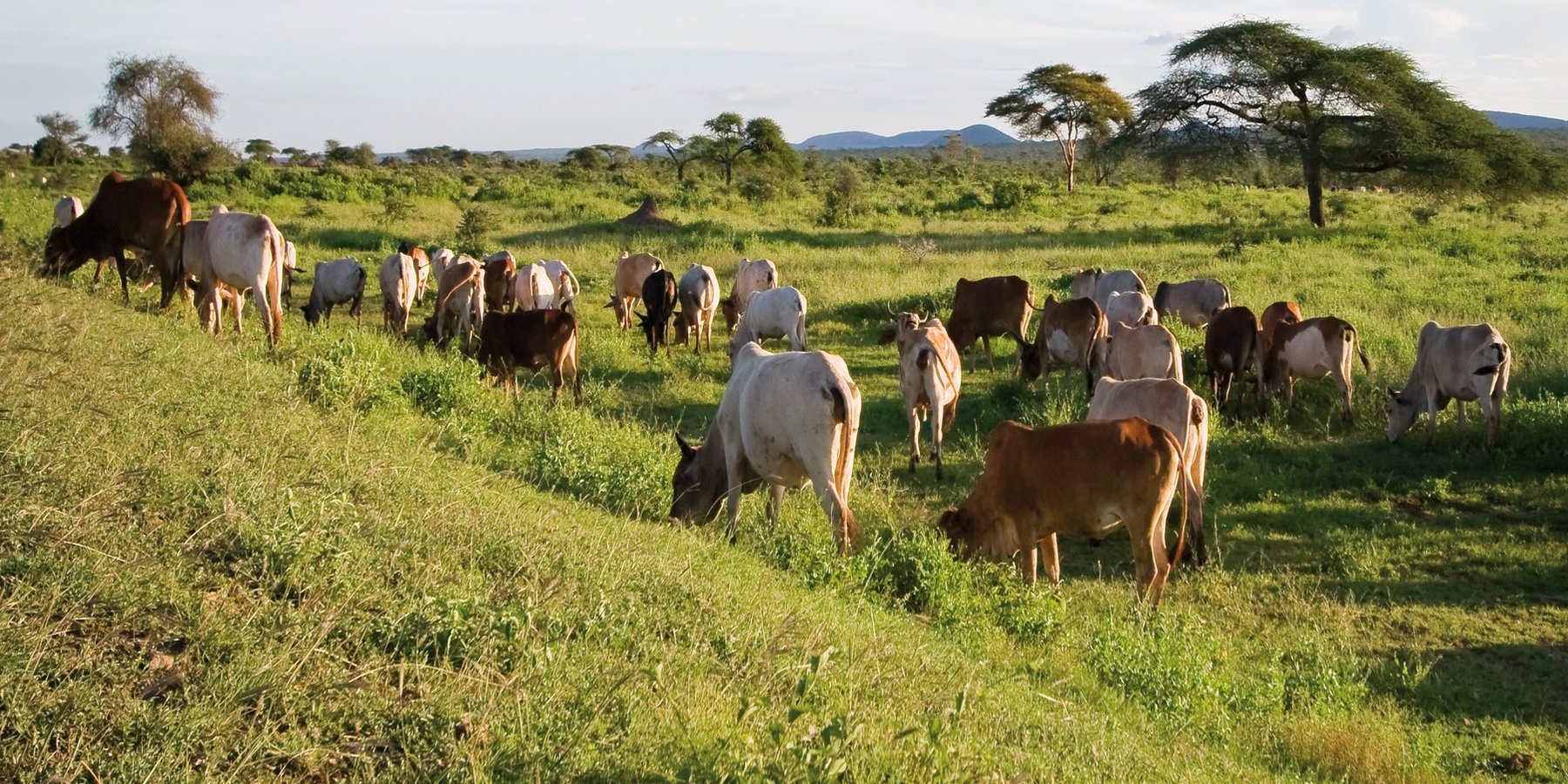
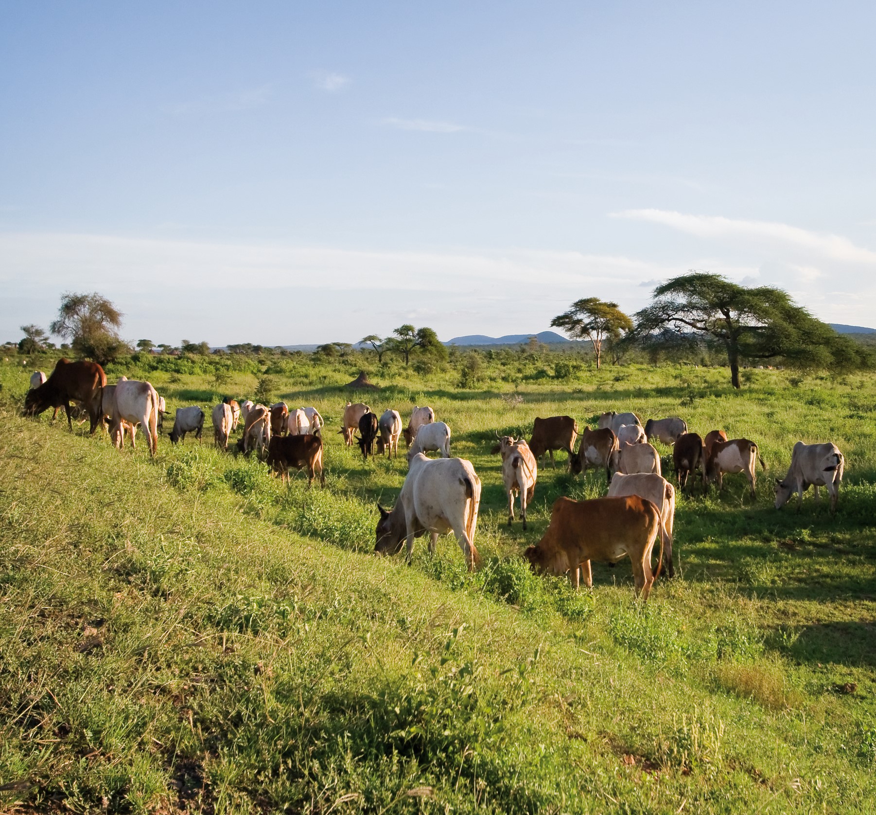
The Dedha grazing system is an ancient, traditional governance system for land and its resources practiced by Boran pastoralists. It carefully balances how pastoralists use rangeland resources. The basis of the technology is three grazing rangeland governance zones: wet season grazing, dry season grazing, and drought reserves. There is also water governance based on a traditional hierarchy of rights. Through this system, Boran pastoralists adapt to severe and recurrent droughts.
2.2 ການອະທິບາຍ ລາຍລະອຽດ ຂອງເຕັກໂນໂລຢີ
ການພັນລະນາ:
This grazing system is applied in Isiolo County, Northern Kenya. The Waso rangelands are inhabited by Boran pastoralists with Somali, Samburu, Rendille and Turkana herders sharing cross-border resources through negotiation. The technology is based on the maintenance of a delicate balance between livestock numbers, the supply of water, and the amount/ quality of standing pasture within the vast grazing area which is water scarce and prone to extreme seasonal variations. Through its main tenet of governing grazing patterns (wet, dry season grazing area and drought reserve) planned use of pasture is decided in large pastoralists’ assemblies attended by elders from a particular “Dedha” (a grazing area, which administratively can be as big as two wards). This process is complicated by dry seasons and droughts of unknown length, with pressure from the community to open grazing reserves. Wrong decisions can spell the end of livelihoods for some families. An ability, which has been gradually eroded over time and by external factors which don’t understand its enormous benefit but there is a project which is using an integrated approach to revive and empower this system.
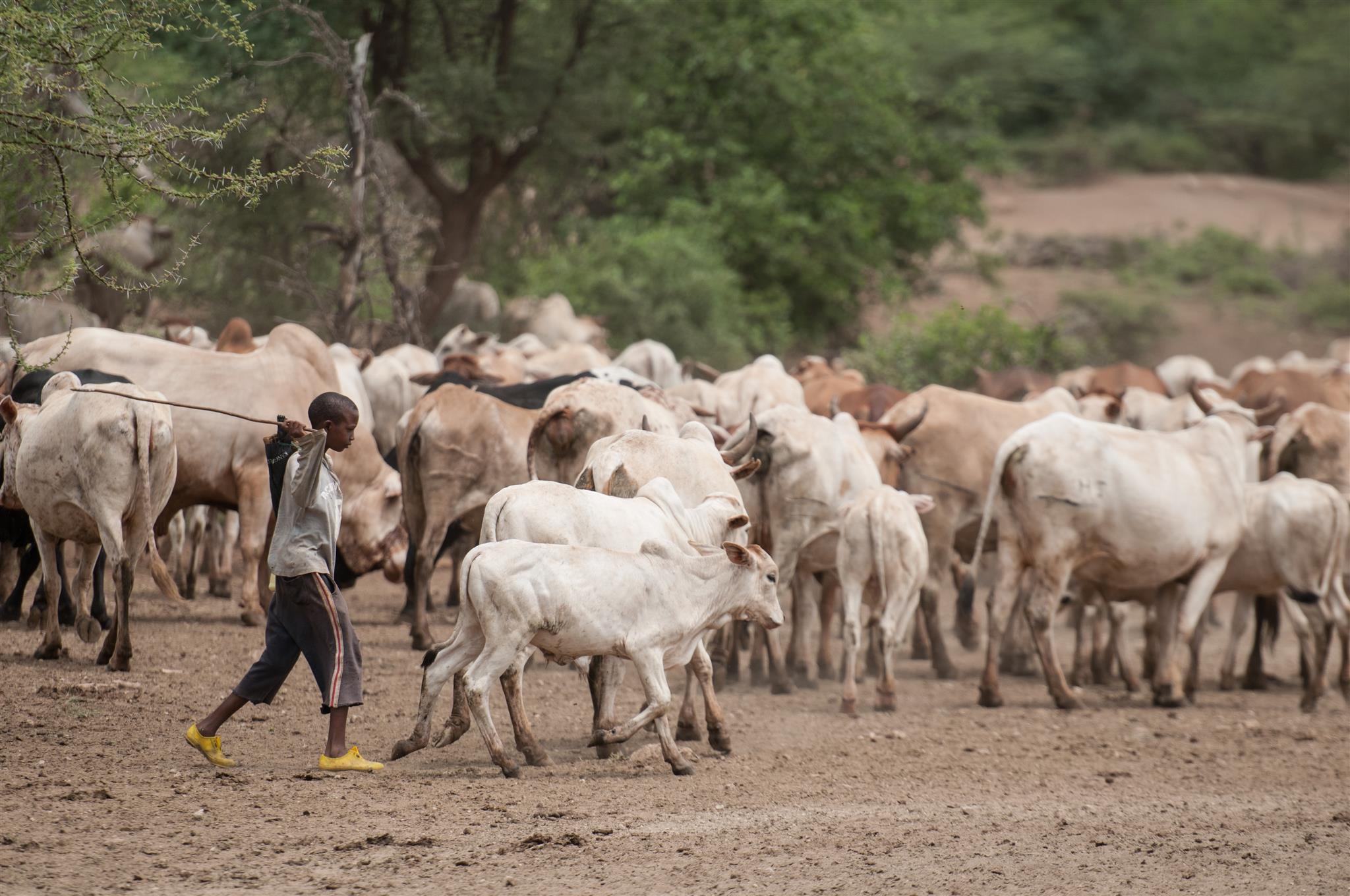
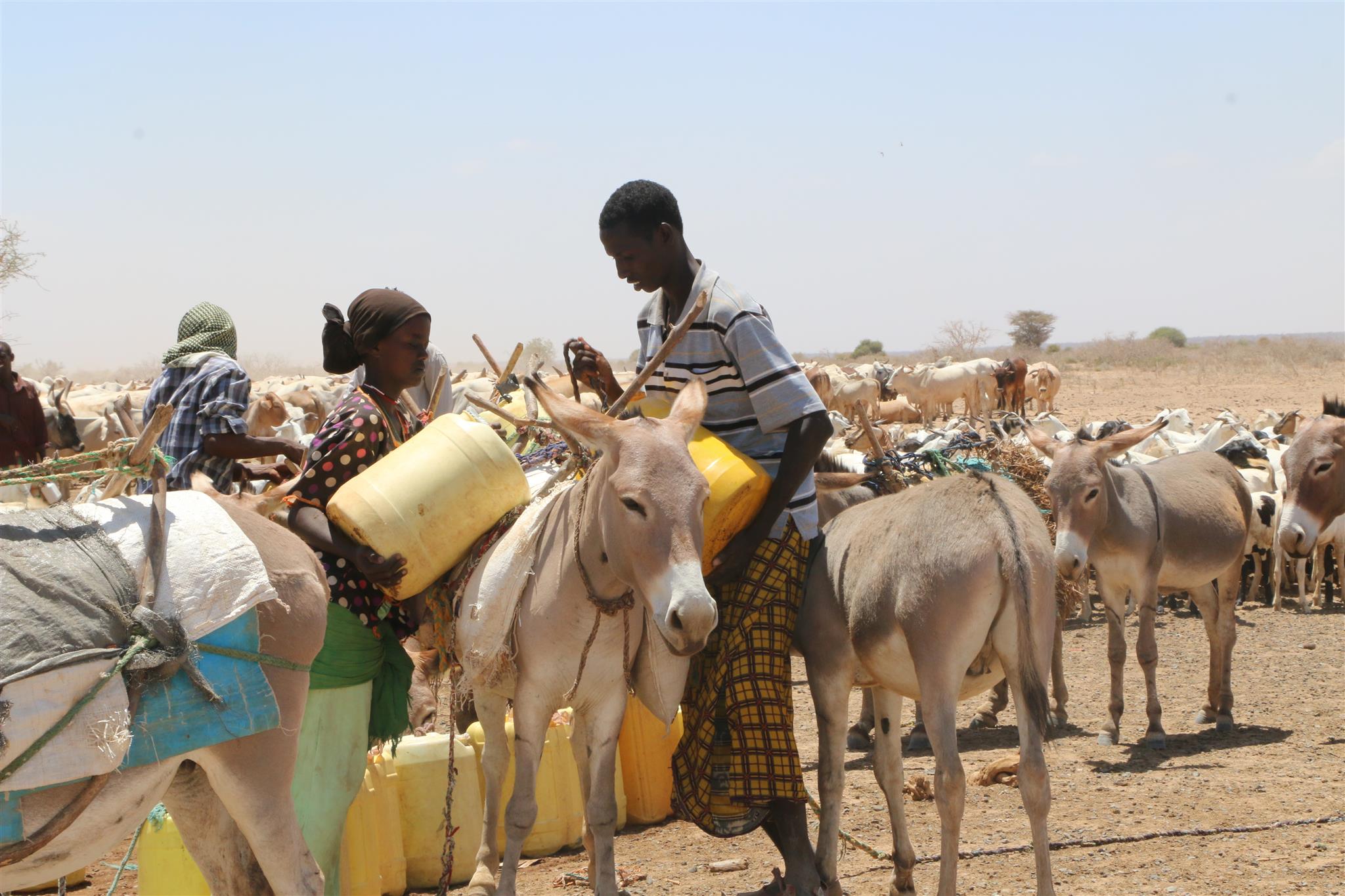
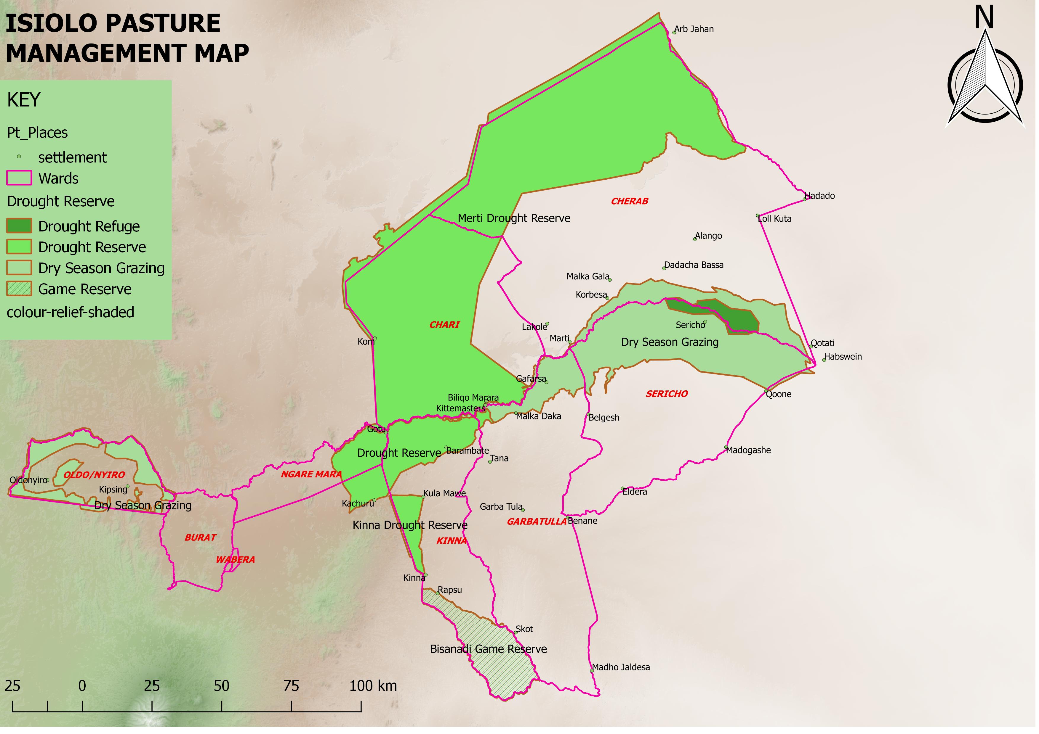
The Jars a Dedha use water points to manage grazing. Different types of water sources need specific forms of management. The most intensive management occurs during droughts at deep wells and boreholes which require the most labour to operate and maintain, and are the most reliable sources of water. Due to the strategic importance of these resources, management falls to the Jarsa Dedha (council of elders). The use of shallow wells is tightly controlled by both the aba ella (the person who first dug it) and aba erega (the owner of the rotter ) working together. Aba ella is assigned first rights to water. If there is spare capacity then ‘second rights’ are decided by aba erega. Second rights would typically fall to those of a different clan, while ‘third rights’ might fall to a different ethnic group. The Borana customs and culture defines both access to certain wells but also the order of priority for watering animals.
In addition, in consultation with the Dedha council of elders, aba erega manages the use of dams and access to rivers. Generally, use of flowing river water is restricted to the dry season and access is limited to designated watering points. These are located some distance downriver from settlements to minimize disruption to inhabitants and to reduce contamination. Temporary water sources during and after the rains are not subject to control except when their use conflicts with restrictions on grazing areas. After watering their livestock, pastoralists traditionally fill their troughs for wildlife at night. This is intended to prevent wildlife from falling into wells - and to seek God’s blessings.
The high variability of rainfall in pastoral areas leads to similarly variable pasture availability. Therefore, management of grazing resources needs to balance maximizing productivity while ensuring survival. Long-term viability of the system depends on the maintenance of adaptive traits within local breeds, and both maintaining and managing resources strategically. Only within these broader goals is the concept of ‘maximizing productivity’ meaningful.
Mature livestock (gues) which are not lactating are moved to remote pastures. The gues, which make up the majority of community livestock, are herded by young unmarried men. By utilizing remote pastures, grazing resources closer to permanent water sources can be preserved for the dry season and droughts. Pasture within the vicinity of homesteads (maar qaae – literally ‘near grass’) is protected from grazing by non-lactating livestock (this is similar to kalo but a kalo reserve need not be next to the homestead ). This pasture is set aside for young animals (calves, lambs, and kids). Migrating livestock have predefined routes that maintain distance from maar qaae. The Dedha council of elders, therefore, controls settlement patterns to preserve key migratory routes. Movement of livestock between different Dedhas must be prearranged with the respective Dedha council of elders who assess spare capacity in terms of water and grazing.
The floodplain grazing area (chaafa) is crucial because it acts as a refuge for livestock during extreme drought. Grazing in chaafa is strictly prohibited during the wet season and one of the critical decisions for the Jarsa Dedha is when to open chaafa after rains have failed. Due to the relatively moist conditions in chaafa, there are additional challenges to animal and human health: namely trypanosomiasis, ticks, pneumonia, and malaria. Jarsa Dedha make decisions primarily concerning seasonal movements from wet to dry season grazing and also the opening of boreholes and chaafa. The overwhelming local consensus is that efficient resource use depends on the ability ofJarsa Dedha to enforce these regulations
2.3 ຮູບພາບຂອງເຕັກໂນໂລຢີ
ສື່ຮູບພາບ
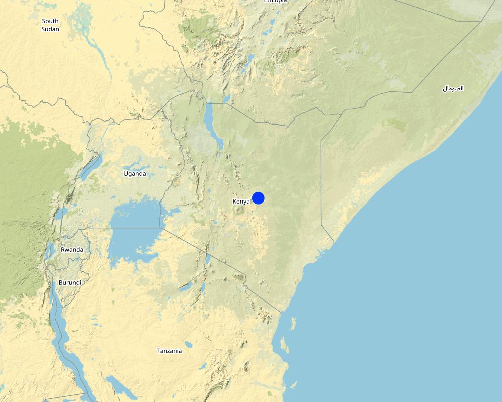
2.5 ປະເທດ / ເຂດ / ສະຖານທີ່ບ່ອນທີ່ ເຕັກໂນໂລຢີ ໄດ້ຮັບການນໍາໃຊ້ ແລະ ທີ່ຖືກປົກຄຸມດ້ວຍການປະເມີນຜົນ
ປະເທດ:
ເຄັນຢາ
ພາກພື້ນ / ລັດ / ແຂວງ:
Isiolo
ຂໍ້ມູນເພີ່ມເຕີມຂອງສະຖານທີ່:
Kinna town, Kinna Ward, isiolo County
ໃຫ້ລະບຸ ການແຜ່ຂະຫຍາຍ ເຕັກໂນໂລຢີ:
- ແຜ່ຂະຫຍາຍຢ່າງໄວວາໃນພື້ນທີ່
ຖ້າຫາກບໍ່ຮູ້ເນື້ອທີ່ທີ່ແນ່ນອນ, ໃຫ້ລະບຸ ເນື້ອທີ່ໂດຍປະມານ ທີ່ໃກ້ຄຽງ:
- > 10,000 ກມ 2
ຄວາມຄິດເຫັນ:
Kinna Town, Kinna Ward, Garbatulla Sub County, Isiolo County
Isiolo County has area of 25,000Km2 but 80% of the area is used for Nomadic pastoralism.
Map
×2.6 ວັນທີໃນການຈັດຕັ້ງປະຕິບັດ
ຖ້າຫາກວ່າ ບໍ່ຮູ້ຈັກ ປີທີ່ຊັດເຈນ ແມ່ນໃຫ້ປະມານ ວັນທີເອົາ:
- ຫຼາຍກ່ອນ 50 ປີຜ່ານມາ (ແບບພື້ນບ້ານ)
2.7 ການນໍາສະເໜີ ເຕັກໂນໂລຢີ
ໃຫ້ລະບຸ ເຕັກໂນໂລຢີ ໄດ້ຖືກຈັດຕັ້ງປະຕິບັດຄືແນວໃດ?
- ເປັນສ່ວນໜື່ງຂອງລະບົບພື້ນເມືອງ (>50 ປີ)
ຄວາມຄິດເຫັນ (ປະເພດ ໂຄງການ ແລະ ອື່ນໆ):
It is inherited from generations before.
3. ການໃຈ້ແຍກ ເຕັກໂນໂລຢີ ໃນການຄຸ້ມຄອງ ດິນແບບຍືນຍົງ
3.1 ຈຸດປະສົງຫຼັກ (ຫຼາຍ) ຂອງເຕັກໂນໂລຢີ
- ຫຼຸດຜ່ອນ, ປ້ອງກັນ, ຟື້ນຟູ ການເຊື່ອມໂຊມຂອງດິນ
- ການອະນຸລັກ ລະບົບນິເວດ
- ປົກປັກຮັກສານໍ້າ / ນໍ້າພື້ນທີ່ - ປະສົມປະສານກັບ ເຕັກໂນໂລຢີອື່ນໆ
- ປົກປັກຮັກສາ / ການປັບປຸງຊີວະນາໆພັນ
- ຫຼຸດຜ່ອນຄວາມສ່ຽງ ທາງໄພພິບັດທໍາມະຊາດ
- ປັບຕົວຕໍ່ກັບການປ່ຽນແປງດິນຟ້າອາກາດ / ທີ່ຮ້າຍແຮງ ແລະ ຜົນກະທົບ
- ຫຼຸດຜ່ອນຜົນກະທົບ ຈາກການປ່ຽນແປງດິນຟ້າອາກາດ
- ສ້າງຜົນກະທົບ ທາງເສດຖະກິດ ທີ່ເປັນປະໂຫຍດ
- ສ້າງຜົນກະທົບ ທີ່ເປັນທາງບວກ ໃຫ້ແກ່ສັງຄົມ
3.2 ປະເພດການນໍາໃຊ້ທີ່ດິນ ໃນປະຈຸບັນ() ທີ່ເຕັກໂນໂລຢີ ໄດ້ຖືກນໍາໃຊ້

ທົ່ງຫຍ້າລ້ຽງສັດ
ການລ້ຽງສັດແບບປ່ອຍ ຕາມທຳມະຊາດ:
- ແບບປ່ອຍ ຕາມທຳມະຊາດ
- ການລ້ຽງສັດແບບເຄີ່ງປ່ອຍ
ທົ່ງຫຍ້າລ້ຽງສັດແບບສຸມ / ການຜະລິດອາຫານສັດ:
- ປັບປຸງ ທົ່ງຫຍ້າ
ປະເພດສັດ:
- ແບ້
- ອູດ
- ແກະ
- cattle
ສາຍພັນ:
ອູດ
ນັບ:
39100
ສາຍພັນ:
ແບ້
ນັບ:
399000
ສາຍພັນ:
ແກະ
ນັບ:
361900
ຄວາມຄິດເຫັນ:
Number of growing seasons per year: 2
Grasses and shrubs which nourishes livestock grows during the rainy seasons
Livestock density: Isiolo county is endowed with a substantial livestock resource base that includes 198,500 cattle, 399,000 goats, 361,900 sheep and 39,100 camels
3.4 ການສະໜອງນ້ຳ
ການສະໜອງນໍ້າ ໃນພື້ນທີ່ ທີ່ໄດ້ນໍາໃຊ້ ເຕັກໂນໂລຢີ:
- ນໍ້າຝົນ
ຄວາມຄິດເຫັນ:
The pastoralists depend on attendant pasture after the rains which are bi-modal in Isiolo County (Long and Short rains).
3.5 ການນໍາໃຊ້ເຕັກໂນໂລຢີ ທີ່ຢູ່ໃນກຸ່ມການຄຸ້ມຄອງ ທີ່ດິນແບບຍືນຍົງ
- ການຄຸ້ມຄອງສັດລ້ຽງ ແລະ ທົ່ງຫຍ້າລ້ຽງສັດ
3.6 ມາດຕະການ ການຄຸ້ມຄອງ ທີ່ດິນແບບຍືນຍົງ ປະກອບດ້ວຍ ເຕັກໂນໂລຢີ

ມາດຕະການ ທາງດ້ານການຄຸ້ມຄອງ
- M2: ການປ່ຽນແປງ ການຈັດການຄຸ້ມຄອງ / ລະດັບຄວາມໜາແໜ້ນ
- M3: ອີງຕາມສະພາບແວດລ້ອມ ທາງທຳມະຊາດ ແລະ ມະນຸດ
- M4: ການປ່ຽນແປງ ໄລຍະເວລາ ໃນການຈັດຕັ້ງປະຕິບັດ ກິດຈະກໍາ
3.7 ປະເພດດິນເຊື່ອມໂຊມ ຫຼັກທີ່ໄດ້ນໍາໃຊ້ ເຕັກໂນໂລຢີ

ການເຊື່ອມໂຊມ ທາງຊີວະພາບ
- Bc: ການຫຼຸດຜ່ອນການປົກຫຸ້ມຂອງພືດ
- Bh: ການສູນເສຍ ທີ່ຢູ່ອາໃສ ຂອງສິ່ງທີ່ມີຊິວິດ
- Bf: ຜົນກະທົບ ຄວາມເສຍຫາຍ ຈາກໄຟໄໝ້
- Bs: ຄຸນນະພາບ / ການອັດແໜ້ນ ຂອງສາຍພັນຫຼຸດລົງ

ການເຊື່ອມໂຊມ ຂອງນໍ້າ
- Ha: ສະພາບແຫ້ງແລ້ງ
- Hs: ການປ່ຽນແປງ ປະລິມານ ນໍ້າໜ້າດິນ
- Hp: ຄຸນນະພາບ ຂອງນ້ຳຊັ້ນໜ້າດິນຫຼຸດລົງ
- HW: ການຫຼຸດຜ່ອນ ຄວາມສາມາດ ໃນການປ້ອງກັນພື້ນທີ່ດິນທາມ
3.8 ການປ້ອງກັນ, ການຫຼຸດຜ່ອນ, ຫຼືການຟື້ນຟູຂອງການເຊື່ອມໂຊມຂອງດິນ
ໃຫ້ລະບຸ ເປົ້າໝາຍ ເຕັກໂນໂລຢີ ທີ່ພົວພັນ ກັບຄວາມເຊື່ອມໂຊມຂອງດິນ:
- ປ້ອງກັນການເຊື່ອມໂຊມຂອງດິນ
- ປັບຕົວຕໍ່ການເຊື່ອມໂຊມຂອງດິນ
4. ຂໍ້ກໍາໜົດ, ກິດຈະກໍາການປະຕິບັດ, ວັດຖຸດິບ, ແລະຄ່າໃຊ້ຈ່າຍ
4.1 ເຕັກນິກ ໃນການແຕ້ມແຜນວາດ ເຕັກໂນໂລຢີ
ຄຸນລັກສະນະ ຂອງເຕັກນິກ (ທີ່ກ່ຽວຂ້ອງ ກັບການແຕ້ມແຜນວາດ ທາງດ້ານເຕັກນີກ):
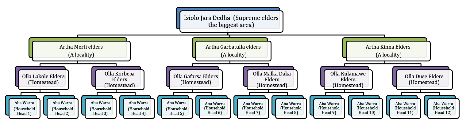
The technology is implemented in a vast area of rangelands in Isiolo County which covers around 20,000 km2 inhabited by Boran pastoralists under common management of Isiolo Jars Dedha (Council of elders). The rangelands are subdivided into around 14 arthas (localities) which are separately managed by artha elders and within which there are also ollas (homesteads) which the elders oversee. The elders manage key resources that are essential for pastoral livelihood. The resources are; prime pasture/grazing areas, water points e.g. streams, rivers, springs, shallow wells and pans, wildlife, forests, minerals, sand and other valuable stones e.g. gemstones (bojimine) and quarry, Trees and their products e.g. makuti, medicinal herbs, wild, fruits, resins, gum arabic.
ຜູ້ຂຽນ:
Ibrahim Jarso
ວັນທີ:
02/05/2017
ຜູ້ຂຽນ:
Ibrahim Jarso
ວັນທີ:
06/03/2017
4.2 ຂໍ້ມູນທົ່ວໄປກ່ຽວກັບການຄິດໄລ່ປັດໃຈຂາເຂົ້າໃນການຜະລິດ ແລະ ມູນຄ່າອື່ນໆ
ລະບຸ ວິທີການ ຄຳໃຊ້ຈ່າຍ ແລະ ປັດໄຈນໍາເຂົ້າ ທີ່ໄດ້ຄິດໄລ່:
- ຕໍ່ພື້ນທີ່ ທີ່ໄດ້ຈັດຕັ້ງປະຕິບັດ ເຕັກໂນໂລຢີ
ໃຫ້ລະບຸຫົວໜ່ວຍ ຂະໜາດ ແລະ ເນື້ອທີ່:
20,000km2
ລະບຸ ຄ່າຈ້າງ ຄ່າແຮງງານສະເລ່ຍ ຕໍ່ ວັນ:
2,500 Kenya Shillings
4.3 ການສ້າງຕັ້ງກິດຈະກໍາ
| ກິດຈະກໍາ | Timing (season) | |
|---|---|---|
| 1. | Dedha elders meetings | All seasons |
| 2. | Surveillance of grazing areas | Largely after the rains |
| 3. | Settling resource based disputes | Largely during dry seasons and drought |
| 4. | Deciding on when to access reserved pasture lands | Dry seasons and drought reserves |
| 5. | Negotiations on access to pasture within and across borders | Drought and Long dry seasons |
ຄວາມຄິດເຫັນ:
Regarding Surveillance of grazing areas, they observe pasture conditions and unwarranted access to preserved grazing areas and report on conditions. The surveillance is elevated after the rains as communities are in wet season grazing area depending on sub-surface water from the rains.
4.5 ບໍາລຸງຮັກສາ / ແຜນຈັດຕັ້ງປະຕິບັດ ກິດຈະກໍາ
| ກິດຈະກໍາ | ໄລຍະເວລາ / ຄວາມຖີ່ | |
|---|---|---|
| 1. | Meetings | All seasons |
| 2. | Surveillance of grazing lands | After the two rainy seasons |
4.7 ປັດໄຈ ທີ່ສໍາຄັນ ທີ່ສົ່ງຜົນກະທົບ ຕໍ່ຄ່າໃຊ້ຈ່າຍ
ໃຫ້ອະທິບາຍ ປັດໃຈ ທີ່ສົ່ງຜົນກະທົບ ຕໍ່ຕົ້ນທຶນ ໃນການຈັດຕັ້ງປະຕິບັດ:
This is a traditional technology of governing rangelands which was started and done voluntarily by the pastoralists. The costs considered are for subsistence of elders undertaking the meetings and discussions on range governance but the process still goes on even without the financial support as the actors involved do it for their own benefits.
5. ສະພາບແວດລ້ອມທໍາມະຊາດ ແລະ ມະນຸດ
5.1 ອາກາດ
ປະລິມານນໍ້າຝົນປະຈໍາປີ
- < 250 ມີລິແມັດ
- 251-500 ມີລິແມັດ
- 501-750 ມີລິແມັດ
- 751-1,000 ມີລິແມັດ
- 1,001-1,500 ມີລິແມັດ
- 1,501-2,000 ມີລິແມັດ
- 2,001-3,000 ມີລິແມັດ
- 3,001-4,000 ມີລິແມັດ
- > 4,000 ມີລິແມັດ
ຂໍ້ມູນສະເພາະ / ຄວາມເຫັນກ່ຽວກັບ ປະລິມານນໍ້າຝົນ:
The rains are bimodal (Long rains of March-April-May and Short rains of October-November-December). The rains are unpredictable, erratic and not evenly distributed but pastoralists move to take advantage of difference in pasture quality and quantity.
ໃຫ້ລະບຸ ຊື່ສະຖານີ ອຸຕຸນິຍົມ ເພື່ອເປັນຂໍ້ມູນອ້າງອີງ:
Garbatulla automatic weather station
ເຂດສະພາບອາກາດກະສິກໍາ
- ເຄິ່ງແຫ້ງແລ້ງ
- ແຫ້ງແລ້ງ
5% of the area is Semi-arid and 95% is Arid.
5.2 ພູມິປະເທດ
ຄ່າສະເລ່ຍ ຄວາມຄ້ອຍຊັນ:
- ພື້ນທີ່ຮາບພຽງ (0-2%)
- ອ່ອນ (3-5 %)
- ປານກາງ (6-10 %)
- ມ້ວນ (11-15 %)
- ເນີນ(16-30%)
- ໍຊັນ (31-60%)
- ຊັນຫຼາຍ (>60%)
ຮູບແບບຂອງດິນ:
- ພູພຽງ / ທົ່ງພຽງ
- ສັນພູ
- ເປີ້ນພູ
- ເນີນພູ
- ຕີນພູ
- ຮ່ອມພູ
ເຂດລະດັບສູງ:
- 0-100 ແມັດ a.s.l.
- 101-500 ແມັດ a.s.l.
- 501-1,000 ແມັດ a.s.l.
- 1,001-1,500 ແມັດ a.s.l.
- 1,501-2,000 ແມັດ a.s.l.
- 2,001-2,500 ແມັດ a.s.l.
- 2,501-3,000 ແມັດ a.s.l.
- 3,001-4,000 ແມັດ a.s.l.
- > 4,000 ແມັດ a.s.l.
ໃຫ້ລະບຸ ເຕັກໂນໂລຢີ ທີ່ໄດ້ຖືກນຳໃຊ້:
- ບໍ່ກ່ຽວຂ້ອງ
5.3 ດິນ
ຄວາມເລິກ ຂອງດິນສະເລ່ຍ:
- ຕື້ນຫຼາຍ (0-20 ຊັງຕີແມັດ)
- ຕື້ນ (21-50 ຊຕມ)
- ເລີກປານກາງ (51-80 ຊຕມ)
- ເລິກ (81-120 ຊມ)
- ເລິກຫຼາຍ (> 120 cm)
ເນື້ອດິນ (ໜ້າດິນ):
- ຫຍາບ / ເບົາ (ດິນຊາຍ)
- ປານກາງ (ດິນໜຽວ, ດິນໂຄນ)
ເນື້ອດິນ (ເລິກຈາກໜ້າດິນ ລົງໄປຫຼາຍກວ່າ 20 ຊັງຕິແມັດ):
- ຫຍາບ / ເບົາ (ດິນຊາຍ)
- ປານກາງ (ດິນໜຽວ, ດິນໂຄນ)
ຊັ້ນອິນຊີວັດຖຸ ເທິງໜ້າດິນ:
- ປານກາງ (1-3 %)
5.4 ມີນໍ້າ ແລະ ຄຸນນະພາບ
ລະດັບ ນໍ້າໃຕ້ດິນ:
> 50 ແມັດ
ການມີນໍ້າ ເທິງໜ້າດິນ:
ປານກາງ
ຄຸນນະພາບນໍ້າ (ບໍ່ມີການບໍາບັດ):
ມີນໍ້າດື່ມ
ມີບັນຫາ ກ່ຽວກັບນໍ້າເຄັມບໍ່?
ແມ່ນ
ລະບຸ ຊະນິດ:
Many boreholes dug in the area is saline
ເກີດມີນໍ້າຖ້ວມ ໃນພື້ນທີ່ບໍ່?
ແມ່ນ
ເປັນປົກກະຕິ:
ຕອນ
ຄວາມຄິດເຫັນ ແລະ ຂໍ້ກໍານົດ ເພີ່ມເຕີມ ກ່ຽວກັບ ຄຸນນະພາບ ແລະ ປະລິມານ ຂອງນ້ຳ:
The Ewaso Nyiro River floods every rainy seasons
5.5 ຊີວະນາໆພັນ
ຄວາມຫຼາກຫຼາຍ ທາງສາຍພັນ:
- ປານກາງ
ຄວາມຫຼາກຫຼາຍ ທາງດ້ານ ທີ່ຢູ່ອາໃສ ຂອງສິ່ງທີ່ມີຊີວິດ:
- ປານກາງ
5.6 ຄຸນລັກສະນະ ຂອງຜູ້ນໍາໃຊ້ທີ່ດິນ ທີ່ໄດ້ນໍາໃຊ້ເຕັກໂນໂລຢີ
ຢູ່ປະຈຳ ຫຼື ເຄື່ອນຍ້າຍຕະຫຼອດ:
- ແບບເຄີ່ງຂັງ-ເຄີ່ງປ່ອຍ
- ແບບປ່ອຍຕາມທຳມະຊາດ
ລະບົບ ການຕະຫຼາດ ແລະ ຜົນຜະລິດ:
- ກຸ້ມຕົນເອງ (ພໍພຽງ)
ລາຍຮັບ ທີ່ບໍ່ໄດ້ມາຈາກ ການຜະລິດ ກະສິກໍາ:
- ໜ້ອຍກ່ວາ 10 % ຂອງລາຍຮັບທັງໝົດ
ລະດັບຄວາມຮັ່ງມີ:
- ທຸກຍາກຫຼາຍ
- ທຸກຍາກ
ບຸກຄົນ ຫຼື ກຸ່ມ:
- ບຸກຄົນ / ຄົວເຮືອນ
- ກຸ່ມ / ຊຸມຊົນ
ລະດັບ ການຫັນເປັນກົນຈັກ:
- ການໃຊ້ແຮງງານຄົນ
- ສັດລາກແກ່
ເພດ:
- ຜູ້ຊາຍ
ອາຍຸ ຂອງຜູ້ນໍາໃຊ້ທີ່ດິນ:
- ຊາວໜຸ່ມ
- ໄວກາງຄົນ
5.7 ເນື້ອທີ່ສະເລ່ຍຂອງດິນ ທີ່ຜູ້ນຳໃຊ້ທີ່ດິນ ໃຊ້ເຮັດເຕັກໂນໂລຢີ
- <0.5 ເຮັກຕາ
- 0.5-1 ເຮັກຕາ
- 1-2 ເຮັກຕາ
- 2-5 ເຮັກຕາ
- 5-15 ເຮັກຕາ
- 15-50 ເຮັກຕາ
- 50-100 ເຮັກຕາ
- 100-500 ເຮັກຕາ
- 500-1,000 ເຮັກຕາ
- 1,000-10,000 ເຮັກຕາ
- > 10,000 ເຮັກຕາ
ຖືໄດ້ວ່າ ເປັນຂະໜາດນ້ອຍ, ກາງ ຫຼື ໃຫຍ່ (ອີງຕາມເງື່ອນໄຂ ສະພາບຄວາມເປັນຈິງ ຂອງທ້ອງຖີ່ນ)? :
- ຂະໜາດໃຫຍ່
5.8 ເຈົ້າຂອງທີ່ດິນ, ສິດໃຊ້ທີ່ດິນ, ແລະ ສິດທິການນໍາໃຊ້ນໍ້າ
ເຈົ້າຂອງດິນ:
- ຊຸມຊົນ / ບ້ານ
ສິດທິ ໃນການນໍາໃຊ້ທີ່ດິນ:
- ຊຸມຊົນ (ທີ່ມີການຈັດຕັ້ງ)
ສິດທິ ໃນການນໍາໃຊ້ນໍ້າ:
- ຊຸມຊົນ (ທີ່ມີການຈັດຕັ້ງ)
5.9 ການເຂົ້າເຖິງການບໍລິການ ແລະ ພື້ນຖານໂຄງລ່າງ
ສຸຂະພາບ:
- ທຸກຍາກ
- ປານກາງ
- ດີ
ການສຶກສາ:
- ທຸກຍາກ
- ປານກາງ
- ດີ
ການຊ່ວຍເຫຼືອ ດ້ານວິຊາການ:
- ທຸກຍາກ
- ປານກາງ
- ດີ
ການຈ້າງງານ (ຕົວຢ່າງ, ການເຮັດກິດຈະກໍາອື່ນ ທີ່ບໍ່ແມ່ນ ການຜະລິດກະສິກໍາ):
- ທຸກຍາກ
- ປານກາງ
- ດີ
ຕະຫຼາດ:
- ທຸກຍາກ
- ປານກາງ
- ດີ
ພະລັງງານ:
- ທຸກຍາກ
- ປານກາງ
- ດີ
ຖະໜົນຫົນທາງ ແລະ ການຂົນສົ່ງ:
- ທຸກຍາກ
- ປານກາງ
- ດີ
ການດື່ມນໍ້າ ແລະ ສຸຂາພິບານ:
- ທຸກຍາກ
- ປານກາງ
- ດີ
ການບໍລິການ ທາງດ້ານການເງິນ:
- ທຸກຍາກ
- ປານກາງ
- ດີ
6. ຜົນກະທົບ ແລະ ລາຍງານສະຫຼຸບ
6.1 ການສະແດງຜົນກະທົບ ພາຍໃນພື້ນທີ່ ທີ່ໄດ້ຈັດຕັ້ງປະຕິບັດ ເຕັກໂນໂລຢີ
ຜົນກະທົບທາງເສດຖະກິດສັງຄົມ
ການຜະລິດ
ຜົນຜະລິດຂອງສັດ
ປະລິມານ ກ່ອນການຈັດຕັ້ງປະຕິບັດ ການຄຸ້ມຄອງ ທີ່ດິນແບບຍືນຍົງ:
0
ປະລີມານ ຫຼັງການຈັດຕັ້ງປະຕິບັດ ການຄຸ້ມຄອງ ທີ່ດິນແບບຍືນຍົງ:
2
ຄວາມຄິດເຫັນ / ລະບຸແຈ້ງ:
The frequent and Severe drought has reduced the number of livestock and created a big group of pastoral dropouts but with improved rangeland management through the revived traditional systems animal production is gradually improving.
ການຈັດການຄຸ້ມຄອງທີ່ດິນ
ປະລິມານ ກ່ອນການຈັດຕັ້ງປະຕິບັດ ການຄຸ້ມຄອງ ທີ່ດິນແບບຍືນຍົງ:
0
ປະລີມານ ຫຼັງການຈັດຕັ້ງປະຕິບັດ ການຄຸ້ມຄອງ ທີ່ດິນແບບຍືນຍົງ:
2
ມີນໍ້າ ແລະ ຄຸນນະພາບ
ມີນໍ້າດື່ມ
ປະລິມານ ກ່ອນການຈັດຕັ້ງປະຕິບັດ ການຄຸ້ມຄອງ ທີ່ດິນແບບຍືນຍົງ:
0
ປະລີມານ ຫຼັງການຈັດຕັ້ງປະຕິບັດ ການຄຸ້ມຄອງ ທີ່ດິນແບບຍືນຍົງ:
1
ມີນໍ້າ ໃຫ້ສັດລ້ຽງ
ປະລິມານ ກ່ອນການຈັດຕັ້ງປະຕິບັດ ການຄຸ້ມຄອງ ທີ່ດິນແບບຍືນຍົງ:
0
ປະລີມານ ຫຼັງການຈັດຕັ້ງປະຕິບັດ ການຄຸ້ມຄອງ ທີ່ດິນແບບຍືນຍົງ:
2
ຜົນກະທົບຕໍ່ລະບົບນິເວດ
ວົງຈອນນໍ້າ / ນໍ້າ
ປະລິມານນໍ້າ
ປະລິມານ ກ່ອນການຈັດຕັ້ງປະຕິບັດ ການຄຸ້ມຄອງ ທີ່ດິນແບບຍືນຍົງ:
0
ປະລີມານ ຫຼັງການຈັດຕັ້ງປະຕິບັດ ການຄຸ້ມຄອງ ທີ່ດິນແບບຍືນຍົງ:
2
ການຂຸດຄົ້ນ / ການເກັບກັກນໍ້າ
ປະລິມານ ກ່ອນການຈັດຕັ້ງປະຕິບັດ ການຄຸ້ມຄອງ ທີ່ດິນແບບຍືນຍົງ:
0
ປະລີມານ ຫຼັງການຈັດຕັ້ງປະຕິບັດ ການຄຸ້ມຄອງ ທີ່ດິນແບບຍືນຍົງ:
2
ຊີວະນານາພັນ: ສັດ, ພືດ
ການປົກຫຸ້ມຂອງພືດ
ປະລິມານ ກ່ອນການຈັດຕັ້ງປະຕິບັດ ການຄຸ້ມຄອງ ທີ່ດິນແບບຍືນຍົງ:
0
ປະລີມານ ຫຼັງການຈັດຕັ້ງປະຕິບັດ ການຄຸ້ມຄອງ ທີ່ດິນແບບຍືນຍົງ:
2
ສາຍພັນຕ່າງຖີ່ນ
ປະລິມານ ກ່ອນການຈັດຕັ້ງປະຕິບັດ ການຄຸ້ມຄອງ ທີ່ດິນແບບຍືນຍົງ:
0
ປະລີມານ ຫຼັງການຈັດຕັ້ງປະຕິບັດ ການຄຸ້ມຄອງ ທີ່ດິນແບບຍືນຍົງ:
1
ຄວາມຫຼາກຫຼາຍ ທາງດ້ານທີ່ຢູ່ອາໃສ ຂອງສິ່ງທີ່ມີຊີວິດ
ປະລິມານ ກ່ອນການຈັດຕັ້ງປະຕິບັດ ການຄຸ້ມຄອງ ທີ່ດິນແບບຍືນຍົງ:
0
ປະລີມານ ຫຼັງການຈັດຕັ້ງປະຕິບັດ ການຄຸ້ມຄອງ ທີ່ດິນແບບຍືນຍົງ:
2
ການຫຼຸດຜ່ອນ ຄວາມສ່ຽງ ຈາກໄພພິບັດ ແລະ ອາກາດປ່ຽນແປງ
ຜົນກະທົບ ຂອງໄພແຫ້ງແລ້ງ
ປະລິມານ ກ່ອນການຈັດຕັ້ງປະຕິບັດ ການຄຸ້ມຄອງ ທີ່ດິນແບບຍືນຍົງ:
-2
ປະລີມານ ຫຼັງການຈັດຕັ້ງປະຕິບັດ ການຄຸ້ມຄອງ ທີ່ດິນແບບຍືນຍົງ:
2
ການປ່ຽນແປງ ອາກາດ ໃນວົງແຄບ
ປະລິມານ ກ່ອນການຈັດຕັ້ງປະຕິບັດ ການຄຸ້ມຄອງ ທີ່ດິນແບບຍືນຍົງ:
0
ປະລີມານ ຫຼັງການຈັດຕັ້ງປະຕິບັດ ການຄຸ້ມຄອງ ທີ່ດິນແບບຍືນຍົງ:
2
6.2 ຜົນກະທົບທາງອ້ອມ ຈາກການນໍາໃຊ້ເຕັກໂນໂລຢີ
ສາມາດເຂົ້າເຖິງແຫຼ່ງນໍ້າ
ປະລິມານ ກ່ອນການຈັດຕັ້ງປະຕິບັດ ການຄຸ້ມຄອງ ທີ່ດິນແບບຍືນຍົງ:
0
ປະລີມານ ຫຼັງການຈັດຕັ້ງປະຕິບັດ ການຄຸ້ມຄອງ ທີ່ດິນແບບຍືນຍົງ:
2
ຄວາມຄິດເຫັນ / ລະບຸແຈ້ງ:
The preserved grazing lands regenerate and is less degraded. The improved environment in the preserved areas lead to less erosion and proper recharge of underground water. This was observed in Kinna Village where the Odha Springs improved its flow and also the recharge to Moliti shallow wells were improved with proper grazing management in Kinna.
ການໄຫຼຂອງນໍ້າໃນລະດູແລ້ງ
ປະລິມານ ກ່ອນການຈັດຕັ້ງປະຕິບັດ ການຄຸ້ມຄອງ ທີ່ດິນແບບຍືນຍົງ:
0
ປະລີມານ ຫຼັງການຈັດຕັ້ງປະຕິບັດ ການຄຸ້ມຄອງ ທີ່ດິນແບບຍືນຍົງ:
2
6.3 ການປ້ອງກັນ ແລະ ຄວາມບອບບາງ ຂອງເຕັກໂນໂລຢິ ໃນການປ່ຽນແປງສະພາບດິນຟ້າອາກາດ ແລະ ກ່ຽວຂ້ອງກັບອາກາດທີ່ມີການປ່ຽນແປງທີ່ຮຸນແຮງ / ໄພພິບັດທາງທໍາມະຊາດ (ຮັບຮູ້ໄດ້ໂດຍຜູ້ນໍາໃຊ້ທີ່ດິນ)
ການປ່ຽນແປງດິນຟ້າອາກາດ ເທື່ອລະກ້າວ
ການປ່ຽນແປງດິນຟ້າອາກາດ ເທື່ອລະກ້າວ
| ລະດູການ | ເພີ່ມຂື້ນ ຫຼື ຫຼຸດລົງ | ການນໍາໃຊ້ ເຕັກໂນໂລຢີ ສາມາດ ຮັບມື ໄດ້ຄືແນວໃດ? | |
|---|---|---|---|
| ອຸນຫະພູມລະດູການ | ລະດູແລ້ງ | ເພີ່ມຂື້ນ | ດີຫຼາຍ |
| ປະລິມານນໍ້າຝົນຕາມລະດູການ | ລະດູແລ້ງ | ຫຼຸດລົງ | ດີຫຼາຍ |
ອາກາດ ທີ່ກ່ຽວພັນກັບຄວາມຮຸນແຮງ (ໄພພິບັດທາງທໍາມະຊາດ)
ໄພພິບັດທາງພູມອາກາດ
| ການນໍາໃຊ້ ເຕັກໂນໂລຢີ ສາມາດ ຮັບມື ໄດ້ຄືແນວໃດ? | |
|---|---|
| ແຫ້ງແລ້ງ | ດີຫຼາຍ |
| ໄຟໄໝ້ດິນ | ດີ |
ໄພພິບັດທາງອຸທົກກະສາກ
| ການນໍາໃຊ້ ເຕັກໂນໂລຢີ ສາມາດ ຮັບມື ໄດ້ຄືແນວໃດ? | |
|---|---|
| ໂດຍທົ່ວໄປ (ແມ່ນໍ້າ) ນໍ້າຖ້ວມ | ດີ |
| ນໍ້າຖ້ວມຮູນແຮງ | ປານກາງ |
ໄພພິບັດທາງຊີວະພາບ
| ການນໍາໃຊ້ ເຕັກໂນໂລຢີ ສາມາດ ຮັບມື ໄດ້ຄືແນວໃດ? | |
|---|---|
| ພະຍາດລະບາດ | ປານກາງ |
ຜົນສະທ້ອນສະພາບອາກາດອື່ນໆທີ່ກ່ຽວຂ້ອງ
ຜົນສະທ້ອນສະພາບອາກາດອື່ນໆທີ່ກ່ຽວຂ້ອງ
| ການນໍາໃຊ້ ເຕັກໂນໂລຢີ ສາມາດ ຮັບມື ໄດ້ຄືແນວໃດ? | |
|---|---|
| ໄລຍະເວລາການຂະຫຍາຍຕົວຫຼຸດລົງ | ດີຫຼາຍ |
6.4 ການວິເຄາະຕົ້ນທຶນ ແລະ ຜົນປະໂຫຍດ
ຈະເຮັດປະໂຫຍດເພື່ອປຽບທຽບກັບຄ່າໃຊ້ຈ່າຍກັບສິ່ງກໍ່ສ້າງ (ຈາກທັດສະນະຂອງຜູ້ນຳໃຊ້ທີ່ດິນ) ໄດ້ແນວໃດ?
ຜົນຕອບແທນ ໃນໄລຍະສັ້ນ:
ຜົນກະທົບທາງບວກເລັກນ້ອຍ
ຜົນຕອບແທນ ໃນໄລຍະຍາວ:
ຜົນກະທົບທາງບວກ
ຈະໄດ້ຮັບຜົນປະໂຫຍດເມື່ອປຽບທຽບກັບ / ຄ່າໃຊ້ຈ່າຍໃນການບຳລຸງຮັກສາທີເ່ກີດຂື້ນອິກ (ຈາກທັດສະນະຄະຕິຂອງຜູ້ນຳໃຊ້ທີ່ດິນ) ໄດ້ແນວໃດ?
ຜົນຕອບແທນ ໃນໄລຍະສັ້ນ:
ຜົນກະທົບທາງບວກເລັກນ້ອຍ
ຜົນຕອບແທນ ໃນໄລຍະຍາວ:
ຜົນກະທົບທາງບວກເລັກນ້ອຍ
6.5 ການປັບຕົວຮັບເອົາເຕັກໂນໂລຢີ
- > 50%
ຖ້າຫາກວ່າມີ, ປະລິມານ (ຈໍານວນຂອງຄົວເຮືອນ / ເນື້ອທີ່ການຄຸ້ມຄອງ):
80% of Isiolo County (Around 24,500 Households)
ທັງໝົດນັ້ນ ແມ່ນໃຜ ໄດ້ປັບຕົວເຂົ້າ ໃນການນໍາໃຊ້ ເຕັກໂນໂລຢີ, ມີຈັກຄົນ ທີ່ສາມາດເຮັດເອງໄດ້, ຕົວຢ່າງ, ປາດສະຈາກ ການຊ່ວຍເຫຼືອ ທາງດ້ານອຸປະກອນ / ການຈ່າຍເປັນເງິນ?
- 91-100%
6.6 ການປັບຕົວ
ໄດ້ມີການດັດປັບ ເຕັກໂນໂລຢີ ເພື່ອໃຫ້ແທດເໝາະກັບເງື່ອນໄຂ ການປ່ຽນແປງບໍ?
ແມ່ນ
ຖ້າແມ່ນ, ລະບຸແມ່ນເງື່ອນໄຂ ໃດທີ່ໄດ້ປ່ຽນແປງ ທີ່ເຮັດໃຫ້ເກີດມີການປັບຕົວ:
- ການປ່ຽນແປງດິນຟ້າອາກາດ / ຮ້າຍແຮງ
ລະບຸການຮັບຮອງເອົາ ເຕັກໂນໂລຢີ (ການອອກແບບ, ອຸປະກອນການ / ຊະນິດພັນ ແລະ ອື່ນໆ):
The grazing patterns were made more flexible and the rules made stricter.
6.7 ຈຸດແຂງ / ຂໍ້ດີ / ໂອກາດ ໃນການນໍາໃຊ້ ເຕັກໂນໂລຢີ
| ຈຸດແຂງ / ຂໍ້ດີ / ໂອກາດໃນການນໍາໃຊ້ທີ່ດິນ |
|---|
| It is the cheapest and easiest way of managing the rangelands for now and for posterity. |
| It provides room for flexibility of decision making as seasonal variations occur. |
| ຈຸດແຂງ / ຈຸດດີ / ໂອກາດ ຈາກທັດສະນະຂອງຜູ້ປ້ອນຂໍ້ມູນ ຫຼື ບຸກຄົນສຳຄັນ |
|---|
| It is conservative and less costly to implement in the vast rangelands with few incentives. |
| It is a legitimate system recognized by all pastoralist for management of their rangeland resources. |
| It can easily be adapted to govern any pastoral rangelands all over the world (Universal). |
6.8 ຈຸດອ່ອນ / ຂໍ້ເສຍ / ຄວາມສ່ຽງ ໃນການນໍາໃຊ້ ເຕັກໂນໂລຢີ ແລະ ວິທີການແກ້ໄຂບັນຫາ
| ຈຸດອ່ອນ / ຂໍ້ເສຍ / ຄວາມສ່ຽງໃນມຸມມອງຂອງຜູ້ນໍາໃຊ້ທີ່ດິນ | ມີວິທີການແກ້ໄຂຄືແນວໃດ? |
|---|---|
| There is no law protecting it. | Government needs to establish a law that recognizes and protects this technology. |
| Rich pastoralists can forego local rules and corrupt the systems overseeing the grazing plans. | Ensuring accountability for decisions made. As few lead elders can be corrupted and their decisions compromised but when the decisions on grazing are largely made in common meetings of all elders, the decisions are normally watertight and cant be influenced negatively. |
| ຈຸດອ່ອນ/ຂໍ້ບົກຜ່ອງ/ຄວາມສ່ຽງ ຈາກທັດສະນະຂອງຜູ້ປ້ອນຂໍ້ມູນ ຫຼື ບຸກຄົນສຳຄັນ | ມີວິທີການແກ້ໄຂຄືແນວໃດ? |
|---|---|
| Cross-border pastoralists are not aware of the Technology and tend to undermine it. | Improve awareness of the technology among the cross-border pastoralists that also access Isiolo rangelands. |
7. ເອກະສານອ້າງອີງ ແລະ ການເຊື່ອມຕໍ່
7.1 ວິທີການ / ແຫຼ່ງຂໍ້ມູນ
- ການໄປຢ້ຽມຢາມພາກສະໜາມ, ການສໍາຫຼວດພາກສະໜາມ
2
- ການສໍາພາດ ຜູ້ນໍາໃຊ້ທີ່ດິນ
6
- ການລວບລວມ ບົດລາຍງານ ແລະ ເອກະສານ ອື່ນໆ ທີ່ມີຢູ່ແລ້ວ
2
ເມື່ອໃດທີ່ໄດ້ສັງລວມຂໍ້ມູນ (ຢູ່ພາກສະໜາມ)?
17/11/2017
7.3 ເຊື່ອມຕໍ່ກັບຂໍ້ມູນທີ່ກ່ຽວຂ້ອງໂດຍກົງ
ຫົວຂໍ້ / ພັນລະນາ:
Evolving customary institutions by patison and tari
URL:
pubs.iied.org/pdfs/10076IIED.pdf
ຫົວຂໍ້ / ພັນລະນາ:
Strengthening Customary institutions the case of Isiolo County Northern Kenya by Caroline, Tari and Jarso
URL:
www.celep.info/wp-content/uploads/2015/11/Strengthening-local-institutions.pdf
ຂໍ້ມູນການເຊື່ອມຕໍ່ ແລະ ເນື້ອໃນ
ຂະຫຍາຍທັງໝົດ ຍຸບທັງໝົດການເຊື່ອມຕໍ່
ບໍ່ມີຂໍ້ມູນການເຊື່ອມຕໍ່
ເນື້ອໃນ
ບໍ່ມີເນື້ອໃນ