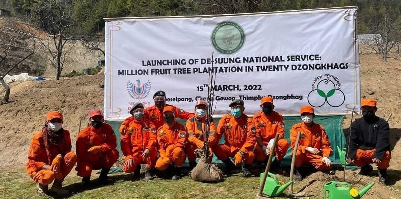
The photo is from the Official Facebook page of Desuung (Guardians of Peace) taken during the launch of the million fruit trees plantation and geocoding that followed after a year. (Desuung Facebook Page)

Geocoding of Million Fruit Trees for Monitoring and Tracking (Бутан)

Shingdrey Changm Saya Zukchong Tatok Gi Dhoen lu Sa Chhai Dhadhoen Dhulen (ཤིང་འབྲས་ལྕངམ་ས་ཡ་འཛུགས་སྐྱོང་བལྟ་རྟོག་གི་དོན་ལུ་ས་ཆའི་བརྡ་དོན་བསྡུ་ལེན།)

Тодорхойлолт

Geocoding of fruit trees allows remote monitoring and progress tracking of the growth of seedlings. The Smart App MoDA (Mobile Operation and Data Acquisition) is used in geocoding.

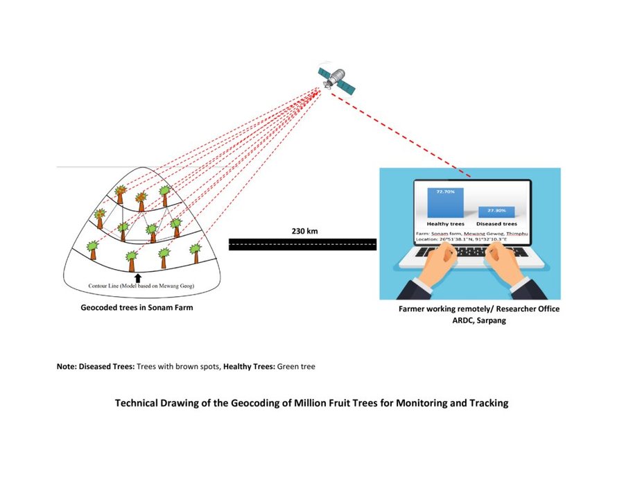
Geocoding of the “million fruit trees” initiative has been carried out across Bhutan. Different fruit trees suitable for particular agroecological zones were planted in farmers' fields in twenty districts and each sapling was geocoded.
The main elements of geocoding fruit trees involve assigning unique geographical codes or coordinates to individual trees within an orchard, utilizing technical specifications and equipment such as handheld GPS to accurately determine the location. The potential benefits of this form of geocoding include:
1. Location Mapping: Geocoding allows fruit trees to be accurately located on a map, providing a visual representation of their spatial distribution. This mapping can help identify patterns, clusters, and gaps in tree distribution.
2. Data Integration: Geocoded data can be integrated with geographic information systems (GIS) and other data sources, such as climate data, soil information, and topography. This integration provides a holistic view of the factors influencing fruit tree growth and productivity.
3. Precision: Geocoding provides precise coordinates for each fruit tree, enhancing the accuracy of data collection and analysis. This precision is crucial for making informed decisions regarding tree management and resource allocation.
4. Monitoring and Management: Geocoded fruit tree data enables efficient monitoring of tree health, growth, and potential issues. It facilitates targeted interventions, such as irrigation, fertilization, and pest control, based on the specific needs of individual trees or clusters.
5. Yield Estimation: By combining geocoded data with relevant environmental and growth information, it's possible to estimate the potential fruit yield in specific areas. This information aids in resource planning and harvest predictions.
6. Disease and Pest Management: Geocoded data can help identify patterns of disease or pest infestations. Early detection through geocoded monitoring can enable prompt intervention and prevent the spread of pests or diseases.
7. Biodiversity Analysis: Geocoding allows researchers to study the diversity of fruit tree species in different regions. This analysis can be useful for conservation efforts and understanding the ecological impact of specific tree species.
8. Research and Analysis: Geocoded fruit tree data serves as a valuable resource for scientific research. Researchers can study the effects of climate change, urbanization, and land use changes on fruit tree populations and ecosystems.
9. Decision-Making: Geocoded data assists farmers, agricultural agencies, and policymakers in making informed decisions about land use, tree planting initiatives, and resource allocation for sustainable agriculture.
10. Community Engagement: Geocoded maps of fruit trees can be shared with communities, promoting awareness of local resources, fostering community engagement, and encouraging initiatives like urban orchards or community gardens.
11. Data Visualization: Geocoded data can be visualized using maps and spatial tools, making it easier to interpret and communicate information to various stakeholders.
12. Long-Term Tracking: Geocoded data allows for long-term tracking of changes in fruit tree populations, aiding in the assessment of the success of planting initiatives and the overall health of the environment.
The major activity of the technology is marking the fruit trees with the help of GPS so that these geocoordinates can be useful in tracking down the exact location of the plant. Geocoding is labour-intensive as the field workers need to be physically present in the field while carrying out the activity. Then the data recorded in GPS is transferred to the computer and analyzed using ArcGIS. This information is available to the policymakers and Agriculture officers and is shared with the Extension Agents through which it is disseminated to the land users.

Байршил

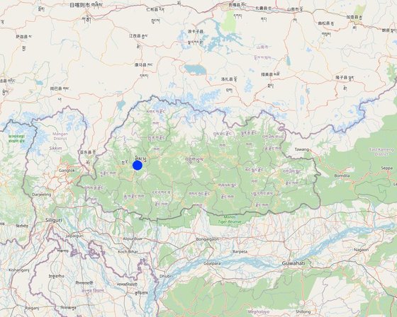
Байршил: Sigay Chiwog, Mewang Gewog, Thimphu Dzongkhag, Бутан

Дүн шинжилгээнд хамрагдсан технологи нэвтрүүлсэн газрын тоо: нэг байршилд

Сонгосон байршлуудын газарзүйн холболт
  • 449.58953, 27.39046

Технологийн тархалт: тодорхой газар хэрэгжсэн/ жижиг талбайд төвлөрсөн

Тусгай хамгаалалттай газар нутагт?: Үгүй

Хэрэгжилтийн огноо: 2022

Нутагшууллын төрөл
The photo was taken with the field extension supervisor. (Aum Tshogpa of Sigey Chiwog)

Технологийн ангилал

Үндсэн зорилго
  • үйлдвэрлэлийг сайжруулах
  • газрын доройтлыг бууруулах, сэргийлэх, нөхөн сэргээх
  • экосистемийг хамгаалах
  • сав газрыг хамгаалах (усны эх/ голын адаг) - бусад технологитой хослуулах
  • биологийн төрөл зүйлийг хамгаалах / сайжруулах
  • гамшгийн эрсдлийг бууруулах
  • уур амьсгалын өөрчлөлт/ экстрим байдал болон түүний нөлөөлөлд дасан зохицох
  • уур амьсгалын өөрчлөлт, түүний үр нөлөөг багасгах
  • үр ашигтай эдийн засгийн нөлөөг бий болгох
  • нийгэмд үзүүлэх үр нөлөөг бий болгох
Газар ашиглалт
Нэг газр нутгийн хэмжээнд хэрэгжих холимог газар ашиглалт: Тийм - ХАА-н ойжуулалт

  • Тариалангийн талбай
    • Нэг наст үр тариа: үр тариа - цагаан будаа (өндөр газрын). Cropping system: Чийгт газар цагаан будаа, улаан буудай сөөлжлөн тариалсан
    • Олон наст (модлог биш) үр тариа
    Жилд ургамал ургах улирлын тоо: 2
    Сөөлжлөн тариалалт хийгддэг үү? Тийм
    Таримлыг ээлжлэн тариалдаг уу? Тийм
Усан хангамж
  • Байгалийн усалгаатай
  • Байгалийн/усалгаатай арга хосолсон
  • бүрэн усалгаатай

Газрын доройтолтой холбоотой зорилго
  • газрын доройтлоос урьдчилан сэргийлэх
  • Газрын доройтлыг бууруулах
  • Хүчтэй доройтсон газрыг нөхөн сэргээх/ сайжруулах
  • газрын доройтолд дасан зохицох
  • холбогдолгүй
Доройтолын төрөл
  • хөрс усаар эвдрэх - Wt: Хөрсний гадаргын угаагдал, Wg: Гуу жалгын элэгдэл
  • хөрс салхиар эвдрэх - Et: Хөрсний гадаргын зөөгдөл
  • биологийн доройтол - Bc: Ургамлан нөмрөг багасах
ГТМ бүлэг
  • ХАА-н ойжуулалт
  • ургамлын сорт / малын үүлдэр сайжирсан
ГТМ арга хэмжээ
  • Ургамлын арга хэмжээ - V1: Мод ба бут, сөөг

Техникийн зураг

Техникийн үзүүлэлтүүд
The technical drawing represents the general method of million fruit tree plantation and geocoding done on each tree. It depicts how geocoding enables the researcher or farmer to remotely check the health of the trees using satellite data. ARDC stands for Agriculture Research and Development Center.
Author: Nima Dolma Tamang, Singye Dorji, Tshering Gyeltshen

Бий болгох ба арчилах: үйл ажиллагаа, материал ба зардал

Материал, зардлын тооцоо
  • Тооцоолсон зардлууд: Технологийн нэгж тус бүр (нэгж: No of Seedlings volume, length: 8000 seedlings (Only in Mewang Geog))
  • Зардал тооцоход ашигласан валют: Ngultrum (Bhutanese Currency)
  • Валютын ханш (ам.дол): 1 ам.дол = 82.62 Ngultrum (Bhutanese Currency)
  • Нэг өдрийн ажилчны хөдөлмөр хөлсний дундаж: 800
Зардалд нөлөөлөх хамгийн чухал хүчин зүйлс
Most important factors affecting the costs are seedling and labour cost.
Хэрэгжүүлж эхлэхэд шаардлагатай үйл ажиллагаа
  1. Meeting between Gewog leaders and land users (Хугацаа / давтамж: NA)
  2. Identified a village for planation (Хугацаа / давтамж: NA)
  3. Identified households that wanted the seedings and number of seedlings (Хугацаа / давтамж: NA)
  4. Site identification (Хугацаа / давтамж: NA)
  5. Orchard layout (Хугацаа / давтамж: NA)
  6. Pit digging (Хугацаа / давтамж: NA)
  7. Plantation (Хугацаа / давтамж: March- April)
  8. Basin making (Хугацаа / давтамж: After planation)
  9. Geocoding (Хугацаа / давтамж: After one month of orchard establishment)
  10. Growth Tracking (Хугацаа / давтамж: After every six months)
Бий болгоход шаардагдах материал ба зардал (per No of Seedlings)
Зардлын нэр, төрөл Хэмжих нэгж Тоо хэмжээ Нэгжийн үнэ (Ngultrum (Bhutanese Currency)) Зардал бүрийн нийт өртөг (Ngultrum (Bhutanese Currency)) Нийт дүнгээс газар ашиглагчийн төлсөн %
Хөдөлмөр эрхлэлт
Desuup (Guardians of peace) - Volunteers Person-days 6.0
Farmers Person-days 10.0 800.0 8000.0 100.0
Тоног төхөөрөмж
Shovel No. 10.0 100.0
crow-bar No. 5.0 100.0
Spade No. 20.0 100.0
GPS remote No 6.0 12000.0 72000.0
Tabs/ mobile phones No. 6.0 15000.0 90000.0
таримал материал
Apple No. 3500.0 70.0 245000.0
Walnut No. 1000.0 120.0 120000.0
Almond No. 500.0 120.0 60000.0
Peach No. 1000.0 70.0 70000.0
Pear No. 2000.0 70.0 140000.0
Бордоо ба биоцид
Manure and fertillizers Metric Tonnes 16.0 1600.0 25600.0 100.0
Технологи бий болгох нийт үнэ өртөг 830'600.0
Технологи бий болгох нийт үнэ өртөг, ам.доллар 10'053.26
Арчилгаа, урсгал үйл ажиллагаа
  1. Weeding (Хугацаа / давтамж: Twice a year)
  2. Fertillizer application (Хугацаа / давтамж: Twice a year)
  3. Irrigation (Хугацаа / давтамж: Once a week)
  4. Replacement of dead plants (Хугацаа / давтамж: After 6 months from plantation)
  5. Growth tracking (Хугацаа / давтамж: After every six month)
Арчилгаа, урсгал үйл ажиллагаанд шаардагдах материал ба зардал (per No of Seedlings)
Зардлын нэр, төрөл Хэмжих нэгж Тоо хэмжээ Нэгжийн үнэ (Ngultrum (Bhutanese Currency)) Зардал бүрийн нийт өртөг (Ngultrum (Bhutanese Currency)) Нийт дүнгээс газар ашиглагчийн төлсөн %
Хөдөлмөр эрхлэлт
Weeding and fertilizer application Per year 4.0 1600.0 6400.0 100.0
Irrigation Litres
Geocoding per plant 8000.0
таримал материал
Replacement of plants per plant 10.0 70.0 700.0
Технологийн арчилгаа/урсгал үйл ажиллагаанд шаардагдах нийт үнэ өртөг 7'100.0
Технологи арчилах ба урсгал ажлын нийт үнэ өртөг, ам.доллар 85.94

Байгалийн нөхцөл

Жилийн дундаж хур тундас
  • < 250 мм
  • 251-500 мм
  • 501-750 мм
  • 751-1,000 мм
  • 1,001-1,500 мм
  • 1,501-2,000 мм
  • 2,001-3,000 мм
  • 3,001-4,000 мм
  • > 4,000 мм
Агро-уур амьсгалын бүс
  • чийглэг
  • чийглэг
  • хагас хуурай
  • хуурай
Уур амьсгалын үзүүлэлтүүд
Жилийн нийлбэр хур тундас мм: 2076.0
The rainfall data for Mewang Gewog is not available. The provided data is for Thimphu Dzongkhag as Mewang Gewog is under Thimphu Dzongkhag (Gewog is one of the geographic units below Dzongkhag). Thimphu falls under a temperate region and experiences minimal rainfall compared to the other parts of Bhutan. Thimphu had the wettest month in July with 497 mm and experienced the least rainfall in December with 5 mm.
Цаг уурын станцын нэр: National Center for Hydrology and Metoerology, Thimphu.
There are six Agro-ecological Zones (AEZ) in Bhutan and the current place of study falls under warm temperate zone which occurs between 1,800 – 2,500 m. Rainfall is low but the temperature is moderately warm in summer with frost in winter.
Налуу
  • хавтгай (0-2 %)
  • бага зэрэг налуу (3-5 %)
  • дунд зэрэг налуу (6-10 % )
  • хэвгий (11-15 %)
  • налуу (16-30 %)
  • их налуу (31-60 % )
  • эгц налуу (>60 %)
Гадаргын хэлбэр
  • тэгш өндөрлөг / тал
  • нуруу
  • уулын энгэр
  • дов толгод
  • бэл
  • хөндий
Далайн түвшнөөс дээшхи өндөр
  • 0-100 д.т.д. м.
  • 101-500 д.т.д. м.
  • 501-1,000 д.т.д м.
  • 1,001-1,500 д.т.д м.
  • 1,501-2,000 д.т.д м.
  • 2,001-2,500 д.т.д. м.
  • 2,501-3,000 д.т.д. м.
  • 3,001-4,000 д.т.д м.
  • > 4,000 д.т.д. м.
Технологийг нэвтрүүлсэн
  • гүдгэр нөхцөл
  • хотгор нөхцөл
  • хамааралгүй
Хөрсний зузаан
  • маш нимгэн (0-20 см)
  • нимгэн (21-50 см)
  • дунд зэрэг зузаан (51-80 см)
  • зузаан (81-120 cм)
  • маш зузаан (>120 cм)
Хөрсний бүтэц (өнгөн хөрс)
  • бүдүүн/ хөнгөн (элсэрхэг)
  • дундаж (элсэнцэр, шавранцар)
  • нарийн /хүнд (шаварлаг)
Хөрсний бүтэц (гадаргаас доош > 20 см)
  • бүдүүн/ хөнгөн (элсэрхэг)
  • дундаж (элсэнцэр, шавранцар)
  • нарийн /хүнд (шаварлаг)
Өнгөн хөрсний ялзмагийн хэмжээ
  • их (>3 %)
  • дунд (1-3 % )
  • бага (<1 % )
Гүний усны түвшин
  • гадаргаас
  • < 5 м
  • 5-50 м
  • > 50 м
Гадаргын усны хүртээмж
  • хангалттай
  • сайн
  • дунд зэрэг
  • хангалтгүй/ байхгүй
Усны чанар (боловсруулаагүй)
  • сайн чанарын ундны ус
  • муу чанарын ундны ус (цэвэршүүлэх шаардлагатай)
  • зөвхөн газар тариалангийн зориулалтаар ашиглах (усалгаа)
  • ашиглах боломжгүй
Усны чанар гэж: гадаргын ус
Усны давсжилтын түвшинийг орчны асуудал гэж тооцдог уу?
  • Тийм
  • Үгүй

Үерийн давтамж
  • Тийм
  • Үгүй
Зүйлийн олон янз байдал
  • Их
  • дунд зэрэг
  • Бага
Амьдрах орчны олон янз байдал
  • Их
  • дунд зэрэг
  • Бага

Технологи нэвтрүүлсэн газар ашиглагчдын тодорхойлолт

Зах зээлийн чиг хандлага
  • амь зуух арга хэлбэрийн (өөрийгөө хангах)
  • холимог (амьжиргаа ба худалдаанд)
  • худалдаа наймааны/ зах зээлийн
Орлогын бусад эх үүсвэр
  • Нийт орлогын 10 %-иас доош
  • Нийт орлогын 10-50 %
  • Нийт орлогын 50 %-иас дээш
Чинээлэг байдлын түвшин
  • нэн ядуу
  • ядуу
  • дундаж
  • чинээлэг
  • маш чинээлэг
Механикжуулалтын түвшин
  • гар ажил
  • ердийн хөсөг
  • механикжсан / мотортой
Суурин эсвэл нүүдлийн
  • Суурьшмал
  • Хагас-нүүдэлийн
  • Нүүдэлийн
Хувь хүн эсвэл бүлгүүд
  • Хувь хүн / өрх
  • бүлэг / олон нийтийн
  • хоршоо
  • ажилтан (компани, засгийн газар)
Хүйс
  • эмэгтэй
  • эрэгтэй
Нас
  • хүүхэд
  • залуус
  • дунд нас
  • ахимаг нас
Өрхийн зориулалтаар ашиглах газрын талбай
  • < 0.5 га
  • 0.5-1 га
  • 1-2 га
  • 2-5 га
  • 5-15 га
  • 15-50 га
  • 50-100 га
  • 100-500 га
  • 500-1,000 га
  • 1,000-10,000 га
  • > 10,000 га
Хэмжээ
  • бага-хэмжээний
  • дунд-хэмжээний
  • том-хэмжээний
Газар өмчлөл
  • төрийн
  • компани
  • нэгдлийн/ тосгон
  • бүлэг
  • хувь хүн, өмчийн гэрчилгээгүй
  • хувь хүн, өмчийн гэрчилгээтэй
Газар ашиглах эрх
  • нээлттэй хүртэх (зохион байгуулалтгүй)
  • нэгдлийн хэлбэрээр (зохион байгуулалттай)
  • түрээсийн хэлбэрээр
  • хувь хүн
Ус ашиглах эрх
  • нээлттэй хүртэх (зохион байгуулалтгүй)
  • нэгдлийн хэлбэрээр (зохион байгуулалттай)
  • түрээсийн хэлбэрээр
  • хувь хүн
Дэд бүтэц, үйлчилгээний хүртээмж
эрүүл мэнд

ядуу
x
сайн
боловсрол

ядуу
x
сайн
техник зөвлөгөө

ядуу
x
сайн
хөдөлмөр эрхлэлт (жишээ нь, ХАА-аас өөр)

ядуу
x
сайн
зах зээл

ядуу
x
сайн
эрчим хүчний хангамж

ядуу
x
сайн
зам тээвэр

ядуу
x
сайн
усан хангамж ба ариутгал

ядуу
x
сайн
санхүүгийн үйлчилгээ

ядуу
x
сайн
Internet

ядуу
x
сайн
Тайлбар

The drinking water is insufficient as some households face scarcity of drinking water.

Нөлөө

Нийгэм-эдийн засгийн үр нөлөө
Үр тарианы ургац
буурсан
x
нэмэгдсэн


The technology aids in the monitoring and improves health and ease management of the already established orchard. Therefore, it indirectly increases crop production.

үр тарианы чанар
буурсан
x
нэмэгдсэн


Remote or constant monitoring ensures timely management to prevent biotic and abiotic factors deteriorate the crop quality.

тэжээл үйлдвэрлэл
буурсан
x
нэмэгдсэн

тэжээлийн чанар
буурсан
x
нэмэгдсэн

бүтээмж буурах эрсдэл
Нэмэгдсэн
x
Буурсан


Geocoding enables land user to determine potential risk so that the land user can use appropriate methods to prevent crop failure.

бүтээгдэхүүний олон янз хэлбэр
буурсан
x
нэмэгдсэн


The technology is not directly related to the product diversity. However, it provides data on existing fruit tree diversity so that the land user can plan and plant different fruit trees based on the market need which indirectly increases diversity.

бүтээмжит талбай (ашиглалт/тарилт хийгдэх талбай)
буурсан
x
нэмэгдсэн


Geocoding enables the land user to remotely view the cropped area and the area where the crop failed (could be due to dying of the seedlings/diseased). It enables the land user to narrow their focus on the specific area, learn about the issues causing the crop loss, provide appropriate management, and conduct plantation in that area which indirectly increases production area.

тариалангийн усалгааны усны хүртээмж
буурсан
x
нэмэгдсэн


Due to increased production area with no increase in the quantity of irrigation water, water availability is likely to reduce.

тариалангийн усалгааны усны хэрэгцээ
Нэмэгдсэн
x
Буурсан


There is increased demand for irrigation water for new plantations. However, with the use of technology land users can monitor the water requirement and use efficiently based on the need of the tree whereby the land users can avoid watering the trees that require less water and provide to those that require more water.

ХАА-н зардал
Нэмэгдсэн
x
Буурсан


Minimal increase in expenses on agriculture inputs as planting materials (except manure) were provided to the land users for free of cost.

тухайн аж ахуйн орлого
буурсан
x
нэмэгдсэн


Once the fruit trees starts bearing fruits, income is expected to increase.

эдийн засгийн ялгаат байдал
Нэмэгдсэн
x
Буурсан


The technology is expected to reduce economic disparity by providing equal opportunity for the land users to generate income.

ажлын хэмжээ
Нэмэгдсэн
x
Буурсан


Workload for the project implementors or land users are significantly reduced as they need not go to the actual site to determine the progress of the Million Fruit Trees Plantation Project.

Нийгэм-соёлын үр нөлөө
хүнсний аюулгүй байдал/ өөрийн хэрэгцээг хангах
буурсан
x
сайжирсан


The technology indirectly aids in the increased production making an individual land user and the nation self-sufficient in fruits.

амралт, рекреацийн боломжууд
буурсан
x
сайжирсан


With reduced workload, land users can engage in recreational activities.

ГТМ/ газрын доройтлын мэдлэг
буурсан
x
сайжирсан


The technology will enable the project implementors to determine specific knowledge gaps and provide training in that particular field to the land users. Improving knowledge of both project implementors and land users.

нийгэм, эдийн засгийн эмзэг бүлгүүдийн нөхцөл байдал (жендер, нас, төлөв, яс үндэс г.м.)
муудсан
x
сайжирсан


Land users willing to be involved in fruit tree plantation are supported without discrimination of their social status or economic background and geocoding services are provided. This leads to the improved situation of socially and economically disadvantaged groups.

Экологийн үр нөлөө
усны хэмжээ
буурсан
x
нэмэгдсэн


The total water quantity remains same. However, the available water per tree or sapling is reduced.

гадаргын урсац
Нэмэгдсэн
x
Буурсан


Due to the absorption of water by the roots of the fruit trees, surface run-off is decreased.

ууршилт
Нэмэгдсэн
x
Буурсан


Evaporation will be decreased due to an increase in the vegetation cover from the plantation of the fruit trees.

хөрсний чийг
буурсан
x
нэмэгдсэн


Slight increase in the soil moisture in long run due to addition of soil organic matter and monitored irrigation.

хөрсөн бүрхэвч
буурсан
x
сайжирсан


The technology enhances easy monitoring of the trees and encourages increased soil cover.

хөрс алдагдах
Нэмэгдсэн
x
Буурсан


The technology enhances soil cover reducing the soil loss from erosion.

шимт бодисын эргэлт/ сэргэлт
буурсан
x
нэмэгдсэн


Geocoding enables the land user to have overview of the nutrient content of the production area aiding land users to add nutrient based on the need.

хөрсний органик нэгдэл/ хөрсөнд агуулагдах карбон
буурсан
x
нэмэгдсэн


Generally, there will be an increase in the soil organic matter due to an increase in production area and management practice such as the addition of manures by the land user.

ургамалан нөмрөг
буурсан
x
нэмэгдсэн


Increase due to the scheduled irrigation applied to the fruit trees.

газрын дээрхи / доорхи карбон
буурсан
x
нэмэгдсэн


Slight increase due to proper management and care provided to the orchard.

амьтны төрөл, зүйл
буурсан
x
нэмэгдсэн


Animal diversity in the case of pollinators such as bees increases as the fruit trees mature and start flowering.

ашигт төрөл, зүйл (махчин, шимт хорхой, тоос хүртээгчид)
буурсан
x
нэмэгдсэн


Beneficial species such as bees are attracted to the orchards.

хортон шавж/өвчний хяналт
буурсан
x
нэмэгдсэн


Pest and diseases control improves with the use of remote monitoring facilitated by this technology.

хөрсний гулсалт/ чулуун нуранги
Нэмэгдсэн
x
Буурсан


Once the fruit trees establish themselves, landslides can be reduced significantly due to vegetation cover.

нүүрстөрөгч ба хүлэмжийн хийн ялгаруулалт
Нэмэгдсэн
x
Буурсан


This technology could potentially reduce greenhouse gas as trees utilize carbon dioxide for photosynthesis.

салхины хурд
Нэмэгдсэн
x
Буурсан


In the long run, a well-established orchard can act as a windbreak and reduce wind velocity and damage it poses to the property.

бичил уур амьсгал
муудсан
x
сайжирсан


An orchard can act as a micro-climate harbouring many plants and insect species.

Зэргэлдээ талбайд илрэх нөлөө
усны хүртээмж (гүний, гадаргын, булаг шандын)
буурсан
x
нэмэгдсэн


Fruit trees require irrigation which reduces the availability of water for other purposes.

хүлэмжийн хийн нөлөө
Нэмэгдсэн
x
багассан


Having a land cover with vegetation compared to barren land reduces greenhouse gases.

Өртөг ба ашгийн шинжилгээ

Бий болгох зардалтай харьцуулахад олсон ашиг
Богино хугацаанд эргэн төлөгдөх байдал
маш сөрөг
x
маш эерэг

Урт хугацаанд эргэн төлөгдөх байдал
маш сөрөг
x
маш эерэг

Урсгал зардалтай харьцуулахад олсон ашиг
Богино хугацаанд эргэн төлөгдөх байдал
маш сөрөг
x
маш эерэг

Урт хугацаанд эргэн төлөгдөх байдал
маш сөрөг
x
маш эерэг

Although the initial establishment of the orchard is costly considering the labour charge, it is expected to have positive income and impact once the fruit trees start bearing.

Уур амьсгалын өөрчлөлт

Уур амьсгалын аажим өөрчлөлт
жилийн дундаж температур Өсөлт

маш муу
x
маш сайн
улирлын температур Өсөлт

маш муу
x
маш сайн
Улирал: зун
жилийн дундаж хур тундас Өсөлт

маш муу
x
маш сайн
улирлын хур тундас Бууралт

маш муу
x
маш сайн
Улирал: зун
Уур амьсгалаас хамаарах аюул (гамшиг)
орон нутгийн мөндөртэй бороо

маш муу
x
маш сайн
цар тахал

маш муу
x
маш сайн

Нутагшуулах ба дасан зохицох

Тухайн нутаг дэвсгэрт Технологийг нэвтрүүлсэн газар ашиглагчдын хувь
  • жишээ/ туршилт
  • 1-10 %
  • 11-50%
  • > 50%
Технологийг нэвтрүүлсэн бүх хүмүүсийн хэд нь материаллаг урамшуулал авалгүйгээр технологийг хэрэгжүүлсэн бэ?
  • 0-10%
  • 11-50%
  • 51-90%
  • 91-100%
Хамрагдсан өрх ба/эсвэл газар нутгийн хэмжээ
Total 8000 fruit trees are planted in the five Chiwogs (third level administrative division under Gewog) under Mewang Gewog.
Технологи нь өөрчлөгдөж буй нөхцөл байдалд дасан зохицохын тулд өөрчлөгдсөн үү?
  • Тийм
  • Үгүй
Ямар өөрчлөлтөнд эмзэг вэ?
  • уур амьсгалын өөрчлөлт/ экстрим үзэгдэл
  • зах зээлийн өөрчлөлт
  • ажил хөдөлмөр эрхлэх боломж (ж.нь шилжих хөдөлгөөний улмаас)

Дүгнэлт, сургамж

Давуу тал: газар ашиглагчийн бодлоор
  • 1. Precision Mapping: Geocoding allows for accurate mapping and identification of fruit trees. By assigning specific geographic coordinates to each tree, it becomes easier to locate and monitor individual trees or orchards.
  • 2. Efficient Resource Allocation: Geocoding helps optimize resource allocation by providing information on tree density and distribution. Land users can identify areas with high fruit tree concentrations and strategically allocate resources such as labour, water, fertilizers, and pesticides, leading to improved productivity and reduced costs.
  • 3. Data-driven Decision Making: Geocoded data on fruit trees can be analyzed to gain insights into their distribution patterns, growth rates, and health status. This information enables land users, researchers, and policymakers to make informed decisions regarding fruit tree cultivation, pest control, and disease management.
Давуу тал: эмхэтгэгч эсвэл бусад мэдээлэл өгсөн хүмүүсийн бодлоор
  • 1. Conservation and Biodiversity Analysis: Geocoded fruit tree data aids in the conservation and analysis of biodiversity. By mapping the locations of different fruit tree species, experts can assess the distribution and abundance of specific varieties, identify endangered local or traditional landraces varieties, and develop strategies for their preservation.
  • 2. Targeted Marketing and Distribution: Geocoded fruit tree data facilitates targeted marketing and distribution strategies. By understanding the location of fruit trees and their yields, producers can identify potential markets and plan transportation logistics more effectively, minimizing waste and ensuring timely delivery to consumers.
Сул тал/ дутагдал / эрсдэл: газар ашиглагчийн бодлоордаван туулах боломжууд
  • Geocoding large numbers of fruit trees can be a time-consuming and resource-intensive task, particularly when manual processes are involved. It may require extensive fieldwork and manual data entry, making it impractical or costly for large-scale fruit tree inventories.
  • Privacy Concerns: Geocoding fruit trees raises privacy concerns, particularly when tree locations are associated with specific individuals or properties. Care must be taken to ensure that privacy is respected and sensitive information is appropriately handled An updated and secured security-protected website can be used.
  • Lack of knowledge of geocoding by the farmers. Provide awareness trainings
Сул тал/ дутагдал / эрсдэл: эмхэтгэгч эсвэл бусад мэдээлэл өгсөн хүмүүсийн бодлоордаван туулах боломжууд
  • The higher expense of the geocoding in terms of labour cost for geo-coding Train land users on geocoding, instead of using trained professionals.
  • Difficult to constantly update information on time.

Суурь мэдээлэлүүд

Эмхэтгэгч
  • Nima Dolma Tamang
Хянан тохиолдуулагчид
  • Haka Drukpa
Хянагч
  • William Critchley
  • Rima Mekdaschi Studer
  • Joana Eichenberger
Баримтжуулсан огноо: 06 7-р сар 2023
Сүүлийн шинэчлэл: 30 5-р сар 2024
Мэдээлэл өгсөн хүн
WOCAT мэдээллийн сан дахь бүрэн тодорхойлолт
Холбогдох ГТМ мэдээлэл
Баримтжуулалтыг зохион байгуулсан
Байгууллага Төсөл
Гол сурвалж баримт сэлт
  • De-suung National Service (DNS). (n.d.). Million Fruit Trees Plantation: https://desuung.org.bt/25978-2/#:~:text=In%20order%20to%20monitor%20the,from%20the%20date%20of%20plantation.
Холбогдох мэдээллийн интернет холбоос
This work is licensed under Creative Commons Attribution-NonCommercial-ShareaAlike 4.0 International