Integrated Pasture Management Planning in Mountainous Regions [Гүрж ]
- Шинийг нээх:
- Шинэчлэх:
- Мэдээлэл цуглуулсан: Hanns Kirchmeir
- Редакторууд: Natia Kobakhidze, Christian Goenner, Jonathan Etzold
- Хянагч: Rima Mekdaschi Studer
approaches_5490 - Гүрж
Бүлгүүдийг үзэх
Бүгдийг харуулах Бүгдийг хаах1. Ерөнхий мэдээлэл
1.2 Арга барилыг баримтжуулах болон үнэлгээ хийхэд оролцсон хүн эсвэл байгууллагын холбоо барих хаяг
ГТМ мэргэжилтэн :
co-compiler:
ГТМ мэргэжилтэн :
Арга барилыг баримтжуулах/үнэлэх ажилд дэмжлэг үзүүлсэн төслийн нэр (шаардлагатай бол)
Integrated Biodiversity Management, South Caucasus (IBiS)Арга барилыг баримтжуулах/үнэлэх ажилд дэмжлэг үзүүлсэн байгууллага(ууд)-ын нэр (шаардлагатай бол)
Deutsche Gesellschaft für Internationale Zusammenarbeit (GIZ)1.3 WOCAT-аар баримтжуулсан өгөгдлийг ашиглахтай холбоотой нөхцөл
Мэдээллийг хэзээ (газар дээр нь) цуглуулсан бэ?
01/02/2016
Эмхэтгэгч болон гол мэдээлэгч хүн(хүмүүс) WOCAT аргачлалаар баримтжуулсан мэдээллийг ашиглахтай холбоотой нөхцлийг хүлээн зөвшөөрсөн.
Тийм
1.4 ГТМ-ийн технологийн асуулгын(д) суурь мэдээлэл(д)
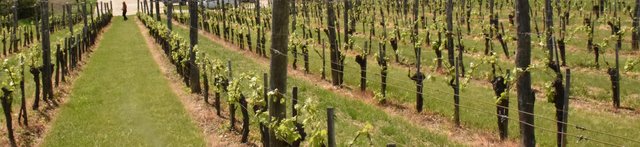
Permanent grass cover in vineyards [Унгар]
Permanent grass cover under grape vines protects the soil surface against erosion and compaction - and provides better conditions for traffic within the rows during mechanised field operations
- Мэдээлэл цуглуулсан: Brigitta Szabó
Remote Sensing as a Tool for Land Degradation … [Гүрж ]
Land degradation contributes to biodiversity loss and the impoverishment of rural livelihoods in Tusheti. Above all, however, land degradation are triggered by climate change as traditional land use practise might not be adapted to new climate conditions which can cause or speed up degradation processes significantly. On the other hand, …
- Мэдээлэл цуглуулсан: Hanns Kirchmeir
2. ГТМ Арга барилын тодорхойлолт
2.1 Арга барилын товч тодорхойлолт
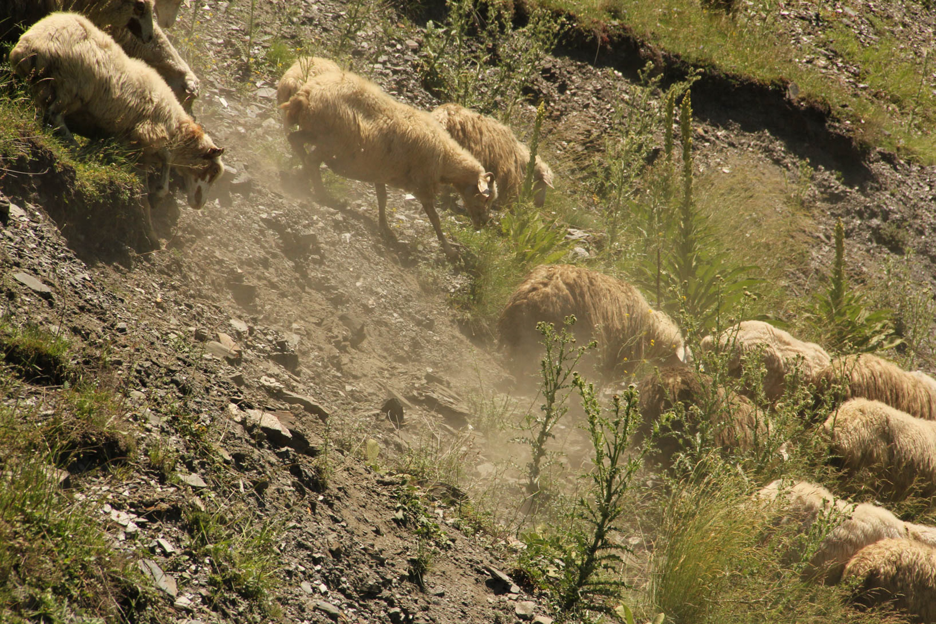
The unsustainable use of pastures and forest areas has led to soil erosion, degradation, desertification and loss of biodiversity in the high mountain areas of the South Caucasus. The development of pasture passports is part of a broader approach to a strategic pasture management plan for Tusheti. This showcase includes results from the spatial planning process applied in a pilot programme for Akhmeta municipality.
2.2 Арга барилын дэлгэрэнгүй тодорхойлолт
Арга барилын дэлгэрэнгүй тодорхойлолт :
Project area and purpose
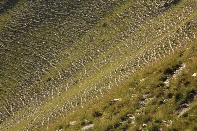
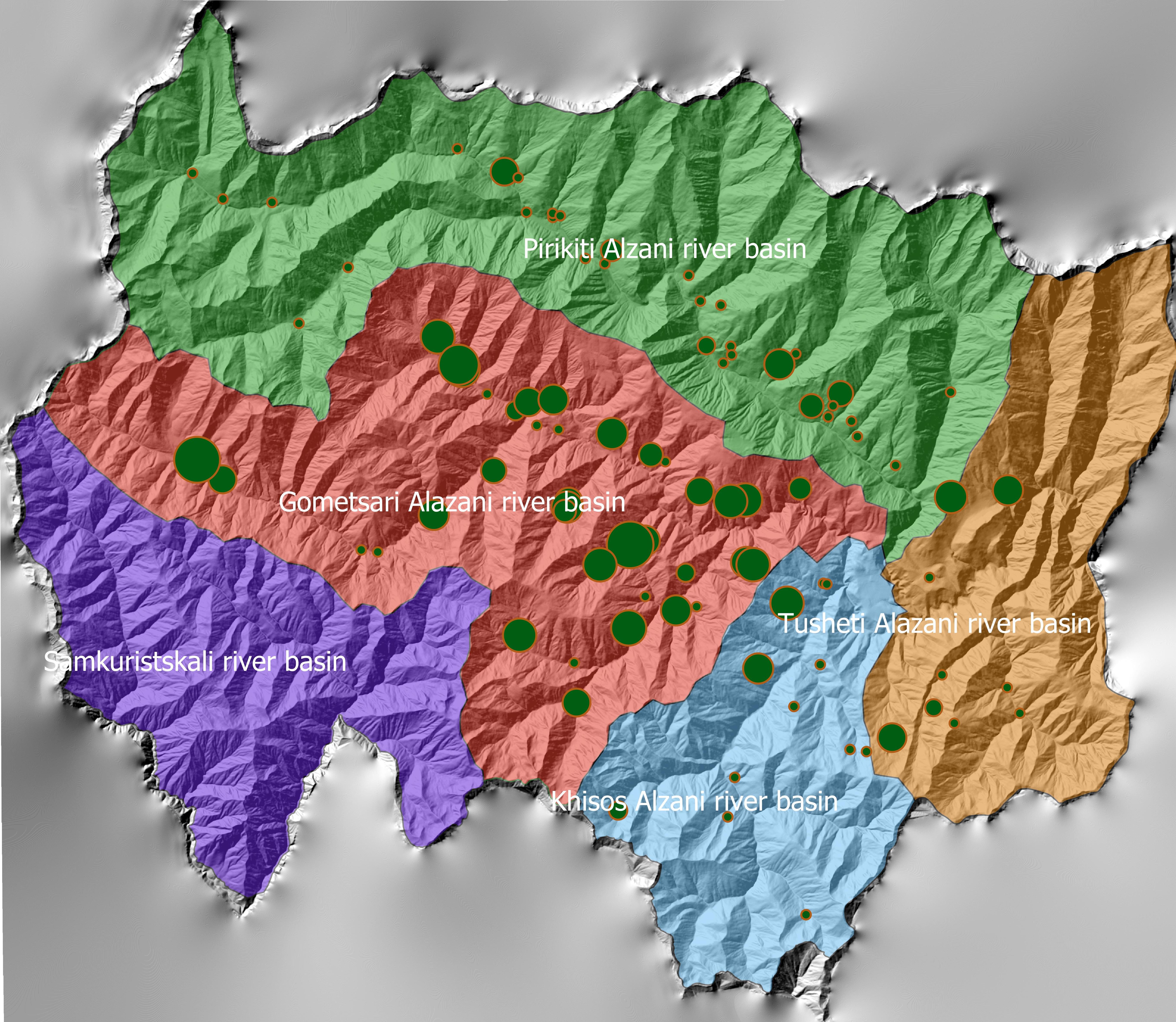
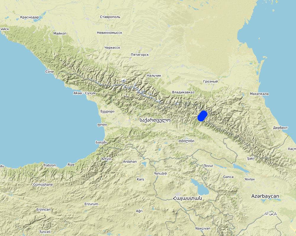
The project area comprises the Tusheti Protected Areas (PAs) on the northern slopes of the Greater Caucasus Mountains in Georgia. This group of protected areas consists of a strict nature reserve, a national park and a protected landscape with about 40 villages and settlements. Together they form a total protected area of approx. 114,000 ha. In Tusheti, overgrazing has led, especially in the eastern part with a higher number of villages and roads, to soil erosion and biodiversity loss. Especially the intensive use of summer pastures during the Soviet period resulted in a severe deterioration of the mountain slopes. So far, there are no standards or guidelines for the elaboration of sustainable pasture management plans in Georgia. Pasture passports, as a first step towards sustainable pasture management, document the actual grazing capacity for each pasture unit and serve as a guiding document for shepherds and local stakeholders and as a basis to prepare lease contracts.
Data gathering
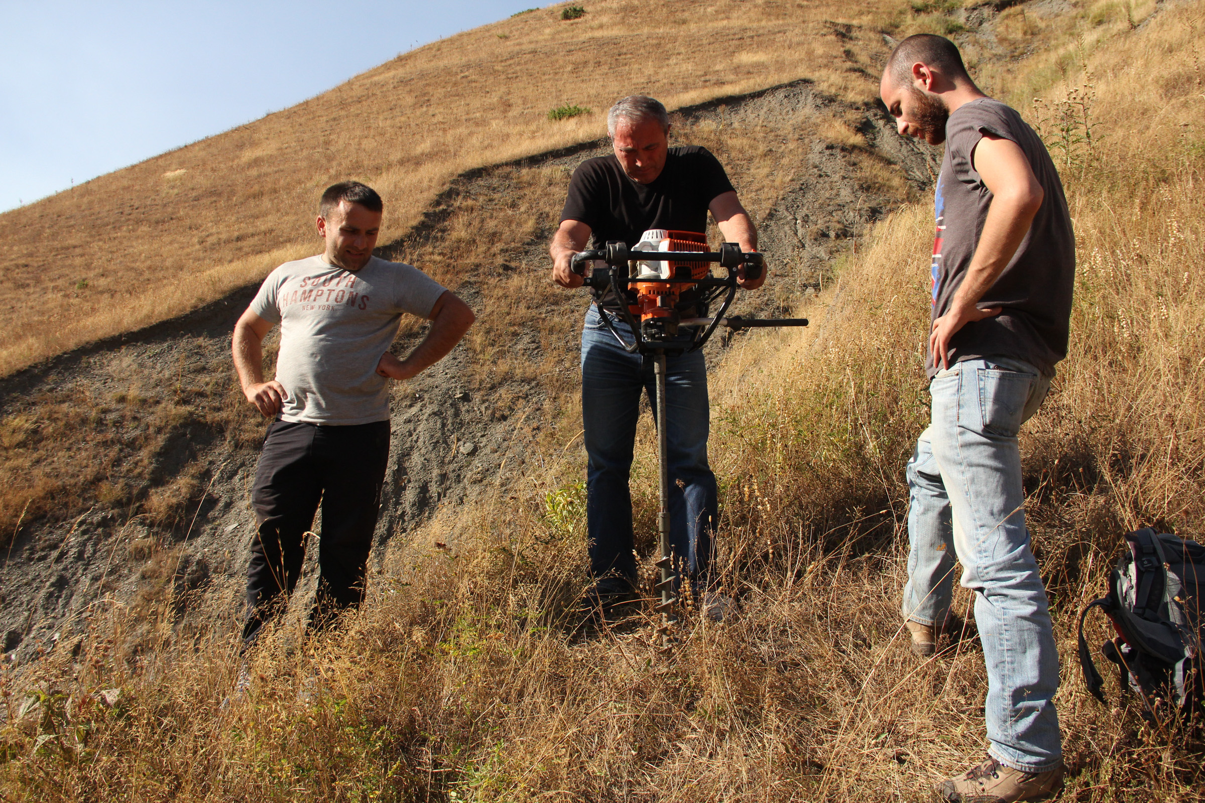
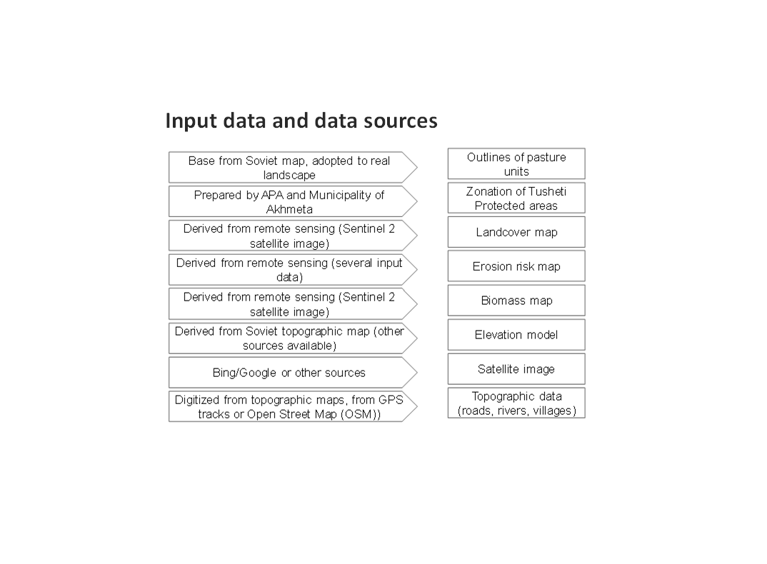
As a prerequisite for the development of pasture passports and the calculation of grazing capacity, the type of land cover, the erosion risk and the biomass of the pastureland had to be assessed for each pasture unit. This was done using remote sensing tools in combination with data collected in the field for calibration.
The details on the methodology of the Land Cover & Biomass as well as the Erosion Risk Assessment can be found in the WOCAT technology on "Remote Sensing as a Tool for Land Degradation Neutrality Monitoring" (see link).
Evaluation and Ground Truthing
All interim results have been checked and evaluated by local stakeholders, national experts and experts from local administrations. It was important not only to conduct workshops in seminar rooms but to meet the local stakeholders in the field and to discuss the problems and challenges of pasture management on place in the field. At this workshops all levels of decision makers were included (Ministries, Donor organisations, international and national experts, local administrations and land users). This was important to create a common understanding of the current situation from different perspectives (nature conservation, administration, shepherds ...). The combination of remote sensing with calibration data from the field can be summarised as a very effective method to assess the erosion state in large areas. Neither of the two instruments would be able to provide results in this spatial dimension and quality alone.
Pasture Passports
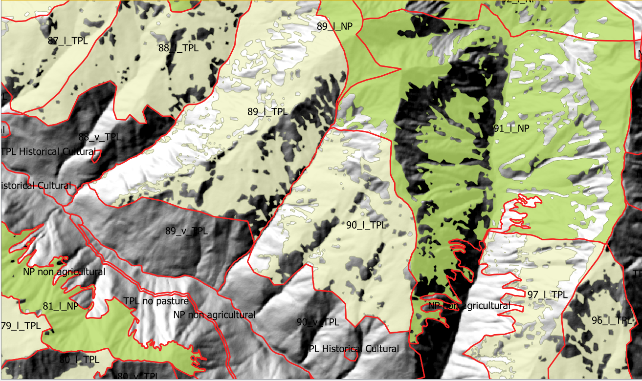
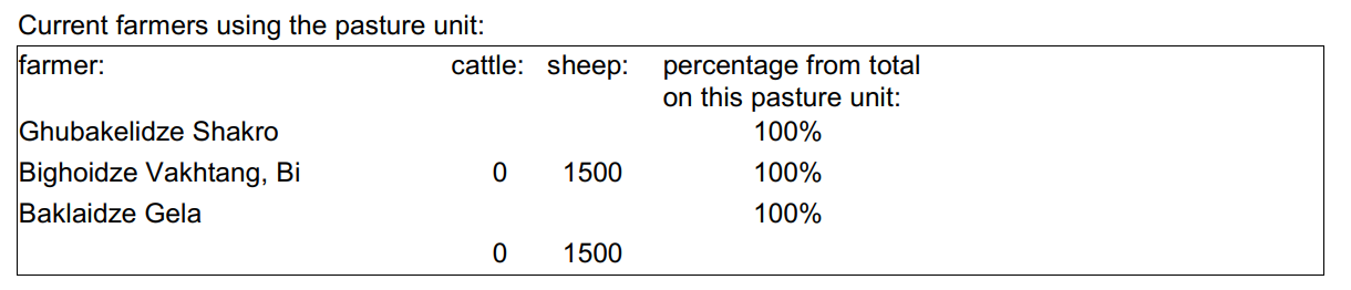
As part of the spatial planning of Akhmeta municipality, pastureland that can be leased to shepherds was separated from land used as hay meadows, farmland or pastures belonging to the villagers. The resulting map shows land available to the village and land available for lease. To understand the current use of pastureland, farms, livestock numbers and pasture units were assessed. In workshops with the local stakeholders and potential users of the results (shepherds, Tusheti Protected Landscape Administration, Tusheti NP Administration, APA), the design of the pasture passports was developed. Each pasture unit is described on four pages in the pasture passport.
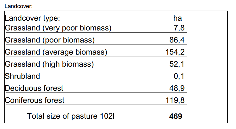
Each pasture unit is described on four pages in the pasture passport: Header: the number (code), total area; content: map of the land cover types, the area of each land cover type, map of available biomass and carrying capacity, name of farmers/shepherds and their livestock numbers using the pasture unit
Spatial Planning Department and Construction Policy (within the Ministry of Regional Development and Infrastructure MRDI), and the Agency of Protected Areas APA (within the Ministry of Environmental Protection and Agriculture MEPA), are key stakeholders to use the pasture passports and to further develop and upscale this approach to other protected areas in Georgia. Beside APA, the Tusheti Protected Landscape Administration (TPLA), located within the Akhmeta municipality administration, is the second important user of pasture passports.
The pasture passports are showing not only the boundaries of each pasture unit, but also those areas that must not be grazed because this lands are part of strict protected areas or areas of high erosion risk. This helps shepherds to guide their flocks to the right places and the park rangers to check, if the regulations are respected correctly.
2.3 Арга барилын зурагууд
Медиа галерей
2.5 Арга барил нэвтрүүлсэн улс орон / бүс нутаг / байршил
Улс :
Гүрж
Улс/аймаг/сум:
Tusheti
Байршлын дэлгэрэнгүй тодорхойлолт:
Entire territory of Tusheti Protected Areas (1100 km²)
Тайлбар:
Tusheti is located in the north-eastern of Georgia in the Higher Caucasus bordering Dagestan, Russia. The territory consists of the Tusheti Strict Nature Reserve (12,627 ha), Tusheti National Park (69,515 ha), and Tusheti Protected Landscape (31,517 ha), which includes around 40 villages and settlements.
Full territory of Tusheti Protected Areas (1100 km²)
Map
×2.6 Арга барилыг эхлэх, дуусах огноо
Эхлэх жилийг тэмдэглэ:
2016
2.7 Арга барилын төрөл
- төсөл / хөтөлбөр дээр үндэслэсэн
2.8 Арга барилын үндсэн зорилго, зорилтууд
Support land use planning and decision-making processes for better management of natural resources, especially pastures.
2.9 Арга барилын хүрээнд хэрэгжсэн Технологи/Технологиудад дэмжсэн эсвэл саад учруулсан нөхцлүүд
нийгэм / соёл / шашны хэм хэмжээ, үнэт зүйлс
- Идэвхижүүлэх
There is a strong identification of the local communities with the traditional pasture land use and the communities are willing to establish a long-term sustainable land management.
санхүүгийн нөөц, үйлчилгээний хүртээмж / боломж
- Хазаарлалт
Missing financial resources is hindering the implementation of the approach.
Бүтэц зохион байгуулалт
- Идэвхижүүлэх
Good cooperation between the relevant institutions on the national and municipal level enabled a successful implementation. The Agency of Protected Areas (APA) located at the Ministry of Environmental Protection and Agriculture (MEPA) and the Tusheti Protected Landscape Administration (TPLA), located within the Akhmeta municipality administration are responsible for contracting lease agreements with shepherds and should not only be able to understand the technology behind the passports but should also have the capacity to handle the technology to be able to adapt the passports if needed (e.g., by changing boundaries of pasture units). For this issue, training workshops with decision-makers and technicians from the MoEPA, APA with TNP Administration and Administration of Akhmeta Munucuaplity with TPLA have been implemented.
Collaboration/ coordination of actors: All relevant national and local authorities that are dealing with spatial or environmental data participated in the workshop to discuss the approach and institutional suitability to host the sensitivity modelSoil Erosion Risk Model.
талуудыг хамтын ажиллагаа/зохицуулалт
- Идэвхижүүлэх
All relevant national and local authorities that are dealing with spatial or environmental data participated in the workshop to discuss the approach and institutional suitability to host the Soil Erosion Risk Model.
ГТМ-ийн талаарх мэдлэг, техникийн дэмжлэг авах боломж
- Хазаарлалт
There is a high need for technical infrastructure and strong human capacity development.
3. Оролцогч талуудын оролцоо ба үүргүүд
3.1 Арга барилд оролцогч талууд болон тэдгээрийн үүргүүд
- Орон нутгийн газар ашиглагч / орон нутгийн иргэд
Shephards, local communities
Participation at the workshop/meeting and
making contributions through comments,
suggestions and sharing their analytical point
of view.
- ГТМ-ийн мэргэжилтэн/ хөдөө аж ахуйн зөвлөх
GIS-LAB (Georgian scientific GIS service provider)
National experts on remote sensing and modelling of erosion risk.
- Судлаачид
National ecologists from universities
- ТББ
Centre for Biodiversity Research & Conservation (NACRES);
staff and experts from FATPA (Friends Association of Tusheti Protected Areas);
local NGO's
Interviews with local stakeholders, field experts
- Орон нутгийн захиргаа
Municipality of Akhmeta and Tusheti Protected Landscape Management
Participation at the workshop where they have given input and made contributions to the topic of technical aspects of the approach.
- Засгийн газар (шийдвэр гаргагч, төлөвлөгч)
National Park management and APA (Agency for Protected Areas)
Long term aplication and upscaling on national level.
- Олон улсын байгууллага
Deutsche Gesellschaft fuer Zusammenarbeit (GIZ)
Funding and supervision of the implementation process.
3.2 Арга барилын янз бүрийн үе шатанд орон нутгийн газар ашиглагчид / бүлэглэлүүдийг татан оролцуулах
| Орон нутгийн газар ашиглагч / орон нутгийн иргэдийн оролцоо | Хэн оролцсоныг тодорхойлж, үйл ажиллагааг тайлбарлана уу | |
|---|---|---|
| санаачлага/идэвхжүүлэлт | идэвхигүй | |
| Төлөвлөгөө | идэвхигүй | |
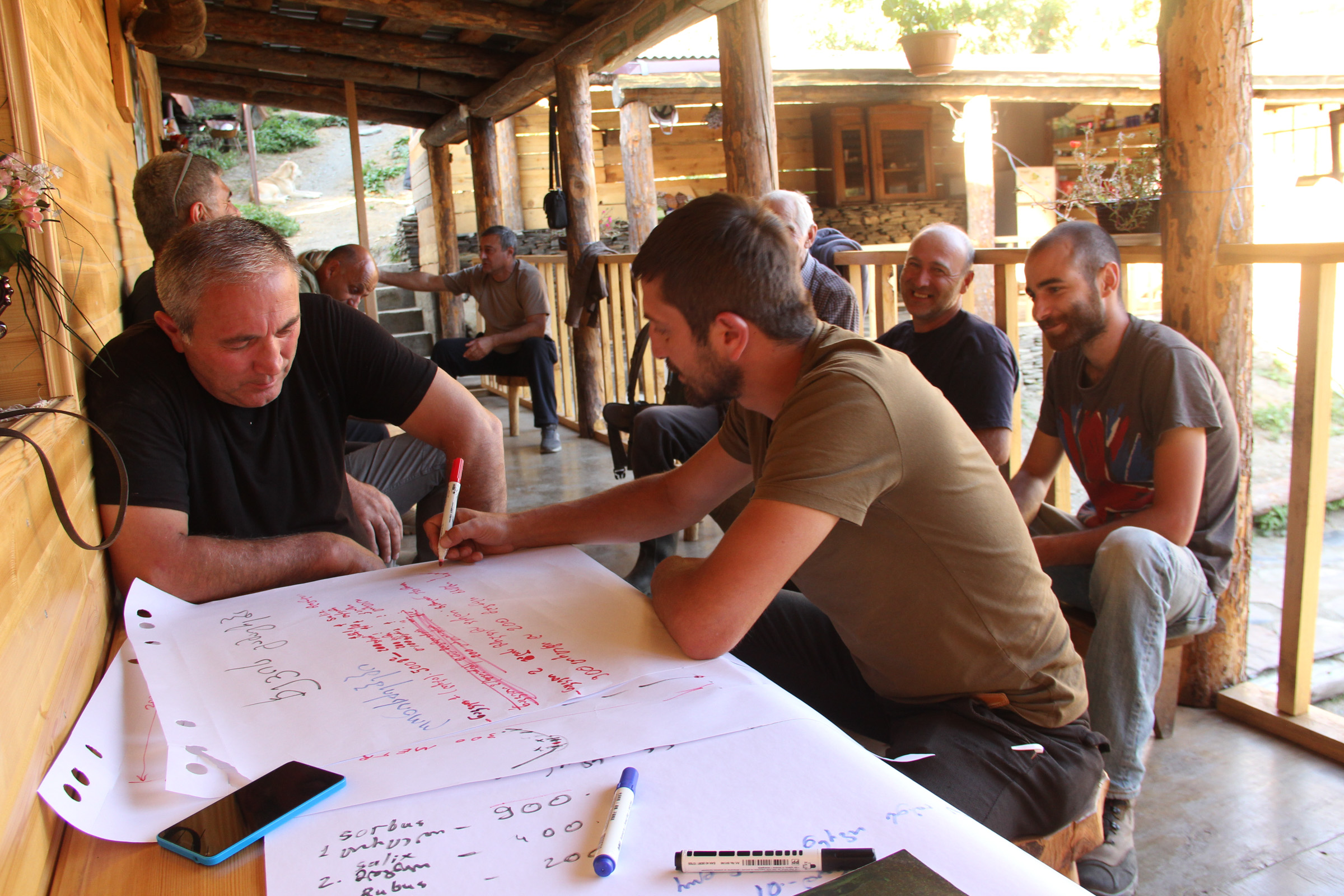
| Хэрэгжилт | интерактив | Organized meetings, workshop where stakeholders, local communities discussed different technical methodologies, visited the project communities and evaluated the preliminary result maps of erosion risk in the field. |
| Мониторинг/ үнэлгээ | идэвхигүй |
3.3 Диаграм (хэрэв боломжтой бол)
Тодорхойлолт :
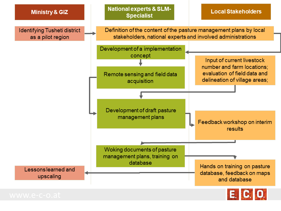
The process of generating pasture passports consists of several phases. The needs and expected content of the pasture management plans was defined in the early stage of the project by the local stakeholders, national experts and involved administrations. The preparation of the pasture management plans was an iterative process between the remotsensing and field sampling results and feedback and input from local stakeholders.
•
Зохиогч :
Hanns Kirchmeir
3.4 ГТМ-ийн технологи/технологиуд сонгох шийдвэр
Хэрэгжүүлэх Технологи/Технологиудын сонголтыг хийж шийдвэр гаргасан хүнийг тодорхойлно уу:
- голдуу ГТМ-ийн мэргэжилтнүүд, газар ашиглагчидтай зөвлөлдсөний үндсэн дээр
Шийдвэрийг юунд үндэслэн гаргасан:
- ГТМ-ийн мэдлэгийг баримтжуулалтын үнэлгээ (нотолгоонд суурилсан шийдвэр гаргах)
4. Техникийн дэмжлэг, чадавхи бүрдүүлэх, мэдлэгийн менежмент
4.1 Чадавхи бэхжүүлэх/сургалт
Газар эзэмшигчид / бусад оролцогч талуудад сургалт явуулсан уу?
Тийм
Хэн сургалтанд хамрагдсан бэ:
- хээрийн ажилтан / зөвлөх
Сургалтын хэлбэр :
- үзүүлэнгийн талбай
Сургалтын хэлбэр :
- workshop with field mission
Хамрагдсан сэвдүүд:
Evaluation of model results, preliminary result maps of erosion risk in the field, technical implementation of the sensitivity model in Georgia.
Тайлбар:
The workshops were combined with field missions to evaluate model results directly in the field. The expert teams went into the project communities and evaluated the preliminary result maps of erosion risk in the field together with local stakeholders.
4.2 Зөвлөх үйлчилгээ
Газар ашиглагчдад зөвлөх үйлчилгээ авах боломжтой байдаг уу?
Тийм
Зөвлөх үйлчилгээ үзүүлсэн эсэхийг тогтоо:
- Тогтмол төвд
Тодорхойлолт / тайлбар:
Located on district level in Telavi
4.3 Институцийг бэхжүүлэх (байгууллагын хөгжил)
Арга барилаар дамжуулан институц байгуулагдаж эсвэл бэхжсэн үү?
- Тийм, дунд зэрэг
Байгууллагууд бэхжиж, үүсэн бий болсон түвшин(үүд)-г тодорхойлно уу:
- Орон нутгийн
- Бүс нутгийн
- Үндэсний
Байгууллага, үүрэг, хариуцлага, гишүүд гэх мэтийг тайлбарлах:
The results of the approach implementation in Georgia has been summarized by the Programme ”Integrated Biodiversity Management, South Caucasus” and distributed to the experts in Azerbaijan for the further implementation.
Approach and results have been handed over to the local municipality responsible for the lease contracts in the Protected Landscape and to APA, which is responsible for the land use in the national park to integrate them into their pasture management plans.
Дэмжлэгийн төрлийг ялга:
- Санхүүгийн
- чадавхи бэхжүүлэх / сургалт
- sharing the concept, approach
Дэлгэрэнгүй мэдээллийг өгнө үү:
The concept and approach has been shared with local municipalities and other related experts.
Pilot study financed by GIZ.
4.4 Мониторинг ба үнэлгээ
Мониторинг болон үнэлгээ нь арга барилын хэсэг үү?
Тийм
Тайлбар:
Within the project a basline was drawn with the current livestock numbers, the current available fodder biomass and the current state of erosion.
Хэрэв тийм бол энэ баримт бичиг нь мониторинг, үнэлгээнд ашиглагдахаар зориулагдсан уу?
Тийм
Тайлбар:
The remote sensing technology enables a sound methodology to compare the state of erosion and the biomass volume based on satelite data after some years with the baseline values from 2017.
4.5 Судалгаа
Судалгаа арга барилын хэсэг нь байсан уу?
Тийм
Сэдвийг тодруулна уу:
- Технологи
Дэлгэрэнгүй мэдээллийг өгч, хэн судалгаа явуулсныг бичнэ үү:
National and international ecologists did research on vegetation details and biomass as well as on the remote sensing technology.
5. Санхүүгийн болон гадаад материаллаг дэмжлэг
5.1 ГТМ-ийн Арга барилын бүрэлдэхүүн хэсгийн жилийн төсөв
Хэрэв жилийн төсөв тодорхойгүй бол хягаарыг тодруулна уу:
- 10,000-100,000
Тайлбар (жнь: санхүүжилтийн гол эх үүсвэр / гол хандивлагчид):
The funds came from the Integrated Erosion Control project which aas launched as part of the Integrated Biodiversity Management, South Caucasus (IBiS) Programme of the Deutsche Gesellschaft für Internationale Zusammenarbeit (GIZ)
5.2 Газар ашиглагчдад санхүүгийн / материаллаг дэмжлэг үзүүлсэн
Технологи / технологийг хэрэгжүүлэхэд газар ашиглагчид санхүүгийн / материаллаг дэмжлэг авсан уу?
Үгүй
5.3 Тодорхой зардлыг даахад чиглэсэн дэмжлэгт (хөдөлмөрийн хүчийг оролцуулаад)
- үгүй
Хэрэв газар ашиглагчийн хөдөлмөрийн хүч чухал байсан бол энэ нь аль хэлбэр байсан:
- сайн дурын
Тайлбар:
There was a questionnaire and land-users shared their information on land-use practice.
5.4 Кредит
Арга барилын хүрээнд ГТМ-ийн үйл ажиллагаанд зориулж зээлд хамрагдсан уу?
Үгүй
5.5 Бусад урамшуулал, хэрэгсэл
ГТМ-ийн технологийг хэрэгжилтийг дэмжихэд ашигласан бусад урамшуулал, хэрэгсэл байсан уу?
Тийм
Хэрэв тийм бол, тодруулна уу:
The Agency of Protected Areas (APA) thinks about upscaling the pasture passport method on a national level and establish the approach also in other protected areas of Georgia.
6. Нөлөөллийн дүн шинжилгээ ба дүгнэлт
6.1 Арга барилын нөлөөллүүд
Арга барил нь орон нутгийн газар ашиглагчдыг чадваржуулах, оролцогч талуудын оролцоог сайжруулсан уу?
- Үгүй
- Тийм, бага зэрэг
- Тийм, зарим
- Тийм, их
Through the field visits and workshops, it has involved both experts and authorities, where they have assessed, analysed and given input.
Арга барил нь нотолгоонд суурилсан шийдвэр гаргах боломж олгосон уу?
- Үгүй
- Тийм, бага зэрэг
- Тийм, зарим
- Тийм, их
By the assessment of biomass, the carrying capacity of each pasture unit was calculated.
Арга барил нь ГТМ хэрэгжүүлэхэд газар ашиглагчдын мэдлэг, чадварыг сайжруулахад хүргэсэн үү?
- Үгүй
- Тийм, бага зэрэг
- Тийм, зарим
- Тийм, их
The perception of the key stakeholders and management towards the importance of biodiversity and ecosystem services has become more positive.
Энэ арга барил бусад сонирхогч талуудын мэдлэг, чадавхийг сайжруулсан уу?
- Үгүй
- Тийм, бага зэрэг
- Тийм, зарим
- Тийм, их
The implementation capacity of line ministries, their subordinate bodies and of training institutions regarding the management of biodiversity and ecosystem services is improved at the national level.
Арга барил нь оролцогч талуудын хооронд институци, хамтын ажиллагааг бий болгож, бэхжүүлсэн үү?
- Үгүй
- Тийм, бага зэрэг
- Тийм, зарим
- Тийм, их
A cooperation between the local Administration of the Protected Landscape (managed by municipality) and the Administration of National Park (managed by national Agency of Protected Areas) was strengthened.
Promoted better coordination of biodiversity and ecosystem services management across sectors based on solid data.
6.2 ГТМ-ийг хэрэгжүүлэх газар ашиглагчидын гол санаачилга
- үйлдвэрлэл нэмэгдсэн
- Газрын доройтол буурсан
6.3 Арга барилын үйл ажиллагааны тогтвортой байдал
Газар ашиглагчид арга барилаар дамжуулан хэрэгжүүлсэн арга хэмжээг тогтвортой хадгалж чадах уу (гадны дэмжлэггүйгээр)?
- Тийм
Хэрэв тийм бол яаж гэдгийг тайлбарлана уу:
The remote sensing technology is not available to the land users, but the results (pasture passports) can be used by shepherds and local authorities to adjust the grazing intensity to the maximum carrying capacity of each pasture unit.
6.4 Арга барилын тогтвортой/давуу тал/боломжууд
| Газар ашиглагчдын тодорхойлсон давуу тал/боломжууд |
|---|
| The pasture passports are describing each pasture unit available for lease not only by size but also by the amount of available fodder biomass. This is representing the productivity and the maps are showing the accessibility of the fodder biomass to the livestock. This is essential for a more accurate prize estimation on the value of each pasture compared to old data just giving the size of the pasture unit. |
| The pasture passports are improving the legal basis for the lease contract. Areas that should not be grazed (strict protected areas, forests, areas of high erosion risk) are clearly shown on the map. |
| During the preparation process the village related areas and the pastures for lease have been defined and mapped. This leads to clear responsibilities for the different pasture lands. |
| Эмхэтгэгч, бусад мэдээлэл өгсөн хүмүүсийн өнцгөөс тодорхойлсон давуу тал/боломжууд |
|---|
| Contribution to the work by local municipalities - the overall results have been handed over to the municipality, responsible for the lease contracts in the Protected Landscape and to APA, responsible for the land use in the National Park. |
| The remote sensing technology is an objective method to assess the state of the pasture land and can be reproduced at any future time or in other areas of the Caucasus. |
| The GIS data and databases can support the administrative process of preparing lease contracts and can additionally be used for further research activities. |
6.5 Арга барилын дутагдалтай/сул тал/аюул болон тэдгээрийн хэрхэн даван туулах арга замууд
| Газар ашиглагч нарын тодорхойлсон сул тал/ дутагдал/ эрсдэл | Тэдгээрийг хэрхэн даван туулах вэ? |
|---|---|
| Informal land use practises are now documented and fixed in lease contracts. That might lead to higher costs (lease) and reduce the profit of the shepherd/livestock owner. | It needs to be communicated that long term lease contracts guarantee the shepherds/livestock owner grazing rights for several years. Investments into pasture quality and infrastructure become more meaningful. |
| Эмхэтгэгч, бусад мэдээлэл өгсөн хүмүүсийн өнцгөөс тодорхойлсон сул тал/ дутагдал/ эрсдэл | Тэдгээрийг хэрхэн даван туулах вэ? |
|---|---|
| The preparation process includes high investment of resources in the first setup of the remote sensing data, field evaluation and database development. It needs special experts and know how. | Remote sensing becomes cheaper when applied on large areas. A distribution of field samples across the whole Caucasus range would enable to upscale from the pilot area to a much wider range with less costs per hectare pasture land. |
7. Суурь мэдээлэл болон холбоосууд
7.1 Мэдээллийн эх үүсвэр/аргууд
- Хээрийн уулзалт, судалгаа
- ГТМ-ийн мэргэжилтэн/шинжээчтэй хийсэн ярилцлага
34 experts have participated at the workshop on remote-sensing tools for erosion control and pasture management in Tusheti.
7.2 Холбогдох бүтээлийн ишлэл
Гарчиг, зохиогч, он, ISBN:
Kirchmeir H. 12/2018: Implementation of an Erosion Risk Assessment tool on pilot regions in the Southern Caucasus. The Programme „Integrated Biodiversity Management, South Caucasus”
7.3 Холбогдох мэдээллийн интернет дэх нээлттэй холбоосууд
Гарчиг/ тодорхойлолт :
The European GeoNode system
URL:
http://pegasosdi.uab.es/geoportal/
Гарчиг/ тодорхойлолт :
Monitoring Manual for Highland Pastures in the Caucasus
URL:
https://biodivers-southcaucasus.org/uploads/files/Monitoring%20Manual%20Draft%20ENG_new%20%20amendments%20for%20Georgia_v9_acc.amend.pdf
Холбоос ба модулууд
Бүгдийг харуулах Бүгдийг хаахХолбоосууд
Permanent grass cover in vineyards [Унгар]
Permanent grass cover under grape vines protects the soil surface against erosion and compaction - and provides better conditions for traffic within the rows during mechanised field operations
- Мэдээлэл цуглуулсан: Brigitta Szabó
Remote Sensing as a Tool for Land Degradation … [Гүрж ]
Land degradation contributes to biodiversity loss and the impoverishment of rural livelihoods in Tusheti. Above all, however, land degradation are triggered by climate change as traditional land use practise might not be adapted to new climate conditions which can cause or speed up degradation processes significantly. On the other hand, …
- Мэдээлэл цуглуулсан: Hanns Kirchmeir
Модулууд
Модуль байхгүй байна