Gully erosion management [Этиоп]
- Шинийг нээх:
- Шинэчлэх:
- Мэдээлэл цуглуулсан: Gizaw Desta Gessesse
- Редактор: –
- Хянагчид: Alexandra Gavilano, Deborah Niggli
Borebore lemat (Amharic)
technologies_1597 - Этиоп
Бүлгүүдийг үзэх
Бүгдийг харуулах Бүгдийг хаах1. Ерөнхий мэдээлэл
1.2 Технологийг үнэлэх, баримтжуулах ажилд хамаарах мэдээлэл өгсөн хүмүүс, байгууллагуудын холбоо барих мэдээлэл
ГТМ мэргэжилтэн :
Bekure Melese
WLRC
Технологи баримтжуулах/үнэлэх ажилд дэмжлэг үзүүлсэн төслийн нэр (шаардлагатай бол)
Water and Land Resource Centre Project (WLRC)1.3 WOCAT-аар баримтжуулсан өгөгдлийг ашиглахтай холбоотой нөхцөл
Эмхэтгэгч болон гол мэдээлэгч хүн(хүмүүс) WOCAT аргачлалаар баримтжуулсан мэдээллийг ашиглахтай холбоотой нөхцлийг хүлээн зөвшөөрсөн.
Тийм
1.4 Технологи тогтвортой гэдгийг баталгаажуулах
Энэ технологи азрын доройтлыг бууруулахад нөлөө үзүүлэхгүй тул газрын тогтвортой менежментийн технологи болж чадахгүй юу?
Үгүй
1.5 ГТМ Арга барилын Асуулга (ууд) руу хандах (WOCAT ашиглан баримтжуулсан)
Community Organizations and Mobilization for Soil and Water … [Этиоп]
Community mobilization for soil and water conservation work in a watershed planning unit is an approach for collective action by organizing all active labor forces living in the kebele/peasant association into development group of 20-30 members and further divide into 1:5 work force to implement construction of soil and water …
- Мэдээлэл цуглуулсан: Gizaw Desta Gessesse
'Cut and Carry' Grazing system or 'Zero Grazing' … [Этиоп]
Cut and carry grazing system (alternatively called zero grazing) is an approach where the community is consulted to identify and agree on areas to be closed and protected from free grazing; establish user groups are established to share the fodder biomass harvested from communal closed areas equitably; they utilize tree/shrub …
- Мэдээлэл цуглуулсан: Gizaw Desta Gessesse
2. ГТМ Технологийн тодорхойлолт
2.1 Технологийн товч тодорхойлолт
Технологийн тодорхойлолт:
Gully erosion management is the application of combination of practices to control excess or concentrated runoff generation in the gully upstream catchment area, divert excess runoff upstream of gully heads and control further development of gully using appropriate structural and vegetative measures in the head, bed and sides of the gully and eventually convert into productive land through the consultation and involvement of local community.
2.2 Технологийн дэлгэрэнгүй тайлбар
Тодорхойлолт:
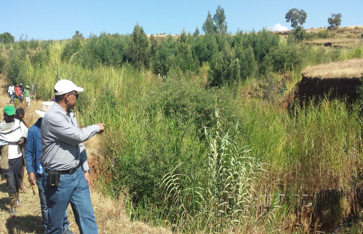
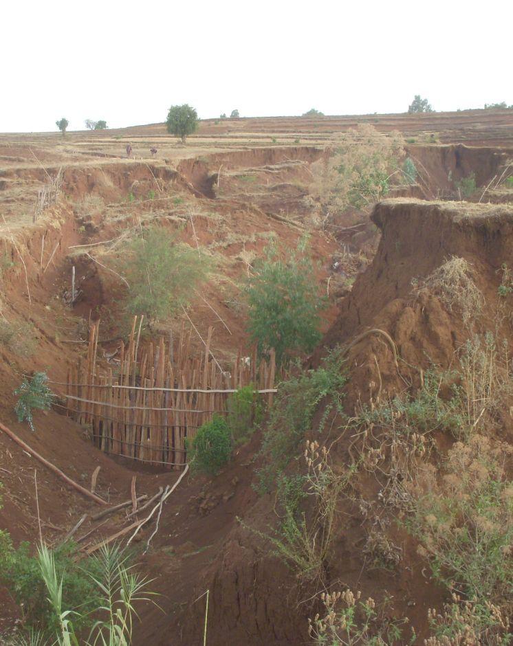
Gully erosion occurs on cultivated and grazing/pasture lands. Gully erosion management is a practice aimed to rehabilitate and protect further development of gullies and change into productive land. It involves both runoff management and erosion control activities. Gully management and treatment is different at upstream catchment area, gully head and gully section. Proper land management practices and slope treatment measures such as terraces, infiltration ditches and grass or shrub hedgerows are taking place on upstream catchment of the gully in order to reduce the rate of surface runoff. The excess runoff above the gully head is safely drained using cutoff drains into natural or properly vegetated waterways in order to reduce the surface water entering into the gully and protect the constructed physical and biological measures being washed away. Before treating gully sections, for the purpose of stability of structures and quick healing, the gully should be reshaped and planted with grass sod. Gully wall reshaping is cutting off steep slopes of active gully flanks in to gentle slope of minimum at 45% slope, up to two-third of the total depth of the gully and constructing small trenches along contours for re-vegetating slanted part of the gully walls and beds. If the gully is wide and has meandering nature with huge accumulation of runoff flowing down, it requires constructing of retaining walls, to protect displaced (not yet stabilized) soils and soil materials and the sidewalls of the reshaped gully. Stabilization of gully sections involves the use of structural and vegetative measures in the head, floor and side of the gully. The construction of physical structures inside the gully section is followed by establishment of biological measures.
Purposes of gully erosion management are: 1) rehabilitate the land damaged due to gully erosion, 2) prevent further expansion and development of gully erosion, and 3) convert the land lost by gully erosion to productive land.
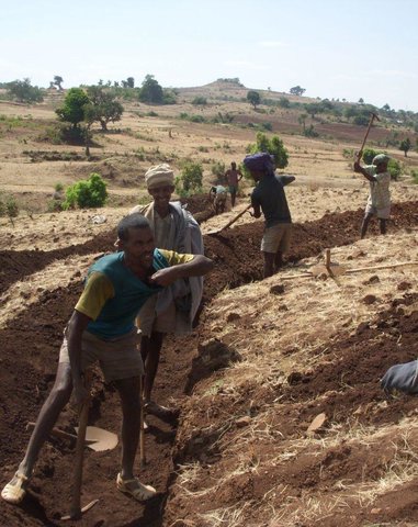
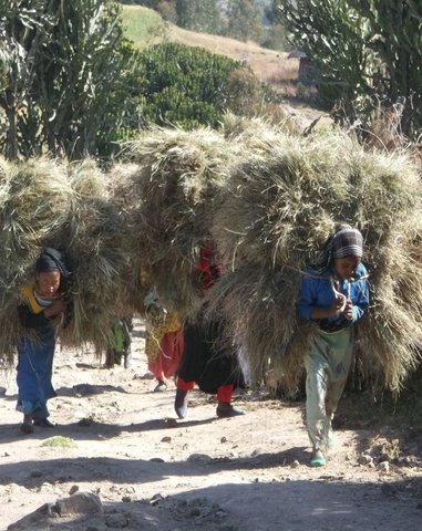
Gully erosion management begins with assessment and mapping of gully erosion that helps to have an overview of erosion, to document extent of damage, to identify the nature and causes of gully formation, and gives relevant information to design appropriate measures. At establishment stage, gully management requires: catchment treatment using different land treatment measures; runoff diversion by cutoff drain; and stabilization of gully sections by physical structures and vegetative measures. Stones for the construction of terraces, cutoff drains and waterways are required. Depending on the nature of gully and available material for construction, either stones, sand bags, brush woods, bamboo mat, gabion or concrete (sand, gravel and cement) are needed for constructing check-dams in a gully section. Different tree/shrub seedlings, grass cuttings, and seedlings of fruit trees are required to reinforce and stabilize the gully sections. The respective labor requirement for stone collection, construction of retaining wall, and gully reshaping is 0.5m3/person day, 5m/person day, and 1m3/person day. Approximately 0.25, 0.50, 0.50, 0.50 , and 1.0 m3/person day is required to construct gabion, loose stone, arc weir, sand bag, and bamboo mat check-dams respectively. About 3.0 m/person day is needed to construct brushwood check dams. The treated gullies should be checked regularly. The maintenance requirement is closely monitored and immediate repair is essential to avoid further damage and eventual collapse of structures. The inputs important for maintenance include stones or other materials for check dams, seedlings to replant areas covered with non-survived seedlings.
Gully erosion is prevalent in areas where excess runoff occurs in high rainfall areas associated with moderate to high erodible soils. It occurs in range of wet highland to moist Kolla areas where annual rainfall exceeds 900mm. Its occurrence is more frequent in heavy clay soils (Vertisols) characterized by low infiltration and in clay soils (like Nitosols) characterized by low organic matter. Often, gully formation occurs on overgrazed pasture lands and inappropriately managed crop lands. Gully erosion control requires mobilization of high input or materials and labor. Larger gullies need to be rehabilitated and treated through community labor mobilization. Subsequent maintenance activities, monitoring and benefit sharing should be made by the user groups who are entitled to utilize the benefits.
The living condition depends on subsistence crop-livestock mixed farming. On average households have 5-6 family size. Crop production is meant for home consumption with small surplus for local market. The services related to water supply, energy supply, and infrastructure are low. Besides it is an asset, animals often used to cope shocks during drought periods.
2.3 Технологийн гэрэл зураг
Медиа галерей
2.5 Энэ үнэлгээнд хамрагдсан технологийг хэрэгжүүлсэн улс орон / бүс нутаг / байршил
Улс :
Этиоп
Улс/аймаг/сум:
Amhara National Regional State (ANRS)
Байршлын дэлгэрэнгүй тодорхойлолт:
Dembecha/Mecha/Yilmana Densa
Технологи өргөн дэлгэрсэн эсхийг тодорхойл:
- газар дээр жигд тархсан
Хэрэв талбайн хэмжээ тодорхойгүй бол талбайн хэмжээг ойролцоогоор тодорхойлно уу.
- 10-100 км2
2.6 Хэрэгжих огноо
Байгуулсан тодорхой оныг мэдэхгүй бол баримжаа хугацааг тодорхойл:
- <10 жилийн өмнө (саяхны)
2.7 Технологийн танилцуулга
Технологийг хэрхэн нэвтрүүлснийг тодорхойл:
- Туршилт/судалгааны үр дүн
- Гадны төсөл/хөтөлбөрийн дэмжлэгтэйгээр
Тайлбар (төслийн төрөл г.м.):
Since gully erosion management requires combination of practices, many actors mainly research, local development actors, community, and project are involved in the development of the technology
3. ГТМ технологийн ангилал
3.1 Технологийн үндсэн зорилго (д)
- Газрын доройтлыг бууруулах, сэргийлэх, нөхөн сэргээх
3.2 Технологи хэвтрүүлсэн газрын одоогийн газар ашиглалтын хэлбэр(д)

Тариалангийн газар
- Нэг наст үр тариа
- Олон наст (модлог биш) тариалан
- Elphant grass, Sudan grass
Нэг жил дэх ургамал ургах улирлын тоо:
- 1
Тодорхойлно уу:
Longest growing period in days: 220, Longest growing period from month to month: May to December; Second longest growing period in days: 180, Second longest growing period from month to month: June to November

Бэлчээрийн газар
Нүүдлийн бэлчээр ашиглалт:
- Хагас нүүдлийн бэлчээрийн аж ахуй
Эрчимжсэн бэлчээр / тэжээл үйлдвэрлэл:
- Хадлан буюу бэлчээрт ашиглагдахгүй талбай
- free grazing

Байгалийн ой / модтой газар
- Susbania sesban, Acacia decurrence, treelucern, Acacia saligna
Бүтээгдэхүүн ба үйлчилгээ:
- Мод бэлтгэл
- Түлшний мод
Тайлбар:
Livestock density (if relevant):
> 100 LU /km2
Major land use problems (compiler’s opinion): Land degradation due to different forms of soil erosion and nutrient depletion, overgrazing, shortage of pasture lands and its low productivity, excessive and inappropriate construction of traditional ditches, and increased pressure on trees for the purpose of fuel wood and timber.
Major land use problems (land users’ perception): Soil erosion and soil nutrient depletion, shortage of cultivated land, shortage of grazing land and wood for fuel wood
The type of grazing is often free grazing on communal grazing lands/pasture, supplemented with crop residues and zero grazing combined with improved forages
3.4 Усан хангамж
Технологи хэрэгжүүлсэн газрын усан хангамж:
- Байгалийн усалгаатай
3.5 Технологи ГТМ-ийн аль бүлэгт хамаарах
- газар нутаг чөлөөлөх (ашиглалтыг зогсоох, нөхөн сэргээх)
3.6 Технологийг бүрдүүлэх ГТМ арга хэмжээ

Ургамалжилтын арга хэмжээ
- V1: Мод ба бут, сөөг
- V2: Өвс ба олон наст өвслөг ургамал

Барилга байгууламжийн арга хэмжээ
- S2: Далан, хаалт
- S3: Шаталсан суваг, шуувуу, гольдрол
- S4: Шаталсан шуудуу, нүх, хэвгий
- S6: Хашаа, саад, явган хашлага, хашаа
- S11: Бусад
Тайлбар:
Type of vegetative measures: aligned: -contour, aligned: -along boundary
3.7 Технологийн шийдвэрлэсэн газрын доройтлын үндсэн төрлүүд

Хөрс усаар эвдрэх
- Wg: Гуу жалгын элэгдэл
- Wo: Усны элэгдлийн дам нөлөө

Биологийн доройтол
- Bc: Ургамлан нөмрөг багасах
Тайлбар:
Main causes of degradation: deforestation / removal of natural vegetation (incl. forest fires), over-exploitation of vegetation for domestic use, overgrazing, Heavy / extreme rainfall (intensity/amounts), population pressure
Secondary causes of degradation: soil management, crop management (annual, perennial, tree/shrub), urbanisation and infrastructure development (Urbanization and infrastructure development induced excessive compaction, unprotected drainage systems and lead to gully formation), floods, land tenure (Land under undefined or communal use of grazing lands are subject to mismanagement that result in gully formation), poverty / wealth
3.8 Газрын доройтлоос урьдчилан сэргийлэх, сааруулах ба нөхөн сэргээх
Газрын доройтолтой холбоотойгоор Технологи ямар зорилго тавьсан болохыг тодорхойл:
- Газрын доройтлыг багасгах сааруулах
- Хүчтэй доройтсон газрыг нөхөн сэргээх/ сайжруулах
4. Техникийн нөхцөл, хэрэгжилтийн үйл ажиллагаа, материал ба зардал
4.1 Технологийн техникийн зураг
Техник тодорхойлолт (техник зурагтай уялдана):
A reshaped gully section treated with an integrated gully control measures including check dams made of loose stone and wooden and vegetative tree/shrub and grass hedgerows planted on the sides of gullies.
Location: Debre Mewi Learning Watershed. Yilmana Densa/West Gojam/Amhara Region
Date: 6/27/2016
Technical knowledge required for field staff / advisors: high (It requires knowledge of peak runoff and runoff management and skills to integrate different measures)
Technical knowledge required for land users: high (It needs skills to construct physical measures, and regular monitoring and maintenance of practices. The users must know and understand the growth nature and harvesting stage tree/shrub, grass species)
Main technical functions: control of concentrated runoff: impede / retard, control of concentrated runoff: drain / divert, reduction of slope angle
Secondary technical functions: reduction of slope length, improvement of ground cover, stabilisation of soil (eg by tree roots against land slides), increase of infiltration
Aligned: -contour
Vegetative material: T : trees / shrubs, G : grass
Number of plants per (ha): 2600
Spacing between rows / strips / blocks (m): 2-3
Vertical interval within rows / strips / blocks (m): 0.5-1.0
Width within rows / strips / blocks (m): 0.5
Aligned: -graded strips
Vegetative material: T : trees / shrubs
Aligned: -along boundary
Number of plants per (ha): 200
Vertical interval within rows / strips / blocks (m): 1
Width within rows / strips / blocks (m): 1
In blocks
Vegetative material: T : trees / shrubs
Vegetative measure: Alinged along side wall of gully
Vegetative material: T : trees / shrubs
Number of plants per (ha): 6800
Spacing between rows / strips / blocks (m): 2-3.0
Vertical interval within rows / strips / blocks (m): 0.5-1.0
Width within rows / strips / blocks (m): 0.5
Vegetative measure: Aligned along side wall of gully
Vegetative material: T : trees / shrubs
Number of plants per (ha): 4800
Spacing between rows / strips / blocks (m): 2-3.0
Vertical interval within rows / strips / blocks (m): 0.5
Width within rows / strips / blocks (m): 0.5
Vegetative measure: Vegetative material: T : trees / shrubs
Trees/ shrubs species: Susbania sesban, Acacia decurrence, treelucern, Acacia saligna
Grass species: Elphant grass, Sudan grass
Slope (which determines the spacing indicated above): 20-30%%
If the original slope has changed as a result of the Technology, the slope today is (see figure below): 18-25%%
Gradient along the rows / strips: 0.5%
Diversion ditch/ drainage
Depth of ditches/pits/dams (m): 0.3-0.7
Width of ditches/pits/dams (m): 1.2-2.8
Length of ditches/pits/dams (m): 100-250
Waterway
Depth of ditches/pits/dams (m): 0.3
Width of ditches/pits/dams (m): 1.5-2.0
Structural measure: Check dams
Vertical interval between structures (m): 1
Spacing between structures (m): 10-15
Height of bunds/banks/others (m): 1-1.5
Width of bunds/banks/others (m): 1.5-3.5
Construction material (earth): Excavated soil
Construction material (stone): Loose stones for check dam
Construction material (wood): Brush wood for check dam
Slope (which determines the spacing indicated above): 10-18%
If the original slope has changed as a result of the Technology, the slope today is: 8-12%
Vegetation is used for stabilisation of structures.
Зохиогч:
MOA, 2005, Water and Land Resource Center
4.2 Материал болон зардалд хамаарах ерөнхий мэдээлэл
бусад/үндэсний мөнгөн нэгж (тодорхойл):
ETB
Хэрэв боломжтой бол үндэсний валютын Америк доллартай харьцах харьцааг бичнэ үү (тухайлбал, 1 ам.дол. = 79,9 Бразил реал): 1 ам.дол. =:
20.0
Хөлсний ажилчны нэг өрдийн ажлын хөлсийг тодорхойл:
2.50
4.3 Байгуулах үйл ажиллагаа
| Үйл ажиллагаа | Хугацаа (улирал) | |
|---|---|---|
| 1. | Seedling preparation | January-June |
| 2. | Seedling Transportation | June-July |
| 3. | Grass split transportation | June -July |
| 4. | Plantation of biological measures inside the gully | July |
| 5. | Surveying | Dry season |
| 6. | Reshaping of gully | Dry season |
| 7. | Construction of cutoff drains | Dry season |
| 8. | Construction of waterways | Dry season |
| 9. | Construction of stone check dams | Dry season |
4.4 Байгуулалтад шаардагдах зардал ба материал
| Хөрөнгө оруулалтыг дурьдана уу | Хэмжих нэгж | Тоо хэмжээ | Нэгжийн өртөг | Материал бүрийн нийт өртөг | % газар ашиглачаас гарсан зардал | |
|---|---|---|---|---|---|---|
| Хөдөлмөр эрхлэлт | labour | ha | 1.0 | 8319.0 | 8319.0 | 99.0 |
| Тоног төхөөрөмж | animal traction | ha | 1.0 | 9.0 | 9.0 | 100.0 |
| Тоног төхөөрөмж | tools | ha | 1.0 | 901.8 | 901.8 | 50.0 |
| Таримал материал | grass | ha | 1.0 | 20.0 | 20.0 | |
| Таримал материал | seeds | ha | 1.0 | 24.0 | 24.0 | |
| Таримал материал | seedlings | ha | 1.0 | 63.45 | 63.45 | |
| Бордоо ба биоцид | compost/manure | ha | 1.0 | 15.86 | 15.86 | |
| Барилгын материал | stone | ha | 1.0 | 1405.0 | 1405.0 | 91.0 |
| Барилгын материал | wood | ha | 1.0 | 27.6 | 27.6 | |
| Барилгын материал | earth | ha | 1.0 | 91.2 | 91.2 | |
| Технологи бий болгох нийт үнэ өртөг | 10876.91 | |||||
| Технологи бий болгох нийт үнэ өртөг, ам.доллар | 543.85 | |||||
Тайлбар:
Duration of establishment phase: 15 month(s)
4.5 Засвар үйлчилгээ / давтагдах үйл ажиллагаа
| Үйл ажиллагаа | Хугацаа/ давтамж | |
|---|---|---|
| 1. | Seedling preparation | January-June |
| 2. | Seedling and grass split transportation | July |
| 3. | Replanting seedlings and grass splits | July |
| 4. | Maintenance of cutoff drains/waterways | Dry season (Jan-Apr) |
| 5. | Maintenance of check dams | Dry season (Jan-Apr) |
4.6 Засвар үйлчилгээ / урсгал үйл ажиллагаанд шаардагдах зардал ба материал (жилээр)
| Хөрөнгө оруулалтыг дурьдана уу | Хэмжих нэгж | Тоо хэмжээ | Нэгжийн өртөг | Материал бүрийн нийт өртөг | % газар ашиглачаас гарсан зардал | |
|---|---|---|---|---|---|---|
| Хөдөлмөр эрхлэлт | labour | ha | 1.0 | 902.0 | 902.0 | 67.0 |
| Тоног төхөөрөмж | animal traction | ha | 1.0 | 4.5 | 4.5 | |
| Таримал материал | grass | ha | 1.0 | 10.3 | 10.3 | |
| Таримал материал | seedlings | ha | 1.0 | 33.0 | 33.0 | |
| Бордоо ба биоцид | compost/manure | ha | 1.0 | 8.5 | 8.5 | |
| Барилгын материал | stone | ha | 1.0 | 50.0 | 50.0 | 41.0 |
| Барилгын материал | wood | ha | 1.0 | 14.4 | 14.4 | |
| Барилгын материал | earth | ha | 1.0 | 45.6 | 45.6 | |
| Технологийг арчилах тордоход шаардагдах нийт үнэ өртөг | 1068.3 | |||||
| Технологи сайжруулах нийт үнэ өртөг, ам.доллар | 53.41 | |||||
Тайлбар:
The costs are calculated on hectare basis
4.7 Зардалд нөлөөлж байгаа хамгийн чухал хүчин зүйл
Өртөг зардлыг тодорхойлох гол хүчин зүйлсийг дурьдана уу:
The costs for gully erosion management is dependent upon labor, material and transport costs, workability of the soil and maintenance costs.
5. Хүн, байгалийн хүрээлэн буй орчин
5.1 Уур амьсгал
Жилийн нийлбэр хур тундас
- <250 мм
- 251-500 мм
- 501-750 мм
- 751-1,000 мм
- 1,001-1,500 мм
- 1,501-2,000 мм
- 2,001-3,000 мм
- 3,001-4,000 мм
- > 4,000 мм
Хур тунадасны талаархи тодорхойлолт/ тайлбар:
Monsoon, 5-6 months rain and 6-7 dry months
Агро-уур амьсгалын бүс
- Хагас чийглэг
Thermal climate class: subtropics. The lowest temperature is above 5°C but below 18°C between November to January
5.2 Байрзүйн зураг
Дундаж налуу:
- Тэгш (0-2 %)
- Бага зэрэг хэвгий (3-5 %)
- Дунд зэрэг хэвгий (6-10 % )
- Долгиорхог (11-15 %)
- Толгодорхог (16-30 %)
- Эгц налуу (31-60 % )
- Огцом эгц налуу (>60 %)
Гадаргын хэлбэр:
- Тэгш өндөрлөг/тэгш тал
- Зоо, хяр
- Уулын энгэр, хажуу
- Ухаа, гүвээ, дов толгод
- Уулын бэл
- Хөндий, хоолой, нам хотос
Өндөршлийн бүс:
- 0-100 м д.т.д
- 101-500 м д.т.д
- 501-1,000 м д.т.д
- 1,001-1,500 м д.т.д
- 1,501-2,000 м д.т.д
- 2,001-2,500 м д.т.д
- 2,501-3,000 м д.т.д
- 3,001-4,000 м д.т.д
- > 4,000 м д.т.д
5.3 Хөрс
Хөрсний дундаж зузаан:
- Маш нимгэн (0-20 см)
- Нимгэн (21-50 см)
- Дунд зэрэг зузаан (51-80 см)
- Зузаан (81-120 cм)
- Маш зузаан (>120 cм)
Хөрсний бүтэц (өнгөн хөрс):
- Дунд зэрэг (шавранцар)
- Хүнд (шаварлаг)
Өнгөн хөрсний органик нэгдэл:
- Дунд (1-3 % )
- Бага (<1 % )
5.4 Усны хүртээм ба чанар
Хөрсний усны гүн:
5-50 м
Гадаргын усны хүртээмж:
Дунд зэрэг
Усны чанар (цэвэрлээгүй):
Муу чанарын ундны ус (цэвэршүүлэх шаардлагатай)
5.5 Биологийн төрөл зүйл
Зүйлийн олон янз байдал:
- Бага
5.6 Технологи нэвтрүүлсэн газар ашиглагчидын онцлог шинж
Үйлдвэрлэлийн системийн зах зээлийн чиг баримжаа:
- Амь зуух арга хэлбэрийн (өөрийгөө хангах)
Фермээс гадуурх орлого:
- Нийт орлогын %10 доош хувь
Чинээлэг байдлыг харьцангуй түвшин:
- Дундаж
Хувь хүн эсвэл бүлэг:
- бүлэг / олон нийтийн
Механикжилтын түвшин:
- Хүнд хүчир ажил
- Амьтны зүтгүүр
Хүйс:
- Эмэгтэй
- Эрэгтэй
Газар ашиглагчдын бусад шаардлагатай шинж чанарыг тодорхойл:
Land users applying the Technology are mainly common / average land users
Difference in the involvement of women and men: Women are involved in collecting stones and assisting men on heavy works
Population density: 200-500 persons/km2
Annual population growth: 2% - 3%
80% of the land users are average wealthy.
20% of the land users are poor.
Some land users involve in seasonal labor in towns and sell charcoal
5.7 Технологи нэвтрүүлэхэд газар ашиглагчийн ашигласан газрын дундаж талбай
- < 0.5 га
- 0.5-1 га
- 1-2 га
- 2-5 га
- 5-15 га
- 15-50 га
- 50-100 га
- 100-500 га
- 500-1,000 га
- 1,000-10,000 га
- > 10,000 га
Энэ нь жижиг, дунд, том оворт тооцогдох уу (орон нутгийн чиг баримжаагаар)?
- Бага-хэмжээний
5.8 Газар эзэмшил, газар ашиглах эрх, ус ашиглах эрх
Газар өмчлөл:
- Төр засаг
Ус ашиглах эрх:
- Нээлттэй хүртэх (зохион байгуулалтгүй)
- Нэгдлийн хэлбэрээр (зохион байгуулалттай)
Тайлбар:
Land use rights on crop land is individual while on grazing lands it is communal either unorganized or organized in some cases. Water is open accessible in most cases except organized communal utilization for some developed drinking water sources.
5.9 Дэд бүтэц, үйлчилгээний хүртээмж
эрүүл мэнд:
- Ядуу
- Дунд зэргийн
- Сайн
боловсрол:
- Ядуу
- Дунд зэргийн
- Сайн
техник дэмжлэг:
- Ядуу
- Дунд зэргийн
- Сайн
хөдөлмөр эрхлэлт (жишээ нь, ХАА-аас өөр):
- Ядуу
- Дунд зэргийн
- Сайн
зах зээл:
- Ядуу
- Дунд зэргийн
- Сайн
эрчим хүч:
- Ядуу
- Дунд зэргийн
- Сайн
зам ба тээвэр:
- Ядуу
- Дунд зэргийн
- Сайн
ундны ус ба ариутгал:
- Ядуу
- Дунд зэргийн
- Сайн
санхүүгийн үйлчилгээ:
- Ядуу
- Дунд зэргийн
- Сайн
6. Үр нөлөө ба дүгнэлт
6.1 Технологийн талбай дахь үр нөлөө
Нийгэм-эдийн засгийн үр нөлөө
Үйлдвэрлэл
тэжээл үйлдвэрлэл
Тайлбар/ тодорхой дурьдах:
Gullies are treated for purpose of improved grass and legume fodder production like napier, susbania, local grasses
олон янз бүтээгдэхүүн
Тайлбар/ тодорхой дурьдах:
Honey, fruits can be diversified under intensive gully development
Орлого, зарлага
орлогын олон янз эх үүсвэр
Тайлбар/ тодорхой дурьдах:
High fodder biomass provide an opportunity to do fattening; sometimes used to grow fruits;
хөдөлмөр хүчний хэмжээ
Тайлбар/ тодорхой дурьдах:
Under low productive soil where recovery rate is slow, establishment and maintenance cost of labor is high
Нийгэм-соёлын үр нөлөө
олон нийтийн институц
Тайлбар/ тодорхой дурьдах:
Watershed committee and user groups are established
ГТМ/ газрын доройтлын талаархи мэдлэг
Тайлбар/ тодорхой дурьдах:
Awareness of the community on gully management increased
маргааныг шийдвэрлэх
Тайлбар/ тодорхой дурьдах:
Gullies are stabilized and no more conflict
contribution to human well-being
Тайлбар/ тодорхой дурьдах:
Land users are organized into user groups and harvest the biomass (grass and fodder) for livestock feed which result in increased livestock productivity. Some land users attempt to fatten cattle and gain benefit.
Экологийн үр нөлөө
Усны эргэлт/ илүүдэл
гадаргын урсац
Тайлбар/ тодорхой дурьдах:
Significant reduction of damage due to runoff
илүүдэл ус урсгах
Тайлбар/ тодорхой дурьдах:
Cutoff drains used to drain excess runoff upstream
гүний усны түвшин / уст давхарга
Хөрс
хөрсөн бүрхэвч
Тайлбар/ тодорхой дурьдах:
Plantation of gullies increase cover and biomass production
хөрс алдагдах
Тайлбар/ тодорхой дурьдах:
Check dams significantly reduce the soil loss from gullies
Биологийн: ургамал, амьтан
газрын дээрхи / доорхи С
6.2 Технологийн талбайн гадна үзүүлсэн үр нөлөө
хуурай улиралд ашиглах найдвартай, тогтвортой урсгал
Тайлбар/ тодорхой дурьдах:
Stream size and duration has improved
урсацын адагт лаг шавар хуримтлагдана
нийтийн/хувийн хэвшлийн дэд бүтцэд учируулах хохирол
Тайлбар/ тодорхой дурьдах:
Reduction of damage on houses
6.3 Технологийн уур амьсгалын өөрчлөлт ба Уур амьсгалаас хамаарах аюул/гамшигт үзэгдэлд өртөх байдал ба эмзэг байдал (газар ашиглагч нарын дүгнэлтээр)
Уур амьсгалаас хамаарах аюулууд (гамшигууд)
Цаг уурын гамшигууд
| Технологи түүний нөлөөг хэрхэн бууруулж байна? | |
|---|---|
| Орон нутгийн аадар бороо | Сайн биш |
Уур амьсгалын гамшигууд
| Технологи түүний нөлөөг хэрхэн бууруулж байна? | |
|---|---|
| Ган гачиг | Сайн |
Гидрологийн гамшиг
| Технологи түүний нөлөөг хэрхэн бууруулж байна? | |
|---|---|
| усны үер (гол) | Сайн биш |
Тайлбар:
Gully erosion management involves combination of biological and physical measures. Strong structural measures and upstream runoff management practices should be applied to tolerate flooding.
6.4 Зардал ба үр ашгийн шинжилгээ
Үр ашгийг барилга байгууламжийн зардалтай (газар ашиглагчдын үзэл бодлоор) хэрхэн харьцуулах вэ?
Богино хугацаанд эргэн төлөгдөх байдал:
Бага зэрэг эерэг
Урт хугацаанд эргэн төлөгдөх байдал:
Эерэг
Үр ашгийг засвар үйлчилгээ/ урсгал зардалтай (газар ашиглагчдын үзэл бодлоор) хэрхэн харьцуулах вэ?
Богино хугацаанд эргэн төлөгдөх байдал:
Эерэг
Урт хугацаанд эргэн төлөгдөх байдал:
Маш эерэг
Тайлбар:
The short term economic benefits of management of gully erosion include grass and fodder production for livestock feed. While the long term benefits may include product diversification like fruit, fodder, and grass production.
6.5 Технологи нутагшуулах
Тайлбар:
About 3-5% of the total area of watersheds are treated with gully management. Gullies formed on crop lands and communal grazing lands are management collectively by the community labor with external material support such as gabion and seedlings
Gully management is beyond the capacity of land users. So, they are often supported with seedlings and gabions for large gullies
There is a little trend towards spontaneous adoption of the Technology
Land users show interest and motivation by delineating gully damage areas and control free grazing. They also do fencing with external support for nails and seedlings.
6.7 Технологийн давуу тал/боломжууд
| Газар ашиглагчдын тодорхойлсон давуу тал/боломжууд |
|---|
| It increases fodder production |
| It protects further expansion and damage of settlement areas and infrastructures |
| It increases the flow of streams |
| Эмхэтгэгч, бусад мэдээлэл өгсөн хүмүүсийн өнцгөөс тодорхойлсон давуу тал/боломжууд |
|---|
| Gully erosion management provides an immediate fodder for cut-and-carry grazing system and encourages zero grazing |
| It controls erosion and sediment transport as well it increases stream flows to downstream and subsequently changed to productive area |
| It reduces conflict among adjacent land holders due to formation of gullies |
| It does not only reduce degradation but also stabilize the soil, water and vegetation system in the area |
| It increases the awareness level of farmers about land degradation and its causes |
6.8 Технологийн дутагдалтай/сул тал/аюул болон тэдгээрийн хэрхэн даван туулах арга замууд
| Газар ашиглагч нарын тодорхойлсон сул тал/ дутагдал/ эрсдэл | Тэдгээрийг хэрхэн даван туулах вэ? |
|---|---|
| It is labor intensive and sometimes harbor rodents and pests | Apply traditional collective action mechanisms |
| Эмхэтгэгч, бусад мэдээлэл өгсөн хүмүүсийн өнцгөөс тодорхойлсон сул тал/ дутагдал/ эрсдэл | Тэдгээрийг хэрхэн даван туулах вэ? |
|---|---|
| It requires high labor for regular monitoring and maintenance of structures and protect from damage by excessive runoff | Establish by laws and procedures for collective actions among the user groups |
7. Ном зүй ба холбоосууд
7.1 Мэдээллийн аргууд / эх сурвалжууд
- Хээрийн уулзалт, судалгаа
- Газар ашиглагчтай хийсэн ярилцлага
7.2 Хүртээмжтэй ном, бүтээлийн ишлэл
Гарчиг, зохиогч, он, ISBN:
Gully Rehabilitation: What Does it Costs to Heal Gullies and Make Productive? WLRC Brief No. 3. June 2015
Хаанаас авч болох вэ? Зардал?
www.wlrc-eth.org
Холбоос ба модулууд
Бүгдийг харуулах Бүгдийг хаахХолбоосууд
Community Organizations and Mobilization for Soil and Water … [Этиоп]
Community mobilization for soil and water conservation work in a watershed planning unit is an approach for collective action by organizing all active labor forces living in the kebele/peasant association into development group of 20-30 members and further divide into 1:5 work force to implement construction of soil and water …
- Мэдээлэл цуглуулсан: Gizaw Desta Gessesse
'Cut and Carry' Grazing system or 'Zero Grazing' … [Этиоп]
Cut and carry grazing system (alternatively called zero grazing) is an approach where the community is consulted to identify and agree on areas to be closed and protected from free grazing; establish user groups are established to share the fodder biomass harvested from communal closed areas equitably; they utilize tree/shrub …
- Мэдээлэл цуглуулсан: Gizaw Desta Gessesse
Модулууд
Модуль байхгүй байна